ATL: IAN - Post-Tropical - Discussion

Moderator: S2k Moderators

Message
Author
User avatar
Ed_2001
Tropical Storm
Tropical Storm
Posts: 240
Age: 23
Joined: Wed Jun 21, 2017 11:39 pm
Location: Santa Barbara, CA>>Tampa, FL

Re: ATL: IAN - Hurricane - Discussion

#4761 Postby Ed_2001 » Wed Sep 28, 2022 9:58 am

Comanche wrote:How often does a system like this go through an eyewall replacement cycle?

Eyewall replacement is an extremely common process in higher intensity TC’s. In fact I’d say most strong TC’s go through, or at least attempt an ewrc cycle at some point in their life
Last edited by Ed_2001 on Wed Sep 28, 2022 9:59 am, edited 1 time in total.
5 likes   
The answer my friend, is blowing in the wind...

User avatar
Hypercane_Kyle
Category 5
Category 5
Posts: 3353
Joined: Sat Mar 07, 2015 7:58 pm
Location: Cape Canaveral, FL

Re: ATL: IAN - Hurricane - Discussion

#4762 Postby Hypercane_Kyle » Wed Sep 28, 2022 9:58 am

Comanche wrote:How often does a system like this go through an eyewall replacement cycle?


It completed a major eye-wall replacement cycle yesterday. The timing, unfortunately, resulted in the storm peaking right before FL landfall.
7 likes   
My posts are my own personal opinion, defer to the National Hurricane Center (NHC) and other NOAA products for decision making during hurricane season.

tolakram
Admin
Admin
Posts: 20012
Age: 62
Joined: Sun Aug 27, 2006 8:23 pm
Location: Florence, KY (name is Mark)

Re: ATL: IAN - Hurricane - Discussion

#4763 Postby tolakram » Wed Sep 28, 2022 9:58 am

Image
6 likes   
M a r k
- - - - -
Join us in chat: Storm2K Chatroom Invite. Android and IOS apps also available.

The posts in this forum are NOT official forecasts and should not be used as such. Posts are NOT endorsed by any professional institution or STORM2K.org. For official information and forecasts, please refer to NHC and NWS products.

User avatar
chris_fit
Category 5
Category 5
Posts: 3222
Age: 42
Joined: Wed Sep 10, 2003 11:58 pm
Location: Tampa Bay Area, FL

Re: ATL: IAN - Hurricane - Discussion

#4764 Postby chris_fit » Wed Sep 28, 2022 9:58 am

Image
8 likes   

User avatar
Cyclenall
Category 5
Category 5
Posts: 6666
Joined: Thu Jun 08, 2006 10:01 pm
Location: Ontario, Canada

Re: ATL: IAN - Hurricane - Discussion

#4765 Postby Cyclenall » Wed Sep 28, 2022 9:59 am

GCANE wrote:Just looked at 200mb vort at CIMSS.
Ian is pushing back the PV streamers to its west, making room for longer term intensification.

This was from a few nights ago, but I was wondering what causes those PV streamers out there in the GOM like that? Great to see you back GCANE!

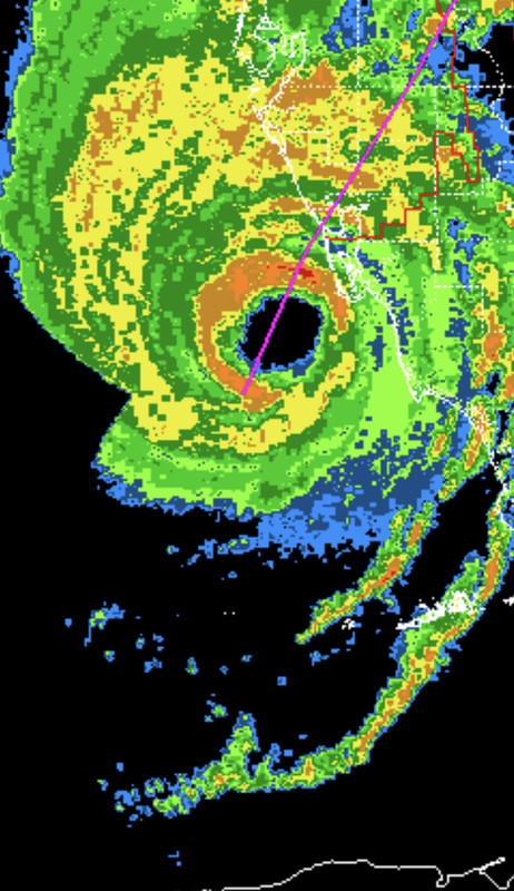
Currently, its an unexpected turn of events but I wouldn't bet on a CAT5 landfall just due to the incredible rarity of US CAT5 LFs and the slow movement of Ian (and heading). Even if its one now. I give it 15% chance. 130-135 knot LF exponentially higher odds. I agree with those that think this is going to be the worst hurricane the west coast of FL has ever seen, this is history.
8 likes   

User avatar
Texas Snowman
Storm2k Moderator
Storm2k Moderator
Posts: 6179
Joined: Fri Jan 25, 2008 11:29 am
Location: Denison, Texas

Re: ATL: IAN - Hurricane - Discussion

#4766 Postby Texas Snowman » Wed Sep 28, 2022 9:59 am


This landfall may be at Captiva Island?
5 likes   
The above post and any post by Texas Snowman is NOT an official forecast and should not be used as such. It is just the opinion of the poster and may or may not be backed by sound meteorological data. It is NOT endorsed by any professional institution including storm2k.org. For official information, please refer to NWS products.

User avatar
Blown Away
S2K Supporter
S2K Supporter
Posts: 10147
Joined: Wed May 26, 2004 6:17 am

Re: ATL: IAN - Hurricane - Discussion

#4767 Postby Blown Away » Wed Sep 28, 2022 10:00 am

Image

Slight wobble E, eyewall at edge of Sanibel…
5 likes   
Hurricane Eye Experience: David 79, Irene 99, Frances 04, Jeanne 04, Wilma 05... EYE COMING MY WAY IN 2024…
Hurricane Brush Experience: Andrew 92, Erin 95, Floyd 99, Matthew 16, Irma 17, Ian 22, Nicole 22…

Sciencerocks
Category 5
Category 5
Posts: 9155
Age: 39
Joined: Thu Jul 06, 2017 1:51 am

Re: ATL: IAN - Hurricane - Discussion

#4768 Postby Sciencerocks » Wed Sep 28, 2022 10:01 am

Image
7 likes   

User avatar
galaxy401
Category 5
Category 5
Posts: 2419
Age: 30
Joined: Sat Aug 25, 2012 9:04 pm
Location: Casa Grande, Arizona

Re: ATL: IAN - Hurricane - Discussion

#4769 Postby galaxy401 » Wed Sep 28, 2022 10:02 am

Do we have any more recon missions planned or is that going to be it until landfall?
3 likes   
Got my eyes on moving right into Hurricane Alley: Florida.

zzzh
Category 3
Category 3
Posts: 834
Joined: Thu Sep 02, 2021 1:13 pm

Re: ATL: IAN - Hurricane - Discussion

#4770 Postby zzzh » Wed Sep 28, 2022 10:02 am

Air Force Reserve and NOAA Hurricane Hunter data was absolutely
critical this morning in diagnosing the rapid intensification of
Ian, despite both planes undergoing multiple eyewall penetrations
experiencing severe turbulence. That data supported an intensity of
about 135 kt a few hours ago. Since that time, high-resolution
Tampa Doppler radar data has been sampling the eyewall near 10,000
ft with winds up to 155 kt, indicating that Ian is on the threshold
of category 5 status. The maximum winds are set to 135 kt on this
advisory.

Could be a Category 5 in post season analysis
15 likes   

User avatar
Extratropical94
Professional-Met
Professional-Met
Posts: 3538
Age: 30
Joined: Wed Oct 20, 2010 6:36 am
Location: Hamburg, Germany
Contact:

Re: ATL: IAN - Hurricane - Discussion

#4771 Postby Extratropical94 » Wed Sep 28, 2022 10:04 am

galaxy401 wrote:Do we have any more recon missions planned or is that going to be it until landfall?


Next mission leaves in an hour. Maybe we get one more center pass before landfall.
7 likes   
54° 11' 59'' N, 9° 9' 20'' E
Boomer Sooner!
Go Broncos! Go Cards! Go Niners!
- Daniel

tolakram
Admin
Admin
Posts: 20012
Age: 62
Joined: Sun Aug 27, 2006 8:23 pm
Location: Florence, KY (name is Mark)

Re: ATL: IAN - Hurricane - Discussion

#4772 Postby tolakram » Wed Sep 28, 2022 10:05 am

Blurry but highest water that is still working. Ft Meyers cam went down.
Image
4 likes   
M a r k
- - - - -
Join us in chat: Storm2K Chatroom Invite. Android and IOS apps also available.

The posts in this forum are NOT official forecasts and should not be used as such. Posts are NOT endorsed by any professional institution or STORM2K.org. For official information and forecasts, please refer to NHC and NWS products.

underthwx
Category 5
Category 5
Posts: 2362
Joined: Sat Jul 30, 2011 2:14 pm
Location: Brazoria County Texas

Re: ATL: IAN - Hurricane - Discussion

#4773 Postby underthwx » Wed Sep 28, 2022 10:05 am

How far from the center are Tropical Storm strength winds, and Hurricane force winds being experienced?
3 likes   

User avatar
cheezyWXguy
Category 5
Category 5
Posts: 6108
Joined: Mon Feb 13, 2006 12:29 am
Location: Dallas, TX

Re: ATL: IAN - Hurricane - Discussion

#4774 Postby cheezyWXguy » Wed Sep 28, 2022 10:05 am

zzzh wrote:
Air Force Reserve and NOAA Hurricane Hunter data was absolutely
critical this morning in diagnosing the rapid intensification of
Ian, despite both planes undergoing multiple eyewall penetrations
experiencing severe turbulence. That data supported an intensity of
about 135 kt a few hours ago. Since that time, high-resolution
Tampa Doppler radar data has been sampling the eyewall near 10,000
ft with winds up to 155 kt, indicating that Ian is on the threshold
of category 5 status. The maximum winds are set to 135 kt on this
advisory.

Could be a Category 5 in post season analysis

I think it will be. Radar velocities are more extreme than Laura and Ida had, maybe more than what I saw in Michael
7 likes   

jdjaguar
Category 2
Category 2
Posts: 551
Joined: Fri Aug 26, 2005 12:07 pm
Location: Jacksonville Beach, FL

Re: ATL: IAN - Hurricane - Discussion

#4775 Postby jdjaguar » Wed Sep 28, 2022 10:06 am

wxman57 wrote:
jdjaguar wrote:
kevin wrote:Perhaps the best Ian has looked on visible so far this morning:

https://i.imgur.com/Nis4fBs.jpg

is that a pinhole eye? :eek:


NO! Eye is 30nm across.

Good, thanks. Visually it appeared to be, my mistake for not looking at the data before posting.
Storm is bad enough.
4 likes   

User avatar
PTPatrick
Category 5
Category 5
Posts: 1831
Joined: Sat Jun 12, 2004 8:38 am

Re: ATL: IAN - Hurricane - Discussion

#4776 Postby PTPatrick » Wed Sep 28, 2022 10:06 am

another thing re surge...if this wobbles even a tad more east I could see charlotte harbor missing some of the highest surge numbers. I think fort meyers gets the brunt regardless, but a few miles difference on the eastern eyewall could make a world of difference for how much gets driven into charlotte harbor. direct middle path of the eye often misses the worst surge...but we are talking miles and its heavily dependent on coastal geometry and storms angle of approach and structure.
5 likes   

Fancy1001
Category 1
Category 1
Posts: 452
Joined: Thu Jul 16, 2020 10:16 pm

Re: ATL: IAN - Hurricane - Discussion

#4777 Postby Fancy1001 » Wed Sep 28, 2022 10:07 am

Please let them upgrade it before.
2 likes   

Maryellen46
Tropical Low
Tropical Low
Posts: 23
Joined: Tue Sep 05, 2017 1:09 pm

Re: ATL: IAN - Hurricane - Discussion

#4778 Postby Maryellen46 » Wed Sep 28, 2022 10:07 am


Morons doing it for their stupid Tik Toks.
5 likes   

User avatar
ObsessedMiami
Category 1
Category 1
Posts: 431
Joined: Tue Aug 31, 2004 8:08 pm
Location: West Kendall, Fl

Re: ATL: IAN - Hurricane - Discussion

#4779 Postby ObsessedMiami » Wed Sep 28, 2022 10:08 am

underthwx wrote:How far from the center are Tropical Storm strength winds, and Hurricane force winds being experienced?

Clearly getting TS gusts in West Miami Dade if that tells you anything
7 likes   

User avatar
ElectricStorm
Category 5
Category 5
Posts: 5049
Age: 24
Joined: Tue Aug 13, 2019 11:23 pm
Location: Skiatook, OK / Norman, OK

Re: ATL: IAN - Hurricane - Discussion

#4780 Postby ElectricStorm » Wed Sep 28, 2022 10:09 am

Fancy1001 wrote:Please let them upgrade it before.

It literally means nothing if it's upgraded or not right now
4 likes   
B.S Meteorology, University of Oklahoma '25

Please refer to the NHC, NWS, or SPC for official information.


Return to “2022”

Who is online

Users browsing this forum: No registered users and 0 guests