
I have confirmed that this is mostly inflated from Sleet and it's in the fantasy range.
Texas Fall 2022
Moderator: S2k Moderators
Forum rules

The posts in this forum are NOT official forecast and should not be used as such. They are just the opinion of the poster and may or may not be backed by sound meteorological data. They are NOT endorsed by any professional institution or STORM2K.
-
Iceresistance

- Category 5

- Posts: 9581
- Age: 22
- Joined: Sat Oct 10, 2020 9:45 am
- Location: Tecumseh, OK/Norman, OK
Re: Texas Fall 2022
I have confirmed that this is mostly inflated from Sleet and it's in the fantasy range.
1 likes
Bill 2015 & Beta 2020
Winter 2020-2021
All observations are in Tecumseh, OK unless otherwise noted.
Winter posts are focused mainly for Oklahoma & Texas.
Take any of my forecasts with a grain of salt, refer to the NWS, SPC, and NHC for official information
Never say Never with weather! Because ANYTHING is possible!
Winter 2020-2021
All observations are in Tecumseh, OK unless otherwise noted.
Winter posts are focused mainly for Oklahoma & Texas.
Take any of my forecasts with a grain of salt, refer to the NWS, SPC, and NHC for official information
Never say Never with weather! Because ANYTHING is possible!

Re: Texas Fall 2022
Definitely will take more rain but if the storm's could just hold off until 11 pm or so Friday night here in East Texas so I can enjoy my bird/hog hunt that would be greeeaaaaat. 
0 likes
-
bubba hotep

- S2K Supporter

- Posts: 6014
- Joined: Wed Dec 28, 2016 1:00 am
- Location: Collin County Texas
Re: Texas Fall 2022
cheezyWXguy wrote:cheezyWXguy wrote:18z gfs looks quite favorable for severe weather Friday night. 500mb pattern shows the cutoff low tilting negative and strengthening as it transits into Texas. The resultant shear profiles, coupled with depicted cape of >1500j/kg looks like an all-hazards event across ntx to me.
The map below is based on the 18z gfs. Wonder if future runs will continue to show such a strong signal
[url]https://i.ibb.co/qp7fjHK/A4-C114-A2-B4-AE-49-CE-B064-9-DA9006-BBBA7.jpg [/url]
Edit, actually think it’s the 12z. Regardless, pretty colors, high chances, etc etc. Take with as few grains of salt as you would any individual gfs run
SPC agrees and has a pretty big D4 15%

2 likes
Winter time post are almost exclusively focused on the DFW area.
-
Iceresistance
- Category 5
- Posts: 9581
- Age: 22
- Joined: Sat Oct 10, 2020 9:45 am
- Location: Tecumseh, OK/Norman, OK
Re: Texas Fall 2022
bubba hotep wrote:cheezyWXguy wrote:cheezyWXguy wrote:18z gfs looks quite favorable for severe weather Friday night. 500mb pattern shows the cutoff low tilting negative and strengthening as it transits into Texas. The resultant shear profiles, coupled with depicted cape of >1500j/kg looks like an all-hazards event across ntx to me.
The map below is based on the 18z gfs. Wonder if future runs will continue to show such a strong signal
[url]https://i.ibb.co/qp7fjHK/A4-C114-A2-B4-AE-49-CE-B064-9-DA9006-BBBA7.jpg [/url]
Edit, actually think it’s the 12z. Regardless, pretty colors, high chances, etc etc. Take with as few grains of salt as you would any individual gfs run
SPC agrees and has a pretty big D4 15%
https://pbs.twimg.com/media/FgezPa6WAAE0G5G?format=jpg&name=medium
Could be enough for an Enhanced risk for most of Oklahoma and into Northern and Central Texas.
0 likes
Bill 2015 & Beta 2020
Winter 2020-2021
All observations are in Tecumseh, OK unless otherwise noted.
Winter posts are focused mainly for Oklahoma & Texas.
Take any of my forecasts with a grain of salt, refer to the NWS, SPC, and NHC for official information
Never say Never with weather! Because ANYTHING is possible!
Winter 2020-2021
All observations are in Tecumseh, OK unless otherwise noted.
Winter posts are focused mainly for Oklahoma & Texas.
Take any of my forecasts with a grain of salt, refer to the NWS, SPC, and NHC for official information
Never say Never with weather! Because ANYTHING is possible!
-
cheezyWXguy

- Category 5
- Posts: 6282
- Joined: Mon Feb 13, 2006 12:29 am
- Location: Dallas, TX
Re: Texas Fall 2022
Iceresistance wrote:bubba hotep wrote:cheezyWXguy wrote:The map below is based on the 18z gfs. Wonder if future runs will continue to show such a strong signal
[url]https://i.ibb.co/qp7fjHK/A4-C114-A2-B4-AE-49-CE-B064-9-DA9006-BBBA7.jpg [/url]
Edit, actually think it’s the 12z. Regardless, pretty colors, high chances, etc etc. Take with as few grains of salt as you would any individual gfs run
SPC agrees and has a pretty big D4 15%
https://pbs.twimg.com/media/FgezPa6WAAE0G5G?format=jpg&name=medium
Could be enough for an Enhanced risk for most of Oklahoma and into Northern and Central Texas.
I think there’s a decent chance someone ends up in an enhanced risk. How large an area, or if there are higher risk levels, will depend on how the system transits. 18z gfs was the peak so far of severe potential, with the cutoff turning negative. Subsequent runs have gotten a little bit faster and more neutral, which would likely limit discrete cells and push the line through earlier.
However, the nam is getting into range and has more consistently shown a transit similar to the 18z gfs.
0 likes
-
bubba hotep
- S2K Supporter
- Posts: 6014
- Joined: Wed Dec 28, 2016 1:00 am
- Location: Collin County Texas
Re: Texas Fall 2022
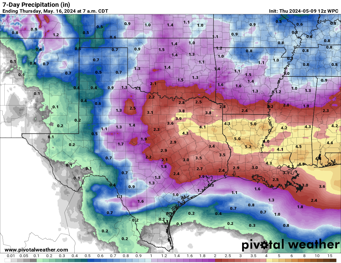
WPC going with another multi-inch event for North Texas, however, this time the highest totals will be focused northward into OK/KS.
0 likes
Winter time post are almost exclusively focused on the DFW area.
-
Iceresistance
- Category 5
- Posts: 9581
- Age: 22
- Joined: Sat Oct 10, 2020 9:45 am
- Location: Tecumseh, OK/Norman, OK
Re: Texas Fall 2022
SE Texas is getting drenched on radar right now.
1 likes
Bill 2015 & Beta 2020
Winter 2020-2021
All observations are in Tecumseh, OK unless otherwise noted.
Winter posts are focused mainly for Oklahoma & Texas.
Take any of my forecasts with a grain of salt, refer to the NWS, SPC, and NHC for official information
Never say Never with weather! Because ANYTHING is possible!
Winter 2020-2021
All observations are in Tecumseh, OK unless otherwise noted.
Winter posts are focused mainly for Oklahoma & Texas.
Take any of my forecasts with a grain of salt, refer to the NWS, SPC, and NHC for official information
Never say Never with weather! Because ANYTHING is possible!
-
bubba hotep
- S2K Supporter
- Posts: 6014
- Joined: Wed Dec 28, 2016 1:00 am
- Location: Collin County Texas
Re: Texas Fall 2022
Iceresistance wrote:SE Texas is getting drenched on radar right now.
Looks like the same old story for SA, decent totals out west of them in the Big Bend and then decent totals to the south and east of them. SA can't catch a break.
1 likes
Winter time post are almost exclusively focused on the DFW area.
-
Edwards Limestone

- S2K Supporter
- Posts: 510
- Age: 36
- Joined: Tue Dec 28, 2021 11:05 am
- Location: Smithson Valley, TX
Re: Texas Fall 2022
1 likes
The above post is NOT an official forecast and should not be used as such. It is just the opinion of the poster and may or may not be backed by sound meteorological data. It is NOT endorsed by any professional institution including Storm2k. For official information, please refer to NWS products.
-
Edwards Limestone
- S2K Supporter
- Posts: 510
- Age: 36
- Joined: Tue Dec 28, 2021 11:05 am
- Location: Smithson Valley, TX
Re: Texas Fall 2022
bubba hotep wrote:Iceresistance wrote:SE Texas is getting drenched on radar right now.
Looks like the same old story for SA, decent totals out west of them in the Big Bend and then decent totals to the south and east of them. SA can't catch a break.
We got 0.02" at the airport last night...lol.

0 likes
The above post is NOT an official forecast and should not be used as such. It is just the opinion of the poster and may or may not be backed by sound meteorological data. It is NOT endorsed by any professional institution including Storm2k. For official information, please refer to NWS products.
-
South Texas Storms

- Professional-Met

- Posts: 4256
- Joined: Thu Jun 24, 2010 12:28 am
- Location: Houston, TX
Re: Texas Fall 2022
Edwards Limestone wrote:bubba hotep wrote:Iceresistance wrote:SE Texas is getting drenched on radar right now.
Looks like the same old story for SA, decent totals out west of them in the Big Bend and then decent totals to the south and east of them. SA can't catch a break.
We got 0.02" at the airport last night...lol.
How is it possible to miss the heavier totals on every rain event in a year? It's pretty unbelievable how it keeps happening...
0 likes
-
weatherdude1108
- Category 5
- Posts: 4228
- Joined: Tue Dec 13, 2011 1:04 pm
- Location: Northwest Austin/Cedar Park, TX
Re: Texas Fall 2022
South Texas Storms wrote:Edwards Limestone wrote:bubba hotep wrote:
Looks like the same old story for SA, decent totals out west of them in the Big Bend and then decent totals to the south and east of them. SA can't catch a break.
We got 0.02" at the airport last night...lol.
How is it possible to miss the heavier totals on every rain event in a year? It's pretty unbelievable how it keeps happening...
I don't get it either.
0 likes
The preceding post is NOT an official forecast, and should not be used as such. It is only the opinion of the poster and may or may not be backed by sound meteorological data. It is NOT endorsed by any professional institution including storm2k.org. For Official Information please refer to the NHC and NWS products.

Re: Texas Fall 2022
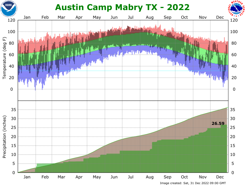
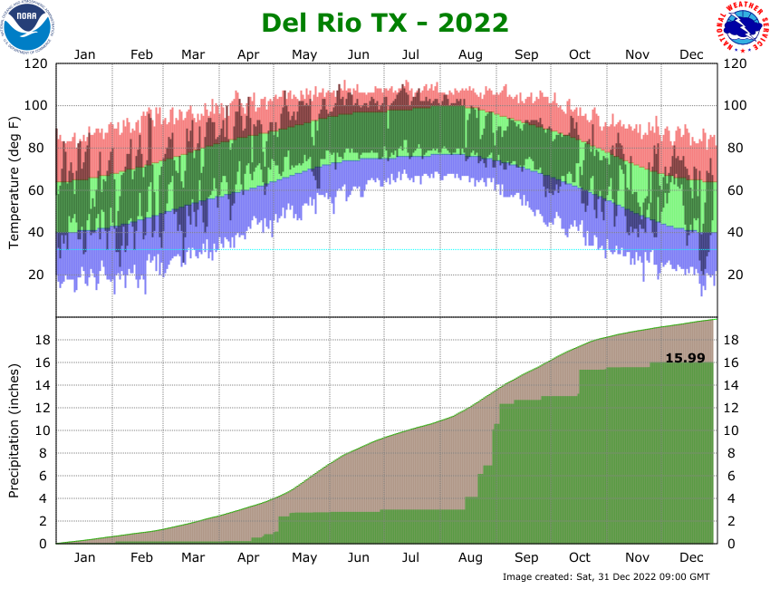
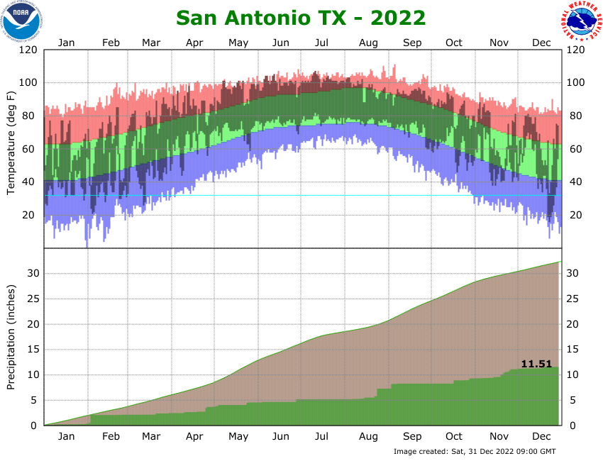
Whoa, it's a total mystery why Beaumont and Houston have gotten more rain than San Antonio.

2 likes
-
Edwards Limestone
- S2K Supporter
- Posts: 510
- Age: 36
- Joined: Tue Dec 28, 2021 11:05 am
- Location: Smithson Valley, TX
Re: Texas Fall 2022
dpep4 wrote:Whoa, it's a total mystery why Beaumont and Houston have gotten more rain than San Antonio.
https://pbs.twimg.com/media/DIVnIMHXcAA4TVj.jpg
Great, now explain this

5 likes
The above post is NOT an official forecast and should not be used as such. It is just the opinion of the poster and may or may not be backed by sound meteorological data. It is NOT endorsed by any professional institution including Storm2k. For official information, please refer to NWS products.
-
bubba hotep
- S2K Supporter
- Posts: 6014
- Joined: Wed Dec 28, 2016 1:00 am
- Location: Collin County Texas
Re: Texas Fall 2022
dpep4 wrote:Whoa, it's a total mystery why Beaumont and Houston have gotten more rain than San Antonio.
https://pbs.twimg.com/media/DIVnIMHXcAA4TVj.jpg
Such an odd troll.
3 likes
Winter time post are almost exclusively focused on the DFW area.
-
bubba hotep
- S2K Supporter
- Posts: 6014
- Joined: Wed Dec 28, 2016 1:00 am
- Location: Collin County Texas

-
Brent
- S2K Supporter
- Posts: 38740
- Age: 37
- Joined: Sun May 16, 2004 10:30 pm
- Location: Tulsa Oklahoma
- Contact:

Re: Texas Fall 2022
Brent wrote:
That long range GFS keeps trying to be interesting
The CPC seems to think most of the cold will stay up north and the south and east will stay above normal.
0 likes
-
bubba hotep
- S2K Supporter
- Posts: 6014
- Joined: Wed Dec 28, 2016 1:00 am
- Location: Collin County Texas
Re: Texas Fall 2022
Brent wrote:
That long range GFS keeps trying to be interesting
That's how they always start!
1 likes
Winter time post are almost exclusively focused on the DFW area.
-
Brent
- S2K Supporter
- Posts: 38740
- Age: 37
- Joined: Sun May 16, 2004 10:30 pm
- Location: Tulsa Oklahoma
- Contact:
Re: Texas Fall 2022
Cpv17 wrote:Brent wrote:
That long range GFS keeps trying to be interesting
The CPC seems to think most of the cold will stay up north and the south and east will stay above normal.
The apps do get colder here after day 7 so we'll see. I always take the end of the GFS as fantasy but to see it trying to consistently show something is interesting anyway
0 likes
#neversummer
Return to “USA & Caribbean Weather”
Who is online
Users browsing this forum: Brent and 72 guests