#1165 Postby LarryWx » Wed Nov 09, 2022 3:54 pm
Cat5James wrote:StormingB81 wrote:wxman57 wrote:
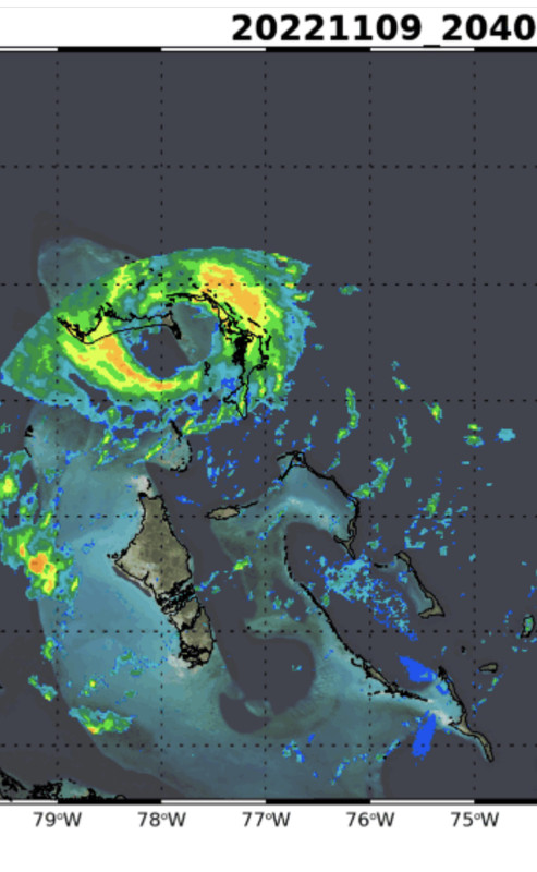
I doubt any TV station is running "in-house" models. With a storm that has such a large area of TS winds, the exact landfall point is less important. Any hurricane force winds may cover only a few square miles out over the water. Expect some strong tropical storm-force winds north of where the center reaches the coast. Beyond then, all that cool, dry air over Florida now will be flowing into Nicole, knocking its core down fairly quickly. Not a big rain producer. I see the latest EC forecasting only 2-3 inches across the eastern half of the Peninsula. This is no Ian. It'll be all gone by Friday afternoon. So ends the season (I hope).
They have been. They always do. They even said “this is our in-house model” they’ve been showing it the last few days. Like I said it was great in Ian, it was great in Irma which showed pretty much exactly what it did days before. I understand what you’re saying but they are using them.
Nicole would have to take a sharp NW turn now to land close to Brevard
I disagree that it needs to turn sharply NW yet to have a chance to get close to Brevard. But it will need to start turning WNW very soon per models.
Last edited by
LarryWx on Wed Nov 09, 2022 3:54 pm, edited 1 time in total.
0 likes
Personal Forecast Disclaimer:
The posts in this forum are NOT official forecasts and should not be used as such. They are just the opinion of the poster and may or may not be backed by sound meteorological data. They are NOT endorsed by any professional institution or storm2k.org. For official information, please refer to the NHC and NWS products.