Ntxw wrote:In case you were wondering the highest modern times prior was 2021's 1058mb over land in NW Canada just before the plunge.
https://i.imgur.com/ivqIgQE.gif
Would this have an impact on bringing snow to Texas or extreme cold?
Moderator: S2k Moderators
 The posts in this forum are NOT official forecast and should not be used as such. They are just the opinion of the poster and may or may not be backed by sound meteorological data. They are NOT endorsed by any professional institution or STORM2K.


Ntxw wrote:In case you were wondering the highest modern times prior was 2021's 1058mb over land in NW Canada just before the plunge.
https://i.imgur.com/ivqIgQE.gif


SnowintheFalls wrote:Ntxw wrote:In case you were wondering the highest modern times prior was 2021's 1058mb over land in NW Canada just before the plunge.
https://i.imgur.com/ivqIgQE.gif
Would this have an impact on bringing snow to Texas or extreme cold?


Ntxw wrote:SnowintheFalls wrote:Ntxw wrote:In case you were wondering the highest modern times prior was 2021's 1058mb over land in NW Canada just before the plunge.
https://i.imgur.com/ivqIgQE.gif
Would this have an impact on bringing snow to Texas or extreme cold?
Cold.
FW put out a graphic recently. Could probably shave 5-10 degrees off this easily.
https://i.imgur.com/f6mXIKW.png


Ntxw wrote:While we wait for the 0z models a fun read of a much forgotten late December cold blast few talk about. December 1929. Hillsboro holds the state record for 26" snowfall in 24 hours. Not much is said about this event and maps for it are hard to find even in reanalysis. But even a slight +PNA ridge didn't stop it!
https://i.imgur.com/MyHS2qJ.png
This is the best I could pull from the 20c reanalysis.
Pattern leading up the the event.
https://i.imgur.com/4LKQWH1.png
The event
https://i.imgur.com/yJ7XC1z.png
https://i.imgur.com/daTJXtD.png
Cpv17 wrote:Ntxw wrote:While we wait for the 0z models a fun read of a much forgotten late December cold blast few talk about. December 1929. Hillsboro holds the state record for 26" snowfall in 24 hours. Not much is said about this event and maps for it are hard to find even in reanalysis. But even a slight +PNA ridge didn't stop it!
https://i.imgur.com/MyHS2qJ.png
This is the best I could pull from the 20c reanalysis.
Pattern leading up the the event.
https://i.imgur.com/4LKQWH1.png
The event
https://i.imgur.com/yJ7XC1z.png
https://i.imgur.com/daTJXtD.png
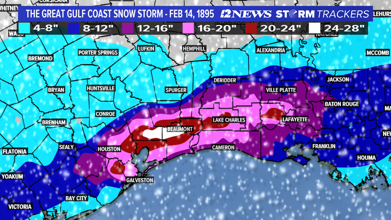
Check out this one from 1895:
https://i.postimg.cc/zfxTLRz0/607-B26-F1-E18-F-4-F6-A-86-EC-7-B6-F73-E24-A3-E.png


Wntrwthrguy wrote:Any idea what we should expect to see on the 0z runs? Should we expect westward trend to continue? Anything we should watch for that would increase precip chances?
Iceresistance wrote:I forget, does anyone know the time on when the 0z ICON starts?
 ) just posted the chances of a White Christmas are increasing
Ntxw wrote:Iceresistance wrote:I forget, does anyone know the time on when the 0z ICON starts?
It started.

Iceresistance wrote:0z ICON has already trended WAY colder compared to 12z and 18z.
Ntxw wrote:Iceresistance wrote:0z ICON has already trended WAY colder compared to 12z and 18z.
But it is also different than the 12z run and sends a TPV lobe to Ontario?
Iceresistance wrote:Ntxw wrote:Iceresistance wrote:0z ICON has already trended WAY colder compared to 12z and 18z.
But it is also different than the 12z run and sends a TPV lobe to Ontario?
I've also noticed that, hopefully it's just an outlier (being weird as well) and not the beginning of a trend for other models to follow. That would be annoying!
UPDATE: Nope! It still comes in with the cold and snow! Not the definition of a "Blue Norther" but still nasty cold!
Users browsing this forum: Stratton23, Teban54, wxman22 and 59 guests


