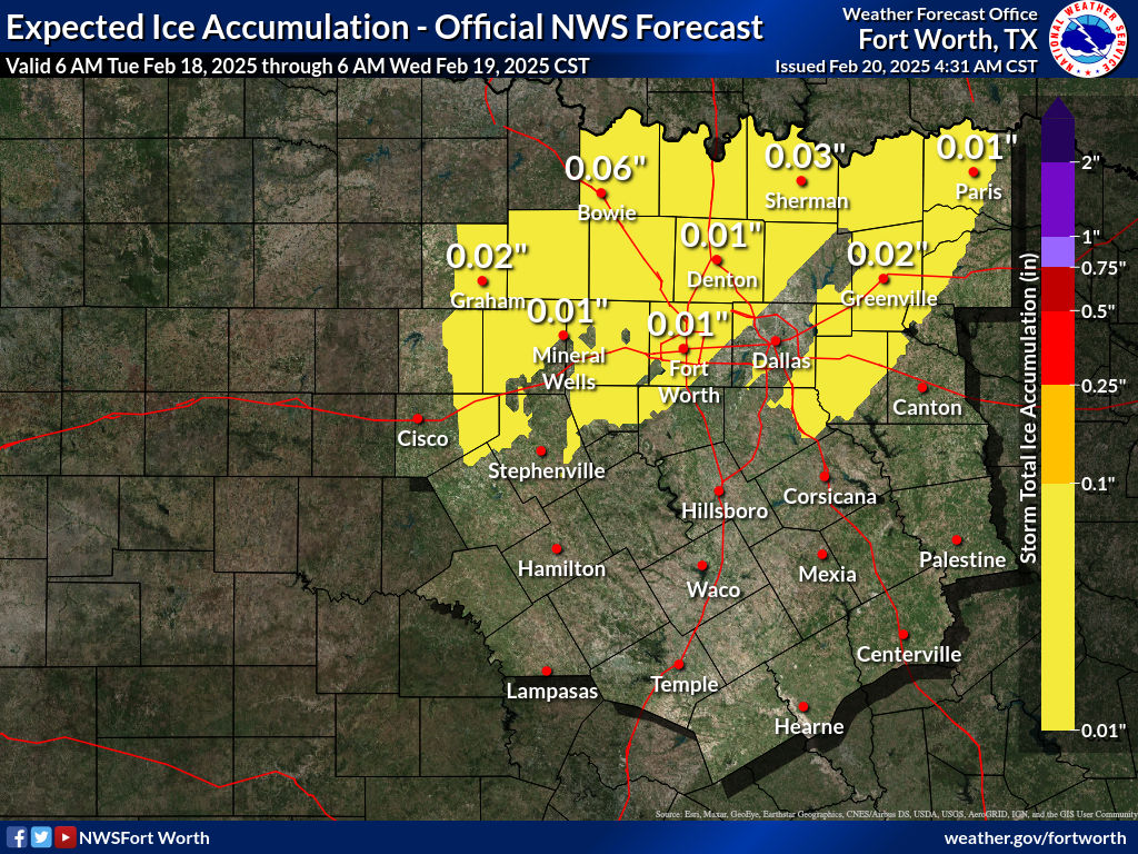
Gotwood wrote:https://www.weather.gov/images/fwd/winter/StormTotalIceWeb.jpg
Praying this is wrong.
That is a wild map, but well supported by the models.
Moderator: S2k Moderators
 The posts in this forum are NOT official forecast and should not be used as such. They are just the opinion of the poster and may or may not be backed by sound meteorological data. They are NOT endorsed by any professional institution or STORM2K.

Gotwood wrote:https://www.weather.gov/images/fwd/winter/StormTotalIceWeb.jpg
Praying this is wrong.


Gotwood wrote:https://www.weather.gov/images/fwd/winter/StormTotalIceWeb.jpg
Praying this is wrong.
txtwister78 wrote:Gotwood wrote:https://www.weather.gov/images/fwd/winter/StormTotalIceWeb.jpg
Praying this is wrong.
Think it is in terms of precip type. They updated their graphic this morning at 8 AM to account for the trends regarding precip type/sleet accumulation. I'm sure they'll have another update later this afternoon though for tomorrow beyond.


Ralph's Weather wrote:Gotwood wrote:https://www.weather.gov/images/fwd/winter/StormTotalIceWeb.jpg
Praying this is wrong.
That is a wild map, but well supported by the models.
orangeblood wrote:txtwister78 wrote:Gotwood wrote:https://www.weather.gov/images/fwd/winter/StormTotalIceWeb.jpg
Praying this is wrong.
Think it is in terms of precip type. They updated their graphic this morning at 8 AM to account for the trends regarding precip type/sleet accumulation. I'm sure they'll have another update later this afternoon though for tomorrow beyond.
Don’t think they’ll need to update much, latest extended HRRR which coincides with NAM….brings over an 1” plus QPF over wide swath. Trying hard to erode freezing temps but really slow to do so and probably still too fast given past performance
https://images.weatherbell.com/model/hrrr/tx/frzr_total/1675188000/1675332000-16uTd05WORg.png
cheezyWXguy wrote:Ralph's Weather wrote:Gotwood wrote:https://www.weather.gov/images/fwd/winter/StormTotalIceWeb.jpg
Praying this is wrong.
That is a wild map, but well supported by the models.
What does it show? When I clicked on it, the map was blank
txtwister78 wrote:orangeblood wrote:txtwister78 wrote:
Think it is in terms of precip type. They updated their graphic this morning at 8 AM to account for the trends regarding precip type/sleet accumulation. I'm sure they'll have another update later this afternoon though for tomorrow beyond.
Don’t think they’ll need to update much, latest extended HRRR which coincides with NAM….brings over an 1” plus QPF over wide swath. Trying hard to erode freezing temps but really slow to do so and probably still too fast given past performance
https://images.weatherbell.com/model/hrrr/tx/frzr_total/1675188000/1675332000-16uTd05WORg.png
I don't know if that's all going to be freezing rain though based on the HRRR algorithm fail this morning. NAM probably has a better handle regarding that and vastly different with the freezing rain accumulations into Wed afternoon (has more sleet for DFW again). Looks like HRRR is setting up for another round of convective sleet to me as this ULL begins to eject out. Probably why these freezing rain accumulations are being "overdone" a bit further north in certain spots compared to some of the other guidance.

orangeblood wrote:txtwister78 wrote:Gotwood wrote:https://www.weather.gov/images/fwd/winter/StormTotalIceWeb.jpg
Praying this is wrong.
Think it is in terms of precip type. They updated their graphic this morning at 8 AM to account for the trends regarding precip type/sleet accumulation. I'm sure they'll have another update later this afternoon though for tomorrow beyond.
Don’t think they’ll need to update much, latest extended HRRR which coincides with NAM….brings over an 1” plus QPF over wide swath. Trying hard to erode freezing temps but really slow to do so and probably still too fast given past performance
https://images.weatherbell.com/model/hrrr/tx/frzr_total/1675188000/1675332000-16uTd05WORg.png
bubba hotep wrote:orangeblood wrote:txtwister78 wrote:
Think it is in terms of precip type. They updated their graphic this morning at 8 AM to account for the trends regarding precip type/sleet accumulation. I'm sure they'll have another update later this afternoon though for tomorrow beyond.
Don’t think they’ll need to update much, latest extended HRRR which coincides with NAM….brings over an 1” plus QPF over wide swath. Trying hard to erode freezing temps but really slow to do so and probably still too fast given past performance
https://images.weatherbell.com/model/hrrr/tx/frzr_total/1675188000/1675332000-16uTd05WORg.png
In addition to the temp timing, all of these batches of QPF have come in faster than the models showed. So that also favors more QPF during the sub-freezing temp window.
EnnisTx wrote:bubba hotep wrote:orangeblood wrote:
Don’t think they’ll need to update much, latest extended HRRR which coincides with NAM….brings over an 1” plus QPF over wide swath. Trying hard to erode freezing temps but really slow to do so and probably still too fast given past performance
https://images.weatherbell.com/model/hrrr/tx/frzr_total/1675188000/1675332000-16uTd05WORg.png
In addition to the temp timing, all of these batches of QPF have come in faster than the models showed. So that also favors more QPF during the sub-freezing temp window.
Thoughts on the system pulling in colder air for a brief window of snow over North Texas?

rwfromkansas wrote:Seems they think Dallas will be above freezing. No warning for Dallas.
rwfromkansas wrote:Seems they think Dallas will be above freezing. No warning for Dallas.
rwfromkansas wrote:Seems they think Dallas will be above freezing. No warning for Dallas.
Users browsing this forum: No registered users and 191 guests


