2023 Global Model Runs Discussion (Out thru day 16)

This is the general tropical discussion area. Anyone can take their shot at predicting a storms path.

Moderator: S2k Moderators

Forum rules

The posts in this forum are NOT official forecasts and should not be used as such. They are just the opinion of the poster and may or may not be backed by sound meteorological data. They are NOT endorsed by any professional institution or STORM2K. For official information, please refer to products from the National Hurricane Center and National Weather Service.

Help Support Storm2K
Message
Author
User avatar
TheAustinMan
Category 5
Category 5
Posts: 1047
Age: 25
Joined: Mon Jul 08, 2013 4:26 pm
Location: United States
Contact:

Re: 2023 Global Model Runs Discussion (Out thru day 16)

#301 Postby TheAustinMan » Fri Jun 16, 2023 11:37 am

Shortwave Trough / Mid-Level Shortwave over Oklahoma [Today] → Frontal Wave Off SE US Coast [Sunday]
A shortwave trough is currently located over Oklahoma/Kansas, and is closed (between roughly the 925mb–500mb level) but not too well-stacked aloft. You may be rightfully wondering what in the world this has to do with anything tropical. Over the next few days, this shortwave is expected to move southeast and should reach the Florida/Georgia border Saturday night. After that, it'll swing east and northeast along a decaying front / baroclinic zone off the East Coast after moving offshore sometime Sunday.

As a general rule of thumb, regardless of model consensus for tropical cyclone development or not, frontal waves off the East Coast of the US often provide seedlings for tropical cyclones throughout the hurricane season. These sorts of developments often sneak up on model guidance (think of all the various, rapidly organizing but typically weak tropical storms that have formed off the coast in recent years). If this particular disturbance can get sufficient convective activity going offshore (and find an area of lower wind shear), it has some shot of organizing into a tropical cyclone (note the low tracks off the East Coast on the GEFS and EPS). Based on the projected steering, the precursor system will likely be more impactful with regard to severe weather and flooding over the SE US than whatever offshore system develops, but it could nonetheless be something to watch for the wx enthusiasts and shipping out there.

GEFS 6z Low Tracks off the East Coast. Source: Weathernerds.org
Image
7 likes   
ImageImageImage
Treat my opinions with a grain of salt. For official information see your local weather service.

Camerooski
Tropical Low
Tropical Low
Posts: 47
Joined: Wed Aug 08, 2018 5:40 pm
Location: Lauderdale-By-the-Sea ---> Coral Gables

Re: 2023 Global Model Runs Discussion (Out thru day 16)

#302 Postby Camerooski » Fri Jun 16, 2023 11:44 am

Shortwave Trough --> transitioning into a possible TC to help erode periphery of blocking high and push future "Bert/Cindy" OTS and spare the islands? :sun:
0 likes   

User avatar
Hurricanehink
S2K Supporter
S2K Supporter
Posts: 2040
Joined: Sun Nov 16, 2003 2:05 pm
Location: New Jersey

Re: 2023 Global Model Runs Discussion (Out thru day 16)

#303 Postby Hurricanehink » Fri Jun 16, 2023 1:01 pm

If both storms form before 06 UTC on 6/20, then Cindy would be the earliest fourth named storm on record. The current record is Tropical Storm Danielle in June 2016, a year that also had a January system and an early June storm in the northeastern Gulf of Mexico.
3 likes   

User avatar
Teban54
Category 5
Category 5
Posts: 3204
Joined: Sat May 19, 2018 1:19 pm

Re: 2023 Global Model Runs Discussion (Out thru day 16)

#304 Postby Teban54 » Fri Jun 16, 2023 5:00 pm

Apparently EPS says just one June MDR storm isn't enough...

 https://twitter.com/WxPatel/status/1669797982827413504


0 likes   

User avatar
Cpv17
Category 5
Category 5
Posts: 4976
Joined: Wed Dec 07, 2016 2:24 pm
Location: Wharton/El Campo, TX

Re: 2023 Global Model Runs Discussion (Out thru day 16)

#305 Postby Cpv17 » Fri Jun 16, 2023 5:22 pm

Teban54 wrote:Apparently EPS says just one June MDR storm isn't enough...

https://twitter.com/WxPatel/status/1669797982827413504


I’m interested in the second system. Haven’t heard anything about a second system till I saw this. Interesting.
0 likes   

User avatar
AnnularCane
S2K Supporter
S2K Supporter
Posts: 2862
Joined: Thu Jun 08, 2006 9:18 am
Location: Wytheville, VA

Re: 2023 Global Model Runs Discussion (Out thru day 16)

#306 Postby AnnularCane » Fri Jun 16, 2023 6:30 pm

Mother Nature accidentally flipped through a couple extra pages on her calendar. :lol:
1 likes   
"But it never rained rain. It never snowed snow. And it never blew just wind. It rained things like soup and juice. It snowed mashed potatoes and green peas. And sometimes the wind blew in storms of hamburgers." -- Judi Barrett, Cloudy with a Chance of Meatballs

User avatar
Teban54
Category 5
Category 5
Posts: 3204
Joined: Sat May 19, 2018 1:19 pm

Re: 2023 Global Model Runs Discussion (Out thru day 16)

#307 Postby Teban54 » Fri Jun 16, 2023 6:41 pm

0 likes   

User avatar
Woofde
Category 1
Category 1
Posts: 479
Joined: Tue Jul 06, 2021 11:33 am

Re: 2023 Global Model Runs Discussion (Out thru day 16)

#308 Postby Woofde » Fri Jun 16, 2023 7:12 pm

June 16th is a little early to be tracking potential MDR systems, but here we are. The waters are definitely warm enough.
0 likes   

User avatar
Teban54
Category 5
Category 5
Posts: 3204
Joined: Sat May 19, 2018 1:19 pm

Re: 2023 Global Model Runs Discussion (Out thru day 16)

#309 Postby Teban54 » Fri Jun 16, 2023 11:41 pm

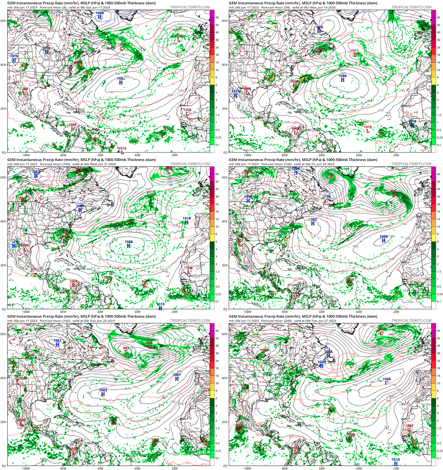
LemieT wrote:In observing the models recently, it seems the CMC's name has changed from Constantly Making Cyclones to Can't Make Cyclones.

This didn't age well:
Image
4 likes   

User avatar
JetFuel_SE
Category 1
Category 1
Posts: 282
Age: 25
Joined: Thu Apr 30, 2020 3:57 pm

Re: 2023 Global Model Runs Discussion (Out thru day 16)

#310 Postby JetFuel_SE » Sat Jun 17, 2023 1:29 am

Teban54 wrote:
LemieT wrote:In observing the models recently, it seems the CMC's name has changed from Constantly Making Cyclones to Can't Make Cyclones.

This didn't age well:
https://i.postimg.cc/4dtR5fGc/gem-mslp-pcpn-atl-fh6-240.gif

The thing is, there is some support for at least one additional system from the ECMWF ensembles.
0 likes   

User avatar
chaser1
S2K Supporter
S2K Supporter
Posts: 5464
Age: 64
Joined: Sat Oct 15, 2005 5:59 pm
Location: Longwood, Fl

Re: 2023 Global Model Runs Discussion (Out thru day 16)

#311 Postby chaser1 » Sat Jun 17, 2023 2:11 am

Teban54 wrote:
LemieT wrote:In observing the models recently, it seems the CMC's name has changed from Constantly Making Cyclones to Can't Make Cyclones.

This didn't age well:
https://i.postimg.cc/4dtR5fGc/gem-mslp-pcpn-atl-fh6-240.gif


Okay, now THAT'S funny :sun: Throw in the EPAC, and I count 4 of 'em in that 10 day forecast.
0 likes   
Andy D

(For official information, please refer to the NHC and NWS products.)

User avatar
Ivanhater
Storm2k Moderator
Storm2k Moderator
Posts: 11161
Age: 38
Joined: Fri Jul 01, 2005 8:25 am
Location: Pensacola

Re: 2023 Global Model Runs Discussion (Out thru day 16)

#312 Postby Ivanhater » Sat Jun 17, 2023 4:33 am

Well looks like 92L isn't just a fluke but the start of Cape Verde season in June. :double:

In fact most global models have 1-2 more right behind 92L. The Canadian image has 2 (not including 92L)

ImageImage


Sent from my moto g stylus 5G (2022) using Tapatalk
Image
1 likes   
Michael

User avatar
aspen
Category 5
Category 5
Posts: 8818
Joined: Sat Oct 12, 2019 7:10 pm
Location: Connecticut, USA

Re: 2023 Global Model Runs Discussion (Out thru day 16)

#313 Postby aspen » Sat Jun 17, 2023 9:17 am

TheAustinMan wrote:Shortwave Trough / Mid-Level Shortwave over Oklahoma [Today] → Frontal Wave Off SE US Coast [Sunday]
A shortwave trough is currently located over Oklahoma/Kansas, and is closed (between roughly the 925mb–500mb level) but not too well-stacked aloft. You may be rightfully wondering what in the world this has to do with anything tropical. Over the next few days, this shortwave is expected to move southeast and should reach the Florida/Georgia border Saturday night. After that, it'll swing east and northeast along a decaying front / baroclinic zone off the East Coast after moving offshore sometime Sunday.

As a general rule of thumb, regardless of model consensus for tropical cyclone development or not, frontal waves off the East Coast of the US often provide seedlings for tropical cyclones throughout the hurricane season. These sorts of developments often sneak up on model guidance (think of all the various, rapidly organizing but typically weak tropical storms that have formed off the coast in recent years). If this particular disturbance can get sufficient convective activity going offshore (and find an area of lower wind shear), it has some shot of organizing into a tropical cyclone (note the low tracks off the East Coast on the GEFS and EPS). Based on the projected steering, the precursor system will likely be more impactful with regard to severe weather and flooding over the SE US than whatever offshore system develops, but it could nonetheless be something to watch for the wx enthusiasts and shipping out there.

GEFS 6z Low Tracks off the East Coast. Source: Weathernerds.org
[url]https://i.ibb.co/P4DNNbg/image.png [/url]

06z 3km NAM (yes I know it’s the NAM) shows this developing into a 1004mb TS by Monday afternoon. So far the globals aren’t really biting, most keeping it as just a low.
0 likes   
Irene '11 Sandy '12 Hermine '16 5/15/2018 Derecho Fay '20 Isaias '20 Elsa '21 Henri '21 Ida '21

I am only a meteorology enthusiast who knows a decent amount about tropical cyclones. Look to the professional mets, the NHC, or your local weather office for the best information.

St0rmTh0r
Category 1
Category 1
Posts: 369
Joined: Tue Jul 14, 2020 8:04 pm

Re: 2023 Global Model Runs Discussion (Out thru day 16)

#314 Postby St0rmTh0r » Sat Jun 17, 2023 9:59 am

Ivanhater wrote:Well looks like 92L isn't just a fluke but the start of Cape Verde season in June. :double:

In fact most global models have 1-2 more right behind 92L. The Canadian image has 2 (not including 92L)

https://uploads.tapatalk-cdn.com/20230617/fa3f3258ed1adfdac3a5ea675a9fdb3b.jpg https://uploads.tapatalk-cdn.com/20230617/f13f2cf035c809c984397e9a38ba97eb.jpg


Sent from my moto g stylus 5G (2022) using Tapatalk
https://uploads.tapatalk-cdn.com/20230617/6e83d819673d1a8f837f261380bd49ba.jpg

really unprecedented not sure what this means for the future
0 likes   

User avatar
cycloneye
Admin
Admin
Posts: 145299
Age: 68
Joined: Thu Oct 10, 2002 10:54 am
Location: San Juan, Puerto Rico

Re: 2023 Global Model Runs Discussion (Out thru day 16)

#315 Postby cycloneye » Sat Jun 17, 2023 11:29 am

ICON dropped 92L but develops wave behind.
0 likes   
Visit the Caribbean-Central America Weather Thread where you can find at first post web cams,radars
and observations from Caribbean basin members Click Here

User avatar
cycloneye
Admin
Admin
Posts: 145299
Age: 68
Joined: Thu Oct 10, 2002 10:54 am
Location: San Juan, Puerto Rico

Re: 2023 Global Model Runs Discussion (Out thru day 16)

#316 Postby cycloneye » Sat Jun 17, 2023 11:45 am

CMC develops the wave behind 92L.

Image
0 likes   
Visit the Caribbean-Central America Weather Thread where you can find at first post web cams,radars
and observations from Caribbean basin members Click Here

User avatar
chaser1
S2K Supporter
S2K Supporter
Posts: 5464
Age: 64
Joined: Sat Oct 15, 2005 5:59 pm
Location: Longwood, Fl

Re: 2023 Global Model Runs Discussion (Out thru day 16)

#317 Postby chaser1 » Sat Jun 17, 2023 11:49 am

cycloneye wrote:ICON dropped 92L but develops wave behind.


That run seems suspicious. The 6Z doesn't depict any significant speed or directional change to mid or upper level winds, nor the speed in which the system is moving. Purely a guess here but I think that we'll see the ICON pick the system back up this upcoming 12Z run.
0 likes   
Andy D

(For official information, please refer to the NHC and NWS products.)

User avatar
Hypercane_Kyle
Category 5
Category 5
Posts: 3352
Joined: Sat Mar 07, 2015 7:58 pm
Location: Cape Canaveral, FL

Re: 2023 Global Model Runs Discussion (Out thru day 16)

#318 Postby Hypercane_Kyle » Sat Jun 17, 2023 11:55 am

Would be wild if 2023 had a robust CV season beginning in June and lasting through September.
4 likes   
My posts are my own personal opinion, defer to the National Hurricane Center (NHC) and other NOAA products for decision making during hurricane season.

User avatar
Cyclenall
Category 5
Category 5
Posts: 6666
Joined: Thu Jun 08, 2006 10:01 pm
Location: Ontario, Canada

Re: 2023 Global Model Runs Discussion (Out thru day 16)

#319 Postby Cyclenall » Sat Jun 17, 2023 12:22 pm

Hypercane_Kyle wrote:Would be wild if 2023 had a robust CV season beginning in June and lasting through September.

Due to how wx patterns and oscillators behave, I'd say it would be more unlikely than even the Super Outbreak or March 2012 NA heat event to have a sustained CV season starting now with no notable lull. I don't want to say its impossible but my idea is I'd have to have a 20,000 year dataset to find a few.
2 likes   

User avatar
aspen
Category 5
Category 5
Posts: 8818
Joined: Sat Oct 12, 2019 7:10 pm
Location: Connecticut, USA

Re: 2023 Global Model Runs Discussion (Out thru day 16)

#320 Postby aspen » Sat Jun 17, 2023 1:55 pm

cycloneye wrote:CMC develops the wave behind 92L.

https://i.imgur.com/r1h3uYa.gif

It also finally has something come out of 92L, albeit very weak. Until today, the CMC has been the one outlier model showing no development.
2 likes   
Irene '11 Sandy '12 Hermine '16 5/15/2018 Derecho Fay '20 Isaias '20 Elsa '21 Henri '21 Ida '21

I am only a meteorology enthusiast who knows a decent amount about tropical cyclones. Look to the professional mets, the NHC, or your local weather office for the best information.


Return to “Talkin' Tropics”

Who is online

Users browsing this forum: No registered users and 29 guests