AL, 92, 2023061800, , BEST, 0, 98N, 292W, 20, 1011, WV
ATL: BRET - Remnants - Discussion
Moderator: S2k Moderators
-
cycloneye

- Admin

- Posts: 149716
- Age: 69
- Joined: Thu Oct 10, 2002 10:54 am
- Location: San Juan, Puerto Rico
Re: ATL: INVEST 92L - Discussion
00z Best Track.
1 likes
Visit the Caribbean-Central America Weather Thread where you can find at first post web cams,radars
and observations from Caribbean basin members Click Here
and observations from Caribbean basin members Click Here
-
cycloneye
- Admin
- Posts: 149716
- Age: 69
- Joined: Thu Oct 10, 2002 10:54 am
- Location: San Juan, Puerto Rico
Re: ATL: INVEST 92L - Discussion
3 likes
Visit the Caribbean-Central America Weather Thread where you can find at first post web cams,radars
and observations from Caribbean basin members Click Here
and observations from Caribbean basin members Click Here
-
cycloneye
- Admin
- Posts: 149716
- Age: 69
- Joined: Thu Oct 10, 2002 10:54 am
- Location: San Juan, Puerto Rico
Re: ATL: INVEST 92L - Discussion
Is organizing in a faster pace now.


7 likes
Visit the Caribbean-Central America Weather Thread where you can find at first post web cams,radars
and observations from Caribbean basin members Click Here
and observations from Caribbean basin members Click Here
-
toad strangler

- S2K Supporter

- Posts: 4546
- Joined: Sun Jul 28, 2013 3:09 pm
- Location: Earth
- Contact:
Re: ATL: INVEST 92L - Discussion
This would be nuts to see on 7/17 let alone 6/17.
4 likes
My Weather Station
https://www.wunderground.com/dashboard/pws/KFLPORTS603
https://www.wunderground.com/dashboard/pws/KFLPORTS603
-
dexterlabio
- Category 5

- Posts: 3517
- Joined: Sat Oct 24, 2009 11:50 pm
Re: ATL: INVEST 92L - Discussion
Reminds me of Hurricane Danny, but 2 months earlier 
0 likes
Personal Forecast Disclaimer:
The posts in this forum are NOT official forecast and should not be used as such. They are just the opinion of the poster and may or may not be backed by sound meteorological data. They are NOT endorsed by any professional institution or storm2k.org. For official information, please refer to the NHC and NWS products.
The posts in this forum are NOT official forecast and should not be used as such. They are just the opinion of the poster and may or may not be backed by sound meteorological data. They are NOT endorsed by any professional institution or storm2k.org. For official information, please refer to the NHC and NWS products.
-
Hurricane2022

- Category 5
- Posts: 2092
- Joined: Tue Aug 23, 2022 11:38 pm
- Location: Araçatuba, Brazil
Re: ATL: INVEST 92L - Discussion
2 likes
Sorry for the bad English sometimes...!
For reliable and detailed information for any meteorological phenomenon, please consult the National Hurricane Center, Joint Typhoon Warning Center , or your local Meteo Center.
--------
ECCE OMNIA NOVA FACIAM (Ap 21,5).
For reliable and detailed information for any meteorological phenomenon, please consult the National Hurricane Center, Joint Typhoon Warning Center , or your local Meteo Center.
--------
ECCE OMNIA NOVA FACIAM (Ap 21,5).
-
SconnieCane
- Category 5
- Posts: 1013
- Joined: Thu Aug 02, 2018 5:29 pm
- Location: Madison, WI
-
NotSparta

- Professional-Met

- Posts: 1677
- Age: 24
- Joined: Fri Aug 18, 2017 8:24 am
- Location: Naples, FL
- Contact:
Re: ATL: INVEST 92L - Discussion
SconnieCane wrote:
So Bret could beat its own record by a day?
Bret breaking the record:

6 likes
This post was probably an opinion of mine, and in no way is official. Please refer to http://www.hurricanes.gov for official tropical analysis and advisories.
My website, with lots of tropical wx graphics, including satellite and recon: http://cyclonicwx.com
My website, with lots of tropical wx graphics, including satellite and recon: http://cyclonicwx.com


-
hurricanes1234
- Category 5
- Posts: 2908
- Joined: Sat Jul 28, 2012 6:19 pm
- Location: Trinidad and Tobago
Re: ATL: INVEST 92L - Discussion
Code red.
1. Eastern Tropical Atlantic (AL92): Showers and thunderstorms are gradually becoming better organized in association with a tropical wave located several hundred miles southwest of the Cabo Verde Islands. Environmental conditions appear conducive for additional development, and a tropical depression is now likely to form over the next couple of days. This system is expected to move westward at 15 to 20 mph across the eastern and central tropical Atlantic through the middle part of this week.
* Formation chance through 48 hours...high...70 percent.
* Formation chance through 7 days...high...90 percent.
* Formation chance through 48 hours...high...70 percent.
* Formation chance through 7 days...high...90 percent.
4 likes
PLEASE NOTE: With the exception of information from weather agencies that I may copy and paste here, my posts will NEVER be official, since I am NOT a meteorologist. They are solely my amateur opinion, and may or may not be accurate. Therefore, please DO NOT use them as official details, particularly when making important decisions. Thank you.

Re: ATL: INVEST 92L - Discussion
Convection waning slightly but showing more spin:
0 likes
TC naming lists: retirements and intensity
Most aggressive Advisory #1's in North Atlantic (cr. kevin for starting the list)
Most aggressive Advisory #1's in North Atlantic (cr. kevin for starting the list)
-
Sciencerocks
- Category 5
- Posts: 10193
- Age: 40
- Joined: Thu Jul 06, 2017 1:51 am
Re: ATL: INVEST 92L - Discussion

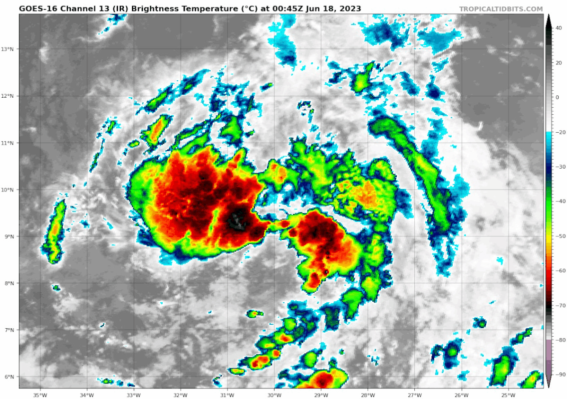
1. LLC appears to be broad and ill defined southwest to northeast. Not really much more organized then it was 12-18 hours ago.
2. Can see some southwesterly shear...Probably ~15 knots.
3. This LLC around is near ~10.5/29.5
4, Convection appears to be west to east along a convergence boundry. This is choking off the LLC from focusing the energy near the center.
I think development of a well defined LLC capable of being upgrading is still at least 24 hours off if not more. Slow strengthening into tropical storm Bret between 24-72 hours before it finally organizes its core to become a strong tropical storm or even a hurricane as it approaches. I think the ridging north of the system along side a lower amount of strengthening will result in this impacting the islands before turning northwest and northward into the Atlantic around 64-65 west. The gfs is will known for punching holes in ridges and so I'd expect it to be well south of the 00z op thinking...

Last edited by Sciencerocks on Sun Jun 18, 2023 1:43 am, edited 5 times in total.
1 likes

Re: ATL: INVEST 92L - Discussion
MetroMike wrote:Does not seem official from what I can see yet
The screenshot is from the old SSD page in 2017 I believe, and seems we could see a rare case of a storm record being broken by another storm of the same name
5 likes
The above post is not official and should not be used as such. It is the opinion of the poster and may or may not be backed by sound meteorological data. It is not endorsed by any professional institution or storm2k.org. For official information, please refer to the NHC and NWS products.
-
weeniepatrol

- Category 5
- Posts: 1345
- Joined: Sat Aug 22, 2020 5:30 pm
- Location: WA State
Re: ATL: INVEST 92L - Discussion
6z TWD:
...SPECIAL FEATURES...
Eastern Tropical Atlantic (AL92): A tropical wave located
several hundred miles SW of the Cabo Verde Islands with axis
near 30W and with a 1011 mb low near 10N29W. The wave axis
extends from 05N to 13N, and is moving W at 15-20 kt. Scattered
moderate convection is observed from 04N to 12N between 27W and
33W. This activity is starting to show some signs of
organization and environmental conditions appear conducive for
additional development.
0 likes
-
weeniepatrol
- Category 5
- Posts: 1345
- Joined: Sat Aug 22, 2020 5:30 pm
- Location: WA State
Re: ATL: INVEST 92L - Discussion
Sciencerocks wrote:2. Can see some southwesterly shear...Probably ~15 knots.
Respectfully, I don't see it at all.
GFS analysis:

Shear is analyzed as 5 kt; we will say 10 kt to be extra super duper generous.
Vorticity:

Vorticity is perfectly vertically aligned/stacked 850 to 500mb. No sign of shear (yet).
Correct me if I am wrong (please).
Last edited by weeniepatrol on Sun Jun 18, 2023 1:37 am, edited 1 time in total.
0 likes
-
NotSparta
- Professional-Met
- Posts: 1677
- Age: 24
- Joined: Fri Aug 18, 2017 8:24 am
- Location: Naples, FL
- Contact:
Re: ATL: INVEST 92L - Discussion
Hammy wrote:MetroMike wrote:Does not seem official from what I can see yet
The screenshot is from the old SSD page in 2017 I believe, and seems we could see a rare case of a storm record being broken by another storm of the same name
Yeah, I was using it as a joke to say Bret will be replaced with Bret
2 likes
This post was probably an opinion of mine, and in no way is official. Please refer to http://www.hurricanes.gov for official tropical analysis and advisories.
My website, with lots of tropical wx graphics, including satellite and recon: http://cyclonicwx.com
My website, with lots of tropical wx graphics, including satellite and recon: http://cyclonicwx.com
-
Sciencerocks
- Category 5
- Posts: 10193
- Age: 40
- Joined: Thu Jul 06, 2017 1:51 am
Re: ATL: INVEST 92L - Discussion
1. The convection that is attempting to blow up over the center is being blown off to the north and northeast of the center....This is suggestive of shear. This shear is also what is providing the convergences for the boundry to the south and southwest of the center.
2. Cimss shear map shows 15-20 knots shear the core....Much higher towards the west.

2. Cimss shear map shows 15-20 knots shear the core....Much higher towards the west.
0 likes
-
NotSparta
- Professional-Met
- Posts: 1677
- Age: 24
- Joined: Fri Aug 18, 2017 8:24 am
- Location: Naples, FL
- Contact:
Re: ATL: INVEST 92L - Discussion
Sciencerocks wrote:1. The convection that is attempting to blow up over the center is being blown off to the north and northeast of the center....This is suggestive of shear. This shear is also what is providing the convergences for the boundry to the south and southwest of the center.
2. Cimss shear map shows 15-20 knots shear the core....Much higher towards the west.
https://imagizer.imageshack.com/img924/935/jV4CKY.gif
On that map, 92L is right inside a low shear zone. Also, those southerly/southwesterly winds aloft aren't too widespread around the system. What we're seeing is more likely outflow on the leading edge of its anticyclone
2 likes
This post was probably an opinion of mine, and in no way is official. Please refer to http://www.hurricanes.gov for official tropical analysis and advisories.
My website, with lots of tropical wx graphics, including satellite and recon: http://cyclonicwx.com
My website, with lots of tropical wx graphics, including satellite and recon: http://cyclonicwx.com
-
weeniepatrol
- Category 5
- Posts: 1345
- Joined: Sat Aug 22, 2020 5:30 pm
- Location: WA State
Re: ATL: INVEST 92L - Discussion
Sciencerocks wrote:1. The convection that is attempting to blow up over the center is being blown off to the north and northeast of the center....This is suggestive of shear. This shear is also what is providing the convergences for the boundry to the south and southwest of the center.
2. Cimss shear map shows 15-20 knots shear the core....Much higher towards the west.

Anticyclonic streamlines over the system is indicative that the analyzed "shear" is simply its own outflow.
There are certainly strong westerlies north/west, however. Currently they are just maintaining a strong poleward outflow
0 likes
-
JetFuel_SE

- Category 1

- Posts: 288
- Age: 26
- Joined: Thu Apr 30, 2020 3:57 pm
Re: ATL: INVEST 92L - Discussion
Sciencerocks wrote:1. The convection that is attempting to blow up over the center is being blown off to the north and northeast of the center....This is suggestive of shear. This shear is also what is providing the convergences for the boundry to the south and southwest of the center.
2. Cimss shear map shows 15-20 knots shear the core....Much higher towards the west.
https://imagizer.imageshack.com/img924/935/jV4CKY.gif
These maps are rarely reliable, as they often confuse outflow with shear.
2 likes
Who is online
Users browsing this forum: No registered users and 76 guests