I said it the other day, if I was in Texas I’d be worried about a hurricane strike sometime in the next few weeks. Not impossible but unlikely that the 12z GFS pans out with a Florida hit from the South. If it was October I’d believe it. Combine that with the fact that Texas has been in drought conditions and are due for a bunch of rain to quench their thirst… Texas needs to keep a close eye to the Southeast.
Sent from my iPhone using Tapatalk
2023 Global Model Runs Discussion (Out thru day 16)
Moderator: S2k Moderators
Forum rules

The posts in this forum are NOT official forecasts and should not be used as such. They are just the opinion of the poster and may or may not be backed by sound meteorological data. They are NOT endorsed by any professional institution or STORM2K. For official information, please refer to products from the National Hurricane Center and National Weather Service.
-
SouthFLTropics

- Category 5

- Posts: 4258
- Age: 50
- Joined: Thu Aug 14, 2003 8:04 am
- Location: Port St. Lucie, Florida
Re: 2023 Global Model Runs Discussion (Out thru day 16)
2 likes
Fourth Generation Florida Native
Personal Storm History: David 79, Andrew 92, Erin 95, Floyd 99, Irene 99, Frances 04, Jeanne 04, Wilma 05, Matthew 16, Irma 17, Ian 22, Nicole 22, Milton 24
Personal Storm History: David 79, Andrew 92, Erin 95, Floyd 99, Irene 99, Frances 04, Jeanne 04, Wilma 05, Matthew 16, Irma 17, Ian 22, Nicole 22, Milton 24


Re: 2023 Global Model Runs Discussion (Out thru day 16)
SouthFLTropics wrote:I said it the other day, if I was in Texas I’d be worried about a hurricane strike sometime in the next few weeks. Not impossible but unlikely that the 12z GFS pans out with a Florida hit from the South. If it was October I’d believe it. Combine that with the fact that Texas has been in drought conditions and are due for a bunch of rain to quench their thirst… Texas needs to keep a close eye to the Southeast.
Sent from my iPhone using Tapatalk
Watching from the upper Texas coast this one.
0 likes
Re: 2023 Global Model Runs Discussion (Out thru day 16)
Looking at the potential upper level pattern towards the middle to end of next week per the GEFS. A lot can change in that time period but it looks like there will be a fairly strong ridge over the CONUS with troughing up in New England and or just off the east coast. If there is a system in the WCAR at that time it might be far enough south that it doesn't feel that trough as much especially if it is weaker than what the 12Z GFS showed. Either way we should keep an eye on this area for development.

0 likes
-
lsuhurricane
- Category 1

- Posts: 270
- Joined: Tue Aug 15, 2017 2:53 pm
Re: 2023 Global Model Runs Discussion (Out thru day 16)
12z Euro still going with a Pacific crossover to the BOC. Interesting look.
2 likes

Re: 2023 Global Model Runs Discussion (Out thru day 16)
GFS and Canadian operational showing a CAG spawned storm approximately 7 days out in roughly the same area. Starting to think these season estimates might not be too far off
0 likes
Re: 2023 Global Model Runs Discussion (Out thru day 16)
The Euro has had a couple runs now showing an EPAC to Atlantic crossover system not to mention there are some EPS members also showing this scenario. This would be a very rare event as I was only able to find 4 systems that have successfully completed the crossover from the EPAC to the Atlantic basin.
Here is a map of the 4 previous EPAC to Atlantic crossovers.

Here is a map of the 4 previous EPAC to Atlantic crossovers.
0 likes
-
lsuhurricane
- Category 1
- Posts: 270
- Joined: Tue Aug 15, 2017 2:53 pm

Possible Development in the GOMEX by the middle of next week
I know this is not the correct thread but we always have the Euro crossover into the Gulf next week 
1 likes
Harvey,Hanna,Beta,Texas Winter storm2021,Nicholas,Beryl
-
cycloneye

- Admin

- Posts: 149686
- Age: 69
- Joined: Thu Oct 10, 2002 10:54 am
- Location: San Juan, Puerto Rico
Re: Possible Development in the GOMEX by the middle of next week
Wampadawg wrote:I know this is not the correct thread but we always have the Euro crossover into the Gulf next week
Moved your post to the correct thread.
1 likes
Visit the Caribbean-Central America Weather Thread where you can find at first post web cams,radars
and observations from Caribbean basin members Click Here
and observations from Caribbean basin members Click Here

Re: 2023 Global Model Runs Discussion (Out thru day 16)
Is it just me or does it seem as if the global models run-to-run inconsistancy is becoming increasingly bad? It seems like it were years ago (perhaps it was) but if/when the EURO began to sniff out tropical development, you just knew that what was being forecast at about 140 hr's was pretty solid. But now, run to run forecasts have seem to become so unbelievably random. And of course it stands to reason why greater "signal" might well be interpreted by focusing more on the ensembles. Ultimately my point has less to do with model accuracy but rather with the question whether our atmosphere is simply becoming more volitile and truly increasingly difficult to understand and forecast?
5 likes
Andy D
(For official information, please refer to the NHC and NWS products.)
(For official information, please refer to the NHC and NWS products.)
-
Stormlover1970
- Tropical Low

- Posts: 32
- Age: 56
- Joined: Sun May 22, 2022 9:26 am
- Location: New Port Richey, Florida
Re: 2023 Global Model Runs Discussion (Out thru day 16)
I agree Mother Nature is angry and these unprecedented events will get worse over timechaser1 wrote:Is it just me or does it seem as if the global models run-to-run inconsistancy is becoming increasingly bad? It seems like it were years ago (perhaps it was) but if/when the EURO began to sniff out tropical development, you just knew that what was being forecast at about 140 hr's was pretty solid. But now, run to run forecasts have seem to become so unbelievably random. And of course it stands to reason why greater "signal" might well be interpreted by focusing more on the ensembles. Ultimately my point has less to do with model accuracy but rather with the question whether our atmosphere is simply becoming more volitile and truly increasingly difficult to understand and forecast?
0 likes
-
Spacecoast

- Category 2

- Posts: 773
- Joined: Thu Aug 31, 2017 2:03 pm
Re: 2023 Global Model Runs Discussion (Out thru day 16)
Happy hour!
Is this even an identified wave?

At least the CAG is gone.
Is this even an identified wave?
At least the CAG is gone.
1 likes
-
SFLcane

- S2K Supporter

- Posts: 10281
- Age: 48
- Joined: Sat Jun 05, 2010 1:44 pm
- Location: Lake Worth Florida
Re: 2023 Global Model Runs Discussion (Out thru day 16)
Spacecoast wrote:Happy hour!
Is this even an identified wave?
https://i.ibb.co/y0FJNvk/gfs-mslp-wind-atl-fh42-288.gif
At least the CAG is gone.
“ and” that interesting wave heading straight west will be gone next run. I have yet to see any real candidates for a developing tc just a bunch of scrambled eggs basin wide. 0 consistency on modeling thus far this season including the once reliable eps.
Last edited by SFLcane on Fri Aug 18, 2023 6:23 pm, edited 1 time in total.
1 likes


Re: 2023 Global Model Runs Discussion (Out thru day 16)
I wouldn't say the models are 'bad'. They're decent up to about 5 days or up to ~120 hours. After that skill decreases across nearly all guidance. Should be viewed for broad signals only. They are also sensitive to moving CCKW/westerly events. There are definitely waves for the models to latch onto, but the conditions crossing ~20N seems to be the barrier currently. The westerly burst just came and went.

0 likes
The above post and any post by Ntxw is NOT an official forecast and should not be used as such. It is just the opinion of the poster and may or may not be backed by sound meteorological data. It is NOT endorsed by any professional institution including Storm2k. For official information, please refer to NWS products.
Help support Storm2K!
-
jlauderdal
- S2K Supporter
- Posts: 7240
- Joined: Wed May 19, 2004 5:46 am
- Location: NE Fort Lauderdale
- Contact:
Re: RE: Re: 2023 Global Model Runs Discussion (Out thru day 16)
Heading right at the shredderSpacecoast wrote:Happy hour!
Is this even an identified wave?
At least the CAG is gone.
1 likes
Re: RE: Re: 2023 Global Model Runs Discussion (Out thru day 16)
jlauderdal wrote:Heading right at the shredderSpacecoast wrote:Happy hour!
Is this even an identified wave?
https://i.ibb.co/y0FJNvk/gfs-mslp-wind-atl-fh42-288.gif
At least the CAG is gone.
It somehow survives that and continues moving west into the gulf. These models are so bipolar and hard to trust at all.
0 likes
-
Blown Away

- S2K Supporter
- Posts: 10253
- Joined: Wed May 26, 2004 6:17 am
Re: RE: Re: 2023 Global Model Runs Discussion (Out thru day 16)
jlauderdal wrote:Heading right at the shredderSpacecoast wrote:Happy hour!
Is this even an identified wave?
https://i.ibb.co/y0FJNvk/gfs-mslp-wind-atl-fh42-288.gif
At least the CAG is gone.
That is top 5 18z GFS Happy Hour run of all time…
0 likes
Hurricane Eye Experience: David 79, Irene 99, Frances 04, Jeanne 04, Wilma 05… Hurricane Brush Experience: Andrew 92, Erin 95, Floyd 99, Matthew 16, Irma 17, Ian 22, Nicole 22…
-
lsuhurricane
- Category 1
- Posts: 270
- Joined: Tue Aug 15, 2017 2:53 pm
Re: 2023 Global Model Runs Discussion (Out thru day 16)
At least the CAG is gone.
Agree, it just doesnt happen that often once peak season rolls around. Wouldnt bet on its dissapearance from future GFS runs though. GEFS still has plenty of CAG based members into the GOM.

0 likes
-
gatorcane

- S2K Supporter
- Posts: 23708
- Age: 48
- Joined: Sun Mar 13, 2005 3:54 pm
- Location: Boca Raton, FL
Re: 2023 Global Model Runs Discussion (Out thru day 16)
SFLcane wrote:Spacecoast wrote:Happy hour!
Is this even an identified wave?
https://i.ibb.co/y0FJNvk/gfs-mslp-wind-atl-fh42-288.gif
At least the CAG is gone.
“ and” that interesting wave heading straight west will be gone next run. I have yet to see any real candidates for a developing tc just a bunch of scrambled eggs basin wide. 0 consistency on modeling thus far this season including the once reliable eps.
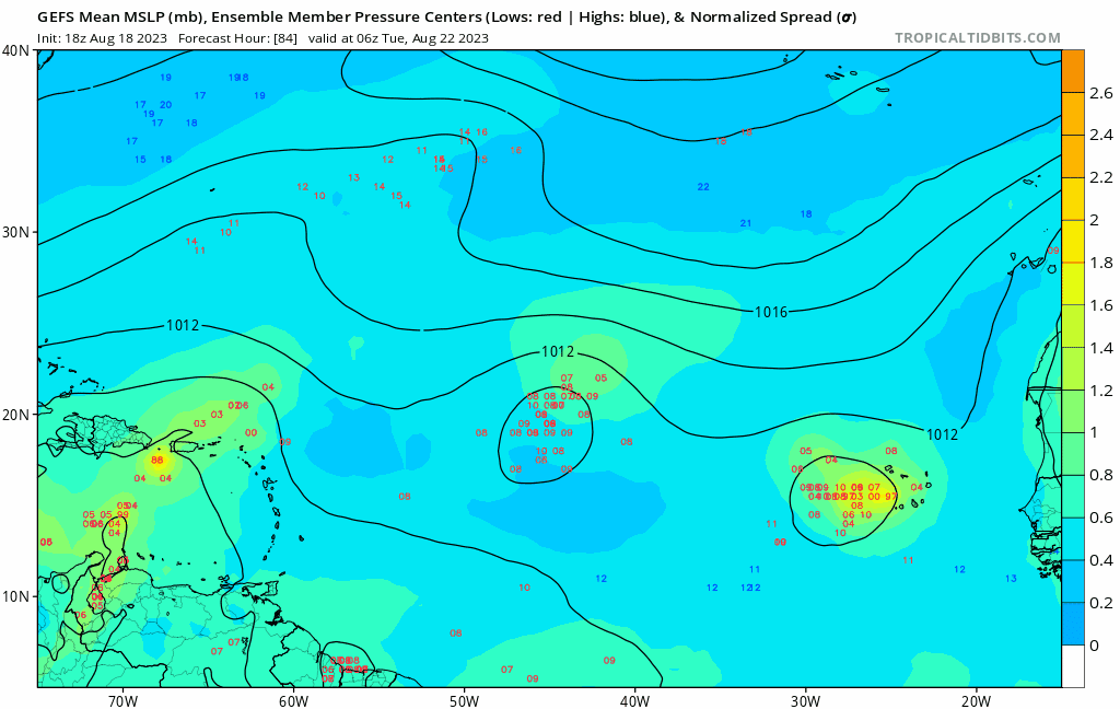
Agree the west runner solution looks highly suspicious. For one thing, the real development doesn’t happen until AFTER 200 hours which is the typical timeframe where the model will spin up a phantom. Secondly, the GEFS shows a quick recurve which looks more likely given the generally weaker than normal Azores ridging this summer so far, not to mention the ECMWF shows a similar recurve albeit without development:
Last edited by gatorcane on Fri Aug 18, 2023 8:34 pm, edited 3 times in total.
0 likes
-
wxman57

- Moderator-Pro Met

- Posts: 23175
- Age: 68
- Joined: Sat Jun 21, 2003 8:06 pm
- Location: Houston, TX (southwest)
Re: 2023 Global Model Runs Discussion (Out thru day 16)
I 100% believe the 384 hr panel of the 18Z GFS. Has to be right THIS time!
5 likes
Who is online
Users browsing this forum: Ulf and 249 guests