2023 Indicators (SST, SAL, MSLP, Wind shear, Steering, Instability) and Day 16+ Models
Moderator: S2k Moderators
Forum rules

The posts in this forum are NOT official forecasts and should not be used as such. They are just the opinion of the poster and may or may not be backed by sound meteorological data. They are NOT endorsed by any professional institution or STORM2K. For official information, please refer to products from the National Hurricane Center and National Weather Service.
Re: 2023 Indicators (SST, SAL, MSLP, Wind shear, Steering, Instability) and Day 16+ Models
Let's hope the Bermuda high continues to be weak for the peak of the season.
0 likes
-
hurricanes1234
- Category 5

- Posts: 2908
- Joined: Sat Jul 28, 2012 6:19 pm
- Location: Trinidad and Tobago
Re: 2023 Indicators (SST, SAL, MSLP, Wind shear, Steering, Instability) and Day 16+ Models
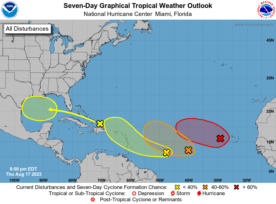
Like clockwork! 
Last week Sunday (Aug 13) vs today (Aug 20):

Last week Sunday (Aug 13) vs today (Aug 20):
11 likes
PLEASE NOTE: With the exception of information from weather agencies that I may copy and paste here, my posts will NEVER be official, since I am NOT a meteorologist. They are solely my amateur opinion, and may or may not be accurate. Therefore, please DO NOT use them as official details, particularly when making important decisions. Thank you.
Re: 2023 Indicators (SST, SAL, MSLP, Wind shear, Steering, Instability) and Day 16+ Models

9 likes
-
jlauderdal
- S2K Supporter

- Posts: 7240
- Joined: Wed May 19, 2004 5:46 am
- Location: NE Fort Lauderdale
- Contact:
Re: RE: Re: 2023 Indicators (SST, SAL, MSLP, Wind shear, Steering, Instability) and Day 16+ Models
And plenty of season cancel posts the last few weeks.hurricanes1234 wrote:Like clockwork!
Last week Sunday (Aug 13) vs today (Aug 20):
5 likes
-
CyclonicFury

- Category 5
- Posts: 2038
- Age: 27
- Joined: Sun Jul 02, 2017 12:32 pm
- Location: NC
- Contact:
Re: 2023 Indicators (SST, SAL, MSLP, Wind shear, Steering, Instability) and Day 16+ Models
I don't think 3 active TCs south of 20N at the same time, including one in the Caribbean, is very Niñoish
4 likes
NCSU B.S. in Meteorology Class of 2021. Tropical weather blogger at http://www.cyclonicfury.com. My forecasts and thoughts are NOT official, for official forecasts please consult the National Hurricane Center.

Re: 2023 Indicators (SST, SAL, MSLP, Wind shear, Steering, Instability) and Day 16+ Models
zzzh wrote:https://i.imgur.com/3KmmCDc.png
And this is the GFS from a week ago. You can't really trust those models 7 days out, especially as peak season starts.
There are no words or graphics that could possibly better drive home the point regarding reasonable inaccuracy of a 7 day global (operational) model forecast. It would be worthwhile to go back and take a similar look at what the ensembles forcast was at the time.
1 likes
Andy D
(For official information, please refer to the NHC and NWS products.)
(For official information, please refer to the NHC and NWS products.)
Re: 2023 Indicators (SST, SAL, MSLP, Wind shear, Steering, Instability) and Day 16+ Models
chaser1 wrote:zzzh wrote:https://i.imgur.com/3KmmCDc.png
There are no words or graphics that could possibly better drive home the point regarding reasonable inaccuracy of a 7 day global (operational) model forecast. It would be worthwhile to go back and take a similar look at what the ensembles forcast was at the time.
The Euro ensemble has been active for most of the runs since August 4th.
1 likes
Personal Forecast Disclaimer:
The posts in this forum are NOT official forecasts and should not be used as such. They are just the opinion of the poster and may or may not be backed by sound meteorological data. They are NOT endorsed by any professional institution or storm2k.org. For official information, please refer to the NHC and NWS products.
The posts in this forum are NOT official forecasts and should not be used as such. They are just the opinion of the poster and may or may not be backed by sound meteorological data. They are NOT endorsed by any professional institution or storm2k.org. For official information, please refer to the NHC and NWS products.
Re: 2023 Indicators (SST, SAL, MSLP, Wind shear, Steering, Instability) and Day 16+ Models
chaser1 wrote:zzzh wrote:https://i.imgur.com/3KmmCDc.png
There are no words or graphics that could possibly better drive home the point regarding reasonable inaccuracy of a 7 day global (operational) model forecast. It would be worthwhile to go back and take a similar look at what the ensembles forcast was at the time.
12Z GEFS from last Sunday. EPS did a much better job of showing an increase in Atlantic activity.

0 likes

Re: 2023 Indicators (SST, SAL, MSLP, Wind shear, Steering, Instability) and Day 16+ Models
IcyTundra wrote:chaser1 wrote:zzzh wrote:https://i.imgur.com/3KmmCDc.png
There are no words or graphics that could possibly better drive home the point regarding reasonable inaccuracy of a 7 day global (operational) model forecast. It would be worthwhile to go back and take a similar look at what the ensembles forcast was at the time.
12Z GEFS from last Sunday. EPS did a much better job of showing an increase in Atlantic activity.
https://i.ibb.co/ykYf7Rq/gfs-ememb-lowlocs-atl-29.png
The GFS/GEFS loves the EPAC, which puts the clamps down on the Atlantic. It’s been that way for a while.
0 likes
Re: 2023 Indicators (SST, SAL, MSLP, Wind shear, Steering, Instability) and Day 16+ Models
CyclonicFury wrote:I don't think 3 active TCs south of 20N at the same time, including one in the Caribbean, is very Niñoish
4 if you count the well organized disturbance in the far E. Atlantic. 5 if you count a potential depression/min storm in the W GOM. Would I call it Nino'ish if none achieved hurricane intensity because each one was sheared into oblivion within 48 hours though? Possibly. Not saying that will occur but upper level shear appears to be a factor with Emily and TD 6
1 likes
Andy D
(For official information, please refer to the NHC and NWS products.)
(For official information, please refer to the NHC and NWS products.)
Re: 2023 Indicators (SST, SAL, MSLP, Wind shear, Steering, Instability) and Day 16+ Models
chaser1 wrote:CyclonicFury wrote:I don't think 3 active TCs south of 20N at the same time, including one in the Caribbean, is very Niñoish
4 if you count the well organized disturbance in the far E. Atlantic. 5 if you count a potential depression/min storm in the W GOM. Would I call it Nino'ish if none achieved hurricane intensity because each one was sheared into oblivion within 48 hours though? Possibly. Not saying that will occur but upper level shear appears to be a factor with Emily and TD 6
To be fair, the upper level conditions can change and the EURO 12Z 7-10 day forecast seems to hint that may occur. Maybe not so Nino'ish after all. Not quite yet anyway.
1 likes
Andy D
(For official information, please refer to the NHC and NWS products.)
(For official information, please refer to the NHC and NWS products.)
-
Category5Kaiju

- Category 5
- Posts: 4346
- Joined: Thu Dec 24, 2020 12:45 pm
- Location: Seattle during the summer, Phoenix during the winter
Re: 2023 Indicators (SST, SAL, MSLP, Wind shear, Steering, Instability) and Day 16+ Models
*Franklin has entered the chat*
It's almost like August 20 is like an important day for the Atlantic, you know?
It's almost like August 20 is like an important day for the Atlantic, you know?
2 likes
Unless explicitly stated, all information in my posts is based on my own opinions and observations. Tropical storms and hurricanes can be extremely dangerous. Refer to an accredited weather research agency or meteorologist if you need to make serious decisions regarding an approaching storm.
-
tolakram
- Admin

- Posts: 20186
- Age: 62
- Joined: Sun Aug 27, 2006 8:23 pm
- Location: Florence, KY (name is Mark)
Re: 2023 Indicators (SST, SAL, MSLP, Wind shear, Steering, Instability) and Day 16+ Models
WiscoWx02 wrote:chaser1 wrote:Teban54 wrote:August 17:
https://i.postimg.cc/wTvW4b9z/two-atl-7d0.png
It's very unlikely to see all 4 develop, and most probably won't get very strong. But still, looks like the switch had been flipped.
That or.........the mid-Atlantic ridge just violently spewed the entire world supply of Skittles
I don’t expect any of the areas to develop to be honest…Atlantic looks about as unfavorable as you can get this time of year with all the shear and dry air.
This aged well.
8 likes
M a r k
- - - - -
Join us in chat: Storm2K Chatroom Invite. Android and IOS apps also available.
The posts in this forum are NOT official forecasts and should not be used as such. Posts are NOT endorsed by any professional institution or STORM2K.org. For official information and forecasts, please refer to NHC and NWS products.
-
SFLcane

- S2K Supporter
- Posts: 10281
- Age: 48
- Joined: Sat Jun 05, 2010 1:44 pm
- Location: Lake Worth Florida
Re: 2023 Indicators (SST, SAL, MSLP, Wind shear, Steering, Instability) and Day 16+ Models
all the absurd talk in early Aug the season is over was ridiculous as always.
Philip k. is on the money.
Philip k. is on the money.
7 likes
Re: 2023 Indicators (SST, SAL, MSLP, Wind shear, Steering, Instability) and Day 16+ Models
This was from a week ago today. Not criticizing the NHC this just goes to show how quickly things can change and that models can't be trusted 7 days out.

3 likes
-
SFLcane
- S2K Supporter
- Posts: 10281
- Age: 48
- Joined: Sat Jun 05, 2010 1:44 pm
- Location: Lake Worth Florida
Re: 2023 Indicators (SST, SAL, MSLP, Wind shear, Steering, Instability) and Day 16+ Models
Last edited by SFLcane on Sun Aug 20, 2023 10:08 pm, edited 3 times in total.
3 likes
-
Spacecoast

- Category 2

- Posts: 773
- Joined: Thu Aug 31, 2017 2:03 pm
Re: 2023 Indicators (SST, SAL, MSLP, Wind shear, Steering, Instability) and Day 16+ Models
LarryWx wrote:chaser1 wrote:zzzh wrote:https://i.imgur.com/3KmmCDc.png
There are no words or graphics that could possibly better drive home the point regarding reasonable inaccuracy of a 7 day global (operational) model forecast. It would be worthwhile to go back and take a similar look at what the ensembles forcast was at the time.
The Euro ensemble has been active for most of the runs since August 4th.
Here's the EPS ensemble run from Aug 15th (couldn't find 7 days).
Five systems were forecast with ~>30% probability for today.
AL91, Franklin,Six, Emily, and AL92 can be seen, albeit bunched together more than observed.

....................................

Don't get me wrong, I think that 7 day forecasts (especially operational), have a very large (>500km) MoE, and subject to genesis errors.
However, the ensembles have given a roughly accurate picture of the range of possibilities.
3 likes
-
SFLcane
- S2K Supporter
- Posts: 10281
- Age: 48
- Joined: Sat Jun 05, 2010 1:44 pm
- Location: Lake Worth Florida
Re: 2023 Indicators (SST, SAL, MSLP, Wind shear, Steering, Instability) and Day 16+ Models
SFLcane wrote:all the absurd talk in early Aug the season is over was ridiculous as always.
Philip k. is on the money.
How is that for the downcasting? Unbelievable stat!
https://twitter.com/michaelrlowry/status/1693452445471387959
3 likes
-
captainbarbossa19

- Professional-Met

- Posts: 1094
- Age: 27
- Joined: Wed Aug 21, 2019 11:09 pm
- Location: Beaumont, TX
Re: 2023 Indicators (SST, SAL, MSLP, Wind shear, Steering, Instability) and Day 16+ Models
SFLcane wrote:SFLcane wrote:all the absurd talk in early Aug the season is over was ridiculous as always.
Philip k. is on the money.
How is that for the downcasting? Unbelievable stat!
https://twitter.com/michaelrlowry/status/1693452445471387959?s=61&t=RqDD5BwXxjs761Eobza7sw
Interesting to note, both of those years had 5 major hurricanes.
2 likes
-
hurricanes1234
- Category 5
- Posts: 2908
- Joined: Sat Jul 28, 2012 6:19 pm
- Location: Trinidad and Tobago
Re: 2023 Indicators (SST, SAL, MSLP, Wind shear, Steering, Instability) and Day 16+ Models
SFLcane wrote:SFLcane wrote:all the absurd talk in early Aug the season is over was ridiculous as always.
Philip k. is on the money.
How is that for the downcasting? Unbelievable stat!
https://twitter.com/michaelrlowry/status/1693452445471387959?s=61&t=RqDD5BwXxjs761Eobza7sw
Yup, and now Tropical Storm Gert has been added to the list of storms which were named in the last 24-30 hours.
0 likes
PLEASE NOTE: With the exception of information from weather agencies that I may copy and paste here, my posts will NEVER be official, since I am NOT a meteorologist. They are solely my amateur opinion, and may or may not be accurate. Therefore, please DO NOT use them as official details, particularly when making important decisions. Thank you.
Who is online
Users browsing this forum: No registered users and 144 guests