Andy Hazelton has posted on Twitter (X) about current Euro and ensembles not weakening low level vortices moving over land and noted the occasional cyclone over Africa. He seems to feel the Pacific MT breaking off a piece that crosses C. America to emerge in the SW aribbean thing is unlucky. PhD met at Hurricane Research Division.
2023 Global Model Runs Discussion (Out thru day 16)
Moderator: S2k Moderators
Forum rules

The posts in this forum are NOT official forecasts and should not be used as such. They are just the opinion of the poster and may or may not be backed by sound meteorological data. They are NOT endorsed by any professional institution or STORM2K. For official information, please refer to products from the National Hurricane Center and National Weather Service.
-
TomballEd
- Category 5

- Posts: 1321
- Age: 62
- Joined: Wed Aug 16, 2023 4:52 pm
- Location: Spring/Klein area, not Tomball
Re: 2023 Global Model Runs Discussion (Out thru day 16)
Andy Hazelton has posted on Twitter (X) about current Euro and ensembles not weakening low level vortices moving over land and noted the occasional cyclone over Africa. He seems to feel the Pacific MT breaking off a piece that crosses C. America to emerge in the SW aribbean thing is unlucky. PhD met at Hurricane Research Division.
3 likes
-
AutoPenalti
- Category 5
- Posts: 4091
- Age: 29
- Joined: Mon Aug 17, 2015 4:16 pm
- Location: Ft. Lauderdale, Florida
Re: 2023 Global Model Runs Discussion (Out thru day 16)
Now THAT'S comedy.
1 likes
The posts in this forum are NOT official forecasts and should not be used as such. They are just the opinion of the poster and may or may not be backed by sound meteorological data. They are NOT endorsed by any professional institution or STORM2K. For official information, please refer to products from the NHC and NWS.
Model Runs Cheat Sheet:
GFS (5:30 AM/PM, 11:30 AM/PM)
HWRF, GFDL, UKMET, NAVGEM (6:30-8:00 AM/PM, 12:30-2:00 AM/PM)
ECMWF (1:45 AM/PM)
TCVN is a weighted averaged
Re: 2023 Global Model Runs Discussion (Out thru day 16)
lsuhurricane wrote:Introducing your 12z EPS run.
https://i.ibb.co/S522Ghm/14-km-EPS-Global-Cyclones-Gulf-of-Mexico-Ens-MSLP-Spaghettios-3.gif
Looks like the big bend will be ground zero. IMO it will shift east some. Already that area of spin and disturbed weather seems a bit more east. Whatever becomes of it will be fluid. we could have hurricane watches for Key west by Sunday night.
0 likes
-
Stratton23
- Category 5
- Posts: 3575
- Joined: Fri Jul 21, 2023 10:59 pm
- Location: Katy, Tx
Re: 2023 Global Model Runs Discussion (Out thru day 16)
Their is no guarantee this is headed to florida and thats evident in the euro ensembles , this could just as easily fizzle out over central america, or get trapped in the BOC, the steering pattern is complicated, lots of variables in play
1 likes

-
Hurricaneman

- Category 5
- Posts: 7404
- Age: 45
- Joined: Tue Aug 31, 2004 3:24 pm
- Location: central florida
Re: 2023 Global Model Runs Discussion (Out thru day 16)
Ianswfl wrote:lsuhurricane wrote:Introducing your 12z EPS run.
https://i.ibb.co/S522Ghm/14-km-EPS-Global-Cyclones-Gulf-of-Mexico-Ens-MSLP-Spaghettios-3.gif
Looks like the big bend will be ground zero. IMO it will shift east some. Already that area of spin and disturbed weather seems a bit more east. Whatever becomes of it will be fluid. we could have hurricane watches for Key west by Sunday night.
Yep, seems to be east of Nicaragua, need to watch that area for development the next few days
0 likes
-
cycloneye

- Admin

- Posts: 149716
- Age: 69
- Joined: Thu Oct 10, 2002 10:54 am
- Location: San Juan, Puerto Rico
Re: 2023 Global Model Runs Discussion (Out thru day 16)
A thread has been made for the area in NW Caribbean. The model runs for that can be posted there.
https://www.storm2k.org/phpbb2/viewtopi ... 4#p3035234
https://www.storm2k.org/phpbb2/viewtopi ... 4#p3035234
0 likes
Visit the Caribbean-Central America Weather Thread where you can find at first post web cams,radars
and observations from Caribbean basin members Click Here
and observations from Caribbean basin members Click Here
-
REDHurricane

- Category 1

- Posts: 438
- Age: 28
- Joined: Sun Jul 03, 2022 2:36 pm
- Location: Northeast Pacific Ocean
-
Blown Away

- S2K Supporter

- Posts: 10253
- Joined: Wed May 26, 2004 6:17 am
Re: 2023 Global Model Runs Discussion (Out thru day 16)
12z ICON... Brings a TS near Sarasota and has a hurricane moving into NE Caribbean.
2 likes
Hurricane Eye Experience: David 79, Irene 99, Frances 04, Jeanne 04, Wilma 05… Hurricane Brush Experience: Andrew 92, Erin 95, Floyd 99, Matthew 16, Irma 17, Ian 22, Nicole 22…
-
Stratton23
- Category 5
- Posts: 3575
- Joined: Fri Jul 21, 2023 10:59 pm
- Location: Katy, Tx
Re: 2023 Global Model Runs Discussion (Out thru day 16)
Might have to keep an eye out on the front that will be steering this system to florida, models showing the front getting out over the gulf of mexico, with the 00z CMC starting to hint at a weak area of low pressure trying to form in the BOC, just something to causally watch, definitely cannot trust even a weak front over the gulf
1 likes
Re: 2023 Global Model Runs Discussion (Out thru day 16)
Stratton23 wrote:Might have to keep an eye out on the front that will be steering this system to florida, models showing the front getting out over the gulf of mexico, with the 00z CMC starting to hint at a weak area of low pressure trying to form in the BOC, just something to causally watch, definitely cannot trust even a weak front over the gulf
Looks like the GFS has a front draping down into the gulf as well.
0 likes
Re: 2023 Global Model Runs Discussion (Out thru day 16)
This is the GFS we all know and love. 00Z develops 3 systems not including the area in the WCAR right now.

3 likes

Re: 2023 Global Model Runs Discussion (Out thru day 16)
384 hr 0z GFS wants September 10, 2023 to be like September 10, 2017 
It even wants them to get the I, J and K names in the exact same order as their 2017 versions too, since GFS still refuses to develop the Caribbean system.
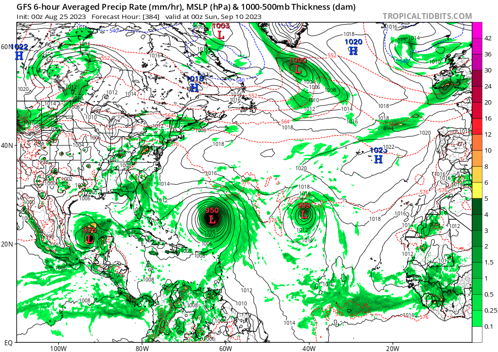
It even wants them to get the I, J and K names in the exact same order as their 2017 versions too, since GFS still refuses to develop the Caribbean system.
1 likes
TC naming lists: retirements and intensity
Most aggressive Advisory #1's in North Atlantic (cr. kevin for starting the list)
Most aggressive Advisory #1's in North Atlantic (cr. kevin for starting the list)
-
jlauderdal
- S2K Supporter
- Posts: 7240
- Joined: Wed May 19, 2004 5:46 am
- Location: NE Fort Lauderdale
- Contact:
Re: 2023 Global Model Runs Discussion (Out thru day 16)
Teban54 wrote:384 hr 0z GFS wants September 10, 2023 to be like September 10, 2017
It even wants them to get the I, J and K names in the exact same order as their 2017 versions too, since GFS still refuses to develop the Caribbean system.
https://i.postimg.cc/QdJzN79T/image.png
The same gfs that cant sniff out the yucatan system a few days in advance
3 likes
Re: 2023 Global Model Runs Discussion (Out thru day 16)
GFS, ECMWF and CMC are in general agreement of a wave leaving Africa on August 29 trying to develop, with some (if not most) runs taking a W to WSW turn past the CV islands.
Eerily similar to another storm at the same time 6 years ago. Let's hope the similarity ends there.
Eerily similar to another storm at the same time 6 years ago. Let's hope the similarity ends there.
2 likes
TC naming lists: retirements and intensity
Most aggressive Advisory #1's in North Atlantic (cr. kevin for starting the list)
Most aggressive Advisory #1's in North Atlantic (cr. kevin for starting the list)
-
ScottNAtlanta

- Category 5
- Posts: 2535
- Joined: Sat May 25, 2013 3:11 pm
- Location: Atlanta, GA
Re: 2023 Global Model Runs Discussion (Out thru day 16)
jlauderdal wrote:Teban54 wrote:384 hr 0z GFS wants September 10, 2023 to be like September 10, 2017
It even wants them to get the I, J and K names in the exact same order as their 2017 versions too, since GFS still refuses to develop the Caribbean system.
https://i.postimg.cc/QdJzN79T/image.png
The same gfs that cant sniff out the yucatan system a few days in advance
Poor GFS...damned when it does, and damned when it doesn't...

3 likes
The posts in this forum are NOT official forecast and should not be used as such. They are just the opinion of the poster and may or may not be backed by sound meteorological data. They are NOT endorsed by any professional institution or storm2k.org. For official information, please refer to the NHC and NWS products.
-
weeniepatrol

- Category 5
- Posts: 1345
- Joined: Sat Aug 22, 2020 5:30 pm
- Location: WA State


-
NotSparta

- Professional-Met

- Posts: 1677
- Age: 24
- Joined: Fri Aug 18, 2017 8:24 am
- Location: Naples, FL
- Contact:
Re: 2023 Global Model Runs Discussion (Out thru day 16)
weeniepatrol wrote:Globals hinting at this wave along 40W amplifying a little. Maybe something else to watch?
https://imgur.com/iNgJy1C
GFS:
https://i.imgur.com/cjivfYG.png
https://imgur.com/k1bdzfx
EC:
https://i.imgur.com/efq1K0H.png
https://imgur.com/H1tgBrT
If it can avoid land it probably has a shot at doing something in the Caribbean. Conditions being modeled there in ~5 days with a wave moving in argue for the possibility of something. Low probability but it is peak season
2 likes
This post was probably an opinion of mine, and in no way is official. Please refer to http://www.hurricanes.gov for official tropical analysis and advisories.
My website, with lots of tropical wx graphics, including satellite and recon: http://cyclonicwx.com
My website, with lots of tropical wx graphics, including satellite and recon: http://cyclonicwx.com
-
ElectricStorm

- Category 5
- Posts: 5155
- Age: 25
- Joined: Tue Aug 13, 2019 11:23 pm
- Location: Norman, OK
Re: 2023 Global Model Runs Discussion (Out thru day 16)
6z GFS gets to 1001mb with that wave in the BOC. Will be interesting to watch over the next several days. Could be a sleeper
0 likes
B.S Meteorology, University of Oklahoma '25
Please refer to the NHC, NWS, or SPC for official information.
Please refer to the NHC, NWS, or SPC for official information.
Re: 2023 Global Model Runs Discussion (Out thru day 16)
Going have to keep an eye on that wave moving into the Caribbean by the middle of next week. Operational GFS has been trending stronger with it.
0 likes
Who is online
Users browsing this forum: AnnularCane, Ntxw, South Texas Storms and 205 guests