ATL: IDALIA - Post-Tropical - Discussion

Moderator: S2k Moderators

Message
Author
User avatar
cheezyWXguy
Category 5
Category 5
Posts: 6108
Joined: Mon Feb 13, 2006 12:29 am
Location: Dallas, TX

Re: ATL: IDALIA - Tropical Storm - Discussion

#741 Postby cheezyWXguy » Sun Aug 27, 2023 3:04 pm

ConvergenceZone wrote:
hohnywx wrote:
ConvergenceZone wrote:
So that means that we probably won't see much strengthening until Tuesday(the day before landfall) then right? because of the shear?


The forecast is available in the NHC discussion

FORECAST POSITIONS AND MAX WINDS

INIT 27/1500Z 19.9N 85.8W 30 KT 35 MPH
12H 28/0000Z 19.7N 85.9W 40 KT 45 MPH
24H 28/1200Z 20.6N 85.7W 45 KT 50 MPH
36H 29/0000Z 21.9N 85.5W 50 KT 60 MPH
48H 29/1200Z 24.0N 85.2W 60 KT 70 MPH
60H 30/0000Z 26.2N 85.0W 75 KT 85 MPH
72H 30/1200Z 28.9N 84.0W 80 KT 90 MPH
96H 31/1200Z 33.0N 79.5W 45 KT 50 MPH...INLAND
120H 01/1200Z 34.5N 74.0W 45 KT 50 MPH...OVER WATER


I think those short-term windspeed numbers COULD be too high initially due to the shear that it's encountering. Perhaps the shear is higher than expected. I still think it will make it to hurricane strength as forecasted, but may take longer than expected to do so. The next 24 hours will be crucial to see if it can hold it's strength....We will see what their next discussion says.

The next 24 hours could help set the stage for how it behaves down the road, but I’m not sure I’d say they’re crucial. Despite the currently accurate descriptor of “sheared mess”, we have a very small and vigorous core here, and I don’t see much to change that in the future, even if this moderate shear persists.

The final 24 hours before landfall are the crucial period, which is what makes this concerning, as conditions should become quite a bit more favorable. With a small tight core like this, the intensity could ramp up quickly near landfall, which could have impacts on track as well. That makes two dimensions in which Florida residents could be caught off guard, and I hope that having Ian still fresh in their minds keeps them on alert.
3 likes   

caneman
Category 5
Category 5
Posts: 1447
Joined: Fri Sep 05, 2014 5:44 am
Location: Clearwater Beach, Fl

Re: RE: Re: ATL: IDALIA - Tropical Storm - Discussion

#742 Postby caneman » Sun Aug 27, 2023 3:04 pm

StormPyrate wrote:
caneman wrote:
robbielyn wrote:
I also think we r at a wait and see here in tampabay area. We r aware, we may get some water gas up, but until we know where it’s going, we hv a ok that’s what they said last year attitude and until sw fl or pc is out of the picture, we aren’t 100% sure it’s really coming here. I am 98% prepared but leaving the 2% until I see what Idalia is going to do. By tomorrow i’ll know and finish it before tuesday.


Many are in a wait and see mode here On the beaches of Pinellas. We've dealt with many high end t.s. and wind gusts Cat. 1 storms. We've had too many major close calls to panic. That could possibly lead to complacency and certainly many have got burnt out. It will ramp up though as we get closer and if more than a Cat. 1


Sams Clube on gulf to bay was crazy this morning with people stocking up


I've seen activity but nobody going crazy. Still slow at the gas pumps. There will be some in for a rude awakening tomorrow morning and having to go to work while realizing they're not prepared
0 likes   

User avatar
chaser1
S2K Supporter
S2K Supporter
Posts: 5467
Age: 64
Joined: Sat Oct 15, 2005 5:59 pm
Location: Longwood, Fl

Re: ATL: IDALIA - Tropical Storm - Discussion

#743 Postby chaser1 » Sun Aug 27, 2023 3:09 pm

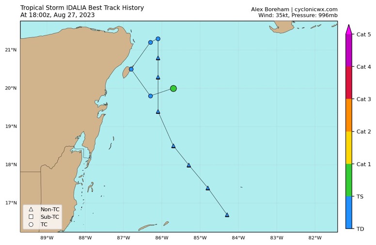
Ian2401 wrote:Something interesting I just noticed. 15z advisory from NHC said that 12hrs from then (11pm edt), Idalia would actually lose 0.3 deg of latitude, going down to 19.7N. However per the NHC (and viewing visible imagery) the center is parked at 20.0N and moving N at 2mph. Curious to see if / how this affects anything.

or maybe I just really need to stop wobble watching lol


You're correct on all three points. I believe that some models even suggested the storm making another small cyclonic loop, however it does appear basically stationary to me to. About to give my eyes and brain a rest as well LOL
0 likes   
Andy D

(For official information, please refer to the NHC and NWS products.)

User avatar
Bocadude85
Category 5
Category 5
Posts: 2991
Age: 38
Joined: Mon Apr 18, 2005 2:20 pm
Location: Honolulu,Hi

Re: ATL: IDALIA - Tropical Storm - Discussion

#744 Postby Bocadude85 » Sun Aug 27, 2023 3:10 pm

I’m doubtful this landfalls in the Big Bend as a hurricane, Tampa Bays luck may finally be up. Wouldn’t be surprised to see this come in south of Tampa either. Almost all storms approaching the west coast of Florida with an easterly component to their track have ended up landfalling further south and east. Ian, Irma, Charley to name a few.
4 likes   

User avatar
robbielyn
Category 5
Category 5
Posts: 1298
Joined: Wed May 07, 2003 9:45 am
Location: brooksville, fl

Re: ATL: IDALIA - Tropical Storm - Discussion

#745 Postby robbielyn » Sun Aug 27, 2023 3:13 pm

Bocadude85 wrote:I’m doubtful this landfalls in the Big Bend as a hurricane, Tampa Bays luck may finally be up. Wouldn’t be surprised to see this come in south of Tampa either. Almost all storms approaching the west coast of Florida with an easterly component to their track have ended up landfalling further south and east. Ian, Irma, Charley to name a few.


True dat but wonder how having Franklin so close might keep Idalia from hitting sw florida.
0 likes   
Robbielyn McCrary
I know just about enough to sound like I know what I'm talking about sometimes. But for your safety please follow the nhc for truly professional forecasting. :D

Sciencerocks
Category 5
Category 5
Posts: 9155
Age: 39
Joined: Thu Jul 06, 2017 1:51 am

Re: ATL: IDALIA - Tropical Storm - Discussion

#746 Postby Sciencerocks » Sun Aug 27, 2023 3:20 pm

Image
0 likes   

User avatar
chaser1
S2K Supporter
S2K Supporter
Posts: 5467
Age: 64
Joined: Sat Oct 15, 2005 5:59 pm
Location: Longwood, Fl

Re: ATL: IDALIA - Tropical Storm - Discussion

#747 Postby chaser1 » Sun Aug 27, 2023 3:23 pm

GFS clearly indicating an increased change in total precip forecast for Sarasota to Clearwater from prior 0Z and 6Z, to now depicting 2-4" on it's 12Z run. I can see that area expanding as well
1 likes   
Andy D

(For official information, please refer to the NHC and NWS products.)

norva13x
Tropical Storm
Tropical Storm
Posts: 102
Joined: Fri Sep 01, 2017 10:41 am

Re: ATL: IDALIA - Tropical Storm - Discussion

#748 Postby norva13x » Sun Aug 27, 2023 3:24 pm

Are we going to be getting watches and warnings tonight in Florida you think?
0 likes   

User avatar
chaser1
S2K Supporter
S2K Supporter
Posts: 5467
Age: 64
Joined: Sat Oct 15, 2005 5:59 pm
Location: Longwood, Fl

Re: ATL: IDALIA - Tropical Storm - Discussion

#749 Postby chaser1 » Sun Aug 27, 2023 3:25 pm

norva13x wrote:Are we going to be getting watches and warnings tonight in Florida you think?


Yep, i think they'll have to. If not at 5:00, then at 11:00
2 likes   
Andy D

(For official information, please refer to the NHC and NWS products.)

User avatar
weeniepatrol
Category 5
Category 5
Posts: 1276
Joined: Sat Aug 22, 2020 5:30 pm
Location: WA State

Re: ATL: IDALIA - Tropical Storm - Discussion

#750 Postby weeniepatrol » Sun Aug 27, 2023 3:26 pm


Beautiful inflow / surface convergence into Idalia
1 likes   

User avatar
Blown Away
S2K Supporter
S2K Supporter
Posts: 10146
Joined: Wed May 26, 2004 6:17 am

Re: ATL: IDALIA - Tropical Storm - Discussion

#751 Postby Blown Away » Sun Aug 27, 2023 3:28 pm

The anticipated recon factor in the upcoming model runs has been anticlimactic over the past few years. :D
10 likes   
Hurricane Eye Experience: David 79, Irene 99, Frances 04, Jeanne 04, Wilma 05... EYE COMING MY WAY IN 2024…
Hurricane Brush Experience: Andrew 92, Erin 95, Floyd 99, Matthew 16, Irma 17, Ian 22, Nicole 22…

Chemmers
Tropical Storm
Tropical Storm
Posts: 220
Joined: Wed Jul 22, 2020 6:16 am

Re: ATL: IDALIA - Tropical Storm - Discussion

#752 Postby Chemmers » Sun Aug 27, 2023 3:32 pm

Hot towers showering up on the feeder band now, think by dusk we might see some hot towers in the COC?
1 likes   

Ian2401
Category 1
Category 1
Posts: 307
Joined: Thu Sep 14, 2017 5:55 pm
Location: Tallahassee, Florida
Contact:

Re: ATL: IDALIA - Tropical Storm - Discussion

#753 Postby Ian2401 » Sun Aug 27, 2023 3:32 pm

chaser1 wrote:
Ian2401 wrote:Something interesting I just noticed. 15z advisory from NHC said that 12hrs from then (11pm edt), Idalia would actually lose 0.3 deg of latitude, going down to 19.7N. However per the NHC (and viewing visible imagery) the center is parked at 20.0N and moving N at 2mph. Curious to see if / how this affects anything.

or maybe I just really need to stop wobble watching lol


You're correct on all three points. I believe that some models even suggested the storm making another small cyclonic loop, however it does appear basically stationary to me to. About to give my eyes and brain a rest as well LOL

You're correct on the cyclonic loop. Majority of the most recent EPS ensembles (12z) show a brief dive to the SW, then a brief Eastward nudge, then shooting North. I believe GEFS ensembles also show it, but dont hold me to that. Not seeing that happen yet but I do see some strong convection going up South of the LLC so maybe that will induce the loop (that rhymes!).
0 likes   
B.S. Meteorology from Florida State '24 // Current M.S. Meteorology student at Florida State

Research Interests: Rapid Intensification, TC Climatology, TC Modeling

Consult the NHC for official information

Mob1
Tropical Low
Tropical Low
Posts: 32
Joined: Sun Jun 07, 2020 11:03 am

Re: ATL: IDALIA - Tropical Storm - Discussion

#754 Postby Mob1 » Sun Aug 27, 2023 3:32 pm

Blown Away wrote:The anticipated recon factor in the upcoming model runs has been anticlimactic over the past few years. :D


Models have gotten pretty good over the years and for the most part even when you get a true center (not always the case in early stages of developing storms) the shifts are still fairly minor.

The days of wholesale changes (at least in the short term) due to recon data are behind us. Obviously for some people minor changes in the track can make a big difference, but it's not 1987 when ingesting recon data could move a storm from New Orleans to Miami.
1 likes   

jlauderdal
S2K Supporter
S2K Supporter
Posts: 7183
Joined: Wed May 19, 2004 5:46 am
Location: NE Fort Lauderdale
Contact:

Re: RE: Re: ATL: IDALIA - Tropical Storm - Discussion

#755 Postby jlauderdal » Sun Aug 27, 2023 3:33 pm

Blown Away wrote:The anticipated recon factor in the upcoming model runs has been anticlimactic over the past few years. :D
12 missions tomorrow so that might help. Or maybe its data overload.
1 likes   

User avatar
chaser1
S2K Supporter
S2K Supporter
Posts: 5467
Age: 64
Joined: Sat Oct 15, 2005 5:59 pm
Location: Longwood, Fl

Re: ATL: IDALIA - Tropical Storm - Discussion

#756 Postby chaser1 » Sun Aug 27, 2023 3:38 pm

Because the 4:00pm (Central) is when the next update comes out and this being prior to much of the 18Z model runs, I think that NHC might start with TS Watches put out for coastal areas from as far south as Venice to points northward initially and with Warnings hoisted for points northward later tonight.
1 likes   
Andy D

(For official information, please refer to the NHC and NWS products.)

User avatar
SouthernBreeze
Category 1
Category 1
Posts: 284
Age: 68
Joined: Tue Aug 31, 2004 4:54 pm
Location: SC/NC line- on the SC Coast

Re: ATL: IDALIA - Tropical Storm - Discussion

#757 Postby SouthernBreeze » Sun Aug 27, 2023 3:40 pm

Has anyone here noticed this site? There are a lot of different settings when you click the word 'earth' at lower left. I find it quite mesmerizing to watch the air & ocean currents flow at some of the settings, but I don't know how up-to-date & accurate it is.

https://earth.nullschool.net/#current/wind/isobaric/500hPa/patterson=-69.85,22.52,984
0 likes   
My posts are NOT official forecast and should not be used as such. It's just my opinion and not backed by sound meteorological data, and NOT endorsed by any professional institution or storm2k.org. For official information, please refer to the NHC and NWS products.

grazed by many - most wind damage: Hugo (pre-cellphone days!) & most water: Floyd

User avatar
johngaltfla
Category 5
Category 5
Posts: 2069
Joined: Sun Jul 10, 2005 9:17 pm
Location: Sarasota County, FL
Contact:

Re: ATL: IDALIA - Tropical Storm - Discussion

#758 Postby johngaltfla » Sun Aug 27, 2023 3:41 pm

chaser1 wrote:Because the 4:00pm (Central) is when the next update comes out and this being prior to much of the 18Z model runs, I think that NHC might start with TS Watches put out for coastal areas from as far south as Venice to points northward initially and with Warnings hoisted for points northward later tonight.


I just want to see the 18 & 0000Z model output. The positioning of this system is very dangerous to the West Coast of Florida and can not be underestimated.
4 likes   

caneman
Category 5
Category 5
Posts: 1447
Joined: Fri Sep 05, 2014 5:44 am
Location: Clearwater Beach, Fl

Re: ATL: IDALIA - Tropical Storm - Discussion

#759 Postby caneman » Sun Aug 27, 2023 3:42 pm

johngaltfla wrote:
chaser1 wrote:Because the 4:00pm (Central) is when the next update comes out and this being prior to much of the 18Z model runs, I think that NHC might start with TS Watches put out for coastal areas from as far south as Venice to points northward initially and with Warnings hoisted for points northward later tonight.


I just want to see the 18 & 0000Z model output. The positioning of this system is very dangerous to the West Coast of Florida and can not be underestimated.


100%
2 likes   

User avatar
SFLcane
S2K Supporter
S2K Supporter
Posts: 10163
Age: 47
Joined: Sat Jun 05, 2010 1:44 pm
Location: Lake Worth Florida

Re: ATL: IDALIA - Tropical Storm - Discussion

#760 Postby SFLcane » Sun Aug 27, 2023 3:47 pm

Image

Image
5 likes   


Return to “2023”

Who is online

Users browsing this forum: No registered users and 1 guest