
ATL: IDALIA - Models
Moderator: S2k Moderators

Re: ATL: IDALIA - Models
otowntiger wrote:.Ivanhater wrote:gatorcane wrote:
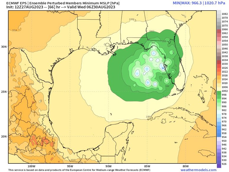
I don’t believe that has the latest Euro run yet as it hasn’t finished running?
The Euro is still very close to the blend. Big bend
Agreed. I think the time has come that any big shifts in the official forecast are over. Minor tweaks right or left from this point forward are likely all we’ll see, in just my humble non met opinion of course.
Also speaking as a non met, but I do think the 18z model has potential for a shift but after that I agree it'll be fairly locked in. In my experience the three day come is usually pretty accurate, the the 2 and 1 day forecasts very much so (at least concerning track). Intensity is still a bit of a toss up.
2 likes
Re: ATL: IDALIA - Models
SFLcane wrote:As far south as Fort Myers now. Huge spread
https://i.postimg.cc/sgs01N4V/IMG-7519.jpg
More tight than 06z but more east weighted too
0 likes


Re: ATL: IDALIA - Models
norva13x wrote:otowntiger wrote:.Ivanhater wrote:
The Euro is still very close to the blend. Big bend
Agreed. I think the time has come that any big shifts in the official forecast are over. Minor tweaks right or left from this point forward are likely all we’ll see, in just my humble non met opinion of course.
Also speaking as a non met, but I do think the 18z model has potential for a shift but after that I agree it'll be fairly locked in. In my experience the three day come is usually pretty accurate, the the 2 and 1 day forecasts very much so (at least concerning track). Intensity is still a bit of a toss up.
It wasn’t accurate in the 3 day cone with Ian.
1 likes
Robbielyn McCrary
I know just about enough to sound like I know what I'm talking about sometimes. But for your safety please follow the nhc for truly professional forecasting.
I know just about enough to sound like I know what I'm talking about sometimes. But for your safety please follow the nhc for truly professional forecasting.
Re: ATL: IDALIA - Models
robbielyn wrote:norva13x wrote:otowntiger wrote:.
Agreed. I think the time has come that any big shifts in the official forecast are over. Minor tweaks right or left from this point forward are likely all we’ll see, in just my humble non met opinion of course.
Also speaking as a non met, but I do think the 18z model has potential for a shift but after that I agree it'll be fairly locked in. In my experience the three day come is usually pretty accurate, the the 2 and 1 day forecasts very much so (at least concerning track). Intensity is still a bit of a toss up.
It wasn’t accurate in the 3 day cone with Ian.
That's very true, I suppose only time will tell. My hope at least is that it doesn't blow up before hitting, fingers crossed.
0 likes

Re: ATL: IDALIA - Models
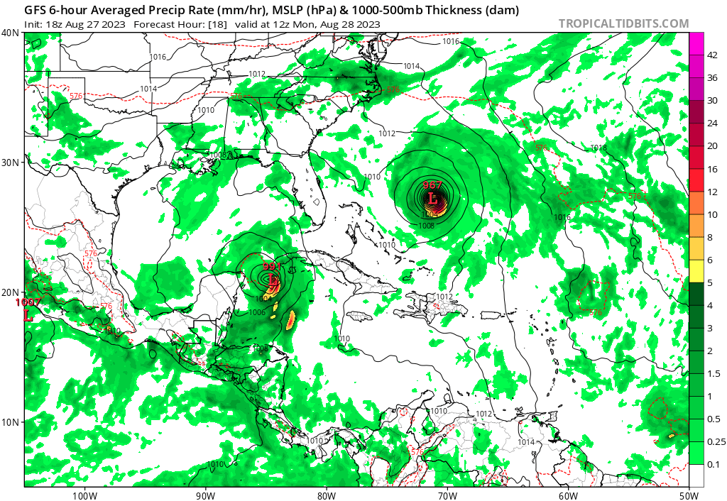
Ians projected track three days from landfall and 24 hours later. Obviously not the exact situation as it is coming from the west but its just a reminder that these types of things are fluid. Just because models are latching onto an idea doesn't mean it will 100% verify. Always be prepared if you are anywhere near the cone.


4 likes
-
tolakram
- Admin

- Posts: 20179
- Age: 62
- Joined: Sun Aug 27, 2006 8:23 pm
- Location: Florence, KY (name is Mark)
Re: ATL: IDALIA - Models
Be careful not to fight the last battle. It's really easy to expect a storm to do what the last one did and get burned. It's fun an interesting, but expect to be surprised.

8 likes
M a r k
- - - - -
Join us in chat: Storm2K Chatroom Invite. Android and IOS apps also available.
The posts in this forum are NOT official forecasts and should not be used as such. Posts are NOT endorsed by any professional institution or STORM2K.org. For official information and forecasts, please refer to NHC and NWS products.
Re: ATL: IDALIA - Models
tolakram wrote:Be careful not to fight the last battle. It's really easy to expect a storm to do what the last one did and get burned. It's fun an interesting, but expect to be surprised.
https://i.imgur.com/VAawrxi.png
True that...Idalia looks to be an equal opportunity impacts/ rainmaker for a large area of the Florida peninsula, as well as points Northward unfortunately....
1 likes

Re: ATL: IDALIA - Models
jfk08c wrote:Ians projected track three days from landfall and 24 hours later. Obviously not the exact situation as it is coming from the west but its just a reminder that these types of things are fluid. Just because models are latching onto an idea doesn't mean it will 100% verify. Always be prepared if you are anywhere near the cone.
Absolutely true, but a careful look at the two tracks in the Tampa area only show what, about a 30 mile longitudinal shift? Even 3 days out the track was darned good.
0 likes
I'm not a meteorologist, I'm an electronics engineer. While I can probably fix your toaster oven, you're not going to learn about storms from me!
New Mexico had no hurricanes. Then I moved to NC right before Fran.....
New Mexico had no hurricanes. Then I moved to NC right before Fran.....

Re: ATL: IDALIA - Models
Pretty significant shift for Tampa and Jacksonville.
1 likes
The following post is NOT an official forecast and should not be used as such. It is just the opinion of the poster and may or may not be backed by sound meteorological data. It is NOT endorsed by any professional institution including storm2k.org For Official Information please refer to the NHC and NWS products.

-
gatorcane

- S2K Supporter

- Posts: 23708
- Age: 48
- Joined: Sun Mar 13, 2005 3:54 pm
- Location: Boca Raton, FL
Re: ATL: IDALIA - Models
IcyTundra wrote:18Z GFS now running
Already east of the 12Z at 6 hours.
Last edited by gatorcane on Sun Aug 27, 2023 4:38 pm, edited 1 time in total.
0 likes
Re: ATL: IDALIA - Models
Models coming together nicely. I'd go with Hernando County for landfall. Depending on the size though entire SWFL coast on up could have 80-90mph gusts.
0 likes
-
tolakram
- Admin
- Posts: 20179
- Age: 62
- Joined: Sun Aug 27, 2006 8:23 pm
- Location: Florence, KY (name is Mark)
Re: ATL: IDALIA - Models
18Z started

0 likes
M a r k
- - - - -
Join us in chat: Storm2K Chatroom Invite. Android and IOS apps also available.
The posts in this forum are NOT official forecasts and should not be used as such. Posts are NOT endorsed by any professional institution or STORM2K.org. For official information and forecasts, please refer to NHC and NWS products.
- - - - -
Join us in chat: Storm2K Chatroom Invite. Android and IOS apps also available.
The posts in this forum are NOT official forecasts and should not be used as such. Posts are NOT endorsed by any professional institution or STORM2K.org. For official information and forecasts, please refer to NHC and NWS products.
-
tolakram
- Admin
- Posts: 20179
- Age: 62
- Joined: Sun Aug 27, 2006 8:23 pm
- Location: Florence, KY (name is Mark)
Re: ATL: IDALIA - Models

0 likes
M a r k
- - - - -
Join us in chat: Storm2K Chatroom Invite. Android and IOS apps also available.
The posts in this forum are NOT official forecasts and should not be used as such. Posts are NOT endorsed by any professional institution or STORM2K.org. For official information and forecasts, please refer to NHC and NWS products.
- - - - -
Join us in chat: Storm2K Chatroom Invite. Android and IOS apps also available.
The posts in this forum are NOT official forecasts and should not be used as such. Posts are NOT endorsed by any professional institution or STORM2K.org. For official information and forecasts, please refer to NHC and NWS products.
-
gatorcane
- S2K Supporter
- Posts: 23708
- Age: 48
- Joined: Sun Mar 13, 2005 3:54 pm
- Location: Boca Raton, FL
Re: ATL: IDALIA - Models
18Z GFS getting close to the Western tip of Cuba
Last edited by gatorcane on Sun Aug 27, 2023 4:41 pm, edited 1 time in total.
0 likes
-
skillz305
- Category 1

- Posts: 312
- Joined: Sat Sep 08, 2018 11:10 am
- Location: Miami, Florida --> Vero Beach, Florida
Re: ATL: IDALIA - Models
18z GFS at 18 hour wowwww
0 likes
 Hurricanes: Andrew 1992 - Irene 1999 - Frances 2004 - Jeanne 2004 - Katrina 2005 - Wilma 2005 - Matthew 2016 - Irma 2017 - Ian 2022 - Nicole 2022 - Milton 2024
-
tolakram
- Admin
- Posts: 20179
- Age: 62
- Joined: Sun Aug 27, 2006 8:23 pm
- Location: Florence, KY (name is Mark)
Re: ATL: IDALIA - Models

0 likes
M a r k
- - - - -
Join us in chat: Storm2K Chatroom Invite. Android and IOS apps also available.
The posts in this forum are NOT official forecasts and should not be used as such. Posts are NOT endorsed by any professional institution or STORM2K.org. For official information and forecasts, please refer to NHC and NWS products.
- - - - -
Join us in chat: Storm2K Chatroom Invite. Android and IOS apps also available.
The posts in this forum are NOT official forecasts and should not be used as such. Posts are NOT endorsed by any professional institution or STORM2K.org. For official information and forecasts, please refer to NHC and NWS products.
-
gatorcane
- S2K Supporter
- Posts: 23708
- Age: 48
- Joined: Sun Mar 13, 2005 3:54 pm
- Location: Boca Raton, FL
Re: ATL: IDALIA - Models
tolakram wrote:https://i.imgur.com/ser0ev9.png
Again a notable shift to the east by the GFS even at this short-range.
Last edited by gatorcane on Sun Aug 27, 2023 4:44 pm, edited 1 time in total.
0 likes
Who is online
Users browsing this forum: No registered users and 43 guests