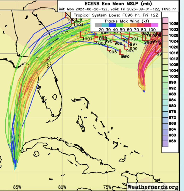
ATL: IDALIA - Models

Moderator: S2k Moderators

Message
Author
User avatar
Blown Away
S2K Supporter
S2K Supporter
Posts: 10140
Joined: Wed May 26, 2004 6:17 am

Re: ATL: IDALIA - Models

#781 Postby Blown Away » Mon Aug 28, 2023 3:13 pm

gatorcane wrote:
chris_fit wrote:
gatorcane wrote:Looks like the EPS has shifted to the east a bit with the stronger members on the east side landfalling around Cedar Key:

https://i.postimg.cc/bJSRtMpr/IMG-0891.png


There's no need to bring this kind of negativity here.... We were doing swell with the west shifts.


Can you post the zoomed in view with the mean track?


Image
1 likes   
Hurricane Eye Experience: David 79, Irene 99, Frances 04, Jeanne 04, Wilma 05... EYE COMING MY WAY IN 2024…
Hurricane Brush Experience: Andrew 92, Erin 95, Floyd 99, Matthew 16, Irma 17, Ian 22, Nicole 22…

User avatar
cycloneye
Admin
Admin
Posts: 143869
Age: 68
Joined: Thu Oct 10, 2002 10:54 am
Location: San Juan, Puerto Rico

Re: ATL: IDALIA - Models

#782 Postby cycloneye » Mon Aug 28, 2023 3:17 pm

3 likes   
Visit the Caribbean-Central America Weather Thread where you can find at first post web cams,radars
and observations from Caribbean basin members Click Here

User avatar
gatorcane
S2K Supporter
S2K Supporter
Posts: 23689
Age: 47
Joined: Sun Mar 13, 2005 3:54 pm
Location: Boca Raton, FL

Re: ATL: IDALIA - Models

#783 Postby gatorcane » Mon Aug 28, 2023 3:17 pm

Blown Away wrote:
gatorcane wrote:
chris_fit wrote:
There's no need to bring this kind of negativity here.... We were doing swell with the west shifts.


Can you post the zoomed in view with the mean track?


[url]https://i.postimg.cc/y8Fd2Zht/65-FA6-E75-D062-4619-8-C0-F-6558-E49-CC182.jpg [/url]


Tampa area will get some rough weather with those eastern tracks.
4 likes   

caneman
Category 5
Category 5
Posts: 1446
Joined: Fri Sep 05, 2014 5:44 am
Location: Clearwater Beach, Fl

Re: ATL: IDALIA - Models

#784 Postby caneman » Mon Aug 28, 2023 3:23 pm

gatorcane wrote:
Blown Away wrote:
gatorcane wrote:
Can you post the zoomed in view with the mean track?


[url]https://i.postimg.cc/y8Fd2Zht/65-FA6-E75-D062-4619-8-C0-F-6558-E49-CC182.jpg [/url]


Tampa area will get some rough weather with those eastern tracks.


For sure. I hope they would keep us in the cone based on this. Do they give a lot of weight to the ensembles?
0 likes   

Ianswfl
Category 1
Category 1
Posts: 482
Joined: Thu Mar 23, 2023 11:11 pm

Re: ATL: IDALIA - Models

#785 Postby Ianswfl » Mon Aug 28, 2023 3:42 pm

The ensembles suggesting this pulls an Ivan and heads back west! One european ensemble has a hurricane Idalia coming back around and heading for the Bahamas! :eek:
0 likes   

User avatar
Blown Away
S2K Supporter
S2K Supporter
Posts: 10140
Joined: Wed May 26, 2004 6:17 am

Re: ATL: IDALIA - Models

#786 Postby Blown Away » Mon Aug 28, 2023 4:08 pm

Image

18z ICON… Decent W shift at landfall.
1 likes   
Hurricane Eye Experience: David 79, Irene 99, Frances 04, Jeanne 04, Wilma 05... EYE COMING MY WAY IN 2024…
Hurricane Brush Experience: Andrew 92, Erin 95, Floyd 99, Matthew 16, Irma 17, Ian 22, Nicole 22…

tolakram
Admin
Admin
Posts: 19990
Age: 61
Joined: Sun Aug 27, 2006 8:23 pm
Location: Florence, KY (name is Mark)

Re: ATL: IDALIA - Models

#787 Postby tolakram » Mon Aug 28, 2023 4:13 pm

ICON trend
Image
1 likes   
M a r k
- - - - -
Join us in chat: Storm2K Chatroom Invite. Android and IOS apps also available.

The posts in this forum are NOT official forecasts and should not be used as such. Posts are NOT endorsed by any professional institution or STORM2K.org. For official information and forecasts, please refer to NHC and NWS products.

User avatar
Nimbus
Category 5
Category 5
Posts: 5274
Joined: Mon Jul 19, 2004 10:54 am

Re: ATL: IDALIA - Models

#788 Postby Nimbus » Mon Aug 28, 2023 4:32 pm

gatorcane wrote:
Blown Away wrote:
gatorcane wrote:
Can you post the zoomed in view with the mean track?


[url]https://i.postimg.cc/y8Fd2Zht/65-FA6-E75-D062-4619-8-C0-F-6558-E49-CC182.jpg [/url]


Tampa area will get some rough weather with those eastern tracks.


The official track from tonights 5 PM NHC discussion has thec enter only a couple degrees west of St Petersburg.
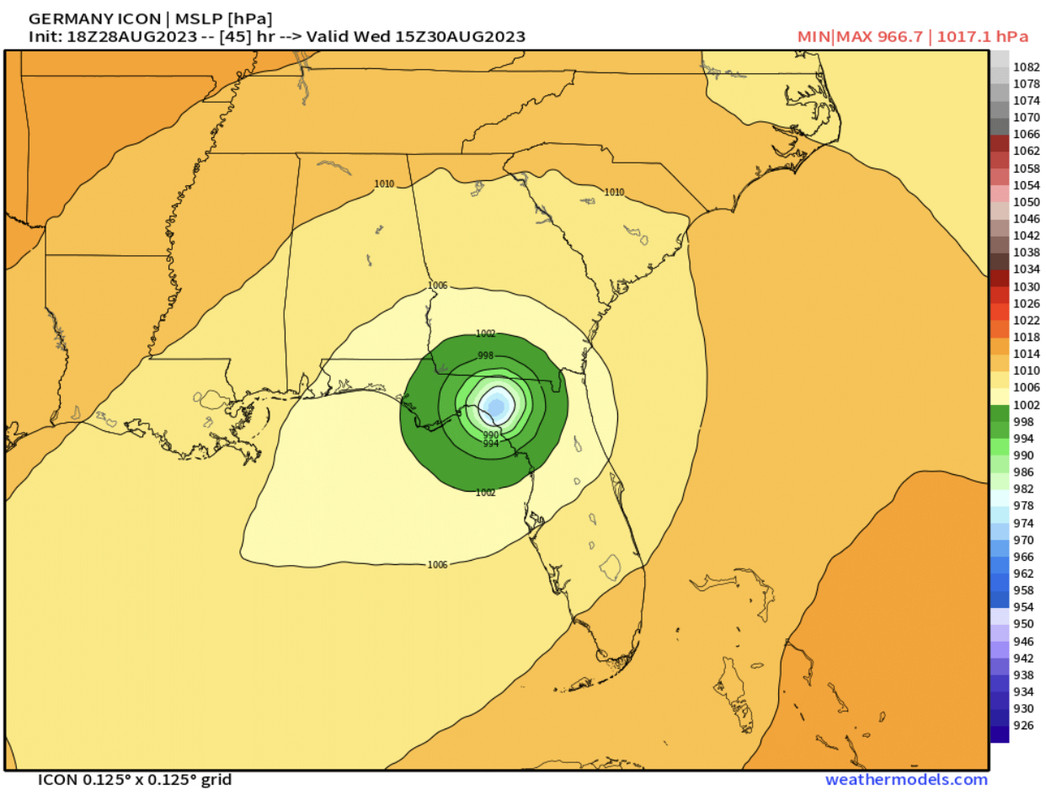
36H 30/0600Z 27.6N 84.4W 105 KT 120 MPH

Every storm is different but northeastern quadrant of a major hurricane often has tropical storm winds that take out power some distance from the center.

But that is just the Tampa bay area, much more concerned about Tallahassee and Jacksonville and the cities impacted further north. Prep day tomorrow for them, generator and shutter decisions for the high and dry and evacuations for anyone close to water.
2 likes   

User avatar
NDG
S2K Supporter
S2K Supporter
Posts: 15446
Joined: Sun Jul 09, 2006 10:14 pm
Location: Orlando, FL

Re: ATL: IDALIA - Models

#789 Postby NDG » Mon Aug 28, 2023 4:44 pm

Wow, 18z GFS shows not much strengthening over the next 24 hrs.
1 likes   

tolakram
Admin
Admin
Posts: 19990
Age: 61
Joined: Sun Aug 27, 2006 8:23 pm
Location: Florence, KY (name is Mark)

Re: ATL: IDALIA - Models

#790 Postby tolakram » Mon Aug 28, 2023 4:46 pm

Image
0 likes   
M a r k
- - - - -
Join us in chat: Storm2K Chatroom Invite. Android and IOS apps also available.

The posts in this forum are NOT official forecasts and should not be used as such. Posts are NOT endorsed by any professional institution or STORM2K.org. For official information and forecasts, please refer to NHC and NWS products.

tolakram
Admin
Admin
Posts: 19990
Age: 61
Joined: Sun Aug 27, 2006 8:23 pm
Location: Florence, KY (name is Mark)

Re: ATL: IDALIA - Models

#791 Postby tolakram » Mon Aug 28, 2023 4:47 pm

Image
0 likes   
M a r k
- - - - -
Join us in chat: Storm2K Chatroom Invite. Android and IOS apps also available.

The posts in this forum are NOT official forecasts and should not be used as such. Posts are NOT endorsed by any professional institution or STORM2K.org. For official information and forecasts, please refer to NHC and NWS products.

PavelGaborik10
Category 1
Category 1
Posts: 454
Joined: Tue Sep 04, 2018 3:23 pm

Re: ATL: IDALIA - Models

#792 Postby PavelGaborik10 » Mon Aug 28, 2023 4:48 pm

NDG wrote:Wow, 18z GFS shows not much strengthening over the next 24 hrs.


It also takes roughly 30+ hours to get down to where it already is pressure wise.

Wouldn't take the intensity forecast here too seriously
Last edited by PavelGaborik10 on Mon Aug 28, 2023 4:53 pm, edited 1 time in total.
2 likes   

tolakram
Admin
Admin
Posts: 19990
Age: 61
Joined: Sun Aug 27, 2006 8:23 pm
Location: Florence, KY (name is Mark)

Re: ATL: IDALIA - Models

#793 Postby tolakram » Mon Aug 28, 2023 4:49 pm

Image
0 likes   
M a r k
- - - - -
Join us in chat: Storm2K Chatroom Invite. Android and IOS apps also available.

The posts in this forum are NOT official forecasts and should not be used as such. Posts are NOT endorsed by any professional institution or STORM2K.org. For official information and forecasts, please refer to NHC and NWS products.

IcyTundra
Category 5
Category 5
Posts: 1205
Joined: Mon Jun 07, 2021 9:32 pm
Location: Dickinson, Texas

Re: ATL: IDALIA - Models

#794 Postby IcyTundra » Mon Aug 28, 2023 4:52 pm

GFS had a bad initialization with the pressure being too high.
0 likes   

User avatar
NDG
S2K Supporter
S2K Supporter
Posts: 15446
Joined: Sun Jul 09, 2006 10:14 pm
Location: Orlando, FL

Re: ATL: IDALIA - Models

#795 Postby NDG » Mon Aug 28, 2023 4:54 pm

PavelGaborik10 wrote:
NDG wrote:Wow, 18z GFS shows not much strengthening over the next 24 hrs.


It also takes roughly 24 hours to get down to where it already is pressure wise.

Wouldn't take the intensity forecast here too seriously


I wouldn't ignore it that much, there's definitely dry NNW shear still affecting Idalia this evening and it could very well still affect it longer than expected, latest GFS thinks so. Not that it will not have a chance to strengthen rapidly once the shear vector changes. Great example is Franklin, went from barely a Cat 1 to a major hurricane really fast.
1 likes   

PavelGaborik10
Category 1
Category 1
Posts: 454
Joined: Tue Sep 04, 2018 3:23 pm

Re: ATL: IDALIA - Models

#796 Postby PavelGaborik10 » Mon Aug 28, 2023 4:58 pm

NDG wrote:
PavelGaborik10 wrote:
NDG wrote:Wow, 18z GFS shows not much strengthening over the next 24 hrs.


It also takes roughly 24 hours to get down to where it already is pressure wise.

Wouldn't take the intensity forecast here too seriously


I wouldn't ignore it that much, there's definitely dry NNW shear still affecting Idalia this evening and it could very well still affect it longer than expected, latest GFS thinks so. Not that it will not have a chance to strengthen rapidly once the shear vector changes. Great example is Franklin, went from barely a Cat 1 to a major hurricane really fast.


Not ignoring it, merely taking it with a grain of salt. It's already well, well ahead of the poor initialization from the 18z.

The overwhelming vast majority of models have her taking off by tomorrow late afternoon, let's see what happens.
Last edited by PavelGaborik10 on Mon Aug 28, 2023 5:03 pm, edited 1 time in total.
0 likes   

canes92
Tropical Storm
Tropical Storm
Posts: 126
Age: 32
Joined: Tue Mar 06, 2018 1:51 pm

Re: ATL: IDALIA - Models

#797 Postby canes92 » Mon Aug 28, 2023 5:02 pm

If those models verify, it will be the first major hurricane for that region in the last 123+ years.
2 likes   

User avatar
ronjon
Category 5
Category 5
Posts: 4811
Joined: Fri Aug 19, 2005 5:17 pm
Location: Hernando Beach, FL

Re: ATL: IDALIA - Models

#798 Postby ronjon » Mon Aug 28, 2023 5:11 pm

Watch out Tallahassee if 18z GFS verifies.
0 likes   

IcyTundra
Category 5
Category 5
Posts: 1205
Joined: Mon Jun 07, 2021 9:32 pm
Location: Dickinson, Texas

Re: ATL: IDALIA - Models

#799 Postby IcyTundra » Mon Aug 28, 2023 5:13 pm

Well recon is finding the pressure to be 986 MB. 8 MB stronger than the 18Z GFS has it at 8PM EST
1 likes   

User avatar
HurricaneBelle
S2K Supporter
S2K Supporter
Posts: 1169
Joined: Sun Aug 27, 2006 6:12 pm
Location: Clearwater, FL

Re: ATL: IDALIA - Models

#800 Postby HurricaneBelle » Mon Aug 28, 2023 5:13 pm

caneman wrote:
gatorcane wrote:


Tampa area will get some rough weather with those eastern tracks.


For sure. I hope they would keep us in the cone based on this. Do they give a lot of weight to the ensembles?


The cone is automatic, based on historic track error. They'd have to shift the track east to "keep" Tampa Bay in it. It has nothing to do per se with impacts. We're under a Hurricane Warning, that's what matters.

To put it another way, the cone gets smaller over the years because track forecasting has improved. Do the hurricanes get smaller? No. That's why you really shouldn't put much stock in the cone.
2 likes   


Return to “2023”

Who is online

Users browsing this forum: No registered users and 32 guests