
The anti-cyclone that was anchored over the Yucatan and causing Idalia's vort column to tilt has moved west into the BoC.
Thus a major factor in inhibiting intensification has subsided.
Microwave soundings shows a much improved warm-core structure with a negative temperature anomaly above the surface of the water.
Nearly ideal for maximum flow of energy out of the water into the core.
https://tropic.ssec.wisc.edu/real-time/ ... _xsect.gif
ATL: IDALIA - Post-Tropical - Discussion
Moderator: S2k Moderators
-
Blown Away

- S2K Supporter

- Posts: 10253
- Joined: Wed May 26, 2004 6:17 am
Re: ATL: IDALIA - Hurricane - Discussion
Big Bend not very populated, but Fish Creek & Steinhatchee are super cool little fishing villages. They are in the direct path and are so low.
Last edited by Blown Away on Tue Aug 29, 2023 4:36 am, edited 1 time in total.
1 likes
Hurricane Eye Experience: David 79, Irene 99, Frances 04, Jeanne 04, Wilma 05… Hurricane Brush Experience: Andrew 92, Erin 95, Floyd 99, Matthew 16, Irma 17, Ian 22, Nicole 22…
Re: ATL: IDALIA - Hurricane - Discussion
Looks like it is picking a high TPW feed from the EPAC flowing over east Nicaragua and Honduras
Need to see if this evolves into the major feeder band.
May also pull in Caribbean air as GFS forecasted.
https://tropic.ssec.wisc.edu/real-time/ ... anim=html5
Need to see if this evolves into the major feeder band.
May also pull in Caribbean air as GFS forecasted.
https://tropic.ssec.wisc.edu/real-time/ ... anim=html5
0 likes

Re: ATL: IDALIA - Hurricane - Discussion
So this is what I missed when I went to sleep earlier than usual.
Great job by the HWRF & HAFS models of being persistent of Idalia closing off an eye earlier than what the global models were showing. This thing is about to take off.
BTW, based on radar I estimate its center to be near 23.1N 84.7W a little east of the latest best track estimate by the NHC, interesting that the latest HAFS-B is running west biased on its longer range, something to keep in mind.
2 likes
Re: ATL: IDALIA - Hurricane - Discussion
Seeing a weak PV streamer to the NW of the CoC.
Looks like this may be the only thing that keeps from going unlimited RI.
Watching closely.
Looks like this may be the only thing that keeps from going unlimited RI.
Watching closely.
2 likes
Re: ATL: IDALIA - Hurricane - Discussion
Pure octane fuel is being pumped into the circulation, Key West reporting 86F with dewpoints of 79F-81F.
1 likes
-
Extratropical94

- Professional-Met

- Posts: 3545
- Age: 31
- Joined: Wed Oct 20, 2010 6:36 am
- Location: Hamburg, Germany
- Contact:
Re: ATL: IDALIA - Hurricane - Discussion
Miss Piggy is in the air and should arrive at Idalia's core in about an hour.
2 likes
54° 11' 59'' N, 9° 9' 20'' E
Boomer Sooner!
Go Broncos! Go Cards!
Clinching counties, one at a time: https://mob-rule.com/user-gifs/USA/xtrp94.gif
- Daniel
Boomer Sooner!
Go Broncos! Go Cards!
Clinching counties, one at a time: https://mob-rule.com/user-gifs/USA/xtrp94.gif
- Daniel

Re: ATL: IDALIA - Hurricane - Discussion
Part of me is glad for the shear, because it halted idalia strengthening, and likely prevented it from becoming a monster, but the other part of me is mad at the shear because I wanted to see her become a monster.
My understanding is, having been a very interested reader here for several years, is that you can never wish for a bigger, more intense storm. I know lots of people want big intense storms, but you're not allowed to say that quiet part out loud. And quite rightly too - property gets wrecked and people die every time.
2 likes
ATL: IDALIA - Hurricane - Discussion
About to cross Gulf Stream while showing RI Tendencies...
Oh boy!...
Oh boy!...
2 likes
-
Hurricane Mike
- Category 2

- Posts: 675
- Joined: Tue Apr 10, 2018 7:44 am
Re: ATL: IDALIA - Hurricane - Discussion
Early morning video update on Hurricane Idalia
https://www.youtube.com/watch?v=iBTG75KLymI
https://www.youtube.com/watch?v=iBTG75KLymI
0 likes


-
Kingarabian

- S2K Supporter
- Posts: 16338
- Joined: Sat Aug 08, 2009 3:06 am
- Location: Honolulu, Hawaii
Re: ATL: IDALIA - Hurricane - Discussion
It being CDO based means explosive RI is favored vs, failing to seal off and struggle with dry air all the way up until landfall like Issac 2012.
3 likes
RIP Kobe Bryant

Re: ATL: IDALIA - Hurricane - Discussion
NDG wrote:So this is what I missed when I went to sleep earlier than usual.
Great job by the HWRF & HAFS models of being persistent of Idalia closing off an eye earlier than what the global models were showing. This thing is about to take off.
BTW, based on radar I estimate its center to be near 23.1N 84.7W a little east of the latest best track estimate by the NHC, interesting that the latest HAFS-B is running west biased on its longer range, something to keep in mind.
https://i.imgur.com/l3lh6LP.gif
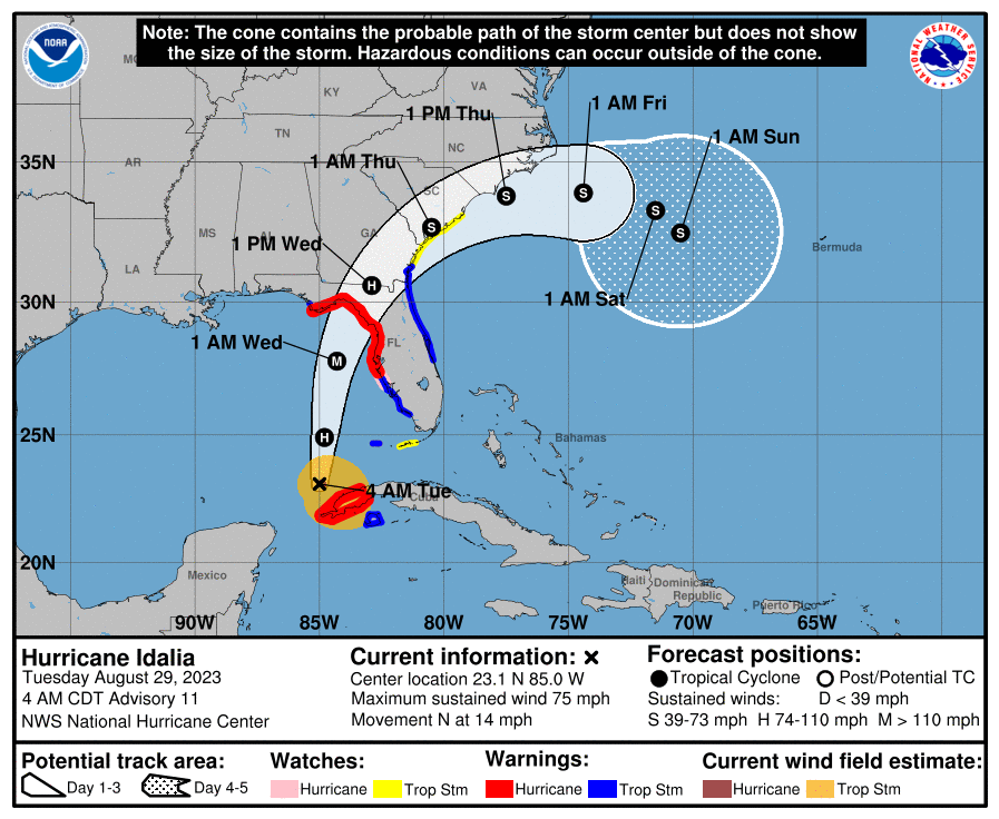
5AM forecast at 24 hours is
24H 30/0600Z 27.8N 84.3W 105 KT 120 MPH
Astronomical unusually high tide comes about ~10:30 AM on Wednesday for Tampa bay area.
This will be the highest tide Tampa bay has seen in a while so we will get a better idea if our flood surge models are accurate for the future.
All zone A has been evacuated.
And of course I have the PTSD inflicted by Charley and Ian so will be wobble watching and checking on the trough soundings.
3 likes

Re: ATL: IDALIA - Hurricane - Discussion
SFLcane wrote::double:
https://i.postimg.cc/N018mWHC/IMG-7526.jpg
They keep it as a storm..
https://i.postimg.cc/nrvMPJnN/IMG-7527.png
While much to early to speculate can you imagine it landfilling three separate times. First as a major into Florida, then circle around and landfall into Florida again and then landfall again somewhere over the Gulf after crossing over Florida and strengthening.
6 likes
-
jlauderdal
- S2K Supporter
- Posts: 7240
- Joined: Wed May 19, 2004 5:46 am
- Location: NE Fort Lauderdale
- Contact:
Re: ATL: IDALIA - Hurricane - Discussion
SFLcane wrote::double:
https://i.postimg.cc/N018mWHC/IMG-7526.jpg
They keep it as a storm..
https://i.postimg.cc/nrvMPJnN/IMG-7527.png
idalia with the loop, this systems likes to do loops and good ensemble support for the wave coming off africa, busy times
2 likes

Re: ATL: IDALIA - Hurricane - Discussion
sarcean wrote:SFLcane wrote::double:
https://i.postimg.cc/N018mWHC/IMG-7526.jpg
They keep it as a storm..
https://i.postimg.cc/nrvMPJnN/IMG-7527.png
While much to early to speculate can you imagine it landfilling three separate times. First as a major into Florida, then circle around and landfall into Florida again and then landfall again somewhere over the Gulf after crossing over Florida and strengthening.
Bonus points if the third landfall is in FL panhandle.
4 likes
TC naming lists: retirements and intensity
Most aggressive Advisory #1's in North Atlantic (cr. kevin for starting the list)
Most aggressive Advisory #1's in North Atlantic (cr. kevin for starting the list)

Re: ATL: IDALIA - Hurricane - Discussion
Today’s 5am advisory puts Idalia at 23.1N/85.0W.
Monday’s 5am advisory estimated she would be at 22.6N/85.1W as of today’s 5am advisory.
So, seems that it is slightly further N and E than they expected yesterday morning. Real question will be how long she keeps this N heading before the NNE turn.
Monday’s 5am advisory estimated she would be at 22.6N/85.1W as of today’s 5am advisory.
So, seems that it is slightly further N and E than they expected yesterday morning. Real question will be how long she keeps this N heading before the NNE turn.
1 likes
-
Iceresistance

- Category 5

- Posts: 9565
- Age: 22
- Joined: Sat Oct 10, 2020 9:45 am
- Location: Tecumseh, OK/Norman, OK
Re: ATL: IDALIA - Hurricane - Discussion
I just woke up, what did I miss?
0 likes
Bill 2015 & Beta 2020
Winter 2020-2021
All observations are in Tecumseh, OK unless otherwise noted.
Winter posts are focused mainly for Oklahoma & Texas.
Take any of my forecasts with a grain of salt, refer to the NWS, SPC, and NHC for official information
Never say Never with weather! Because ANYTHING is possible!
Winter 2020-2021
All observations are in Tecumseh, OK unless otherwise noted.
Winter posts are focused mainly for Oklahoma & Texas.
Take any of my forecasts with a grain of salt, refer to the NWS, SPC, and NHC for official information
Never say Never with weather! Because ANYTHING is possible!
-
jlauderdal
- S2K Supporter
- Posts: 7240
- Joined: Wed May 19, 2004 5:46 am
- Location: NE Fort Lauderdale
- Contact:
Re: ATL: IDALIA - Hurricane - Discussion
aspen wrote:Strap yourselves in ladies and gentlemen. The next 24-36 hours are gonna be a wild ride.
How about the next 10 days at least, idalia coming back and a very robust system looking like it comes all the way across. Lets also not forget how complex intensity forecasting is, Not long ago wxman 57 had it at 55knts at landfall which made perfect sense at the time based on modeling, NHC has been ramping up too. Track forecasting has improved much faster than intensity forecasting.
1 likes
-
Keldeo1997
- Category 2
- Posts: 688
- Joined: Fri Oct 11, 2019 11:35 pm

Who is online
Users browsing this forum: No registered users and 18 guests