ATL: LEE - Models

Moderator: S2k Moderators

Message
Author
User avatar
mitchell
Category 1
Category 1
Posts: 405
Joined: Wed Mar 19, 2003 8:22 am
Location: Delaware
Contact:

Re: ATL: LEE - Models

#461 Postby mitchell » Wed Sep 06, 2023 11:55 am

GCANE wrote:GFS is developing the storm to Lee's east more strongly.
The Fuji effect will give a SE tug on Lee making it look like Lee is slowing down.


The motion of those two systems on the 12 z GFS is interesting. The eastern system gets to the north of Lee, then as LEE chugs up the gulf stream towards SE Canada, the easterly system seems pushed back south several hundred miles
2 likes   

jlauderdal
S2K Supporter
S2K Supporter
Posts: 7177
Joined: Wed May 19, 2004 5:46 am
Location: NE Fort Lauderdale
Contact:

Re: ATL: LEE - Models

#462 Postby jlauderdal » Wed Sep 06, 2023 12:13 pm

Ianswfl wrote:
Iceresistance wrote:
Ianswfl wrote:
Why do you say a southeast threat?

I think I meant to say "Southeast area of the east coast" :oops:


Still, why do you think it would be a SE coast threat like FL, GA, or SC with the model trends?

This isnt a SE coast storm, time to move on from that theory,hope or whatever it is, not happening regardless of a little south or west trend the next few days...north carolina and north, maybe. Southwest Florida will not have any direct effects from Lee. Enjoy the lower dewpoints and good weather in SW Florida.
5 likes   

shortwave72
Tropical Wave
Tropical Wave
Posts: 1
Joined: Thu Aug 24, 2023 10:37 am

Re: ATL: LEE - Models

#463 Postby shortwave72 » Wed Sep 06, 2023 12:17 pm

Given the synoptic setup currently and the 10 day forecast of possible placement of the ridge in the Atlantic and the positive tilted trough at roughly the eastern conus it seems like everything from D.C. down to Miami has about a 1% chance, NE 15% chance and Atlantic Canada the highest at around a 40% possibility of seeing direct effects. This is based solely on the past few days of the global models and current mid level tropospheric height positions. IF the persistent toughing over the eastern US was west about 500 miles then I'd be concerned more other than fisherman and shipping.
0 likes   

User avatar
Woofde
Category 1
Category 1
Posts: 475
Joined: Tue Jul 06, 2021 11:33 am

Re: RE: Re: ATL: LEE - Models

#464 Postby Woofde » Wed Sep 06, 2023 12:21 pm

jlauderdal wrote:
Ianswfl wrote:
Iceresistance wrote:I think I meant to say "Southeast area of the east coast" :oops:


Still, why do you think it would be a SE coast threat like FL, GA, or SC with the model trends?

This isnt a SE coast storm, time to move on from that theory,hope or whatever it is, not happening regardless of a little south or west trend the next few days...north carolina and north, maybe. Southwest Florida will not have any direct effects from Lee. Enjoy the lower dewpoints and good weather in SW Florida.
I'm not gonna say it's likely a SE storm, because that's not a favored pattern. That said just look at the GFS 7 days out. Models become unskilled fast past this point. I don't think it's reasonable to rule out the Southeast just yet. There's good reason the NHC cone only goes out 5 days.Image
7 likes   

jhpigott
Category 2
Category 2
Posts: 570
Joined: Wed Jan 02, 2008 8:09 pm
Location: North Palm Beach, Florida

Re: ATL: LEE - Models

#465 Postby jhpigott » Wed Sep 06, 2023 12:33 pm

The 12z GEFS ensembles have a handful of rogue members that get uncomfortably close to the SE coast

https://www.tropicaltidbits.com/analysi ... 90612&fh=0
0 likes   

User avatar
CronkPSU
S2K Supporter
S2K Supporter
Posts: 2014
Joined: Sun Aug 07, 2005 10:44 pm
Location: Avalon Park, FL

Re: ATL: LEE - Models

#466 Postby CronkPSU » Wed Sep 06, 2023 12:35 pm

jlauderdal wrote:
Ianswfl wrote:
Iceresistance wrote:I think I meant to say "Southeast area of the east coast" :oops:


Still, why do you think it would be a SE coast threat like FL, GA, or SC with the model trends?

This isnt a SE coast storm, time to move on from that theory,hope or whatever it is, not happening regardless of a little south or west trend the next few days...north carolina and north, maybe. Southwest Florida will not have any direct effects from Lee. Enjoy the lower dewpoints and good weather in SW Florida.


seems like an overly bold statement more than 10 days out...Lee is unlikely to hit the SE coast but not definite in any sense of the word
2 likes   
Just like Jon Snow..."I know nothing" except what I know, and most of what I know is gathered by the fine people of the NHC

AutoPenalti
Category 5
Category 5
Posts: 4029
Age: 28
Joined: Mon Aug 17, 2015 4:16 pm
Location: Ft. Lauderdale, Florida

Re: ATL: LEE - Models

#467 Postby AutoPenalti » Wed Sep 06, 2023 12:41 pm

Some people may have forgotten:

a) how far this is from mainland US
and
b) how slow this is going

Let's focus on the Caribbean first.

GEFS has a couple of members hitting SFL already.
Last edited by AutoPenalti on Wed Sep 06, 2023 12:46 pm, edited 1 time in total.
6 likes   
The posts in this forum are NOT official forecasts and should not be used as such. They are just the opinion of the poster and may or may not be backed by sound meteorological data. They are NOT endorsed by any professional institution or STORM2K. For official information, please refer to products from the NHC and NWS.


Model Runs Cheat Sheet:
GFS (5:30 AM/PM, 11:30 AM/PM)
HWRF, GFDL, UKMET, NAVGEM (6:30-8:00 AM/PM, 12:30-2:00 AM/PM)
ECMWF (1:45 AM/PM)

TCVN
is a weighted averaged

User avatar
cheezyWXguy
Category 5
Category 5
Posts: 6092
Joined: Mon Feb 13, 2006 12:29 am
Location: Dallas, TX

Re: RE: Re: ATL: LEE - Models

#468 Postby cheezyWXguy » Wed Sep 06, 2023 12:43 pm

Woofde wrote:
jlauderdal wrote:
Ianswfl wrote:
Still, why do you think it would be a SE coast threat like FL, GA, or SC with the model trends?

This isnt a SE coast storm, time to move on from that theory,hope or whatever it is, not happening regardless of a little south or west trend the next few days...north carolina and north, maybe. Southwest Florida will not have any direct effects from Lee. Enjoy the lower dewpoints and good weather in SW Florida.
I'm not gonna say it's likely a SE storm, because that's not a favored pattern. That said just look at the GFS 7 days out. Models become unskilled fast past this point. I don't think it's reasonable to rule out the Southeast just yet. There's good reason the NHC cone only goes out 5 days.https://uploads.tapatalk-cdn.com/20230906/5edf5554d4d5e84979948aa0f0a27e34.jpg

This is a good point. It’s definitely less likely that anything south of the Carolinas would take a direct impact here, but I still wouldn’t rule it out. I genuinely wonder where the fish bandwagoners are getting their confidence from, because the gfs runs don’t instill a lot of confidence yet in me. Even the runs that miss are an extremely close call, and more importantly, the 500mb setup in 7+ days is still showing a good deal of run to run variation.

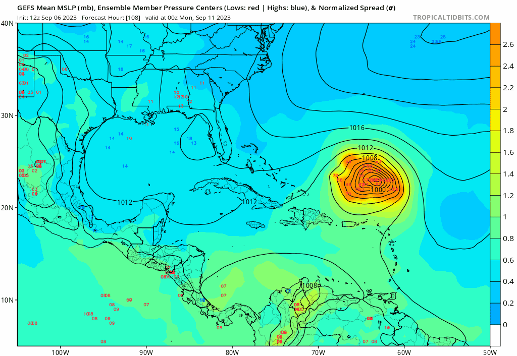
I’m not going to post a map, but y’all should go take a look at the 12z gefs. The first camp darts northward, a second camp hangs out a little longer and passes near the east coast, and a few trailing members present a greater threat. If anything, the spread may have actually increased over the last few runs beyond day 7, highlighting continued uncertainty in the timing and evolution of the trough.

The storm and the setup are going to eventually do what they do, regardless of what one hopes for, and the ultimate outcome can’t be accurately forecast yet. This isn’t politics where something becomes true if it gets repeated enough times.
6 likes   

AxaltaRacing24
Category 5
Category 5
Posts: 1753
Age: 25
Joined: Wed Jul 27, 2016 11:14 am
Location: Jupiter, FL

Re: ATL: LEE - Models

#469 Postby AxaltaRacing24 » Wed Sep 06, 2023 12:47 pm

AutoPenalti wrote:Some people may have forgotten how:
a) how far this is from mainland US
and
b) how slow this is going

Let's focus on the Caribbean first.

GEFS has a couple of members hitting SFL already.

You cannot currently rule out entire areas for landfall probability when they have multiple ensemble members hitting them.

example
2 likes   

User avatar
aspen
Category 5
Category 5
Posts: 8812
Joined: Sat Oct 12, 2019 7:10 pm
Location: Connecticut, USA

Re: ATL: LEE - Models

#470 Postby aspen » Wed Sep 06, 2023 12:52 pm

12z HAFS-B is absolutely insane. 160 kt and 898 mbar on Sunday night.
5 likes   
Irene '11 Sandy '12 Hermine '16 5/15/2018 Derecho Fay '20 Isaias '20 Elsa '21 Henri '21 Ida '21

I am only a meteorology enthusiast who knows a decent amount about tropical cyclones. Look to the professional mets, the NHC, or your local weather office for the best information.

User avatar
ElectricStorm
Category 5
Category 5
Posts: 5017
Age: 24
Joined: Tue Aug 13, 2019 11:23 pm
Location: Skiatook, OK / Norman, OK

Re: ATL: LEE - Models

#471 Postby ElectricStorm » Wed Sep 06, 2023 12:53 pm

HAFS-B 12z peaks at 162kts/897mb...
5 likes   
I am in no way a professional. Take what I say with a grain of salt as I could be totally wrong. Please refer to the NHC, NWS, or SPC for official information.

Boomer Sooner!

Ianswfl
Category 1
Category 1
Posts: 482
Joined: Thu Mar 23, 2023 11:11 pm

Re: ATL: LEE - Models

#472 Postby Ianswfl » Wed Sep 06, 2023 12:54 pm

AxaltaRacing24 wrote:
AutoPenalti wrote:Some people may have forgotten how:
a) how far this is from mainland US
and
b) how slow this is going

Let's focus on the Caribbean first.

GEFS has a couple of members hitting SFL already.

You cannot currently rule out entire areas for landfall probability when they have multiple ensemble members hitting them.

example
https://imgur.com/50NOOLJ


Yea, just saw that. A nasty, cat4 member hitting southern Fl and riding up SWFL like Irma did and another member is a cat1. Euro enesembles last night also had some tracks bending back.

It seems the slower this moves the more west it might go. The wave behind it might also become powerful and tug on it, slowing it down some are talking about.
3 likes   

LarryWx
Category 5
Category 5
Posts: 6246
Joined: Sun Sep 07, 2003 2:04 pm
Location: GA

Re: ATL: LEE - Models

#473 Postby LarryWx » Wed Sep 06, 2023 12:54 pm

RevanTheJedi96 wrote:
LarryWx wrote:
Meteorcane wrote:
Still too much uncertainty in the long term to feel too safe about Bermuda, Atlantic Canada, and the NE US. I still wouldn't necessarily say there is no threat for the Turks and Caicos and eastern Bahamas either... only takes a somewhat stronger ridge.


If anything, the risk to Bermuda is increasing. But the risk to the NE US, after a bit of a concern largely based on the far left UKMET, has dropped somewhat from how it looked earlier. Hopefully future UKMETs will not go back as far left as they were. However, I'm still maintaining a small risk of landfall to the NE US because we're still 9 or so days out...too long to give an all clear.


Well if Larry Wx says the Northeast is safe, it must be!


I obviously said nothing of the sort. Look at what you quoted. I said that the risk to the NE has "dropped somewhat" based on the 0Z UKMET's track's 200 mile E shift vs yesterday's 12Z run but that I'm still keeping a "small risk of landfall" due to how far out in time it is. So, nowhere did I say anything about them being "safe".
7 likes   
Personal Forecast Disclaimer:
The posts in this forum are NOT official forecasts and should not be used as such. They are just the opinion of the poster and may or may not be backed by sound meteorological data. They are NOT endorsed by any professional institution or storm2k.org. For official information, please refer to the NHC and NWS products.

User avatar
ThunderForce
Tropical Storm
Tropical Storm
Posts: 208
Age: 25
Joined: Tue Sep 27, 2022 6:20 pm
Location: Calhoun County, Florida

Re: ATL: LEE - Models

#474 Postby ThunderForce » Wed Sep 06, 2023 12:57 pm

The 12z GEFS members that go into South FL seem to perform a southwestward motion for about a day's time (12z to 12z) before returning to a west/west-northwestward movement that leads to landfalling in that location.
0 likes   
Please refer to the NWS, NHC, SPC or a professional meteorologist for information and decision making during storms.

User avatar
SFLcane
S2K Supporter
S2K Supporter
Posts: 10162
Age: 47
Joined: Sat Jun 05, 2010 1:44 pm
Location: Lake Worth Florida

Re: ATL: LEE - Models

#475 Postby SFLcane » Wed Sep 06, 2023 1:05 pm

AutoPenalti wrote:Some people may have forgotten:

a) how far this is from mainland US
and
b) how slow this is going

Let's focus on the Caribbean first.

GEFS has a couple of members hitting SFL already.


Crazy members... :roll:

Image
0 likes   

User avatar
REDHurricane
Category 1
Category 1
Posts: 395
Age: 27
Joined: Sun Jul 03, 2022 2:36 pm
Location: Northeast Pacific Ocean

Re: ATL: LEE - Models

#476 Postby REDHurricane » Wed Sep 06, 2023 1:06 pm

Whew

Image

Image
6 likes   

jlauderdal
S2K Supporter
S2K Supporter
Posts: 7177
Joined: Wed May 19, 2004 5:46 am
Location: NE Fort Lauderdale
Contact:

Re: RE: Re: ATL: LEE - Models

#477 Postby jlauderdal » Wed Sep 06, 2023 1:06 pm

Woofde wrote:
jlauderdal wrote:
Ianswfl wrote:
Still, why do you think it would be a SE coast threat like FL, GA, or SC with the model trends?

This isnt a SE coast storm, time to move on from that theory,hope or whatever it is, not happening regardless of a little south or west trend the next few days...north carolina and north, maybe. Southwest Florida will not have any direct effects from Lee. Enjoy the lower dewpoints and good weather in SW Florida.
I'm not gonna say it's likely a SE storm, because that's not a favored pattern. That said just look at the GFS 7 days out. Models become unskilled fast past this point. I don't think it's reasonable to rule out the Southeast just yet. There's good reason the NHC cone only goes out 5 days.https://uploads.tapatalk-cdn.com/20230906/5edf5554d4d5e84979948aa0f0a27e34.jpg

Fortunately, the gfs isnt all we have to look at, if this storm makes landfall south of cape hatteress, 10lbs of crow for me..if this was a Florida threat or anything close to it, this board would be on fire, too many people on this forum with too much experience to miss that as a reasonable scenario including yours truly...recon will start feeding the models and hopefully that will put the SE coast idea where it belongs...in the meantime, make sure you are ready wherever you are located.
1 likes   

LarryWx
Category 5
Category 5
Posts: 6246
Joined: Sun Sep 07, 2003 2:04 pm
Location: GA

Re: ATL: LEE - Models

#478 Postby LarryWx » Wed Sep 06, 2023 1:10 pm

The 12Z UKMET is similar to the 0Z and thus the ~200 mile E shift of today's 0Z vs yesterday's more ominous 12Z was maintained. Regardless, I maintain there's still a chance for the NE US to be hit albeit a small chance. When I say small, I mean something like 20%, which is nothing to take lightly as they're nowhere near safe at this point. Although the highest % of Euro ens members hitting the NE US so far is 10%, I'm still at double that due to how far out in time it still is.

At 168, the 12Z UKMET has Lee ~250 miles NE of the SE Bahamas moving NNW:

TROPICAL STORM LEE ANALYSED POSITION : 13.7N 44.8W

ATCF IDENTIFIER : AL132023

LEAD CENTRAL MAXIMUM WIND
VERIFYING TIME TIME POSITION PRESSURE (MB) SPEED (KNOTS)
-------------- ---- -------- ------------- -------------
1200UTC 06.09.2023 0 13.7N 44.8W 1003 43
0000UTC 07.09.2023 12 15.3N 46.6W 1002 43
1200UTC 07.09.2023 24 16.3N 49.3W 1000 41
0000UTC 08.09.2023 36 17.0N 51.8W 1000 40
1200UTC 08.09.2023 48 17.7N 54.6W 997 55
0000UTC 09.09.2023 60 18.3N 57.0W 997 52
1200UTC 09.09.2023 72 19.1N 59.3W 997 53
0000UTC 10.09.2023 84 19.7N 61.1W 997 55
1200UTC 10.09.2023 96 20.0N 63.1W 994 57
0000UTC 11.09.2023 108 20.6N 64.4W 994 53
1200UTC 11.09.2023 120 20.9N 65.6W 994 53
0000UTC 12.09.2023 132 21.7N 66.8W 991 56
1200UTC 12.09.2023 144 22.6N 67.3W 985 50
0000UTC 13.09.2023 156 23.4N 68.4W 978 52
1200UTC 13.09.2023 168 24.2N 68.9W 973 61
1 likes   
Personal Forecast Disclaimer:
The posts in this forum are NOT official forecasts and should not be used as such. They are just the opinion of the poster and may or may not be backed by sound meteorological data. They are NOT endorsed by any professional institution or storm2k.org. For official information, please refer to the NHC and NWS products.

User avatar
toad strangler
S2K Supporter
S2K Supporter
Posts: 4543
Joined: Sun Jul 28, 2013 3:09 pm
Location: Earth
Contact:

Re: RE: Re: ATL: LEE - Models

#479 Postby toad strangler » Wed Sep 06, 2023 1:13 pm

jlauderdal wrote:
Woofde wrote:
jlauderdal wrote:This isnt a SE coast storm, time to move on from that theory,hope or whatever it is, not happening regardless of a little south or west trend the next few days...north carolina and north, maybe. Southwest Florida will not have any direct effects from Lee. Enjoy the lower dewpoints and good weather in SW Florida.
I'm not gonna say it's likely a SE storm, because that's not a favored pattern. That said just look at the GFS 7 days out. Models become unskilled fast past this point. I don't think it's reasonable to rule out the Southeast just yet. There's good reason the NHC cone only goes out 5 days.https://uploads.tapatalk-cdn.com/20230906/5edf5554d4d5e84979948aa0f0a27e34.jpg

Fortunately, the gfs isnt all we have to look at, if this storm makes landfall south of cape hatteress, 10lbs of crow for me..if this was a Florida threat or anything close to it, this board would be on fire, too many people on this forum with too much experience to miss that as a reasonable scenario including yours truly...recon will start feeding the models and hopefully that will put the SE coast idea where it belongs...in the meantime, make sure you are ready wherever you are located.


The only thing set in stone is a re-curve. It's the when and where that aint! So the next step for me is climatology. That implies a re-curve east of the Mid Atlantic and SE Us coasts. It would take some gnarly anomalous ridging to putt Lee all the way to FL. Hopefully the Lesser and Greater A's are off the hook here because ya, they are 1st and 2nd up.
1 likes   

mantis83
Tropical Storm
Tropical Storm
Posts: 198
Joined: Fri Dec 05, 2003 4:47 pm

Re: RE: Re: ATL: LEE - Models

#480 Postby mantis83 » Wed Sep 06, 2023 1:17 pm

toad strangler wrote:
jlauderdal wrote:
Woofde wrote:I'm not gonna say it's likely a SE storm, because that's not a favored pattern. That said just look at the GFS 7 days out. Models become unskilled fast past this point. I don't think it's reasonable to rule out the Southeast just yet. There's good reason the NHC cone only goes out 5 days.https://uploads.tapatalk-cdn.com/20230906/5edf5554d4d5e84979948aa0f0a27e34.jpg

Fortunately, the gfs isnt all we have to look at, if this storm makes landfall south of cape hatteress, 10lbs of crow for me..if this was a Florida threat or anything close to it, this board would be on fire, too many people on this forum with too much experience to miss that as a reasonable scenario including yours truly...recon will start feeding the models and hopefully that will put the SE coast idea where it belongs...in the meantime, make sure you are ready wherever you are located.


The only thing set in stone is a re-curve. It's the when and where that aint! So the next step for me is climatology. That implies a re-curve east of the Mid Atlantic and SE Us coasts. It would take some gnarly anomalous ridging to putt Lee all the way to FL. Hopefully the Lesser and Greater A's are off the hook here because ya, they are 1st and 2nd up.

agreed!
0 likes   


Return to “2023”

Who is online

Users browsing this forum: No registered users and 30 guests