ATL: LEE - Post-Tropical - Discussion
Moderator: S2k Moderators
-
FLpanhandle91

- Category 5

- Posts: 1039
- Age: 34
- Joined: Mon Sep 13, 2010 3:50 pm
- Location: Fort Walton Beach, FL
Re: ATL: LEE - Hurricane - Discussion: Forecast to be Cat 5
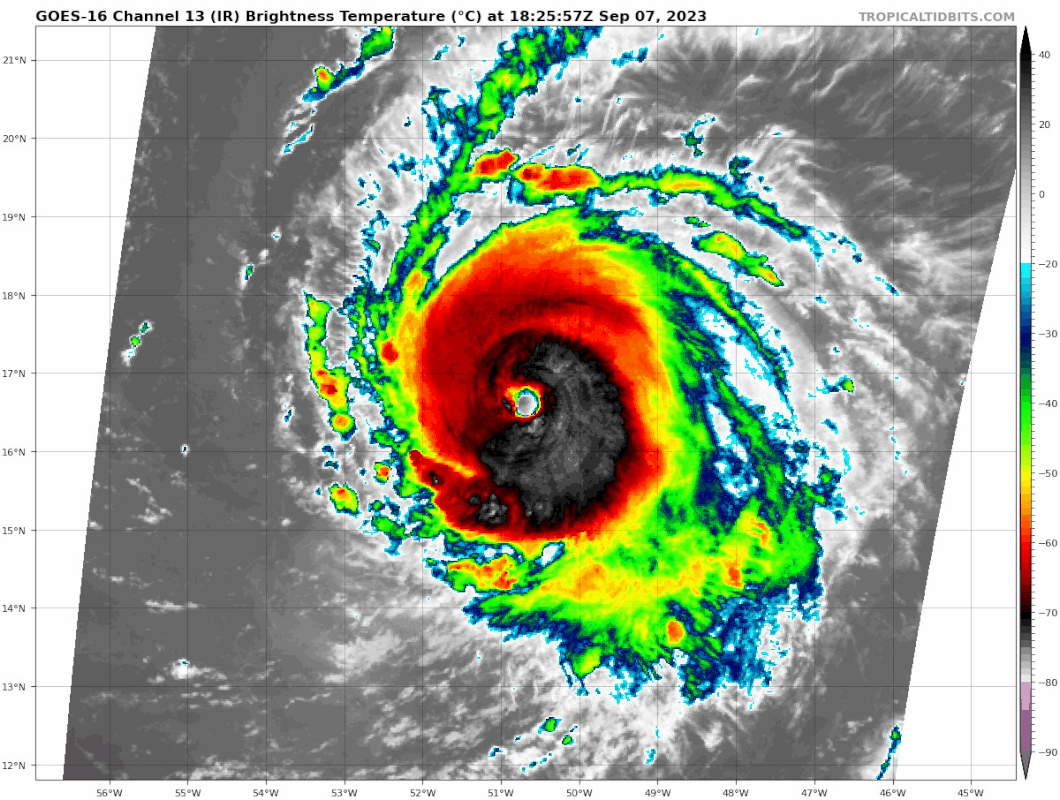
Very warm eye. Remember, in this basin it is common that eye temperature is more indicative of strength than CDO temperature.
7 likes
-
Iceresistance

- Category 5
- Posts: 9579
- Age: 22
- Joined: Sat Oct 10, 2020 9:45 am
- Location: Tecumseh, OK/Norman, OK
Re: ATL: LEE - Hurricane - Discussion: Forecast to be Cat 5
That was MUCH earlier than I expected
AF305 Mission #1 into LEE
Type: Unknown | Status: In Progress
Type: Unknown | Status: In Progress
1 likes
Bill 2015 & Beta 2020
Winter 2020-2021
All observations are in Tecumseh, OK unless otherwise noted.
Winter posts are focused mainly for Oklahoma & Texas.
Take any of my forecasts with a grain of salt, refer to the NWS, SPC, and NHC for official information
Never say Never with weather! Because ANYTHING is possible!
Winter 2020-2021
All observations are in Tecumseh, OK unless otherwise noted.
Winter posts are focused mainly for Oklahoma & Texas.
Take any of my forecasts with a grain of salt, refer to the NWS, SPC, and NHC for official information
Never say Never with weather! Because ANYTHING is possible!
-
KirbyDude25

- Tropical Storm

- Posts: 161
- Age: 20
- Joined: Mon Sep 20, 2021 8:03 am
- Location: Westfield, New Jersey
Re: ATL: LEE - Hurricane - Discussion: Forecast to be Cat 5
Iceresistance wrote:That was MUCH earlier than I expectedAF305 Mission #1 into LEE
Type: Unknown | Status: In Progress
I believe that's the upper-level mission. The lower-level one takes off around 5 PM Eastern and will arrive at Lee's center about 2.5 hours after
2 likes
New Jersey, Rutgers '27
Irene 2011 | Sandy 2012 | Fay 2020 | Isaias 2020 | Ida 2021
Irene 2011 | Sandy 2012 | Fay 2020 | Isaias 2020 | Ida 2021
-
Iceresistance
- Category 5
- Posts: 9579
- Age: 22
- Joined: Sat Oct 10, 2020 9:45 am
- Location: Tecumseh, OK/Norman, OK
Re: ATL: LEE - Hurricane - Discussion: Forecast to be Cat 5
KirbyDude25 wrote:Iceresistance wrote:That was MUCH earlier than I expectedAF305 Mission #1 into LEE
Type: Unknown | Status: In Progress
I believe that's the upper-level mission. The lower-level one takes off around 5 PM Eastern and will arrive at Lee's center about 2.5 hours after
Well, that is going to be plugged into the models with the dropsondes.
0 likes
Bill 2015 & Beta 2020
Winter 2020-2021
All observations are in Tecumseh, OK unless otherwise noted.
Winter posts are focused mainly for Oklahoma & Texas.
Take any of my forecasts with a grain of salt, refer to the NWS, SPC, and NHC for official information
Never say Never with weather! Because ANYTHING is possible!
Winter 2020-2021
All observations are in Tecumseh, OK unless otherwise noted.
Winter posts are focused mainly for Oklahoma & Texas.
Take any of my forecasts with a grain of salt, refer to the NWS, SPC, and NHC for official information
Never say Never with weather! Because ANYTHING is possible!
-
Hurricaneman

- Category 5
- Posts: 7404
- Age: 45
- Joined: Tue Aug 31, 2004 3:24 pm
- Location: central florida
Re: ATL: LEE - Hurricane - Discussion: Forecast to be Cat 5
Iceresistance wrote:KirbyDude25 wrote:Iceresistance wrote:That was MUCH earlier than I expectedAF305 Mission #1 into LEE
Type: Unknown | Status: In Progress
I believe that's the upper-level mission. The lower-level one takes off around 5 PM Eastern and will arrive at Lee's center about 2.5 hours after
Well, that is going to be plugged into the models with the dropsondes.
Probably the 0z runs and a few on the 18z runs
0 likes
-
KirbyDude25
- Tropical Storm
- Posts: 161
- Age: 20
- Joined: Mon Sep 20, 2021 8:03 am
- Location: Westfield, New Jersey
Re: ATL: LEE - Hurricane - Discussion: Forecast to be Cat 5
Iceresistance wrote:KirbyDude25 wrote:Iceresistance wrote:That was MUCH earlier than I expectedAF305 Mission #1 into LEE
Type: Unknown | Status: In Progress
I believe that's the upper-level mission. The lower-level one takes off around 5 PM Eastern and will arrive at Lee's center about 2.5 hours after
Well, that is going to be plugged into the models with the dropsondes.
Guess I misunderstood a bit, sorry. The TCPOD did say that an upper-level mission would leave around this time; I think I just misinterpreted your reaction somewhat. Looking forward to the results of both missions.
0 likes
New Jersey, Rutgers '27
Irene 2011 | Sandy 2012 | Fay 2020 | Isaias 2020 | Ida 2021
Irene 2011 | Sandy 2012 | Fay 2020 | Isaias 2020 | Ida 2021
-
cycloneye

- Admin

- Posts: 149294
- Age: 69
- Joined: Thu Oct 10, 2002 10:54 am
- Location: San Juan, Puerto Rico
Re: ATL: LEE - Hurricane - Discussion: Forecast to be Cat 5
KirbyDude25 wrote:Iceresistance wrote:That was MUCH earlier than I expectedAF305 Mission #1 into LEE
Type: Unknown | Status: In Progress
I believe that's the upper-level mission. The lower-level one takes off around 5 PM Eastern and will arrive at Lee's center about 2.5 hours after
What I have is a survellance flight now and then at 5 PM goes the one to do the fixes.
FLIGHT ONE - TEAL 74 FLIGHT TWO - TEAL 75
A. 08/0000Z A. 07/2330Z,08/0530Z
B. AFXXX 0113A LEE B. AFXXX 0213A LEE
C. 07/1730Z C. 07/2100Z
D. NA D. 16.6N 52.2W
E. NA E. 07/2300Z TO 08/0530Z
F. 24,000 FT TO 32,000 FT F. SFC TO 10,000 FT
G. SYNOPTIC SURVEILLANCE
A. 08/0000Z A. 07/2330Z,08/0530Z
B. AFXXX 0113A LEE B. AFXXX 0213A LEE
C. 07/1730Z C. 07/2100Z
D. NA D. 16.6N 52.2W
E. NA E. 07/2300Z TO 08/0530Z
F. 24,000 FT TO 32,000 FT F. SFC TO 10,000 FT
G. SYNOPTIC SURVEILLANCE
2 likes
Visit the Caribbean-Central America Weather Thread where you can find at first post web cams,radars
and observations from Caribbean basin members Click Here
and observations from Caribbean basin members Click Here
-
MarioProtVI
- Category 5
- Posts: 1034
- Age: 24
- Joined: Sun Sep 29, 2019 7:33 pm
- Location: New Jersey
Re: ATL: LEE - Hurricane - Discussion: Forecast to be Cat 5
AL, 13, 2023090718, , BEST, 0, 166N, 507W, 105, 961, HU, 64, NEQ, 25, 20, 20, 20, 1011, 250, 15, 0, 0, L, 0, , 0, 0, LEE, D, 0, , 0, 0, 0, 0, genesis-num, 027,
Cat 3
Cat 3
6 likes

Re: ATL: LEE - Hurricane - Discussion Update: 18z Best Track up to Cat 3, 105 kt
Even on 1-min floaters, the rate of intensification is incredible.
13 likes
TC naming lists: retirements and intensity
Most aggressive Advisory #1's in North Atlantic (cr. kevin for starting the list)
Most aggressive Advisory #1's in North Atlantic (cr. kevin for starting the list)
-
WalterWhite

- Category 1

- Posts: 342
- Joined: Fri Mar 17, 2023 5:53 pm
Re: ATL: LEE - Hurricane - Discussion Update: 18z Best Track up to Cat 3, 105 kt
We now have Major Hurricane Lee. It is official.
AL, 13, 2023090718, , BEST, 0, 166N, 507W, 105, 961, HU, 64, NEQ, 25, 20, 20, 20, 1011, 250, 15, 130, 0, L, 0, , 0, 0, LEE, D, 0, , 0, 0, 0, 0, genesis-num, 027,
3 likes

Re: ATL: LEE - Hurricane - Discussion Update: 18z Best Track up to Cat 3, 105 kt
WalterWhite wrote:We now have Major Hurricane Lee. It is official.AL, 13, 2023090718, , BEST, 0, 166N, 507W, 105, 961, HU, 64, NEQ, 25, 20, 20, 20, 1011, 250, 15, 130, 0, L, 0, , 0, 0, LEE, D, 0, , 0, 0, 0, 0, genesis-num, 027,
If they go 105 kt that would be a very impressive 35 kt intensification in 12 hours. Note that the RI requirement is only 30 kt in 24 hours so this is far beyond that.
6 likes

Re: ATL: LEE - Hurricane - Discussion Update: 18z Best Track up to Cat 3, 105 kt
Dvorak from SAB at constrained 5.5
A. 13L (LEE)
B. 07/1800Z
C. 16.6N
D. 50.7W
E. ONE/GOES-E
F. T5.5/5.5
G. IR/EIR/VIS
H. REMARKS...A WMG EYE SURROUNDED AND EMBEDDED IN B YIELDS A DT OF
6.5. THE MET IS 5.0 DUE TO 24 HOUR RAPID DEVELOPMETN TREND. THE PT IS
5.5. RAPID DEVELOPMENT 6-HOUR AVERAGING RESULTS IN A DT OF 5.8 WHICH
DOES NOT JUSTIFY BREAKING THE CONSTRAINTS THAT THE T-NO CANNOT CHANGE
BY MORE THAT 1.0 OVER 6 HOURS.
I. ADDL POSITIONS
NIL
...BROWN
0 likes
Re: ATL: LEE - Hurricane - Discussion Update: 18z Best Track up to Cat 3, 105 kt
Centre region temp is 18.4C and is already approaching the highest value Jova ever had (20.3C). Raw T# also already up to 6.6 now. We're really seeing the most impressive RI of both the EPAC and the NATL in years on the same day  . What are the chances.
. What are the chances.
7 likes
-
bob rulz
- Category 5
- Posts: 1711
- Age: 35
- Joined: Sat Jan 28, 2006 7:30 pm
- Location: Salt Lake City, Utah
Re: ATL: LEE - Hurricane - Discussion Update: 18z Best Track up to Cat 3, 105 kt
I think even 105kts is an underestimate. We'll know for sure in about 4 hours?
5 likes
-
rickcorvin
- Tropical Low

- Posts: 10
- Joined: Wed Jun 03, 2020 7:12 am
Re: ATL: LEE - Hurricane - Discussion Update: 18z Best Track up to Cat 3, 105 kt
Lee met the RI requirement yesterday, apparently met it today, and is forecast to meet it again over the next 24 hours. Maybe someone can run a query to see when a storm rapidly intensified in three consecutive 24 hour periods.kevin wrote:WalterWhite wrote:We now have Major Hurricane Lee. It is official.AL, 13, 2023090718, , BEST, 0, 166N, 507W, 105, 961, HU, 64, NEQ, 25, 20, 20, 20, 1011, 250, 15, 130, 0, L, 0, , 0, 0, LEE, D, 0, , 0, 0, 0, 0, genesis-num, 027,
If they go 105 kt that would be a very impressive 35 kt intensification in 12 hours. Note that the RI requirement is only 30 kt in 24 hours so this is far beyond that.
7 likes
-
cheezyWXguy

- Category 5
- Posts: 6282
- Joined: Mon Feb 13, 2006 12:29 am
- Location: Dallas, TX
Re: ATL: LEE - Hurricane - Discussion Update: 18z Best Track up to Cat 3, 105 kt
Cdo starting to uniformly cool now. W band all the way around the center with wmg in the eye on Dvorak. Jova’s transformation yesterday was amazing, but Lee’s is keeping right up there with it.
3 likes
-
Charleswachal
- S2K Supporter

- Posts: 118
- Age: 35
- Joined: Tue Sep 27, 2022 11:24 pm
Re: ATL: LEE - Hurricane - Discussion Update: 18z Best Track up to Cat 3, 105 kt
This is absolutely incredible. Looks like a Cat 4 already. Does take time for the winds to catch up but it is definitely rapidly intensifying
5 likes
Tropical Systems Experienced... Hurricane Harvey 2017 (Houston); Tropical Depression Imelda 2019 (Houston); Hurricane Nicolas 2021 (Houston), Hurricane Beryl 2024 (Eye Intercept)
-
Meteorcane

- Category 2

- Posts: 559
- Joined: Thu Jul 21, 2011 6:49 am
- Location: North Platte Nebraska
Re: ATL: LEE - Hurricane - Discussion Update: 18z Best Track up to Cat 3, 105 kt
Well not much to add here, but to say... Wow what a marked change in structure in only the last 12-15 hours! Honestly I expected only gradual organization today, with the real RI occurring tonight into tomorrow. This shows the internal structure was likely further along than many of us thought yesterday/last night despite the ragged IR structure. This view is at least partially supported by the fact that the microwave passes yesterday showed a pretty good and established core structure (better than what you would expect looking at IR and vis). Will be interesting to see the intensity trajectory over the next 5 days... environment obviously not a problem with low shear, high OHC, and a most low-mid lvls, so any intensity ups and downs will likely be driven primarily by EWRCs.
Let's all also be thankful this didn't end up being a NE Carib direct threat (obviously swells, surf, rips, etc notwithstanding).
Let's all also be thankful this didn't end up being a NE Carib direct threat (obviously swells, surf, rips, etc notwithstanding).
4 likes
-
cycloneye
- Admin
- Posts: 149294
- Age: 69
- Joined: Thu Oct 10, 2002 10:54 am
- Location: San Juan, Puerto Rico
Re: ATL: LEE - Hurricane - Discussion Update: 18z Best Track up to Cat 3, 105 kt
1 likes
Visit the Caribbean-Central America Weather Thread where you can find at first post web cams,radars
and observations from Caribbean basin members Click Here
and observations from Caribbean basin members Click Here
Re: ATL: LEE - Hurricane - Discussion Update: 18z Best Track up to Cat 3, 105 kt
Charleswachal wrote:This is absolutely incredible. Looks like a Cat 4 already. Does take time for the winds to catch up but it is definitely rapidly intensifying
Perhaps upgrade the name to Hurricane Lee Majors at the next update.
12 likes
Who is online
Users browsing this forum: No registered users and 13 guests