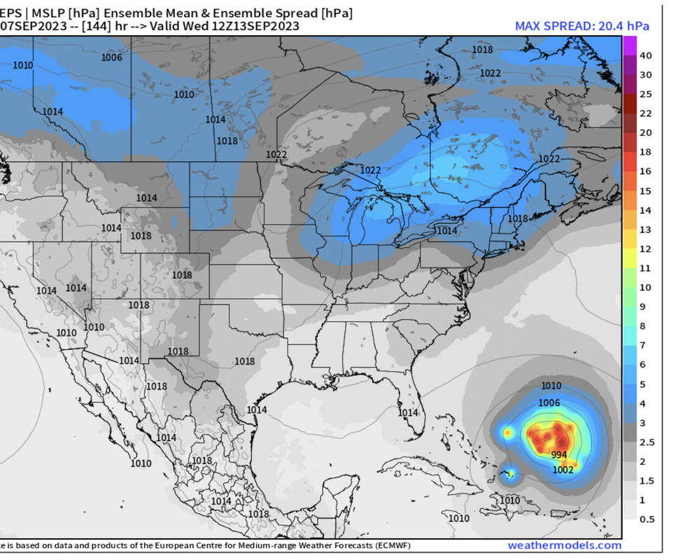
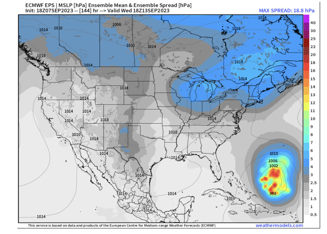
ATL: LEE - Models

Moderator: S2k Moderators

Message
Author
User avatar
chaser1
S2K Supporter
S2K Supporter
Posts: 5407
Age: 64
Joined: Sat Oct 15, 2005 5:59 pm
Location: Longwood, Fl

Re: ATL: LEE - Models

#661 Postby chaser1 » Thu Sep 07, 2023 9:07 pm

Ianswfl wrote:
chaser1 wrote:My mind keeps going back to both the HAFS A & B hurricane models from yesterday as well as today. Not to say that the EURO and GFS did not pick up on such a forecasted pattern at 120 hr's, but both hurricane model's resolution depicting Lee practically catching up to what appeared to be a newly developed H5 centered around the Florida Straits. A couple of days ago I believed that nearly every model was depicting a deep southwesterly flow as Lee approached 65W-70W as a result of the strong shortwave into the N GOM by next Tue. On both regional models however, it appeared as if the trough had turned full negative with basically slack winds over the E. Gulf instead and northerly steering just to the east of a building H5. Assuming "IF" Lee were slightly further south & west by next Monday, then it would appear that the only dominent steering would practically be northerly under this newly bridged or established H5 anticyclone. Seemingly like the prior H5 that was building west along with the WNW forward motion of Lee, is nearly "handing -off" Lee to a new or weaker level ridge to the southwest. To me, that set-up might imply a SW motion into Cuba. Timing of course would dictate whether this might reflect a sharpening trough allowing Lee to split some weakness along an existant NE/SW angled ridge and turn NNW as forecast.... OR possibly reflect the negatively tilted trough energy pulling out with mid level heights quickly filling in its wake? If none of the above ever transpires though and simply leaving Lee to drift for days well east of the Bahamas, a deeper trough looks to eventually enter the picture by later next week to sweep Lee northward (if still in the neighborhood). Anyhow, the odd tone of NHC's 5:00pm discussion left me pondering the thought.


Actually, a few GFS ensembles members and Euro ensembles members had the SW motion into Cuba, or just north of it a couple days ago. Euro ensembles shifted way north, but the 18z euro ensembles are trending a lot further south than 12z and too showing bending like Hafs B.


Perhaps a little ensemble windshield wiper affect? Time (and model support) will tell
1 likes   
Andy D

(For official information, please refer to the NHC and NWS products.)

User avatar
chaser1
S2K Supporter
S2K Supporter
Posts: 5407
Age: 64
Joined: Sat Oct 15, 2005 5:59 pm
Location: Longwood, Fl

Re: ATL: LEE - Models

#662 Postby chaser1 » Thu Sep 07, 2023 9:11 pm

SconnieCane wrote:
Ianswfl wrote:Actually, a few GFS ensembles members and Euro ensembles members had the SW motion into Cuba, or just north of it a couple days ago. Euro ensembles shifted way north, but the 18z euro ensembles are trending a lot further south than 12z and too showing bending like Hafs B.


Windshield wiper mode in full effect. Some things never change.


LOL, u beat me too it!
1 likes   
Andy D

(For official information, please refer to the NHC and NWS products.)

Ianswfl
Category 1
Category 1
Posts: 482
Joined: Thu Mar 23, 2023 11:11 pm

Re: ATL: LEE - Models

#663 Postby Ianswfl » Thu Sep 07, 2023 9:11 pm

chaser1 wrote:
Ianswfl wrote:
chaser1 wrote:My mind keeps going back to both the HAFS A & B hurricane models from yesterday as well as today. Not to say that the EURO and GFS did not pick up on such a forecasted pattern at 120 hr's, but both hurricane model's resolution depicting Lee practically catching up to what appeared to be a newly developed H5 centered around the Florida Straits. A couple of days ago I believed that nearly every model was depicting a deep southwesterly flow as Lee approached 65W-70W as a result of the strong shortwave into the N GOM by next Tue. On both regional models however, it appeared as if the trough had turned full negative with basically slack winds over the E. Gulf instead and northerly steering just to the east of a building H5. Assuming "IF" Lee were slightly further south & west by next Monday, then it would appear that the only dominent steering would practically be northerly under this newly bridged or established H5 anticyclone. Seemingly like the prior H5 that was building west along with the WNW forward motion of Lee, is nearly "handing -off" Lee to a new or weaker level ridge to the southwest. To me, that set-up might imply a SW motion into Cuba. Timing of course would dictate whether this might reflect a sharpening trough allowing Lee to split some weakness along an existant NE/SW angled ridge and turn NNW as forecast.... OR possibly reflect the negatively tilted trough energy pulling out with mid level heights quickly filling in its wake? If none of the above ever transpires though and simply leaving Lee to drift for days well east of the Bahamas, a deeper trough looks to eventually enter the picture by later next week to sweep Lee northward (if still in the neighborhood). Anyhow, the odd tone of NHC's 5:00pm discussion left me pondering the thought.


Actually, a few GFS ensembles members and Euro ensembles members had the SW motion into Cuba, or just north of it a couple days ago. Euro ensembles shifted way north, but the 18z euro ensembles are trending a lot further south than 12z and too showing bending like Hafs B.[/quote

Perhaps a little ensemble windshield wiper affect? Time (and model support) will tell


I wish the 18z and 06z euros were full runs. Hard to tell but at the end of the 18z ensembles the whole pattern looks totally different to cause movement similar to the Hafs B and HWRF were doing.
1 likes   

User avatar
Ptarmigan
Category 5
Category 5
Posts: 5313
Joined: Wed Aug 16, 2006 9:06 pm

Re: ATL: LEE - Models

#664 Postby Ptarmigan » Thu Sep 07, 2023 9:16 pm

aspen wrote:18z HAFS: 900 mbar and 175-180 kt for A, 912 mbar and 170 kt for B
:double: :double: :double: :double:


I am not going to be surprised if Lee has 175 to 180 knots wind. The central pressure could go below 900 millibars.
1 likes   

User avatar
Blown Away
S2K Supporter
S2K Supporter
Posts: 10140
Joined: Wed May 26, 2004 6:17 am

Re: ATL: LEE - Models

#665 Postby Blown Away » Thu Sep 07, 2023 9:18 pm

Image
12z EPS

Image

18z EPS

Modest spread on 18z vs 12z EPS. 5pm NHC 5 day cone at the point where models turn Lee north. NHC hinted at uncertainty about N turn, if they buy into it we should see it in the 5 day cone starting next few advisories. IMO
3 likes   
Hurricane Eye Experience: David 79, Irene 99, Frances 04, Jeanne 04, Wilma 05... EYE COMING MY WAY IN 2024…
Hurricane Brush Experience: Andrew 92, Erin 95, Floyd 99, Matthew 16, Irma 17, Ian 22, Nicole 22…

User avatar
Blown Away
S2K Supporter
S2K Supporter
Posts: 10140
Joined: Wed May 26, 2004 6:17 am

Re: ATL: LEE - Models

#666 Postby Blown Away » Thu Sep 07, 2023 9:20 pm

Ptarmigan wrote:
aspen wrote:18z HAFS: 900 mbar and 175-180 kt for A, 912 mbar and 170 kt for B
:double: :double: :double: :double:


I am not going to be surprised if Lee has 175 to 180 knots wind. The central pressure could go below 900 millibars.


Dang, 180kt = 207mph :double:
1 likes   
Hurricane Eye Experience: David 79, Irene 99, Frances 04, Jeanne 04, Wilma 05... EYE COMING MY WAY IN 2024…
Hurricane Brush Experience: Andrew 92, Erin 95, Floyd 99, Matthew 16, Irma 17, Ian 22, Nicole 22…

User avatar
ThunderForce
Tropical Storm
Tropical Storm
Posts: 208
Age: 25
Joined: Tue Sep 27, 2022 6:20 pm
Location: Calhoun County, Florida

Re: ATL: LEE - Models

#667 Postby ThunderForce » Thu Sep 07, 2023 9:57 pm

18z EPS is definitely less clustered and has more members a bit further south compared to 12z. That said, it actually shows some similarities to the prior 06z EPS run if you compare the two. Location-wise they have more common (such as having some more southward members), with the main difference being that 18z is more tightly clustered and seems to show a few more already moving northward by 06z Wednesday 13th in comparison.
Image
Image
0 likes   
Please refer to the NWS, NHC, SPC or a professional meteorologist for information and decision making during storms.

BobHarlem
Category 5
Category 5
Posts: 2034
Joined: Thu Oct 20, 2005 6:11 pm

Re: ATL: LEE - Models

#668 Postby BobHarlem » Thu Sep 07, 2023 11:17 pm

0z icon almost the same as 12z. 0z gfs out to 162 hours is nearly identical to 18z.
0 likes   

User avatar
ScottNAtlanta
Category 5
Category 5
Posts: 2360
Joined: Sat May 25, 2013 3:11 pm
Location: Atlanta, GA

Re: ATL: LEE - Models

#669 Postby ScottNAtlanta » Thu Sep 07, 2023 11:18 pm

Blown Away wrote:
Ptarmigan wrote:
aspen wrote:18z HAFS: 900 mbar and 175-180 kt for A, 912 mbar and 170 kt for B
:double: :double: :double: :double:


I am not going to be surprised if Lee has 175 to 180 knots wind. The central pressure could go below 900 millibars.


Dang, 180kt = 207mph :double:

Didn't Camille have 200mph winds at one point?
0 likes   
The posts in this forum are NOT official forecast and should not be used as such. They are just the opinion of the poster and may or may not be backed by sound meteorological data. They are NOT endorsed by any professional institution or storm2k.org. For official information, please refer to the NHC and NWS products.

RevanTheJedi96
Tropical Storm
Tropical Storm
Posts: 106
Joined: Wed Sep 01, 2021 10:40 am

Re: ATL: LEE - Models

#670 Postby RevanTheJedi96 » Thu Sep 07, 2023 11:23 pm

GFS keeps Lee on a trajectory to Nova Scotia. The run was nearly identical to the 18z.
0 likes   

BobHarlem
Category 5
Category 5
Posts: 2034
Joined: Thu Oct 20, 2005 6:11 pm

Re: ATL: LEE - Models

#671 Postby BobHarlem » Thu Sep 07, 2023 11:24 pm

Lee/Margo pairing here on the gfs nearly the same intensity at the same time. North Atlantic is going to be terrible for shipping then.

Image
Last edited by BobHarlem on Thu Sep 07, 2023 11:30 pm, edited 1 time in total.
1 likes   

User avatar
Hurricaneman
Category 5
Category 5
Posts: 7349
Age: 44
Joined: Tue Aug 31, 2004 3:24 pm
Location: central florida

Re: ATL: LEE - Models

#672 Postby Hurricaneman » Thu Sep 07, 2023 11:25 pm

RevanTheJedi96 wrote:GFS keeps Lee on a trajectory to Nova Scotia. The run was nearly identical to the 18z.


Seems to be correcting towards the Euro and JMA models, it’s west of the 18z and towards western Nova Scotia and Maine
0 likes   

BobHarlem
Category 5
Category 5
Posts: 2034
Joined: Thu Oct 20, 2005 6:11 pm

Re: ATL: LEE - Models

#673 Postby BobHarlem » Thu Sep 07, 2023 11:28 pm

0z gfs slightly faster than 18z, track is mostly the same as 18z up until it gets close to Nova Scotia, landfalls a bit west of the 18z here.

Image
0 likes   

PavelGaborik10
Category 1
Category 1
Posts: 454
Joined: Tue Sep 04, 2018 3:23 pm

Re: ATL: LEE - Models

#674 Postby PavelGaborik10 » Thu Sep 07, 2023 11:43 pm

Hurricaneman wrote:
RevanTheJedi96 wrote:GFS keeps Lee on a trajectory to Nova Scotia. The run was nearly identical to the 18z.


Seems to be correcting towards the Euro and JMA models, it’s west of the 18z and towards western Nova Scotia and Maine


I'm not so sure about "correcting", the GFS was significantly further W than the Euro just two days ago when the latter was trending far OTS.

We're still in the long range here, expect models to continue to make significant jumps.
0 likes   

User avatar
Hurricaneman
Category 5
Category 5
Posts: 7349
Age: 44
Joined: Tue Aug 31, 2004 3:24 pm
Location: central florida

Re: ATL: LEE - Models

#675 Postby Hurricaneman » Thu Sep 07, 2023 11:47 pm

The GFS initiated 60 mb too weak so unfortunately it may be a garbage run until it gets the strength right

The landfall in Western Nova Scotia is a sign that the GFS is adjusting west, hopefully the Euro doesn’t do the same as that would be ugly for Eastern New England
0 likes   

Ianswfl
Category 1
Category 1
Posts: 482
Joined: Thu Mar 23, 2023 11:11 pm

Re: ATL: LEE - Models

#676 Postby Ianswfl » Thu Sep 07, 2023 11:47 pm

Gfs ensembles coming in more south and west so far. Bit more of a spread.
0 likes   

User avatar
Woofde
Category 1
Category 1
Posts: 475
Joined: Tue Jul 06, 2021 11:33 am

Re: ATL: LEE - Models

#677 Postby Woofde » Thu Sep 07, 2023 11:55 pm

Both Hafs models coming in weaker in the near term at *only* 160kts. Notably the Hafs b has the storm a bit under initialized. ImageImage
0 likes   

User avatar
SouthFLTropics
Category 5
Category 5
Posts: 4236
Age: 49
Joined: Thu Aug 14, 2003 8:04 am
Location: Port St. Lucie, Florida

Re: ATL: LEE - Models

#678 Postby SouthFLTropics » Fri Sep 08, 2023 12:03 am

The spread on the 00z GEFS has gotten considerably larger at hour 168. So much so that perhaps even South Carolina is in play. We’ve got a long way to go with this one.


Sent from my iPhone using Tapatalk
0 likes   
Fourth Generation Florida Native

Personal Storm History: David 79, Andrew 92, Erin 95, Floyd 99, Irene 99, Frances 04, Jeanne 04, Wilma 05, Matthew 16, Irma 17, Ian 22, Nicole 22, Milton 24

User avatar
cheezyWXguy
Category 5
Category 5
Posts: 6091
Joined: Mon Feb 13, 2006 12:29 am
Location: Dallas, TX

Re: ATL: LEE - Models

#679 Postby cheezyWXguy » Fri Sep 08, 2023 12:10 am

SouthFLTropics wrote:The spread on the 00z GEFS has gotten considerably larger at hour 168. So much so that perhaps even South Carolina is in play. We’ve got a long way to go with this one.


Sent from my iPhone using Tapatalk

Man, you were not kidding. The plot thickens.
0 likes   

AxaltaRacing24
Category 5
Category 5
Posts: 1753
Age: 25
Joined: Wed Jul 27, 2016 11:14 am
Location: Jupiter, FL

Re: ATL: LEE - Models

#680 Postby AxaltaRacing24 » Fri Sep 08, 2023 12:12 am

SouthFLTropics wrote:The spread on the 00z GEFS has gotten considerably larger at hour 168. So much so that perhaps even South Carolina is in play. We’ve got a long way to go with this one.


Sent from my iPhone using Tapatalk

The general rule always used to be that wherever the landfall is 6-10+ days out, that’s usually not where it’s going. So those kind of shifts would not shock me.
1 likes   


Return to “2023”

Who is online

Users browsing this forum: No registered users and 30 guests