18z GFS gets Lee trapped, rapidly weakens it offshore and then finally makes landfall in southern NS as an extremely weakened system.
Very reminiscent of Teddy from a few years ago, which had very minimal impacts to Nova Scotia.
ATL: LEE - Models
Moderator: S2k Moderators
-
PavelGaborik10
- Category 1

- Posts: 472
- Joined: Tue Sep 04, 2018 3:23 pm
Re: ATL: LEE - Models
1 likes
-
Keldeo1997
- Category 2

- Posts: 688
- Joined: Fri Oct 11, 2019 11:35 pm
Re: ATL: LEE - Models
This unexpected rapid weakening might throw all the Model's into the trash if Lee keeps weakening to the point where it might miss the Turn North. The UKMET run from a couple of days ago had Lee as a TS missing the turn North. Though it would be shocking if Lee never recovered. It would be just our luck if this happened and Lee got 2nd chance in the Gulf.
3 likes
-
RevanTheJedi96
- Tropical Storm

- Posts: 106
- Joined: Wed Sep 01, 2021 10:40 am
-
ElectricStorm

- Category 5

- Posts: 5127
- Age: 25
- Joined: Tue Aug 13, 2019 11:23 pm
- Location: Norman, OK
Re: ATL: LEE - Models
0z HAFS-A weakens it to a Cat 1 before becoming a Cat 5 again on Monday
HAFS-B weakens it to a minimal Cat 1 and also has a Cat 5 on Monday
HAFS-B weakens it to a minimal Cat 1 and also has a Cat 5 on Monday
4 likes
B.S Meteorology, University of Oklahoma '25
Please refer to the NHC, NWS, or SPC for official information.
Please refer to the NHC, NWS, or SPC for official information.
-
Iceresistance

- Category 5
- Posts: 9575
- Age: 22
- Joined: Sat Oct 10, 2020 9:45 am
- Location: Tecumseh, OK/Norman, OK
Re: ATL: LEE - Models
I am surprised that no one mentioned the sub-900 members on the 12z Euro-Ensembles

https://s11.gifyu.com/images/S4SMu.png

https://s11.gifyu.com/images/S4SMV.png
https://s11.gifyu.com/images/S4SMu.png
https://s11.gifyu.com/images/S4SMV.png
2 likes
Bill 2015 & Beta 2020
Winter 2020-2021
All observations are in Tecumseh, OK unless otherwise noted.
Winter posts are focused mainly for Oklahoma & Texas.
Take any of my forecasts with a grain of salt, refer to the NWS, SPC, and NHC for official information
Never say Never with weather! Because ANYTHING is possible!
Winter 2020-2021
All observations are in Tecumseh, OK unless otherwise noted.
Winter posts are focused mainly for Oklahoma & Texas.
Take any of my forecasts with a grain of salt, refer to the NWS, SPC, and NHC for official information
Never say Never with weather! Because ANYTHING is possible!
-
Emmett_Brown

- Category 5
- Posts: 1433
- Joined: Wed Aug 24, 2005 9:10 pm
- Location: Sarasota FL
Re: ATL: LEE - Models
Did they ever fly the high altitude missions to sample the environment and feed the data into the models? It seems like there is a fair amount of spread of the ensemble members creeping back into the EPS and GEFS in recent runs.
0 likes

-
OuterBanker
- S2K Supporter

- Posts: 1761
- Joined: Wed Feb 26, 2003 10:53 am
- Location: Nags Head, NC
- Contact:
Re: ATL: LEE - Models
wxman57 wrote:OuterBanker wrote:Wxman. Tomorrow is my birthday. Hint. I had just turned nine when Donna struck a few days later.
I'll have Lee send you some big waves a few days after your birthday. Get your surf board ready. If you were born 9 years before Donna (1960), then you are about 6 years older than I am. Maybe just watch the big waves roll in vs. surfing them.
Now I know what the 57 means in your name. You too have your red, white and blue card.
And yes I do now watch from the beach. I do spend most of my time in the water at Grace Bay though.
0 likes
-
RevanTheJedi96
- Tropical Storm
- Posts: 106
- Joined: Wed Sep 01, 2021 10:40 am
Re: ATL: LEE - Models
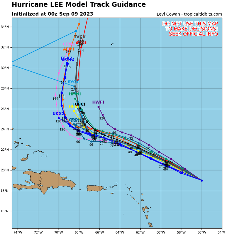
gatorcane wrote:Almost a NNE movement once it turns with the 00Z guidance:
https://i.postimg.cc/0y8P2hBV/13-L-tracks-00z.png
You think out to sea chances are increasing?
0 likes
Re: ATL: LEE - Models
18z euro ensembles have a couple of those westward members again!
https://weather.us/cyclone-tracks/euro/ ... 8-240.html
https://weather.us/cyclone-tracks/euro/ ... 8-240.html
0 likes
-
floridasun
- Tropical Storm
- Posts: 245
- Joined: Tue Sep 14, 2021 3:59 pm
-
TomballEd
- Category 5
- Posts: 1258
- Age: 62
- Joined: Wed Aug 16, 2023 4:52 pm
- Location: Spring/Klein area, not Tomball
Re: ATL: LEE - Models
Iceresistance wrote:I am surprised that no one mentioned the sub-900 members on the 12z Euro-Ensembles
https://s11.gifyu.com/images/S4SMu.png
https://s11.gifyu.com/images/S4SMu.png
https://s11.gifyu.com/images/S4SMV.png
https://s11.gifyu.com/images/S4SMV.png
Euro ensembles are the same resolution as the op. Pro-met who specializes in the tropics thinks 9 km is to high a grid resolution for a global.
0 likes
-
Hybridstorm_November2001

- S2K Supporter
- Posts: 2817
- Joined: Sat Aug 21, 2004 2:50 pm
- Location: SW New Brunswick, Canada
- Contact:
Re: ATL: LEE - Models
The trend sucks for those in Nova Scotia but it would be relatively good news for those of us further west. Typically transitioning tropical systems up here have light winds on the western side of the circulation, especially more than 30-40 miles away from what once was the eye. We might still receive gale-force wind gusts with a central or eastern NS landfall and lots of rain but nothing extremely dangerous.
Damn, poor Nova Scotia is becoming the Florida of the North. They seem to get a landfall from at least a Cat 2 equivalent post-tropical system every season now.
Damn, poor Nova Scotia is becoming the Florida of the North. They seem to get a landfall from at least a Cat 2 equivalent post-tropical system every season now.
2 likes
-
RevanTheJedi96
- Tropical Storm
- Posts: 106
- Joined: Wed Sep 01, 2021 10:40 am
Re: ATL: LEE - Models
Hybridstorm_November2001 wrote:The trend sucks for those in Nova Scotia but it would be relatively good news for those of us further west. Typically transitioning tropical systems up here have light winds on the western side of the circulation, especially more than 30-40 miles away from what once was the eye. We might still receive gale-force wind gusts with a central or eastern NS landfall and lots of rain but nothing extremely dangerous.
Damn, poor Nova Scotia is becoming the Florida of the North. They seem to get a landfall from at least a Cat 2 equivalent post-tropical system every season now.
Downeast Maine would get clobbered in some of those Euro and GFS model runs tho
0 likes
-
Hybridstorm_November2001
- S2K Supporter
- Posts: 2817
- Joined: Sat Aug 21, 2004 2:50 pm
- Location: SW New Brunswick, Canada
- Contact:
Re: ATL: LEE - Models
RevanTheJedi96 wrote:Hybridstorm_November2001 wrote:The trend sucks for those in Nova Scotia but it would be relatively good news for those of us further west. Typically transitioning tropical systems up here have light winds on the western side of the circulation, especially more than 30-40 miles away from what once was the eye. We might still receive gale-force wind gusts with a central or eastern NS landfall and lots of rain but nothing extremely dangerous.
Damn, poor Nova Scotia is becoming the Florida of the North. They seem to get a landfall from at least a Cat 2 equivalent post-tropical system every season now.
Downeast Maine would get clobbered in some of those Euro and GFS model runs tho
Indeed, but I've noticed the models overall trend and consensus models are for a Nova Scotia landfall. That could change but things appear to be trending that way - meaning further east with time. If it verifies it'll be astounding as NS gets clobbered every year now.
0 likes
-
PavelGaborik10
- Category 1
- Posts: 472
- Joined: Tue Sep 04, 2018 3:23 pm
Re: ATL: LEE - Models
Hybridstorm_November2001 wrote:RevanTheJedi96 wrote:Hybridstorm_November2001 wrote:The trend sucks for those in Nova Scotia but it would be relatively good news for those of us further west. Typically transitioning tropical systems up here have light winds on the western side of the circulation, especially more than 30-40 miles away from what once was the eye. We might still receive gale-force wind gusts with a central or eastern NS landfall and lots of rain but nothing extremely dangerous.
Damn, poor Nova Scotia is becoming the Florida of the North. They seem to get a landfall from at least a Cat 2 equivalent post-tropical system every season now.
Downeast Maine would get clobbered in some of those Euro and GFS model runs tho
Indeed, but I've noticed the models overall trend and consensus models are for a Nova Scotia landfall. That could change but things appear to be trending that way - meaning further east with time. If it verifies it'll be astounding as NS gets clobbered every year now.
While I generally agree, it's still so far out.
I wouldn't be surprised at all to see Lee pass to the east of Nova Scotia, offshore when all things are said and done.
1 likes
-
Hybridstorm_November2001
- S2K Supporter
- Posts: 2817
- Joined: Sat Aug 21, 2004 2:50 pm
- Location: SW New Brunswick, Canada
- Contact:
Re: ATL: LEE - Models
PavelGaborik10 wrote:Hybridstorm_November2001 wrote:RevanTheJedi96 wrote:
Downeast Maine would get clobbered in some of those Euro and GFS model runs tho
Indeed, but I've noticed the models overall trend and consensus models are for a Nova Scotia landfall. That could change but things appear to be trending that way - meaning further east with time. If it verifies it'll be astounding as NS gets clobbered every year now.
While I generally agree, it's still so far out.
I wouldn't be surprised at all to see Lee pass to the east of Nova Scotia, offshore when all things are said and done.
That would be by far the best long-range outcome
 , of course, there is still Bermuda to worry about.
1 likes
-
RevanTheJedi96
- Tropical Storm
- Posts: 106
- Joined: Wed Sep 01, 2021 10:40 am
Re: ATL: LEE - Models
Hybridstorm_November2001 wrote:RevanTheJedi96 wrote:Hybridstorm_November2001 wrote:The trend sucks for those in Nova Scotia but it would be relatively good news for those of us further west. Typically transitioning tropical systems up here have light winds on the western side of the circulation, especially more than 30-40 miles away from what once was the eye. We might still receive gale-force wind gusts with a central or eastern NS landfall and lots of rain but nothing extremely dangerous.
Damn, poor Nova Scotia is becoming the Florida of the North. They seem to get a landfall from at least a Cat 2 equivalent post-tropical system every season now.
Downeast Maine would get clobbered in some of those Euro and GFS model runs tho
Indeed, but I've noticed the models overall trend and consensus models are for a Nova Scotia landfall. That could change but things appear to be trending that way - meaning further east with time. If it verifies it'll be astounding as NS gets clobbered every year now.
No I get what you're saying. GFS and Euro strongly agree on a Nova Scoria landfall. Newest GFS falls in line with that.
0 likes
Re: ATL: LEE - Models
Was this just luck or was there skill by the 12Z UKMET in predicting a 22 mb rise in SLP from this morning til this evening?
12Z UK
HURRICANE LEE ANALYSED POSITION : 18.2N 54.1W
ATCF IDENTIFIER : AL132023
LEAD CENTRAL MAXIMUM WIND
VERIFYING TIME TIME POSITION PRESSURE (MB) SPEED (KNOTS)
-------------- ---- -------- ------------- -------------
1200UTC 08.09.2023 0 18.2N 54.1W 941 112
0000UTC 09.09.2023 12 19.6N 56.3W 963 79
1200UTC 09.09.2023 24 20.3N 58.3W 972 70
0000UTC 10.09.2023 36 20.9N 59.8W 975 62
1200UTC 10.09.2023 48 21.6N 61.2W 974 57
0000UTC 11.09.2023 60 22.2N 62.6W 969 68
1200UTC 11.09.2023 72 23.0N 64.2W 964 69
0000UTC 12.09.2023 84 23.6N 65.7W 959 75
1200UTC 12.09.2023 96 24.0N 67.3W 958 78
0000UTC 13.09.2023 108 24.2N 68.4W 951 81
1200UTC 13.09.2023 120 24.8N 69.3W 949 83
0000UTC 14.09.2023 132 25.6N 69.6W 945 86
1200UTC 14.09.2023 144 26.8N 70.1W 954 75
0000UTC 15.09.2023 156 27.9N 70.0W 949 73
1200UTC 15.09.2023 168 29.5N 69.7W 950 73
0 likes
Personal Forecast Disclaimer:
The posts in this forum are NOT official forecasts and should not be used as such. They are just the opinion of the poster and may or may not be backed by sound meteorological data. They are NOT endorsed by any professional institution or storm2k.org. For official information, please refer to the NHC and NWS products.
The posts in this forum are NOT official forecasts and should not be used as such. They are just the opinion of the poster and may or may not be backed by sound meteorological data. They are NOT endorsed by any professional institution or storm2k.org. For official information, please refer to the NHC and NWS products.
Re: ATL: LEE - Models
0Z UK never gets W of 67.7W vs prior run's 70.1W. As a result this passes much closer to Bermuda vs where recent runs were aiming:
HURRICANE LEE ANALYSED POSITION : 19.1N 55.8W
ATCF IDENTIFIER : AL132023
LEAD CENTRAL MAXIMUM WIND
VERIFYING TIME TIME POSITION PRESSURE (MB) SPEED (KNOTS)
-------------- ---- -------- ------------- -------------
0000UTC 09.09.2023 0 19.1N 55.8W 958 83
1200UTC 09.09.2023 12 20.3N 57.4W 966 77
0000UTC 10.09.2023 24 21.2N 58.8W 970 69
1200UTC 10.09.2023 36 21.9N 60.0W 970 62
0000UTC 11.09.2023 48 22.6N 61.1W 970 66
1200UTC 11.09.2023 60 23.2N 62.5W 968 69
0000UTC 12.09.2023 72 23.7N 63.6W 964 72
1200UTC 12.09.2023 84 23.9N 65.0W 957 80
0000UTC 13.09.2023 96 24.2N 65.9W 952 77
1200UTC 13.09.2023 108 24.5N 66.8W 948 81
0000UTC 14.09.2023 120 24.9N 67.2W 950 79
1200UTC 14.09.2023 132 25.9N 67.7W 951 79
0000UTC 15.09.2023 144 27.5N 67.3W 947 80
1200UTC 15.09.2023 156 29.5N 67.7W 946 79
0000UTC 16.09.2023 168 31.4N 67.5W 944 76
0 likes
Personal Forecast Disclaimer:
The posts in this forum are NOT official forecasts and should not be used as such. They are just the opinion of the poster and may or may not be backed by sound meteorological data. They are NOT endorsed by any professional institution or storm2k.org. For official information, please refer to the NHC and NWS products.
The posts in this forum are NOT official forecasts and should not be used as such. They are just the opinion of the poster and may or may not be backed by sound meteorological data. They are NOT endorsed by any professional institution or storm2k.org. For official information, please refer to the NHC and NWS products.
Who is online
Users browsing this forum: No registered users and 4 guests