

Lee has now formed a feeder band.
Not seen previously.
Looks like coming from the east Carib.
High OHC water there creating a high TPW feed.
So, LEE now has two aerial feeds, and a direct water feed as well.
Moving into a well structured anticyclonic wave brake.
Not much to hold Lee back from reintenstification.
ATL: LEE - Post-Tropical - Discussion
Moderator: S2k Moderators

Re: ATL: LEE - Hurricane - Discussion
It’s still remarkable how poorly forecast this burst of shear was and how impactful it ended up being. Great call the other night GCANE.
5 likes
Irene '11 Sandy '12 Hermine '16 5/15/2018 Derecho Fay '20 Isaias '20 Elsa '21 Henri '21 Ida '21
I am only a meteorology enthusiast who knows a decent amount about tropical cyclones. Look to the professional mets, the NHC, or your local weather office for the best information.
I am only a meteorology enthusiast who knows a decent amount about tropical cyclones. Look to the professional mets, the NHC, or your local weather office for the best information.
Re: ATL: LEE - Hurricane - Discussion
aspen wrote:It’s still remarkable how poorly forecast this burst of shear was and how impactful it ended up being. Great call the other night GCANE.
Much thanks Aspen
0 likes

Re: ATL: LEE - Hurricane - Discussion
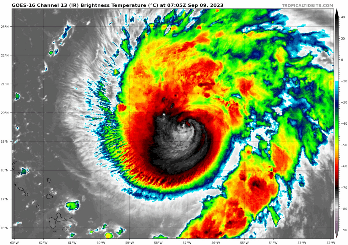
Teban54 wrote:Lee is intensifying again. The eye is back, and it's wasting no time pumping out -90C convective bursts. Looks like there could still be some N or NE shear (don't quote me on that) as that side of the CDO is a bit thin, but it's well ahead of schedule as the NHC didn't expect shear to abate or for Lee to reintensify for another 24 hours.
https://i.postimg.cc/Vvvt5q76/goes16-ir-13-L-202309090705.gif
Looks like that didn't last long before they got blasted off by shear again. Eye no longer seen on IR.
0 likes
TC naming lists: retirements and intensity
Most aggressive Advisory #1's in North Atlantic (cr. kevin for starting the list)
Most aggressive Advisory #1's in North Atlantic (cr. kevin for starting the list)
Re: ATL: LEE - Hurricane - Discussion
Pressure is down on the first pass from the NOAA plane. 956/38 eye drop. There’s also more support for major hurricane winds this time.
0 likes
Irene '11 Sandy '12 Hermine '16 5/15/2018 Derecho Fay '20 Isaias '20 Elsa '21 Henri '21 Ida '21
I am only a meteorology enthusiast who knows a decent amount about tropical cyclones. Look to the professional mets, the NHC, or your local weather office for the best information.
I am only a meteorology enthusiast who knows a decent amount about tropical cyclones. Look to the professional mets, the NHC, or your local weather office for the best information.
-
cycloneye

- Admin

- Posts: 148718
- Age: 69
- Joined: Thu Oct 10, 2002 10:54 am
- Location: San Juan, Puerto Rico
Re: ATL: LEE - Hurricane - Discussion
After 12 hours eye not being closed, is now.
URNT12 KWBC 091044
VORTEX DATA MESSAGE AL132023
A. 09/10:13:18Z
B. 19.89 deg N 057.57 deg W
C. 700 MB 2761 m
D. 956 mb
E. 090 deg 38 kt
F. CLOSED
G. E09/5/2
H. 89 kt
I. 230 deg 6 nm 10:11:44Z
J. 326 deg 90 kt
K. 230 deg 7 nm 10:11:27Z
L. 100 kt
M. 060 deg 6 nm 10:14:45Z
N. 143 deg 103 kt
O. 061 deg 8 nm 10:15:13Z
P. 14 C / 3096 m
Q. 23 C / 2840 m
R. 18 C / NA
S. 124 / 7
T. 0.01 / 2 nm
U. NOAA3 0713A LEE OB 05
RAGGED EYE
MAX FL WIND 103 KT 061 / 8 NM 10:15:13Z
MAX FL TEMP 25 C 231 / 6 NM FROM FL CNTR
0 likes
Visit the Caribbean-Central America Weather Thread where you can find at first post web cams,radars
and observations from Caribbean basin members Click Here
and observations from Caribbean basin members Click Here
Re: ATL: LEE - Hurricane - Discussion
Eye Character: Closed
Eye Shape: Elliptical (oval shaped)
Orientation of Major Axis in Elliptical Eye: 90° to 270° (E to W)
Length of Major Axis in Elliptical Eye: 5 nautical miles
Length of Minor Axis in Elliptical Eye: 2 nautical miles
Eye Shape: Elliptical (oval shaped)
Orientation of Major Axis in Elliptical Eye: 90° to 270° (E to W)
Length of Major Axis in Elliptical Eye: 5 nautical miles
Length of Minor Axis in Elliptical Eye: 2 nautical miles
0 likes
Re: ATL: LEE - Hurricane - Discussion
Relatively dry eye drop. pinhole eye, cloud tops warming.
Probability of EWRC going up
https://tropic.ssec.wisc.edu/real-time/ ... leERC.html
Probability of EWRC going up
https://tropic.ssec.wisc.edu/real-time/ ... leERC.html
1 likes
Re: ATL: LEE - Hurricane - Discussion
AF just avoided the eye and NOAA has already left after just one pass, so I guess the strong mesovorts are still a problem.
0 likes
Irene '11 Sandy '12 Hermine '16 5/15/2018 Derecho Fay '20 Isaias '20 Elsa '21 Henri '21 Ida '21
I am only a meteorology enthusiast who knows a decent amount about tropical cyclones. Look to the professional mets, the NHC, or your local weather office for the best information.
I am only a meteorology enthusiast who knows a decent amount about tropical cyclones. Look to the professional mets, the NHC, or your local weather office for the best information.

Re: ATL: LEE - Hurricane - Discussion
30 min loop of Lee Geo Colour and IR. Seeing a burst of convection happening and a lot of lightning happening could be intensifimg.
Source - https://col.st/O2brc

Source - https://col.st/O2brc
4 likes
-
cycloneye
- Admin
- Posts: 148718
- Age: 69
- Joined: Thu Oct 10, 2002 10:54 am
- Location: San Juan, Puerto Rico
Re: ATL: LEE - Hurricane - Discussion
Hopefully, all is fine with the crew of the NOAA plane that has left with only one pass. Air Force plane is there.
3 likes
Visit the Caribbean-Central America Weather Thread where you can find at first post web cams,radars
and observations from Caribbean basin members Click Here
and observations from Caribbean basin members Click Here
-
InfernoFlameCat

- Category 5

- Posts: 2127
- Age: 22
- Joined: Mon Dec 14, 2020 10:52 am
- Location: Buford, GA
Re: ATL: LEE - Hurricane - Discussion
That shear is taking a serious toll on the hurricane. It looks like it’s dropped below major hurricane status.
0 likes
I am by no means a professional. DO NOT look at my forecasts for official information or make decisions based on what I post.
Goal: to become a registered expert over tropical and subtropical cyclones.
Goal: to become a registered expert over tropical and subtropical cyclones.
-
cycloneye
- Admin
- Posts: 148718
- Age: 69
- Joined: Thu Oct 10, 2002 10:54 am
- Location: San Juan, Puerto Rico
Re: ATL: LEE - Hurricane - Discussion
Still cat 3.
AL, 13, 2023090912, , BEST, 0, 200N, 578W, 100, 954, HU
0 likes
Visit the Caribbean-Central America Weather Thread where you can find at first post web cams,radars
and observations from Caribbean basin members Click Here
and observations from Caribbean basin members Click Here
-
WeatherBoy2000
- Category 1

- Posts: 456
- Joined: Mon Apr 10, 2023 9:29 am
Re: ATL: LEE - Hurricane - Discussion
It still looks like a mess on satellite but the weakening trend has stopped. The fact that it is now down below 960mb again might be a sign that it is trying to reorganize again.
0 likes
Re: ATL: LEE - Hurricane - Discussion
InfernoFlameCat wrote:That shear is taking a serious toll on the hurricane. It looks like it’s dropped below major hurricane status.
It’s actually stronger than last night. Recon found pressures in the low-mid 950s, about 10mb lower than the final overnight passes. It sure looks like a train wreck on visible, though.
0 likes
Irene '11 Sandy '12 Hermine '16 5/15/2018 Derecho Fay '20 Isaias '20 Elsa '21 Henri '21 Ida '21
I am only a meteorology enthusiast who knows a decent amount about tropical cyclones. Look to the professional mets, the NHC, or your local weather office for the best information.
I am only a meteorology enthusiast who knows a decent amount about tropical cyclones. Look to the professional mets, the NHC, or your local weather office for the best information.
Re: ATL: LEE - Hurricane - Discussion
Margot is creating a poleward outflow channel for Lee
The more Margot strengthens the better the ventilation for Lee
The more Margot strengthens the better the ventilation for Lee
0 likes
-
cheezyWXguy

- Category 5
- Posts: 6242
- Joined: Mon Feb 13, 2006 12:29 am
- Location: Dallas, TX
Re: ATL: LEE - Hurricane - Discussion
At a time on Thursday Lee was about the best looking cat2 I’ve ever seen, and now it’s about the ugliest cat3 I’ve ever seen. Just goes to show the value of recon.
I haven’t seen any mw passes in a while, but vis imagery suggests an outer eyewall has wrapped around most of the core, except maybe to the south where the shear is coming from. If so, I wouldn’t expect any strengthening today until the inevitable ERC completes, but I do think the weakening has stopped.
I haven’t seen any mw passes in a while, but vis imagery suggests an outer eyewall has wrapped around most of the core, except maybe to the south where the shear is coming from. If so, I wouldn’t expect any strengthening today until the inevitable ERC completes, but I do think the weakening has stopped.
1 likes
-
WalterWhite

- Category 1
- Posts: 342
- Joined: Fri Mar 17, 2023 5:53 pm
Re: ATL: LEE - Hurricane - Discussion
Based on recon so far, Lee could possibly be a Category I hurricane.
0 likes

Re: ATL: LEE - Hurricane - Discussion
IR presentation looked a lot better last night but now it looks like crap again.
0 likes
Igor 2010, Sandy 2012, Fay 2014, Gonzalo 2014, Joaquin 2015, Nicole 2016, Humberto 2019, Imelda 2025
I am only a tropical weather enthusiast. My predictions are not official and may or may not be backed by sound meteorological data. For official information, please refer to the NHC and NWS products.
I am only a tropical weather enthusiast. My predictions are not official and may or may not be backed by sound meteorological data. For official information, please refer to the NHC and NWS products.
Who is online
Users browsing this forum: No registered users and 10 guests