
ATL: LEE - Post-Tropical - Discussion
Moderator: S2k Moderators
-
Sciencerocks
- Category 5

- Posts: 10181
- Age: 40
- Joined: Thu Jul 06, 2017 1:51 am
-
tolakram
- Admin

- Posts: 20179
- Age: 62
- Joined: Sun Aug 27, 2006 8:23 pm
- Location: Florence, KY (name is Mark)
Re: ATL: LEE - Hurricane - Discussion
Ocean heat content map. I'm using the equivalent map here which is a little more extreme, but honestly not sure which one to use. Regardless, as Lee moves north, depending on where it moves, heat will run out.

source: http://isotherm.rsmas.miami.edu/heat/weba/atlantic.php
source: http://isotherm.rsmas.miami.edu/heat/weba/atlantic.php
4 likes
M a r k
- - - - -
Join us in chat: Storm2K Chatroom Invite. Android and IOS apps also available.
The posts in this forum are NOT official forecasts and should not be used as such. Posts are NOT endorsed by any professional institution or STORM2K.org. For official information and forecasts, please refer to NHC and NWS products.


Re: ATL: LEE - Hurricane - Discussion
I like to use the UW site after clicking the storm, then choosing SST (Reynolds dataset.) Lee roughly has 48 hours of ideal OHC, once that north movement is in then it will quickly (picks up speed) hit cooler waters at the same time will start merging with trough.

http://tropic.ssec.wisc.edu/#
http://tropic.ssec.wisc.edu/#
1 likes
The above post and any post by Ntxw is NOT an official forecast and should not be used as such. It is just the opinion of the poster and may or may not be backed by sound meteorological data. It is NOT endorsed by any professional institution including Storm2k. For official information, please refer to NWS products.
Help support Storm2K!


Re: ATL: LEE - Hurricane - Discussion
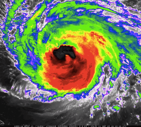
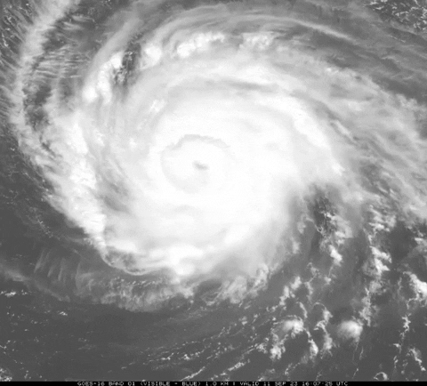
Hurricane2022 wrote:the inner eyewall is almost gone on VIS now.
Nope, it’s flaring up a lot now.
1 likes
Irene '11 Sandy '12 Hermine '16 5/15/2018 Derecho Fay '20 Isaias '20 Elsa '21 Henri '21 Ida '21
I am only a meteorology enthusiast who knows a decent amount about tropical cyclones. Look to the professional mets, the NHC, or your local weather office for the best information.
I am only a meteorology enthusiast who knows a decent amount about tropical cyclones. Look to the professional mets, the NHC, or your local weather office for the best information.
-
cycloneye

- Admin
- Posts: 149275
- Age: 69
- Joined: Thu Oct 10, 2002 10:54 am
- Location: San Juan, Puerto Rico
Re: ATL: LEE - Hurricane - Discussion
aspen wrote:Hurricane2022 wrote:the inner eyewall is almost gone on VIS now.
Nope, it’s flaring up a lot now.
Air force plane will arrive soon to verifie.
0 likes
Visit the Caribbean-Central America Weather Thread where you can find at first post web cams,radars
and observations from Caribbean basin members Click Here
and observations from Caribbean basin members Click Here
Re: ATL: LEE - Hurricane - Discussion
I haven't seen any correlations to Sandy raking the east coast. To me seems eerily similar albeit further north. However the topography of Maine and New Brunswick is considerably different for storm surge. It seems with the rocky coastline, that tides surges would be pushed up even higher as they cannot spread out like they do along the gulf coast. Is that a valid assumption?
2 likes
-
ElectricStorm

- Category 5
- Posts: 5140
- Age: 25
- Joined: Tue Aug 13, 2019 11:23 pm
- Location: Norman, OK
Re: ATL: LEE - Hurricane - Discussion
Nice new burst on the north side, we'll see if it can wrap around
0 likes
B.S Meteorology, University of Oklahoma '25
Please refer to the NHC, NWS, or SPC for official information.
Please refer to the NHC, NWS, or SPC for official information.
-
cheezyWXguy

- Category 5
- Posts: 6281
- Joined: Mon Feb 13, 2006 12:29 am
- Location: Dallas, TX
Re: ATL: LEE - Hurricane - Discussion
This is the inner eyewall’s last gasp. This seems to be be common in more significant ERCs. I wonder if it either results in further delay, or “functions” to sharpen the pressure gradient or constrict the outer eyewall before it takes over the the inner falls away. Any insight from someone who knows more about ERCs is appreciated.
0 likes
-
sicktght311
- Tropical Depression

- Posts: 86
- Joined: Thu Sep 02, 2010 11:31 am
Re: ATL: LEE - Hurricane - Discussion
Looks like a new eye is trying to reform on IR and Satellite. Lets see if this one holds together
0 likes

Re: ATL: LEE - Hurricane - Discussion
Wondering if a storm surge scenario were to potentially occur up here due to the track how Chignecto region would fare, if the surge would actually funnel all the way up the bay to here. I'm currently in the Tantramar area, I'm not too worried about power outages for me personally even if wind was still a problem because I'm only half a kilometer from the substation and held power during Fiona, but seeing a surge could be a sticky situation especially considering this is marshland.
I believe this area was inudated with surge about 150 years ago so it's possible for it to funnel up to here, the TransCanada freeway also crosses here so that's a major transportation link to NS.
I believe this area was inudated with surge about 150 years ago so it's possible for it to funnel up to here, the TransCanada freeway also crosses here so that's a major transportation link to NS.
0 likes
My Storms:
Earl 2010, Arthur 2014, Dorian 2019, Teddy 2020 and Fiona 2022
Storms that had a major impact on my area are bolded.
Earl 2010, Arthur 2014, Dorian 2019, Teddy 2020 and Fiona 2022
Storms that had a major impact on my area are bolded.
Re: ATL: LEE - Hurricane - Discussion
The first eyewall penetration by the latest AF plane shows that the outer eyewall is significantly stronger than the stubborn inner eyewall. The extrap pressure seems to be around 945 mb.
0 likes
Irene '11 Sandy '12 Hermine '16 5/15/2018 Derecho Fay '20 Isaias '20 Elsa '21 Henri '21 Ida '21
I am only a meteorology enthusiast who knows a decent amount about tropical cyclones. Look to the professional mets, the NHC, or your local weather office for the best information.
I am only a meteorology enthusiast who knows a decent amount about tropical cyclones. Look to the professional mets, the NHC, or your local weather office for the best information.

Re: ATL: LEE - Hurricane - Discussion
aspen wrote:The first eyewall penetration by the latest AF plane shows that the outer eyewall is significantly stronger than the stubborn inner eyewall. The extrap pressure seems to be around 945 mb.
GOES image is running behind and stuck at 1655z on both Tropical Tidbits and Weather Nerds, so it's quite possible that significant structural changes happened during the 2 hours before recon that made the outer eyewall take over.
0 likes
TC naming lists: retirements and intensity
Most aggressive Advisory #1's in North Atlantic (cr. kevin for starting the list)
Most aggressive Advisory #1's in North Atlantic (cr. kevin for starting the list)
-
REDHurricane

- Category 1

- Posts: 438
- Age: 28
- Joined: Sun Jul 03, 2022 2:36 pm
- Location: Northeast Pacific Ocean
-
cheezyWXguy
- Category 5
- Posts: 6281
- Joined: Mon Feb 13, 2006 12:29 am
- Location: Dallas, TX
Re: ATL: LEE - Hurricane - Discussion
REDHurricane wrote:https://media4.giphy.com/media/v1.Y2lkPTc5MGI3NjExY3NzY3ExNWxodm0yNmZjaDR1MTd2ZHM2NDEwMWJ6M3htaHoxdW83biZlcD12MV9pbnRlcm5hbF9naWZfYnlfaWQmY3Q9Zw/iVrEax0ftrJTUVTh3l/giphy.gif
https://media4.giphy.com/media/v1.Y2lkPTc5MGI3NjExdzMybDFvbjYyMHQwZDBqbHhtandkbTBpaHluZWUyNHJ1anA0NjNzcyZlcD12MV9pbnRlcm5hbF9naWZfYnlfaWQmY3Q9Zw/EjPVQYW3cwruzgB9uv/giphy.gif
Inner eyewall hanging on for dear life but it won’t be long now
0 likes
-
Sciencerocks
- Category 5
- Posts: 10181
- Age: 40
- Joined: Thu Jul 06, 2017 1:51 am

-
ScottNAtlanta

- Category 5
- Posts: 2535
- Joined: Sat May 25, 2013 3:11 pm
- Location: Atlanta, GA
Re: ATL: LEE - Hurricane - Discussion
Has anyone seen the buoys that recon has dropped that measure the temperature of the surface water and how far down it is to the 26c isotherm? I just noticed it on mission 16. The 2 drops had depth of 26c water at 75 meters and 97 meters. Is that something new? I don't remember ever seeing it.
0 likes
The posts in this forum are NOT official forecast and should not be used as such. They are just the opinion of the poster and may or may not be backed by sound meteorological data. They are NOT endorsed by any professional institution or storm2k.org. For official information, please refer to the NHC and NWS products.
-
cycloneye
- Admin
- Posts: 149275
- Age: 69
- Joined: Thu Oct 10, 2002 10:54 am
- Location: San Juan, Puerto Rico
Re: ATL: LEE - Hurricane - Discussion
No more forecast of being again cat 4.
INIT 11/2100Z 23.6N 64.2W 100 KT 115 MPH
12H 12/0600Z 24.0N 65.1W 105 KT 120 MPH
24H 12/1800Z 24.6N 66.1W 105 KT 120 MPH
36H 13/0600Z 25.3N 66.9W 100 KT 115 MPH
48H 13/1800Z 26.5N 67.5W 100 KT 115 MPH
60H 14/0600Z 28.3N 67.8W 95 KT 110 MPH
72H 14/1800Z 30.3N 67.9W 90 KT 105 MPH
96H 15/1800Z 35.4N 67.1W 80 KT 90 MPH
120H 16/1800Z 40.8N 67.0W 65 KT 75 MPH
3 likes
Visit the Caribbean-Central America Weather Thread where you can find at first post web cams,radars
and observations from Caribbean basin members Click Here
and observations from Caribbean basin members Click Here
-
Sciencerocks
- Category 5
- Posts: 10181
- Age: 40
- Joined: Thu Jul 06, 2017 1:51 am
-
zal0phus

- Tropical Storm

- Posts: 201
- Age: 25
- Joined: Mon Jan 07, 2019 8:32 am
- Location: St. Louis
- Contact:
Re: ATL: LEE - Hurricane - Discussion
cycloneye wrote:No more forecast of being again cat 4.
INIT 11/2100Z 23.6N 64.2W 100 KT 115 MPH
12H 12/0600Z 24.0N 65.1W 105 KT 120 MPH
24H 12/1800Z 24.6N 66.1W 105 KT 120 MPH
36H 13/0600Z 25.3N 66.9W 100 KT 115 MPH
48H 13/1800Z 26.5N 67.5W 100 KT 115 MPH
60H 14/0600Z 28.3N 67.8W 95 KT 110 MPH
72H 14/1800Z 30.3N 67.9W 90 KT 105 MPH
96H 15/1800Z 35.4N 67.1W 80 KT 90 MPH
120H 16/1800Z 40.8N 67.0W 65 KT 75 MPH
Strong Larry 2021 influence
0 likes
Do not take anything I say seriously as a form of meteorological prediction. I am not a meteorologist; I don't think being in law school translates to any special knowledge. I am just a somewhat bullish amateur watcher.
Re: ATL: LEE - Hurricane - Discussion
Wow this thread is pretty dead I guess it’s because the track is pretty locked into Atlantic Canada or New England.
2 likes
Who is online
Users browsing this forum: No registered users and 63 guests