ATL: TAMMY - Models
Moderator: S2k Moderators


2023 Global Model Runs Discussion (Out thru day 16)
A definite change from the MDR tracks we have been seeing all summer if it comes to fruition.
4 likes

Re: ATL: INVEST 94L - Models
Zonacane wrote:Might be our first Caribbean cruiser since 2007
Maria 2017 reached its 150 kt / 908 mb peak in the Caribbean. And the Euro ensemble tracks shown above are quite similar to Maria's, if it recurves early enough to "just" clip the NE Caribbean.
0 likes
TC naming lists: retirements and intensity
Most aggressive Advisory #1's in North Atlantic (cr. kevin for starting the list)
Most aggressive Advisory #1's in North Atlantic (cr. kevin for starting the list)
-
cycloneye

- Admin

- Posts: 149730
- Age: 69
- Joined: Thu Oct 10, 2002 10:54 am
- Location: San Juan, Puerto Rico
Re: 2023 Global Model Runs Discussion (Out thru day 16)
MetroMike wrote:A definite change from the MDR tracks we have been seeing all summer if it comes to fruition.
Moved your post from the global models discussion thread to here.
0 likes
Visit the Caribbean-Central America Weather Thread where you can find at first post web cams,radars
and observations from Caribbean basin members Click Here
and observations from Caribbean basin members Click Here
Re: ATL: INVEST 94L - Models
Teban54 wrote:Zonacane wrote:Might be our first Caribbean cruiser since 2007
Maria 2017 reached its 150 kt / 908 mb peak in the Caribbean. And the Euro ensemble tracks shown above are quite similar to Maria's, if it recurves early enough to "just" clip the NE Caribbean.
Looks like we have our next beefy major hurricane regardless of track.
0 likes
-
tolakram
- Admin
- Posts: 20186
- Age: 62
- Joined: Sun Aug 27, 2006 8:23 pm
- Location: Florence, KY (name is Mark)
Re: ATL: INVEST 94L - Models
I remember when the models said Phil would be a major. 
9 likes
M a r k
- - - - -
Join us in chat: Storm2K Chatroom Invite. Android and IOS apps also available.
The posts in this forum are NOT official forecasts and should not be used as such. Posts are NOT endorsed by any professional institution or STORM2K.org. For official information and forecasts, please refer to NHC and NWS products.
Re: ATL: INVEST 94L - Models
tolakram wrote:I remember when the models said Phil would be a major.
On the other hand, virtually no models had Lidia bomb out to a Cat 4 just before its Mexico landfall. So I guess we can only wait and see.
6 likes
TC naming lists: retirements and intensity
Most aggressive Advisory #1's in North Atlantic (cr. kevin for starting the list)
Most aggressive Advisory #1's in North Atlantic (cr. kevin for starting the list)
-
Hurricane2022

- Category 5

- Posts: 2093
- Joined: Tue Aug 23, 2022 11:38 pm
- Location: Araçatuba, Brazil
Re: ATL: INVEST 94L - Models
tolakram wrote:I remember when the models said Phil would be a major.
And Nigel.
3 likes
Sorry for the bad English sometimes...!
For reliable and detailed information for any meteorological phenomenon, please consult the National Hurricane Center, Joint Typhoon Warning Center , or your local Meteo Center.
--------
ECCE OMNIA NOVA FACIAM (Ap 21,5).
For reliable and detailed information for any meteorological phenomenon, please consult the National Hurricane Center, Joint Typhoon Warning Center , or your local Meteo Center.
--------
ECCE OMNIA NOVA FACIAM (Ap 21,5).
Re: ATL: INVEST 94L - Models
Once again 18z GFS shows weird monsoon trough interaction. I do not trust it at all.
2 likes
-
Blown Away

- S2K Supporter

- Posts: 10253
- Joined: Wed May 26, 2004 6:17 am
Re: ATL: INVEST 94L - Models
12z ECENS… Dang that’s a strong signal.
1 likes
Hurricane Eye Experience: David 79, Irene 99, Frances 04, Jeanne 04, Wilma 05… Hurricane Brush Experience: Andrew 92, Erin 95, Floyd 99, Matthew 16, Irma 17, Ian 22, Nicole 22…

Re: ATL: INVEST 94L - Models
zzzh wrote:Once again 18z GFS shows weird monsoon trough interaction. I do not trust it at all.
This is looking like Franklin, Idalia, and Lee all over again: GFS keeps killing the disturbance while the other globals develop it, and eventually the GFS caves.
6 likes
Irene '11 Sandy '12 Hermine '16 5/15/2018 Derecho Fay '20 Isaias '20 Elsa '21 Henri '21 Ida '21
I am only a meteorology enthusiast who knows a decent amount about tropical cyclones. Look to the professional mets, the NHC, or your local weather office for the best information.
I am only a meteorology enthusiast who knows a decent amount about tropical cyclones. Look to the professional mets, the NHC, or your local weather office for the best information.
-
USTropics
- Professional-Met

- Posts: 2741
- Joined: Sun Aug 12, 2007 3:45 am
- Location: Florida State University
Re: ATL: INVEST 94L - Models
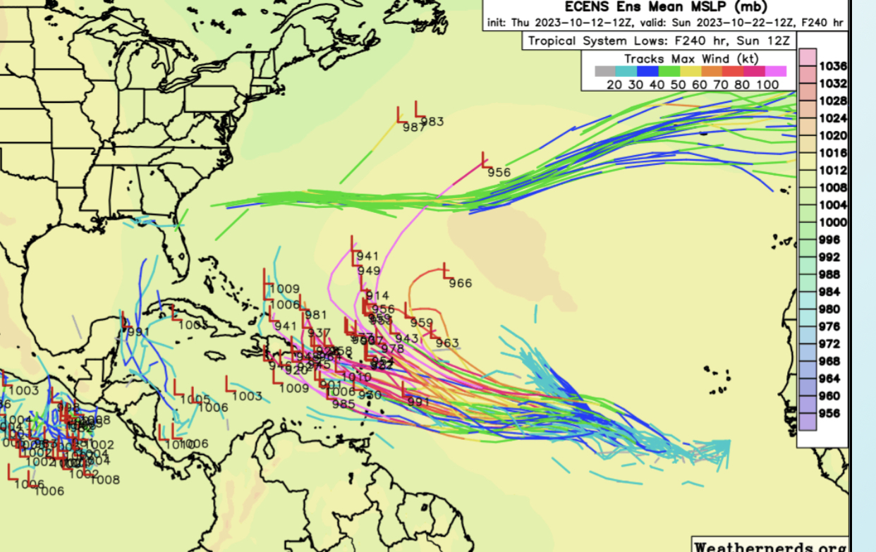
Will be watching this one closely, model trends are starting to look worrisome for the Caribbean islands. The ECMWF and CMC ensemble members show off-the-charts high pressure anomalies over the central Atlantic. Not sure I've ever seen such a setup in mid-late October with the ridge extension that far east:


The GEFS members are starting to correct towards the model consensus, previous runs didn't have quite the extension, which allowed 94L to recurve before running under the ridge:

How much this gains latitude in the next ~72 hours will be important to future track. The operational EMCWF and CMC have quite a noticeable WSW dip due to the amplification of the ridge. It's a little fuzzy with Sean's tracks, but there's become two distinct camps in the ECMWF ensembles:

The GEFS members are starting to correct towards the model consensus, previous runs didn't have quite the extension, which allowed 94L to recurve before running under the ridge:
How much this gains latitude in the next ~72 hours will be important to future track. The operational EMCWF and CMC have quite a noticeable WSW dip due to the amplification of the ridge. It's a little fuzzy with Sean's tracks, but there's become two distinct camps in the ECMWF ensembles:
9 likes
-
cycloneye
- Admin
- Posts: 149730
- Age: 69
- Joined: Thu Oct 10, 2002 10:54 am
- Location: San Juan, Puerto Rico
Re: ATL: INVEST 94L - Models
USTropics wrote:Will be watching this one closely, model trends are starting to look worrisome for the Caribbean islands. The ECMWF and CMC ensemble members show off-the-charts high pressure anomalies over the central Atlantic. Not sure I've ever seen such a setup in mid-late October with the ridge extension that far east:
https://i.imgur.com/uU6kdvB.png
https://i.imgur.com/9e1o9CY.png
The GEFS members are starting to correct towards the model consensus, previous runs didn't have quite the extension, which allowed 94L to recurve before running under the ridge:
https://i.imgur.com/yE17ts5.gif
How much this gains latitude in the next ~72 hours will be important to future track. The operational EMCWF and CMC have quite a noticeable WSW dip due to the amplification of the ridge. It's a little fuzzy with Sean's tracks, but there's become two distinct camps in the ECMWF ensembles:
https://i.imgur.com/nuKDqxk.png
As always, great analysis by you. 18z GFS still went to the north and not do what Euro, CMC did. You think that model will correct to the others?
0 likes
Visit the Caribbean-Central America Weather Thread where you can find at first post web cams,radars
and observations from Caribbean basin members Click Here
and observations from Caribbean basin members Click Here
Re: ATL: INVEST 94L - Models
USTropics wrote:Will be watching this one closely, model trends are starting to look worrisome for the Caribbean islands. The ECMWF and CMC ensemble members show off-the-charts high pressure anomalies over the central Atlantic. Not sure I've ever seen such a setup in mid-late October with the ridge extension that far east:
https://i.imgur.com/uU6kdvB.png
https://i.imgur.com/9e1o9CY.png
The GEFS members are starting to correct towards the model consensus, previous runs didn't have quite the extension, which allowed 94L to recurve before running under the ridge:
https://i.imgur.com/yE17ts5.gif
How much this gains latitude in the next ~72 hours will be important to future track. The operational EMCWF and CMC have quite a noticeable WSW dip due to the amplification of the ridge. It's a little fuzzy with Sean's tracks, but there's become two distinct camps in the ECMWF ensembles:
https://i.imgur.com/nuKDqxk.png
Do you think this could be a us threat possibly? Ensembles supporting something for the eastern gulf next weekend.
0 likes
-
USTropics
- Professional-Met
- Posts: 2741
- Joined: Sun Aug 12, 2007 3:45 am
- Location: Florida State University
Re: ATL: INVEST 94L - Models
cycloneye wrote:USTropics wrote:Will be watching this one closely, model trends are starting to look worrisome for the Caribbean islands. The ECMWF and CMC ensemble members show off-the-charts high pressure anomalies over the central Atlantic. Not sure I've ever seen such a setup in mid-late October with the ridge extension that far east:
https://i.imgur.com/uU6kdvB.png
https://i.imgur.com/9e1o9CY.png
The GEFS members are starting to correct towards the model consensus, previous runs didn't have quite the extension, which allowed 94L to recurve before running under the ridge:
https://i.imgur.com/yE17ts5.gif
How much this gains latitude in the next ~72 hours will be important to future track. The operational EMCWF and CMC have quite a noticeable WSW dip due to the amplification of the ridge. It's a little fuzzy with Sean's tracks, but there's become two distinct camps in the ECMWF ensembles:
https://i.imgur.com/nuKDqxk.png
As always, great analysis by you. 18z GFS still went to the north and not do what Euro, CMC did. You think that model will correct to the others?
I do, you can see the model verification for positioning of 94L is already going to need corrections (which it has done for the last 6 runs as well):

This does a good job of showing how even the furthest south track on the GFS ensembles is still north of verification:

The same can be said about the Euro ensembles, where current verification is in the southern envelope (which has me concerned we see a more southerly track like the red highlighted tracks in my previous post):

6 likes
-
USTropics
- Professional-Met
- Posts: 2741
- Joined: Sun Aug 12, 2007 3:45 am
- Location: Florida State University
Re: ATL: INVEST 94L - Models
Ianswfl wrote:USTropics wrote:Will be watching this one closely, model trends are starting to look worrisome for the Caribbean islands. The ECMWF and CMC ensemble members show off-the-charts high pressure anomalies over the central Atlantic. Not sure I've ever seen such a setup in mid-late October with the ridge extension that far east:
https://i.imgur.com/uU6kdvB.png
https://i.imgur.com/9e1o9CY.png
The GEFS members are starting to correct towards the model consensus, previous runs didn't have quite the extension, which allowed 94L to recurve before running under the ridge:
https://i.imgur.com/yE17ts5.gif
How much this gains latitude in the next ~72 hours will be important to future track. The operational EMCWF and CMC have quite a noticeable WSW dip due to the amplification of the ridge. It's a little fuzzy with Sean's tracks, but there's become two distinct camps in the ECMWF ensembles:
https://i.imgur.com/nuKDqxk.png
Do you think this could be a us threat possibly? Ensembles supporting something for the eastern gulf next weekend.
I don't see any threat to the US from this system currently. All model guidance has a potent shortwave trough moving through Florida on the 20th/21st (which causes a select few ensemble members to form a system in the NW CARIB that moves towards Florida like you mentioned). That same shortwave trough will push off the eastern seaboard and break down any ridging that exists:


Never say never in the tropics (especially at this timeframe), but 94L would really need to get buried in the Caribbean with little to no development to be a threat to the US. Not seeing that in the model guidance, the current focused threat areas should be for islands in the Caribbean.
3 likes
-
IsabelaWeather
- Category 1

- Posts: 316
- Age: 36
- Joined: Tue Jul 07, 2020 7:29 am
- Location: Isabela, Puerto Rico
Re: ATL: INVEST 94L - Models
USTropics wrote:cycloneye wrote:USTropics wrote:Will be watching this one closely, model trends are starting to look worrisome for the Caribbean islands. The ECMWF and CMC ensemble members show off-the-charts high pressure anomalies over the central Atlantic. Not sure I've ever seen such a setup in mid-late October with the ridge extension that far east:
https://i.imgur.com/uU6kdvB.png
https://i.imgur.com/9e1o9CY.png
The GEFS members are starting to correct towards the model consensus, previous runs didn't have quite the extension, which allowed 94L to recurve before running under the ridge:
https://i.imgur.com/yE17ts5.gif
How much this gains latitude in the next ~72 hours will be important to future track. The operational EMCWF and CMC have quite a noticeable WSW dip due to the amplification of the ridge. It's a little fuzzy with Sean's tracks, but there's become two distinct camps in the ECMWF ensembles:
https://i.imgur.com/nuKDqxk.png
As always, great analysis by you. 18z GFS still went to the north and not do what Euro, CMC did. You think that model will correct to the others?
I do, you can see the model verification for positioning of 94L is already going to need corrections (which it has done for the last 6 runs as well):
https://i.imgur.com/45m72cB.png
This does a good job of showing how even the furthest south track on the GFS ensembles is still north of verification:
https://i.imgur.com/UG18v0K.png
The same can be said about the Euro ensembles, where current verification is in the southern envelope (which has me concerned we see a more southerly track like the red highlighted tracks in my previous post):
https://i.imgur.com/k4yojHB.png
Does a more southerly track reduce the chance for a hit here in PR and have it pass to our south? Or will it be curving up WNW towards us as it gets closer?
0 likes
-
floridasun
- Tropical Storm

- Posts: 245
- Joined: Tue Sep 14, 2021 3:59 pm
Re: ATL: INVEST 94L - Models
look like gfs turn 94l out to sea https://www.tropicaltidbits.com/analysi ... 01218&fh=6
0 likes
-
USTropics
- Professional-Met
- Posts: 2741
- Joined: Sun Aug 12, 2007 3:45 am
- Location: Florida State University
Re: ATL: INVEST 94L - Models
IsabelaWeather wrote:USTropics wrote:cycloneye wrote:
As always, great analysis by you. 18z GFS still went to the north and not do what Euro, CMC did. You think that model will correct to the others?
I do, you can see the model verification for positioning of 94L is already going to need corrections (which it has done for the last 6 runs as well):
https://i.imgur.com/45m72cB.png
This does a good job of showing how even the furthest south track on the GFS ensembles is still north of verification:
https://i.imgur.com/UG18v0K.png
The same can be said about the Euro ensembles, where current verification is in the southern envelope (which has me concerned we see a more southerly track like the red highlighted tracks in my previous post):
https://i.imgur.com/k4yojHB.png
Does a more southerly track reduce the chance for a hit here in PR and have it pass to our south? Or will it be curving up WNW towards us as it gets closer?
Based on the current guidance, a more southerly track enhances the threat to Puerto Rico and Hispaniola. The good news is this is a slow moving (and still very disorganized) system, so we have some time to iron those details out. A lot of variables are still in play: how fast this moves, when/where it develops has an impact on trajectory, how far west the ridge digs, and how fast the trough moves in to break it down will be critical. There's still a non-zero chance this completely misses the islands or doesn't develop (although I would say getting lower).
I will also mention the intensity forecast is tricky (will save the specifics on that for another night). It's going to take some time for 94L to fight against the background state, and with that amplification of the ridge, expect plenty of dry, stable air diverging along the northern axis. If it's sufficiently developed by that time though (and shear remains low as some of the model guidance is suggesting), it could find a favorable environment as we've seen with some of the ECWMF ensemble members showing robust strengthening.
2 likes
Re: ATL: INVEST 94L - Models
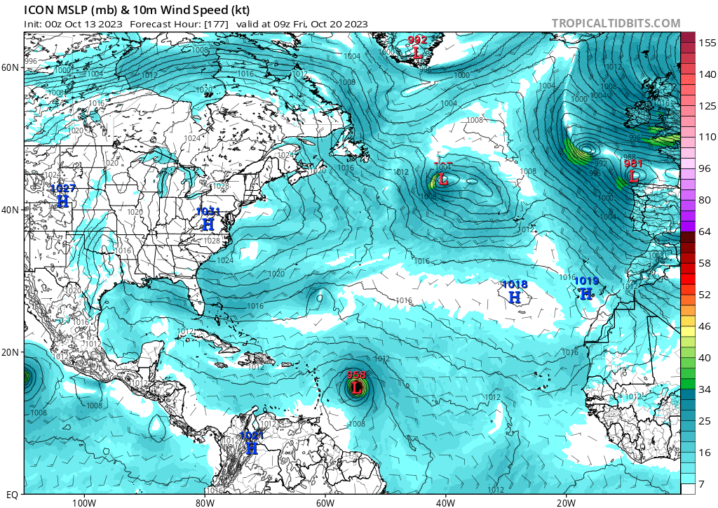
FWIW, 0z ICON has 958 mb in the MDR. Has this ever happened in late October in MDR proper before?
GFS continues to not develop it.
GFS continues to not develop it.
0 likes
TC naming lists: retirements and intensity
Most aggressive Advisory #1's in North Atlantic (cr. kevin for starting the list)
Most aggressive Advisory #1's in North Atlantic (cr. kevin for starting the list)
Who is online
Users browsing this forum: No registered users and 26 guests