2024 Indicators: SST's, MSLP, Shear, SAL, Steering, Instability (Day 16+ Climate Models)
Moderator: S2k Moderators
Forum rules

The posts in this forum are NOT official forecasts and should not be used as such. They are just the opinion of the poster and may or may not be backed by sound meteorological data. They are NOT endorsed by any professional institution or STORM2K. For official information, please refer to products from the National Hurricane Center and National Weather Service.
-
AutoPenalti
- Category 5

- Posts: 4091
- Age: 29
- Joined: Mon Aug 17, 2015 4:16 pm
- Location: Ft. Lauderdale, Florida
Re: 2024 Indicators: SST's, MSLP, Shear, SAL, Steering, Instability, (Day 16+ Climate Models) NMME climate model is up
We still have the spring barrier to get through. Very ominous though.
0 likes
The posts in this forum are NOT official forecasts and should not be used as such. They are just the opinion of the poster and may or may not be backed by sound meteorological data. They are NOT endorsed by any professional institution or STORM2K. For official information, please refer to products from the NHC and NWS.
Model Runs Cheat Sheet:
GFS (5:30 AM/PM, 11:30 AM/PM)
HWRF, GFDL, UKMET, NAVGEM (6:30-8:00 AM/PM, 12:30-2:00 AM/PM)
ECMWF (1:45 AM/PM)
TCVN is a weighted averaged
-
JetFuel_SE

- Category 1

- Posts: 286
- Age: 26
- Joined: Thu Apr 30, 2020 3:57 pm
Re: 2024 Indicators: SST's, MSLP, Shear, SAL, Steering, Instability, (Day 16+ Climate Models) NMME climate model is up
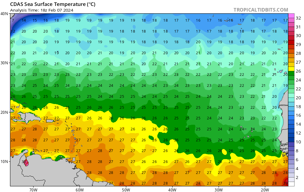
SFLcane wrote:Close up of the wet caribbeam from todays Feb NMME.
https://i.postimg.cc/dtk5sM1k/llll.jpg
Nicaragua got that hurricane shield or something?
0 likes
-
NotSparta

- Professional-Met

- Posts: 1677
- Age: 24
- Joined: Fri Aug 18, 2017 8:24 am
- Location: Naples, FL
- Contact:
Re: 2024 Indicators: SST's, MSLP, Shear, SAL, Steering, Instability, (Day 16+ Climate Models) NMME climate model is up
AutoPenalti wrote:We still have the spring barrier to get through. Very ominous though.
Coming off a strong El Nino, there is no spring barrier. La Nina is on the way, the question is how strong it gets
7 likes
This post was probably an opinion of mine, and in no way is official. Please refer to http://www.hurricanes.gov for official tropical analysis and advisories.
My website, with lots of tropical wx graphics, including satellite and recon: http://cyclonicwx.com
My website, with lots of tropical wx graphics, including satellite and recon: http://cyclonicwx.com
-
cycloneye

- Admin

- Posts: 149261
- Age: 69
- Joined: Thu Oct 10, 2002 10:54 am
- Location: San Juan, Puerto Rico
Re: 2024 Indicators: SST's, MSLP, Shear, SAL, Steering, Instability, (Day 16+ Climate Models) NMME climate model is up
0 likes
Visit the Caribbean-Central America Weather Thread where you can find at first post web cams,radars
and observations from Caribbean basin members Click Here
and observations from Caribbean basin members Click Here
-
SFLcane

- S2K Supporter

- Posts: 10281
- Age: 48
- Joined: Sat Jun 05, 2010 1:44 pm
- Location: Lake Worth Florida
Re: 2024 Indicators: SST's, MSLP, Shear, SAL, Steering, Instability, (Day 16+ Climate Models) NMME climate model is up
When Andy is concerned you know it could get very bad. 3 months to go hope things change!
https://x.com/andyhazelton/status/1755345494941794416
https://x.com/andyhazelton/status/1755345494941794416
1 likes
-
weeniepatrol

- Category 5
- Posts: 1340
- Joined: Sat Aug 22, 2020 5:30 pm
- Location: WA State
Re: 2024 Indicators: SST's, MSLP, Shear, SAL, Steering, Instability, (Day 16+ Climate Models) NMME climate model is up
NotSparta wrote:AutoPenalti wrote:We still have the spring barrier to get through. Very ominous though.
Coming off a strong El Nino, there is no spring barrier. La Nina is on the way, the question is how strong it gets
Yup. User ustropics made a post in the enso thread; 100% of all El Niños of this magnitude (n=10) transitioned to neutral the following season and about half became La Niña. Enso will be at BEST not unfavorable and likely will be favorable.
Last edited by weeniepatrol on Thu Feb 08, 2024 12:27 am, edited 1 time in total.
4 likes
-
NotSparta
- Professional-Met
- Posts: 1677
- Age: 24
- Joined: Fri Aug 18, 2017 8:24 am
- Location: Naples, FL
- Contact:
Re: 2024 Indicators: SST's, MSLP, Shear, SAL, Steering, Instability, (Day 16+ Climate Models) NMME climate model is up
2017 isn't a very good example. February was months before the MDR began to warm
0 likes
This post was probably an opinion of mine, and in no way is official. Please refer to http://www.hurricanes.gov for official tropical analysis and advisories.
My website, with lots of tropical wx graphics, including satellite and recon: http://cyclonicwx.com
My website, with lots of tropical wx graphics, including satellite and recon: http://cyclonicwx.com
-
weeniepatrol
- Category 5
- Posts: 1340
- Joined: Sat Aug 22, 2020 5:30 pm
- Location: WA State
Re: 2024 Indicators: SST's, MSLP, Shear, SAL, Steering, Instability, (Day 16+ Climate Models) NMME climate model is up
(Today vs 4 July 2018)
0 likes
-
weeniepatrol
- Category 5
- Posts: 1340
- Joined: Sat Aug 22, 2020 5:30 pm
- Location: WA State
-
Blown Away

- S2K Supporter
- Posts: 10253
- Joined: Wed May 26, 2004 6:17 am
Re: 2024 Indicators: SST's, MSLP, Shear, SAL, Steering, Instability, (Day 16+ Climate Models) NMME climate model is up
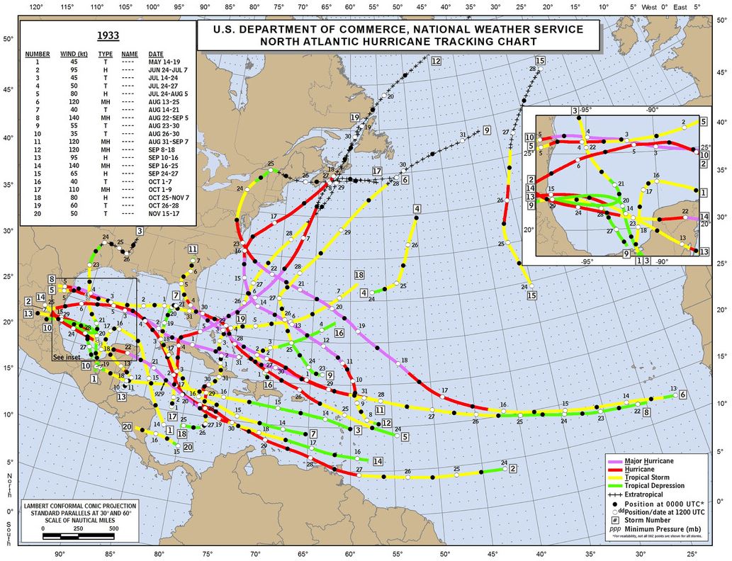
I like 1933 as a comp for 2024 with regards to predicted #'s and tracks... June hurricane in 1933...
1 likes
Hurricane Eye Experience: David 79, Irene 99, Frances 04, Jeanne 04, Wilma 05… Hurricane Brush Experience: Andrew 92, Erin 95, Floyd 99, Matthew 16, Irma 17, Ian 22, Nicole 22…
-
SFLcane
- S2K Supporter
- Posts: 10281
- Age: 48
- Joined: Sat Jun 05, 2010 1:44 pm
- Location: Lake Worth Florida
Re: 2024 Indicators: SST's, MSLP, Shear, SAL, Steering, Instability, (Day 16+ Climate Models) NMME climate model is up
AutoPenalti wrote:We still have the spring barrier to get through. Very ominous though.
As Not Sparta alluded to coming of a strong el nino there isn't much of a spring barrier here the only question is how strong will the developing La Nina be.
Last edited by SFLcane on Thu Feb 08, 2024 11:59 am, edited 1 time in total.
0 likes

Re: 2024 Indicators: SST's, MSLP, Shear, SAL, Steering, Instability, (Day 16+ Climate Models)
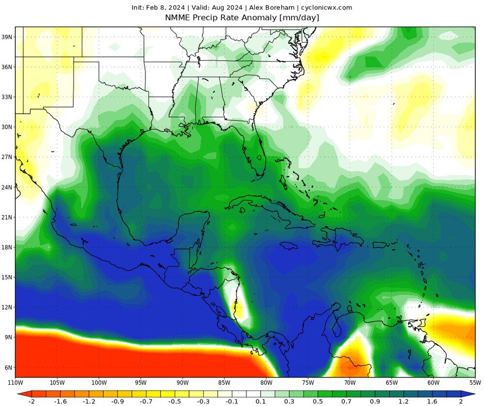
SFLcane wrote:First time phil posts the NMME...
https://x.com/philklotzbach/status/1755614145003782335
From the replies:
https://x.com/catinsight/status/1755620314447229029
https://x.com/dmorris9661/status/1755630897410302264
2 likes
TC naming lists: retirements and intensity
Most aggressive Advisory #1's in North Atlantic (cr. kevin for starting the list)
Most aggressive Advisory #1's in North Atlantic (cr. kevin for starting the list)
-
cycloneye
- Admin
- Posts: 149261
- Age: 69
- Joined: Thu Oct 10, 2002 10:54 am
- Location: San Juan, Puerto Rico
Re: 2024 Indicators: SST's, MSLP, Shear, SAL, Steering, Instability, (Day 16+ Climate Models)
Have a question about La Niña effects.
If La NIña becomes a strong one, would there be more out to sea (Many fish cyclones) or there will be a parade to the Caribbean and CentralAmerica?
If La NIña becomes a strong one, would there be more out to sea (Many fish cyclones) or there will be a parade to the Caribbean and CentralAmerica?
1 likes
Visit the Caribbean-Central America Weather Thread where you can find at first post web cams,radars
and observations from Caribbean basin members Click Here
and observations from Caribbean basin members Click Here

Re: 2024 Indicators: SST's, MSLP, Shear, SAL, Steering, Instability, (Day 16+ Climate Models)
Teban54 wrote:SFLcane wrote:First time phil posts the NMME...
https://x.com/philklotzbach/status/1755614145003782335
From the replies:
https://x.com/catinsight/status/1755620314447229029
https://x.com/dmorris9661/status/1755630897410302264
Seems to me that a 2023 Atlantic steering pattern (weaker/lower W Atlantic 500mb heights = early poleward tracks), would not be what I would anticipate. If for no other reason then taking in consideration the North American Multi-Model Ensemble average outlook calling for the above-normal precipitation across tropical Atlantic at the lower latitudes and all the way across to C. America. I suspect that any broad fanning of storm tracks would occur a good deal further west Caribbean and GOM. That would infer that a 1933 "ish" year would be "Landfall City" (maybe a good year to reconsider that Caribbean or GOM destination wedding for somewhere like Bermuda, Martha's Vineyard or Baja instead?)
Last edited by chaser1 on Thu Feb 08, 2024 1:42 pm, edited 1 time in total.
3 likes
Andy D
(For official information, please refer to the NHC and NWS products.)
(For official information, please refer to the NHC and NWS products.)
Re: 2024 Indicators: SST's, MSLP, Shear, SAL, Steering, Instability, (Day 16+ Climate Models)
cycloneye wrote:Have a question about La Niña effects.
If La NIña becomes a strong one, would there be more out to sea (Many fish cyclones) or there will be a parade to the Caribbean and CentralAmerica?
It's a good question however I don't believe there is any direct ENSO correlation either way. At first blush, I would think "lower" sea-level pressures would generally occur during a LaNina event. I would then extrapolate that lower heights might similarly also be reflected throughout the lower and middle columns of the atmosphere as well? My assumption may be off base but if true, this might lead me to think "lower mid level heights" = weaker Bermuda High = greater number of recurves.
With the majority of long Atlantic tracks tending to recurve during any given year, I would not think that La Nina itself would suggest a tendency for an increased percentage of westward basin tracks. On the other hand, one might speculate that broader basin favorable conditions during La Nina events might allow for both 1) an increase of overall numbers of storms and 2) broader basin wide instability thus increasing risk for cyclogenesis throughout the Atlantic basin. At a minimum it would seem that just this increase in overall enhanced favorability of tropical cyclone development alone would increase the risk & frequency of W. Atlantic basin development and tracks during La Nina years.
2 likes
Andy D
(For official information, please refer to the NHC and NWS products.)
(For official information, please refer to the NHC and NWS products.)
Who is online
Users browsing this forum: mixedDanilo.E and 71 guests