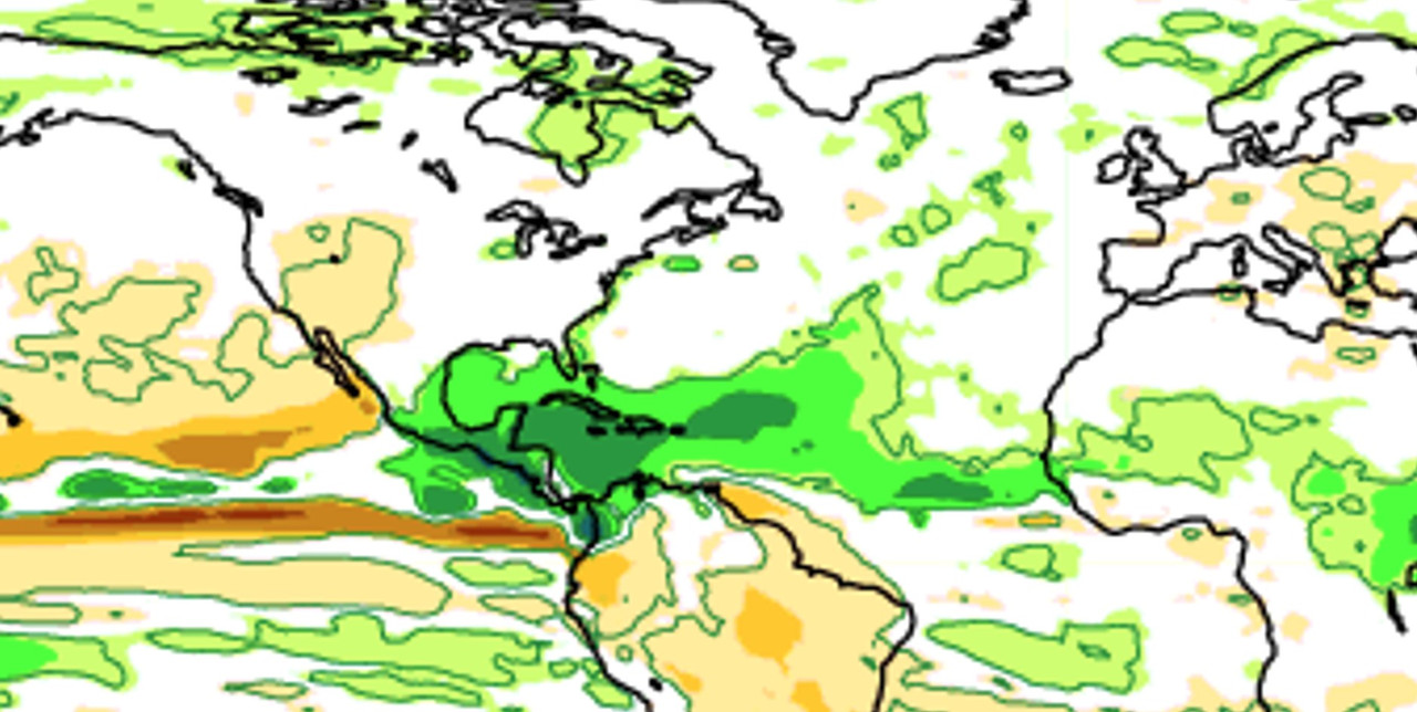
2024 Indicators: SST's, MSLP, Shear, SAL, Steering, Instability (Day 16+ Climate Models)

This is the general tropical discussion area. Anyone can take their shot at predicting a storms path.

Moderator: S2k Moderators

Forum rules

The posts in this forum are NOT official forecasts and should not be used as such. They are just the opinion of the poster and may or may not be backed by sound meteorological data. They are NOT endorsed by any professional institution or STORM2K. For official information, please refer to products from the National Hurricane Center and National Weather Service.

Help Support Storm2K
Message
Author
LarryWx
S2K Supporter
S2K Supporter
Posts: 6305
Joined: Sun Sep 07, 2003 2:04 pm
Location: GA

Re: 2024 Indicators: SST's, MSLP, Shear, SAL, Steering, Instability (Day 16+ Climate Models) June CanSIPS is up

#1141 Postby LarryWx » Sat Jun 01, 2024 2:17 pm

Category5Kaiju wrote:
Cpv17 wrote:With the subtropics warming so much lately, that could possibly mean more recurves, right?


I didn't understand warm subtropics as being indicative of storm tracks? 2017 had relatively warm subtropics and was a heavy landfall year, while last year had a much warmer deep tropics than subtropics and featured very little land impacts.

Generally speaking, ENSO state is an better indication of storm tracks, with El Ninos favoring OTS storms and weak-moderate La Ninas favoring land-impacting tracks. Even then, exact specifics on steering during peak season can't really be determined this far out in time.


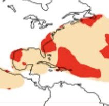
More specifically per TheAustinMan’s great maps, the highest avg landfall anom overall has been favored by weak La Niña followed by moderate to strong Niña (per ASO ONI). In wk Niña, the anom has averaged highest centered over the Bahamas with the area from the N Carib to E GOM to NC well above avg risk. For the CONUS overall, this has been the most dangerous on avg, especially for FL/SE coast and E GOM coast. In mod+ Niña, the avg landfall risk/anom isn’t as high and is centered further SW over the NW Car. The overall Central America risk is slightly higher than that for weak Niña.
With RONI and ONI now so much out of synch, it’s probably better to focus on ASO RONI.
1 likes   
Personal Forecast Disclaimer:
The posts in this forum are NOT official forecasts and should not be used as such. They are just the opinion of the poster and may or may not be backed by sound meteorological data. They are NOT endorsed by any professional institution or storm2k.org. For official information, please refer to the NHC and NWS products.

User avatar
Woofde
Category 1
Category 1
Posts: 479
Joined: Tue Jul 06, 2021 11:33 am

Re: RE: Re: 2024 Indicators: SST's, MSLP, Shear, SAL, Steering, Instability (Day 16+ Climate Models) June CanSIPS is up

#1142 Postby Woofde » Sat Jun 01, 2024 2:30 pm

Category5Kaiju wrote:
Cpv17 wrote:With the subtropics warming so much lately, that could possibly mean more recurves, right?


I didn't understand warm subtropics as being indicative of storm tracks? 2017 had relatively warm subtropics and was a heavy landfall year, while last year had a much warmer deep tropics than subtropics and featured very little land impacts.

Generally speaking, ENSO state is an better indication of storm tracks, with El Ninos favoring OTS storms and weak-moderate La Ninas favoring land-impacting tracks. Even then, exact specifics on steering during peak season can't really be determined this far out in time.
Storms tracks are one of those things that are inherently hard to predict, but agreed ENSO is definitely one of the more concrete areas that has clearer impacts. I posted this graphic in the ENSO channel, but it's important in this context as well. Specifically, the type of ENSO + PDO combo has different effects.

The climate models are all in agreement that we are headed towards a Central Pacific Nina with the -PDO. This combo lends to storms going further west. The other effect is that it usually erodes the Eastern Pacific warmth area that we are seeing now. The NMME and Cansips both agree on this with the CFS being the outlier here holding onto that warmth. It's definitely an aggressive pattern in combination with the Atlantic factors.

The precipitation anomalies support this idea as well, it's why I have my doubts we will have a season similar to 2010. Every season has its wildcards though (*ahem* 2013).ImageImage
5 likes   

User avatar
cycloneye
Admin
Admin
Posts: 145300
Age: 68
Joined: Thu Oct 10, 2002 10:54 am
Location: San Juan, Puerto Rico

Re: RE: Re: 2024 Indicators: SST's, MSLP, Shear, SAL, Steering, Instability (Day 16+ Climate Models) June CanSIPS is up

#1143 Postby cycloneye » Sat Jun 01, 2024 3:56 pm

Woofde wrote:
Category5Kaiju wrote:
Cpv17 wrote:With the subtropics warming so much lately, that could possibly mean more recurves, right?


I didn't understand warm subtropics as being indicative of storm tracks? 2017 had relatively warm subtropics and was a heavy landfall year, while last year had a much warmer deep tropics than subtropics and featured very little land impacts.

Generally speaking, ENSO state is an better indication of storm tracks, with El Ninos favoring OTS storms and weak-moderate La Ninas favoring land-impacting tracks. Even then, exact specifics on steering during peak season can't really be determined this far out in time.
Storms tracks are one of those things that are inherently hard to predict, but agreed ENSO is definitely one of the more concrete areas that has clearer impacts. I posted this graphic in the ENSO channel, but it's important in this context as well. Specifically, the type of ENSO + PDO combo has different effects.

The climate models are all in agreement that we are headed towards a Central Pacific Nina with the -PDO. This combo lends to storms going further west. The other effect is that it usually erodes the Eastern Pacific warmth area that we are seeing now. The NMME and Cansips both agree on this with the CFS being the outlier here holding onto that warmth. It's definitely an aggressive pattern in combination with the Atlantic factors.

The precipitation anomalies support this idea as well, it's why I have my doubts we will have a season similar to 2010. Every season has its wildcards though (*ahem* 2013).https://uploads.tapatalk-cdn.com/20240601/a2db39801ea6fe5d24e2cfa10e21bd4e.jpg https://uploads.tapatalk-cdn.com/20240601/b12d6e14668c7c2b04db93c3589ebf62.jpg


Those very warm anomalies in the Caribbean is what draws my atention.
1 likes   
Visit the Caribbean-Central America Weather Thread where you can find at first post web cams,radars
and observations from Caribbean basin members Click Here

User avatar
Woofde
Category 1
Category 1
Posts: 479
Joined: Tue Jul 06, 2021 11:33 am

Re: RE: Re: RE: Re: 2024 Indicators: SST's, MSLP, Shear, SAL, Steering, Instability (Day 16+ Climate Models) June CanSIP

#1144 Postby Woofde » Sat Jun 01, 2024 5:43 pm

cycloneye wrote:
Woofde wrote:
Category5Kaiju wrote:
I didn't understand warm subtropics as being indicative of storm tracks? 2017 had relatively warm subtropics and was a heavy landfall year, while last year had a much warmer deep tropics than subtropics and featured very little land impacts.

Generally speaking, ENSO state is an better indication of storm tracks, with El Ninos favoring OTS storms and weak-moderate La Ninas favoring land-impacting tracks. Even then, exact specifics on steering during peak season can't really be determined this far out in time.
Storms tracks are one of those things that are inherently hard to predict, but agreed ENSO is definitely one of the more concrete areas that has clearer impacts. I posted this graphic in the ENSO channel, but it's important in this context as well. Specifically, the type of ENSO + PDO combo has different effects.

The climate models are all in agreement that we are headed towards a Central Pacific Nina with the -PDO. This combo lends to storms going further west. The other effect is that it usually erodes the Eastern Pacific warmth area that we are seeing now. The NMME and Cansips both agree on this with the CFS being the outlier here holding onto that warmth. It's definitely an aggressive pattern in combination with the Atlantic factors.

The precipitation anomalies support this idea as well, it's why I have my doubts we will have a season similar to 2010. Every season has its wildcards though (*ahem* 2013).https://uploads.tapatalk-cdn.com/20240601/a2db39801ea6fe5d24e2cfa10e21bd4e.jpg https://uploads.tapatalk-cdn.com/20240601/b12d6e14668c7c2b04db93c3589ebf62.jpg


Those very warm anomalies in the Caribbean is what draws my atention.
Yeah, I would not be surprised to see some 2020-esque late season with that much warmth and a la nina.
3 likes   

Deshaunrob17
Tropical Storm
Tropical Storm
Posts: 207
Joined: Tue Aug 18, 2020 7:49 am

Re: 2024 Indicators: SST's, MSLP, Shear, SAL, Steering, Instability (Day 16+ Climate Models)

#1145 Postby Deshaunrob17 » Sun Jun 02, 2024 6:35 am

[*] GFS has an impressive wave running into Trinidad and Tobago next weekend with some vorticity. That area has to be watched in June because we have seen an increase in activity there the last few years in June- Bret (2017), Elsa( 2021) and other failed attempts at genesis. It makes sense to me since the wave train is still at a low lattitude in June. Also, I don’t know how much more favorable 1933 was, but I find the Trinidad hurricane of that year to be interesting. Could conditions be as favorable this year for something similar to happen?

Again, when conditions are more favorable than normal in June , that puts the Southern Caribbean at risk since the wave train is at a low lattitude in June.
1 likes   

User avatar
Category5Kaiju
Category 5
Category 5
Posts: 4096
Joined: Thu Dec 24, 2020 12:45 pm
Location: Seattle

Re: 2024 Indicators: SST's, MSLP, Shear, SAL, Steering, Instability (Day 16+ Climate Models)

#1146 Postby Category5Kaiju » Sun Jun 02, 2024 9:30 am

Deshaunrob17 wrote:[*] GFS has an impressive wave running into Trinidad and Tobago next weekend with some vorticity. That area has to be watched in June because we have seen an increase in activity there the last few years in June- Bret (2017), Elsa( 2021) and other failed attempts at genesis. It makes sense to me since the wave train is still at a low lattitude in June. Also, I don’t know how much more favorable 1933 was, but I find the Trinidad hurricane of that year to be interesting. Could conditions be as favorable this year for something similar to happen?

Again, when conditions are more favorable than normal in June , that puts the Southern Caribbean at risk since the wave train is at a low lattitude in June.


That's what I've been kind of wondering too. It's quite rare to see borderline major or bona fide major hurricanes in June and July, especially ones that threaten land (to the point they become retirable) and especially ones at the levels of Dennis or Emily. However, it's certainly happened before in multiple years dating back to 1900.

While it's generally not a good idea to predict that a given year will see such a kind of anomalous system, given how favorable things seem to be setting up for this year's hurricane season and given how it's been a while since we saw this kind of storm, one has to wonder if this might be something we see anytime soon. And of all the years where this could happen, this year seems like a good contender (it really helps that 1933, 2005, and 2010 are being compared with this year quite frequently, and all three of those years saw powerful June or July hurricanes that threatened land). Personally, I think it's bound to happen again at some point, but that's just me.
0 likes   
Unless explicitly stated, all info in my posts is based on my own opinions and observations. Tropical storms and hurricanes can be extremely dangerous. Do not think you can beat Mother Nature. Refer to an accredited weather research agency or meteorologist if you need to make serious decisions regarding an approaching storm.

User avatar
StPeteMike
Category 2
Category 2
Posts: 631
Joined: Thu Jun 07, 2018 11:26 pm

Re: 2024 Indicators: SST's, MSLP, Shear, SAL, Steering, Instability (Day 16+ Climate Models)

#1147 Postby StPeteMike » Sun Jun 02, 2024 10:43 pm

Would anyone have an explanation for the very sudden cooler SST anomalies in the near Pacific Ocean and Bering Sea in the last couple weeks? Could that have any impacts on La Niña and do we have any years that something similar has happened like this?
0 likes   
The above post is not official and should not be used as such. It is the opinion of the poster and may or may not be backed by sound meteorological data. It is not endorsed by any professional institution or storm2k.org. For official information, please refer to the NHC and NWS products.

User avatar
NotSparta
Professional-Met
Professional-Met
Posts: 1668
Age: 23
Joined: Fri Aug 18, 2017 8:24 am
Location: Naples, FL
Contact:

Re: 2024 Indicators: SST's, MSLP, Shear, SAL, Steering, Instability (Day 16+ Climate Models)

#1148 Postby NotSparta » Mon Jun 03, 2024 5:07 am

StPeteMike wrote:Would anyone have an explanation for the very sudden cooler SST anomalies in the near Pacific Ocean and Bering Sea in the last couple weeks? Could that have any impacts on La Niña and do we have any years that something similar has happened like this?


-PDO is reasserting itself, in line with La Niña on the way.
5 likes   
This post was probably an opinion of mine, and in no way is official. Please refer to http://www.hurricanes.gov for official tropical analysis and advisories.

My website, with lots of tropical wx graphics, including satellite and recon: http://cyclonicwx.com

User avatar
Blown Away
S2K Supporter
S2K Supporter
Posts: 10145
Joined: Wed May 26, 2004 6:17 am

Re: RE: Re: 2024 Indicators: SST's, MSLP, Shear, SAL, Steering, Instability (Day 16+ Climate Models) June CanSIPS is up

#1149 Postby Blown Away » Mon Jun 03, 2024 6:37 am

Woofde wrote:
Category5Kaiju wrote:
Cpv17 wrote:With the subtropics warming so much lately, that could possibly mean more recurves, right?


I didn't understand warm subtropics as being indicative of storm tracks? 2017 had relatively warm subtropics and was a heavy landfall year, while last year had a much warmer deep tropics than subtropics and featured very little land impacts.

Generally speaking, ENSO state is an better indication of storm tracks, with El Ninos favoring OTS storms and weak-moderate La Ninas favoring land-impacting tracks. Even then, exact specifics on steering during peak season can't really be determined this far out in time.
Storms tracks are one of those things that are inherently hard to predict, but agreed ENSO is definitely one of the more concrete areas that has clearer impacts. I posted this graphic in the ENSO channel, but it's important in this context as well. Specifically, the type of ENSO + PDO combo has different effects.

The climate models are all in agreement that we are headed towards a Central Pacific Nina with the -PDO. This combo lends to storms going further west. The other effect is that it usually erodes the Eastern Pacific warmth area that we are seeing now. The NMME and Cansips both agree on this with the CFS being the outlier here holding onto that warmth. It's definitely an aggressive pattern in combination with the Atlantic factors.

The precipitation anomalies support this idea as well, it's why I have my doubts we will have a season similar to 2010. Every season has its wildcards though (*ahem* 2013).https://uploads.tapatalk-cdn.com/20240601/a2db39801ea6fe5d24e2cfa10e21bd4e.jpg https://uploads.tapatalk-cdn.com/20240601/b12d6e14668c7c2b04db93c3589ebf62.jpg


Nice summary! Do you have Cansips SST summary for 2010 & 2020 to see if they were Central or Eastern pacific Nina's?
0 likes   
Hurricane Eye Experience: David 79, Irene 99, Frances 04, Jeanne 04, Wilma 05... EYE COMING MY WAY IN 2024…
Hurricane Brush Experience: Andrew 92, Erin 95, Floyd 99, Matthew 16, Irma 17, Ian 22, Nicole 22…

LarryWx
S2K Supporter
S2K Supporter
Posts: 6305
Joined: Sun Sep 07, 2003 2:04 pm
Location: GA

Re: RE: Re: 2024 Indicators: SST's, MSLP, Shear, SAL, Steering, Instability (Day 16+ Climate Models) June CanSIPS is up

#1150 Postby LarryWx » Mon Jun 03, 2024 7:53 am

Blown Away wrote:
Woofde wrote:
Category5Kaiju wrote:
I didn't understand warm subtropics as being indicative of storm tracks? 2017 had relatively warm subtropics and was a heavy landfall year, while last year had a much warmer deep tropics than subtropics and featured very little land impacts.

Generally speaking, ENSO state is an better indication of storm tracks, with El Ninos favoring OTS storms and weak-moderate La Ninas favoring land-impacting tracks. Even then, exact specifics on steering during peak season can't really be determined this far out in time.
Storms tracks are one of those things that are inherently hard to predict, but agreed ENSO is definitely one of the more concrete areas that has clearer impacts. I posted this graphic in the ENSO channel, but it's important in this context as well. Specifically, the type of ENSO + PDO combo has different effects.

The climate models are all in agreement that we are headed towards a Central Pacific Nina with the -PDO. This combo lends to storms going further west. The other effect is that it usually erodes the Eastern Pacific warmth area that we are seeing now. The NMME and Cansips both agree on this with the CFS being the outlier here holding onto that warmth. It's definitely an aggressive pattern in combination with the Atlantic factors.

The precipitation anomalies support this idea as well, it's why I have my doubts we will have a season similar to 2010. Every season has its wildcards though (*ahem* 2013).https://uploads.tapatalk-cdn.com/20240601/a2db39801ea6fe5d24e2cfa10e21bd4e.jpg https://uploads.tapatalk-cdn.com/20240601/b12d6e14668c7c2b04db93c3589ebf62.jpg


Nice summary! Do you have Cansips SST summary for 2010 & 2020 to see if they were Central or Eastern pacific Nina's?


Per NOAA weeklies, week centered on late May for regions 1+2, 3, 3.4, 4 (i.e., moving from east to west): keep in mind these don’t take into account surrounding water in a relative way like RONI does for 3.4, but these are still a good indication of where the coolest/least cool anomalies are:

5/29/2024: -1.1, -0.3, +0.1, +0.7
5/27/2020: -0.9, -0.5, -0.4, +0.1
5/26/2010: -0.2, -0.4, -0.2, +0.1

So, as of late May 2024 is E based like 2020 but with ~twice the gradient from E to W. In contrast, 2010 was pretty flat.

Now as we look ahead toward mid Sept, 2024 is expected to become less E based/flatter and significantly cooler in 3.4.

How were 2020 and 2010?

9/16/2020: -0.6, -0.8, -0.6, -0.4 (pretty flat/weak)
9/15/2010: -1.2, -1.0, -1.3, -1.6 (pretty flat but little more W based/moderate)

https://www.cpc.ncep.noaa.gov/data/indi ... st9120.for
2 likes   
Personal Forecast Disclaimer:
The posts in this forum are NOT official forecasts and should not be used as such. They are just the opinion of the poster and may or may not be backed by sound meteorological data. They are NOT endorsed by any professional institution or storm2k.org. For official information, please refer to the NHC and NWS products.

User avatar
cycloneye
Admin
Admin
Posts: 145300
Age: 68
Joined: Thu Oct 10, 2002 10:54 am
Location: San Juan, Puerto Rico

Re: 2024 Indicators: SST's, MSLP, Shear, SAL, Steering, Instability (Day 16+ Climate Models)

#1151 Postby cycloneye » Mon Jun 03, 2024 12:32 pm

0 likes   
Visit the Caribbean-Central America Weather Thread where you can find at first post web cams,radars
and observations from Caribbean basin members Click Here

User avatar
cycloneye
Admin
Admin
Posts: 145300
Age: 68
Joined: Thu Oct 10, 2002 10:54 am
Location: San Juan, Puerto Rico

Re: 2024 Indicators: SST's, MSLP, Shear, SAL, Steering, Instability (Day 16+ Climate Models)

#1152 Postby cycloneye » Mon Jun 03, 2024 8:00 pm

0 likes   
Visit the Caribbean-Central America Weather Thread where you can find at first post web cams,radars
and observations from Caribbean basin members Click Here

User avatar
wxman57
Moderator-Pro Met
Moderator-Pro Met
Posts: 22978
Age: 67
Joined: Sat Jun 21, 2003 8:06 pm
Location: Houston, TX (southwest)

Re: 2024 Indicators: SST's, MSLP, Shear, SAL, Steering, Instability (Day 16+ Climate Models) ECMWF is up

#1153 Postby wxman57 » Wed Jun 05, 2024 8:27 am

June ECMWF seasonal forecast is in. Between July 1 and Dec 31, it is now predicting 21.1 NS, down from 22.8 in May. For hurricanes, 11.3, down from 12.8 in May. ACE still 200% of normal. I expected a decrease in NS over May, since June is no longer considered. However, I think the fewer hurricanes is significant, indicating that it's a bit less bullish on activity this season. Also, the track density has less Caribbean and Gulf activity.
1 likes   

User avatar
cycloneye
Admin
Admin
Posts: 145300
Age: 68
Joined: Thu Oct 10, 2002 10:54 am
Location: San Juan, Puerto Rico

Re: 2024 Indicators: SST's, MSLP, Shear, SAL, Steering, Instability (Day 16+ Climate Models) ECMWF is up

#1154 Postby cycloneye » Wed Jun 05, 2024 8:31 am

Less ridging in this new ECMWF run meaning more OTS tracks.

Image
0 likes   
Visit the Caribbean-Central America Weather Thread where you can find at first post web cams,radars
and observations from Caribbean basin members Click Here

User avatar
cycloneye
Admin
Admin
Posts: 145300
Age: 68
Joined: Thu Oct 10, 2002 10:54 am
Location: San Juan, Puerto Rico

Re: 2024 Indicators: SST's, MSLP, Shear, SAL, Steering, Instability (Day 16+ Climate Models) ECMWF is up

#1155 Postby cycloneye » Wed Jun 05, 2024 8:33 am

wxman57 wrote:June ECMWF seasonal forecast is in. Between July 1 and Dec 31, it is now predicting 21.1 NS, down from 22.8 in May. For hurricanes, 11.3, down from 12.8 in May. ACE still 200% of normal. I expected a decrease in NS over May, since June is no longer considered. However, I think the fewer hurricanes is significant, indicating that it's a bit less bullish on activity this season. Also, the track density has less Caribbean and Gulf activity.


More quality than quantity.
0 likes   
Visit the Caribbean-Central America Weather Thread where you can find at first post web cams,radars
and observations from Caribbean basin members Click Here

User avatar
SFLcane
S2K Supporter
S2K Supporter
Posts: 10163
Age: 47
Joined: Sat Jun 05, 2010 1:44 pm
Location: Lake Worth Florida

Re: 2024 Indicators: SST's, MSLP, Shear, SAL, Steering, Instability (Day 16+ Climate Models) ECMWF is up

#1156 Postby SFLcane » Wed Jun 05, 2024 8:51 am

wxman57 wrote:June ECMWF seasonal forecast is in. Between July 1 and Dec 31, it is now predicting 21.1 NS, down from 22.8 in May. For hurricanes, 11.3, down from 12.8 in May. ACE still 200% of normal. I expected a decrease in NS over May, since June is no longer considered. However, I think the fewer hurricanes is significant, indicating that it's a bit less bullish on activity this season. Also, the track density has less Caribbean and Gulf activity.


Caribbean looks very active in my opinion actually. Hotspot could be SW atlantic this yr. Most will recurve as they do every yr but a few could make it through.

Image

Image
0 likes   

User avatar
skyline385
Category 5
Category 5
Posts: 2728
Age: 35
Joined: Wed Aug 26, 2020 11:15 pm
Location: Houston TX

Re: 2024 Indicators: SST's, MSLP, Shear, SAL, Steering, Instability (Day 16+ Climate Models)

#1157 Postby skyline385 » Wed Jun 05, 2024 8:56 am

skyline385 wrote:Current CFS trend moving towards some recurves with few managing to get into the GoM in August which is very believable and also matches with the C3S 500mb from last month although the CFS might have a stronger ridge over the US compared to the C3S.

Image

Image


Interesting that the SEAS5 also showed the same eastwards shift as the CFS with slightly weaker ridging. Not that I would ever put much faith into TS paths on seasonal models this far out but they do seem to be hinting that the ridging might not be as strong as previously thought.

Image

Image
0 likes   

User avatar
wxman57
Moderator-Pro Met
Moderator-Pro Met
Posts: 22978
Age: 67
Joined: Sat Jun 21, 2003 8:06 pm
Location: Houston, TX (southwest)

Re: 2024 Indicators: SST's, MSLP, Shear, SAL, Steering, Instability (Day 16+ Climate Models) ECMWF is up

#1158 Postby wxman57 » Wed Jun 05, 2024 9:37 am

SFLcane wrote:
wxman57 wrote:June ECMWF seasonal forecast is in. Between July 1 and Dec 31, it is now predicting 21.1 NS, down from 22.8 in May. For hurricanes, 11.3, down from 12.8 in May. ACE still 200% of normal. I expected a decrease in NS over May, since June is no longer considered. However, I think the fewer hurricanes is significant, indicating that it's a bit less bullish on activity this season. Also, the track density has less Caribbean and Gulf activity.


Caribbean looks very active in my opinion actually. Hotspot could be SW atlantic this yr. Most will recurve as they do every yr but a few could make it through.

https://i.postimg.cc/ydc3w5bs/hhhhhm.jpg

https://i.postimg.cc/HW07zqMt/hkhkh.jpg


As for the Caribbean, I only noted the decrease (removal) of any red track density from the Caribbean in the June forecast. Everything indicates less dry, sinking air there this year. However, I'm beginning to think that predicted numbers will be going down over the next month or so.
0 likes   

User avatar
ScottNAtlanta
Category 5
Category 5
Posts: 2367
Joined: Sat May 25, 2013 3:11 pm
Location: Atlanta, GA

Re: 2024 Indicators: SST's, MSLP, Shear, SAL, Steering, Instability (Day 16+ Climate Models) ECMWF is up

#1159 Postby ScottNAtlanta » Wed Jun 05, 2024 9:51 am

Just as a friendly reminder...just because the models for a 3 month period show "less" ridging doesn't mean that it wont fluctuate between more and less. This is just an average. If a hurricane is headed west with strong ridging to the north, the fact that in 2 weeks there isn't as much wont matter for for anyone impacted by first scenario. Like they say...it only takes one big hit where you live to be a busy season just like a week or two of strong ridging with less on each side can be a deciding factor for that one storm.
2 likes   
The posts in this forum are NOT official forecast and should not be used as such. They are just the opinion of the poster and may or may not be backed by sound meteorological data. They are NOT endorsed by any professional institution or storm2k.org. For official information, please refer to the NHC and NWS products.

User avatar
Category5Kaiju
Category 5
Category 5
Posts: 4096
Joined: Thu Dec 24, 2020 12:45 pm
Location: Seattle

Re: 2024 Indicators: SST's, MSLP, Shear, SAL, Steering, Instability (Day 16+ Climate Models) ECMWF is up

#1160 Postby Category5Kaiju » Wed Jun 05, 2024 10:13 am

You know, with all this talk of “oh there’s going to be more ridging” or “oh there’s going to be less ridging,” I wonder how these models would have forecasted the actual huge landfall years at this point in time. Noteworthy examples being 1998, 2004, 2005, and 2017. Feel like we need some baseline comparisons for things to be a bit more clear. Just my two cents though.
1 likes   
Unless explicitly stated, all info in my posts is based on my own opinions and observations. Tropical storms and hurricanes can be extremely dangerous. Do not think you can beat Mother Nature. Refer to an accredited weather research agency or meteorologist if you need to make serious decisions regarding an approaching storm.


Return to “Talkin' Tropics”

Who is online

Users browsing this forum: Ulf and 18 guests