Tropical Wave SW of the Cabo Verde Islands (Is Invest 96L)
Moderator: S2k Moderators
Forum rules

The posts in this forum are NOT official forecasts and should not be used as such. They are just the opinion of the poster and may or may not be backed by sound meteorological data. They are NOT endorsed by any professional institution or STORM2K. For official information, please refer to products from the National Hurricane Center and National Weather Service.
Re: Tropical Wave SSW of the Cabo Verde Islands (0/40)
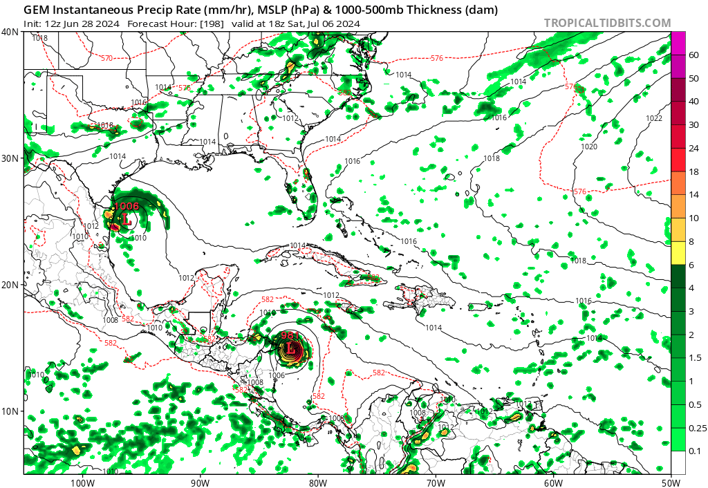
00Z CMC takes this to the FL panhandle in 10 days.
0 likes

Re: Tropical Wave SSW of the Cabo Verde Islands (0/40)
IcyTundra wrote:00Z CMC takes this to the FL panhandle in 10 days.
I think we all need to pay attention to this one. Absolutely wild for late June.
3 likes
-
cycloneye

- Admin

- Posts: 149125
- Age: 69
- Joined: Thu Oct 10, 2002 10:54 am
- Location: San Juan, Puerto Rico
Re: Tropical Wave SSW of the Cabo Verde Islands (10/50)
Eastern Tropical Atlantic:
A tropical wave located several hundred miles south-southwest of the
Cabo Verde Islands is producing an area of disorganized showers and
thunderstorms. Environmental conditions appear conducive for
additional development of this system, and a tropical depression
could form by the middle of next week while it moves generally
westward at 15 to 20 mph across the eastern and central tropical
Atlantic.
* Formation chance through 48 hours...low...10 percent.
* Formation chance through 7 days...medium...50 percent.
0 likes
Visit the Caribbean-Central America Weather Thread where you can find at first post web cams,radars
and observations from Caribbean basin members Click Here
and observations from Caribbean basin members Click Here
-
jlauderdal
- S2K Supporter

- Posts: 7240
- Joined: Wed May 19, 2004 5:46 am
- Location: NE Fort Lauderdale
- Contact:
Re: Tropical Wave SSW of the Cabo Verde Islands (10/50)
cycloneye wrote:Eastern Tropical Atlantic:
A tropical wave located several hundred miles south-southwest of the
Cabo Verde Islands is producing an area of disorganized showers and
thunderstorms. Environmental conditions appear conducive for
additional development of this system, and a tropical depression
could form by the middle of next week while it moves generally
westward at 15 to 20 mph across the eastern and central tropical
Atlantic.
* Formation chance through 48 hours...low...10 percent.
* Formation chance through 7 days...medium...50 percent.
GFS and Euro have similar paths for this storm as they do for Beryl; both storms in dangerous positions with real potential.
1 likes

Re: Tropical Wave SSW of the Cabo Verde Islands (10/50)
It's the CMC, but yeah, the model for this wave just flipped from Honduras to FL Panhandle in a single run 
1 likes
TC naming lists: retirements and intensity
Most aggressive Advisory #1's in North Atlantic (cr. kevin for starting the list)
Most aggressive Advisory #1's in North Atlantic (cr. kevin for starting the list)
-
cycloneye
- Admin
- Posts: 149125
- Age: 69
- Joined: Thu Oct 10, 2002 10:54 am
- Location: San Juan, Puerto Rico
Re: Tropical Wave SSW of the Cabo Verde Islands (20/60)
Eastern Tropical Atlantic:
An area of low pressure located several hundred miles southwest of
the Cabo Verde Islands is producing an area of disorganized showers
and thunderstorms. Environmental conditions appear conducive for
additional development of this system, and a tropical depression
could form by the middle of next week while it moves generally
westward at 15 to 20 mph across the eastern and central tropical
Atlantic.
* Formation chance through 48 hours...low...20 percent.
* Formation chance through 7 days...medium...60 percent.
0 likes
Visit the Caribbean-Central America Weather Thread where you can find at first post web cams,radars
and observations from Caribbean basin members Click Here
and observations from Caribbean basin members Click Here
Re: Tropical Wave SSW of the Cabo Verde Islands (20/60)

Definitely keep an eye on this system
2 likes
Re: Tropical Wave SSW of the Cabo Verde Islands (20/60)
zzzh wrote:https://i.imgur.com/uJhIszV.png
Definitely keep an eye on this system
I would think they would have this as 96L.
0 likes
Personal Forecast Disclaimer:
The posts in this forum are NOT official forecast and should not be used as such. They are just the opinion of the poster and may or may not be backed by sound meteorological data. They are NOT endorsed by any professional institution or storm2k.org. For official information, please refer to the NHC and NWS products.
The posts in this forum are NOT official forecast and should not be used as such. They are just the opinion of the poster and may or may not be backed by sound meteorological data. They are NOT endorsed by any professional institution or storm2k.org. For official information, please refer to the NHC and NWS products.
-
cycloneye
- Admin
- Posts: 149125
- Age: 69
- Joined: Thu Oct 10, 2002 10:54 am
- Location: San Juan, Puerto Rico
Re: Tropical Wave SSW of the Cabo Verde Islands (20/60)
Blinhart wrote:zzzh wrote:https://i.imgur.com/uJhIszV.png
Definitely keep an eye on this system
I would think they would have this as 96L.
Invest is comming up very soon.
1 likes
Visit the Caribbean-Central America Weather Thread where you can find at first post web cams,radars
and observations from Caribbean basin members Click Here
and observations from Caribbean basin members Click Here
-
cycloneye
- Admin
- Posts: 149125
- Age: 69
- Joined: Thu Oct 10, 2002 10:54 am
- Location: San Juan, Puerto Rico
Re: Tropical Wave SSW of the Cabo Verde Islands (20/60)
Look how well is turning already.

0 likes
Visit the Caribbean-Central America Weather Thread where you can find at first post web cams,radars
and observations from Caribbean basin members Click Here
and observations from Caribbean basin members Click Here
-
Blown Away

- S2K Supporter
- Posts: 10253
- Joined: Wed May 26, 2004 6:17 am
Re: Tropical Wave SSW of the Cabo Verde Islands (20/60)
Come on NHC, 20/60 and no Invest 96???

1 likes
Hurricane Eye Experience: David 79, Irene 99, Frances 04, Jeanne 04, Wilma 05… Hurricane Brush Experience: Andrew 92, Erin 95, Floyd 99, Matthew 16, Irma 17, Ian 22, Nicole 22…

Re: Tropical Wave SW of the Cabo Verde Islands (20/60)
Fascinating how ASCAT nearly closes off a LLC as far south as 6.5N latitude..... in June no less Crazy times. Looking at satellite however, it appears that the broader mid-level low extends well NNE from that point, and I'd guess that by the time that this develops, a COC will likely be pulled up a tad to about 9N as any current LLC eventually gets pulled up around the right side of the broader MLC in about 48-72 hours.
0 likes
Andy D
(For official information, please refer to the NHC and NWS products.)
(For official information, please refer to the NHC and NWS products.)


Re: Tropical Wave SW of the Cabo Verde Islands (20/60)
Really surprised this hasn't been tagged yet. I bet invest 96L and 30/70 is coming later today.
1 likes
Re: Tropical Wave SW of the Cabo Verde Islands (20/60)
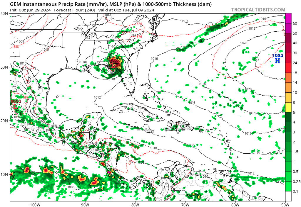
Long range model spread on this one is pretty large, I don't think it follows exactly like Beryl . GFS is turning into into the shredder islands. Canadian has it in for Houston.
0 likes
-
cycloneye
- Admin
- Posts: 149125
- Age: 69
- Joined: Thu Oct 10, 2002 10:54 am
- Location: San Juan, Puerto Rico
Re: Tropical Wave SW of the Cabo Verde Islands (30/70)
Eastern Tropical Atlantic:
An area of low pressure located several hundred miles southwest of
the Cabo Verde Islands is producing an area of disorganized showers
and thunderstorms. Environmental conditions appear conducive for
additional development of this system, and a tropical depression
could form by the middle of next week while it moves generally
westward at 15 to 20 mph across the eastern and central tropical
Atlantic.
* Formation chance through 48 hours...low...30 percent.
* Formation chance through 7 days...high...70 percent.
0 likes
Visit the Caribbean-Central America Weather Thread where you can find at first post web cams,radars
and observations from Caribbean basin members Click Here
and observations from Caribbean basin members Click Here
Re: Tropical Wave SW of the Cabo Verde Islands (20/60)
Models are been aggressive on this one as well as Beryl.
HWRF model run of Beryl, this wave is the system on the far right of the run.

HWRF model run of Beryl, this wave is the system on the far right of the run.
Last edited by ChrisH-UK on Sat Jun 29, 2024 1:58 pm, edited 1 time in total.
0 likes
-
BIFF_THE_UNRULY
- Tropical Storm

- Posts: 143
- Joined: Fri Jun 28, 2024 2:12 pm
Re: Tropical Wave SW of the Cabo Verde Islands (20/60)
ChrisH-UK wrote:Models are been aggressive on this one as well as Beryl.
HWRF model run
[url]https://imagizer.imageshack.com/img923/4536/cnA2ry.gif [/url]
Another one behind it.
This is an active june. Not ass active as 2005 but dang. We better keep our eyes on the tropics
It has 48 hours to bmform 2 storms and equal 2005
0 likes

Re: Tropical Wave SW of the Cabo Verde Islands (30/70)
Pure madness! Reminds me of 2005, hopefully won't remind us of that July with the intensities too...
For now the tracks are similar to the duo of Dennis & Emily.
For now the tracks are similar to the duo of Dennis & Emily.
1 likes
Georges '98, Irene '99, Frances '04, Jeanne '04, Katrina '05, Wilma '05, Gustav '08, Isaac '12, Matthew '16, Florence '18, Michael '18, Ian '22
-
Emmett_Brown

- Category 5

- Posts: 1433
- Joined: Wed Aug 24, 2005 9:10 pm
- Location: Sarasota FL
Re: Tropical Wave SW of the Cabo Verde Islands (30/70)
12Z Euro keeps it as a wave or very weak low through the Caribbean.
0 likes
Re: Tropical Wave SW of the Cabo Verde Islands (20/60)
BIFF_THE_UNRULY wrote:ChrisH-UK wrote:Models are been aggressive on this one as well as Beryl.
HWRF model run
[url]https://imagizer.imageshack.com/img923/4536/cnA2ry.gif [/url]
Another one behind it.
This is an active june. Not ass active as 2005 but dang. We better keep our eyes on the tropics
It has 48 hours to bmform 2 storms and equal 2005
Opps in my haste this is the Beryl run, this wave is the one on the right,
0 likes
Who is online
Users browsing this forum: No registered users and 67 guests