ATL: BERYL - Models
Moderator: S2k Moderators

Re: ATL: BERYL - Models
Given Beryl is now a hurricane, and the latest euro run, it’s becoming more clear that the GFS has had more merit than the euro with Beryl over the last few days.
5 likes
Igor 2010, Sandy 2012, Fay 2014, Gonzalo 2014, Joaquin 2015, Nicole 2016, Humberto 2019, Imelda 2025
I am only a tropical weather enthusiast. My predictions are not official and may or may not be backed by sound meteorological data. For official information, please refer to the NHC and NWS products.
I am only a tropical weather enthusiast. My predictions are not official and may or may not be backed by sound meteorological data. For official information, please refer to the NHC and NWS products.
-
DorkyMcDorkface

- Category 5

- Posts: 1042
- Age: 28
- Joined: Mon Sep 30, 2019 1:32 pm
- Location: Mid-Atlantic
Re: ATL: BERYL - Models
Not saying this will bomb out to 140kt like the 12z HWRF has buuuuuut...
9 likes
Please note the thoughts expressed by this account are solely those of the user and are from a hobbyist perspective. For more comprehensive analysis, consult an actual professional meteorologist or meteorological agency.
Floyd 1999 | Isabel 2003 | Hanna 2008 | Irene 2011 | Sandy 2012 | Isaias 2020
-
HurricaneBrain

- S2K Supporter

- Posts: 520
- Joined: Thu Jun 30, 2011 2:07 pm
Re: ATL: BERYL - Models
Yep - stronger system will move more poleward.
lsuhurricane wrote:https://i.ibb.co/Wp1nSV2/14-km-EPS-Global-Cyclones-Caribbean-Ens-MSLP-Spaghettios.gif
Presented without comment
0 likes

Re: ATL: BERYL - Models
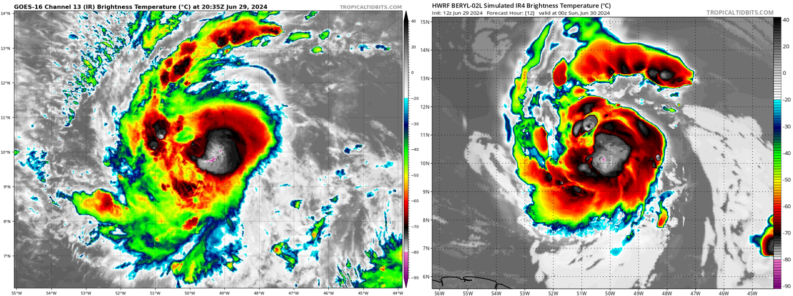
DorkyMcDorkface wrote:Not saying this will bomb out to 140kt like the 12z HWRF has buuuuuut...
https://uploads.disquscdn.com/images/bd3df900866214fcc7269d763e338ba667c200d81f7f55554ec8db4a7a1b3e66.png
Everyone likes to rag on the HWRF for going overkill with intensity estimates, but this is another great example (along with Dorian on 8/31/19) of how well it can do with predicting short-term structural evolution.
3 likes
Irene '11 Sandy '12 Hermine '16 5/15/2018 Derecho Fay '20 Isaias '20 Elsa '21 Henri '21 Ida '21
I am only a meteorology enthusiast who knows a decent amount about tropical cyclones. Look to the professional mets, the NHC, or your local weather office for the best information.
I am only a meteorology enthusiast who knows a decent amount about tropical cyclones. Look to the professional mets, the NHC, or your local weather office for the best information.
-
Category5Kaiju

- Category 5
- Posts: 4345
- Joined: Thu Dec 24, 2020 12:45 pm
- Location: Seattle during the summer, Phoenix during the winter
Re: ATL: BERYL - Models
aspen wrote:DorkyMcDorkface wrote:Not saying this will bomb out to 140kt like the 12z HWRF has buuuuuut...
https://uploads.disquscdn.com/images/bd3df900866214fcc7269d763e338ba667c200d81f7f55554ec8db4a7a1b3e66.png
Everyone likes to rag on the HWRF for going overkill with intensity estimates, but this is another great example (along with Dorian on 8/31/19) of how well it can do with predicting short-term structural evolution.
HWRF, imho, usually shows near-worst or worst case scenarios that a certain storm could exhibit. Many of the times, it's pretty off the rails. But there are definitely a select few times when it hits the jackpot.
1 likes
Unless explicitly stated, all information in my posts is based on my own opinions and observations. Tropical storms and hurricanes can be extremely dangerous. Refer to an accredited weather research agency or meteorologist if you need to make serious decisions regarding an approaching storm.
-
StormPyrate
- Category 1

- Posts: 286
- Joined: Sun May 27, 2018 8:41 pm
- Location: Clearwater, FL
Re: ATL: BERYL - Models
lsuhurricane wrote:https://i.ibb.co/Wp1nSV2/14-km-EPS-Global-Cyclones-Caribbean-Ens-MSLP-Spaghettios.gif
Presented without comment
Could you share the spaghettios link please?
1 likes
St Petersburg Florida
-
ScottNAtlanta

- Category 5
- Posts: 2535
- Joined: Sat May 25, 2013 3:11 pm
- Location: Atlanta, GA
Re: ATL: BERYL - Models
Category5Kaiju wrote:aspen wrote:DorkyMcDorkface wrote:Not saying this will bomb out to 140kt like the 12z HWRF has buuuuuut...
https://uploads.disquscdn.com/images/bd3df900866214fcc7269d763e338ba667c200d81f7f55554ec8db4a7a1b3e66.png
Everyone likes to rag on the HWRF for going overkill with intensity estimates, but this is another great example (along with Dorian on 8/31/19) of how well it can do with predicting short-term structural evolution.
HWRF, imho, usually shows near-worst or worst case scenarios that a certain storm could exhibit. Many of the times, it's pretty off the rails. But there are definitely a select few times when it hits the jackpot.
Lord...if the HWRF is right, this really is Emily 2005 part 2 (I was focusing on the track, but it looks like intensity could be on the table too if really not likely.)
1 likes
The posts in this forum are NOT official forecast and should not be used as such. They are just the opinion of the poster and may or may not be backed by sound meteorological data. They are NOT endorsed by any professional institution or storm2k.org. For official information, please refer to the NHC and NWS products.
-
HurricaneBelle

- S2K Supporter
- Posts: 1209
- Joined: Sun Aug 27, 2006 6:12 pm
- Location: Clearwater, FL
Re: ATL: BERYL - Models
aspen wrote:DorkyMcDorkface wrote:Not saying this will bomb out to 140kt like the 12z HWRF has buuuuuut...
https://uploads.disquscdn.com/images/bd3df900866214fcc7269d763e338ba667c200d81f7f55554ec8db4a7a1b3e66.png
Everyone likes to rag on the HWRF for going overkill with intensity estimates, but this is another great example (along with Dorian on 8/31/19) of how well it can do with predicting short-term structural evolution.
If it were more consistent with its intensity forecasts panning out yes, but otherwise it's the Stopped Clock Syndrome
0 likes
Re: ATL: BERYL - Models
If I remember correctly from the 2023 verification report from the NHC the HWRF is actually the best model at intensity forecasts through 60 hours. Once you get out to 96-120 hours it is rather poor at forecasting intensity.
3 likes
-
Hypercane_Kyle

- Category 5
- Posts: 3465
- Joined: Sat Mar 07, 2015 7:58 pm
- Location: Cape Canaveral, FL
Re: ATL: BERYL - Models
IcyTundra wrote:If I remember correctly from the 2023 verification report from the NHC the HWRF is actually the best model at intensity forecasts through 60 hours. Once you get out to 96-120 hours it is rather poor at forecasting intensity.
That's true, and the HWRF has verified quite well thus far.
1 likes
My posts are my own personal opinion, defer to the National Hurricane Center (NHC) and other NOAA products for decision making during hurricane season.
-
ColdMiser123

- Professional-Met

- Posts: 905
- Age: 29
- Joined: Mon Sep 26, 2016 3:26 pm
- Location: Northeast US
Re: ATL: BERYL - Models
GFS much stronger in the west Caribbean than previous runs
0 likes
B.S., M.S., Meteorology & Atmospheric Science
-
lsuhurricane
- Category 1
- Posts: 270
- Joined: Tue Aug 15, 2017 2:53 pm
Re: ATL: BERYL - Models
18 GFS - where’s the shear at? Maintains solid hurricane strength to the tip of Yucatán. This does not bode well…
1 likes
-
Hurricaneman

- Category 5
- Posts: 7404
- Age: 45
- Joined: Tue Aug 31, 2004 3:24 pm
- Location: central florida
Re: ATL: BERYL - Models
ColdMiser123 wrote:GFS much stronger in the west Caribbean than previous runs
Seems to go more around the TUTT by going further south as opposed to through the TUTT which in turn lead to a stronger system in the western Caribbean
0 likes
Re: ATL: BERYL - Models
IcyTundra wrote:If I remember correctly from the 2023 verification report from the NHC the HWRF is actually the best model at intensity forecasts through 60 hours. Once you get out to 96-120 hours it is rather poor at forecasting intensity.
Looking at the 12z HWRF through 60 hours, it’s showing a Cat 2 tomorrow that levels out due to brief eyewall disruption, then a Cat 3 landfall in Saint Vincent on Monday. It enters the Caribbean with a very robust eyewall, so if that pans out, a Cat 4 in the eastern Caribbean is possible.
1 likes
Irene '11 Sandy '12 Hermine '16 5/15/2018 Derecho Fay '20 Isaias '20 Elsa '21 Henri '21 Ida '21
I am only a meteorology enthusiast who knows a decent amount about tropical cyclones. Look to the professional mets, the NHC, or your local weather office for the best information.
I am only a meteorology enthusiast who knows a decent amount about tropical cyclones. Look to the professional mets, the NHC, or your local weather office for the best information.
-
HurricaneBrain
- S2K Supporter
- Posts: 520
- Joined: Thu Jun 30, 2011 2:07 pm
-
Hurricaneman
- Category 5
- Posts: 7404
- Age: 45
- Joined: Tue Aug 31, 2004 3:24 pm
- Location: central florida
Re: ATL: BERYL - Models
HurricaneBrain wrote:GFS now has her moving NW over the tip of the Yucatán…
Yep, this run says south Texas to me
3 likes
-
ColdMiser123
- Professional-Met
- Posts: 905
- Age: 29
- Joined: Mon Sep 26, 2016 3:26 pm
- Location: Northeast US
Re: ATL: BERYL - Models
Stronger system & weaker ridge to the north are allowing for a more northwest trajectory on approach to the Gulf Coast. Will get quite close to south Texas this run. Many options for this are still on the table after its trek through the Caribbean.
3 likes
B.S., M.S., Meteorology & Atmospheric Science
-
hurricane2025
- Category 1
- Posts: 254
- Joined: Thu Apr 08, 2021 10:36 am
-
Hurricaneman
- Category 5
- Posts: 7404
- Age: 45
- Joined: Tue Aug 31, 2004 3:24 pm
- Location: central florida
Re: ATL: BERYL - Models
The GFS is showing a cat 2 hurricane Beryl near South Padre island, needs to be watched along the Mexican and Texas coasts
1 likes
-
HurricaneBrain
- S2K Supporter
- Posts: 520
- Joined: Thu Jun 30, 2011 2:07 pm
Re: ATL: BERYL - Models
Borderline major close to South Padre… Obviously landfall locations will change run to run, but definite weakness in the ridge this go around for the GFS. Will be interesting to see how this pans out in the long run.
1 likes
Who is online
Users browsing this forum: No registered users and 97 guests