
tolakram wrote:Not an indicator but not sure where to drop these overview loops.
https://i.imgur.com/RFM1OXp.gif
The Atlantic, 2024: SAL? What?
Moderator: S2k Moderators

tolakram wrote:Not an indicator but not sure where to drop these overview loops.
https://i.imgur.com/RFM1OXp.gif


Teban54 wrote:tolakram wrote:Not an indicator but not sure where to drop these overview loops.
https://i.imgur.com/RFM1OXp.gif
The Atlantic, 2024: SAL? What?


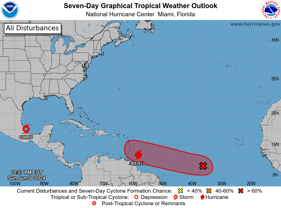
Chris90 wrote:Beryl is about the biggest warning shot you can possibly get for a hyperactive season. She has broken records from 1933 AND 2005.
Broke record for farthest east hurricane so early in the season, a title previously held by the 1933 Trinidad hurricane.
Broke record for earliest Category 4 hurricane in a season, a title previously held by Hurricane Dennis from 2005.
While 2020 holds record for storm count, 1933 and 2005 really are in a league of their own when it comes to intensity and ACE. I would honestly be surprised if 2024 doesn't manage to exceed 200 ACE.
August 20th is weeks away, but the bell is probably already rung. 1933 stayed active from June-October and 2005 stayed productive too. Most intense activity will almost assuredly occur during ASO like those seasons, but it wouldn't surprise me if July manages to produce another major.
The storm I've been thinking about recently is Lee and what he managed to pull off during a niño year. Some of those model runs were indicating a sub-900mb peak. I wonder if we'll see an open Atlantic CV hurricane go sub-900 this year now that a cool ENSO regime is taking over and giving the ATL a boost that Lee didn't have last year.


WeatherBoy2000 wrote:Even though most people are paying attention to Beryl, the Jul Cansip is out. Noticeable difference in the precip anomalies with this month's run compared to last month's for ASO. Lower in the eastern gulf and SE US, and higher for CA/Mexico/Texas. There's also more of a far east recurve signal as well:
This month:
https://www.tropicaltidbits.com/analysis/models/cansips/2024070100/cansips_apcpna_multimonth_atl_2.png
Last month:
https://www.tropicaltidbits.com/analysis/models/cansips/2024060100/cansips_apcpna_multimonth_atl_3.png
tiger_deF wrote:I think we will see a lull for a few weeks after Beryl, in thanks to the enormous SAL outbreak spurred on by the climatological peak and storms coming off of higher latitudes from the Sahara. That being said, once we truly enter the peak all bets are off. It only takes one…
tiger_deF wrote:I think we will see a lull for a few weeks after Beryl, in thanks to the enormous SAL outbreak spurred on by the climatological peak and storms coming off of higher latitudes from the Sahara. That being said, once we truly enter the peak all bets are off. It only takes one…
Chris90 wrote:Beryl is about the biggest warning shot you can possibly get for a hyperactive season. She has broken records from 1933 AND 2005.
Broke record for farthest east hurricane so early in the season, a title previously held by the 1933 Trinidad hurricane.
Broke record for earliest Category 4 hurricane in a season, a title previously held by Hurricane Dennis from 2005.
While 2020 holds record for storm count, 1933 and 2005 really are in a league of their own when it comes to intensity and ACE. I would honestly be surprised if 2024 doesn't manage to exceed 200 ACE.
August 20th is weeks away, but the bell is probably already rung. 1933 stayed active from June-October and 2005 stayed productive too. Most intense activity will almost assuredly occur during ASO like those seasons, but it wouldn't surprise me if July manages to produce another major.
The storm I've been thinking about recently is Lee and what he managed to pull off during a niño year. Some of those model runs were indicating a sub-900mb peak. I wonder if we'll see an open Atlantic CV hurricane go sub-900 this year now that a cool ENSO regime is taking over and giving the ATL a boost that Lee didn't have last year.


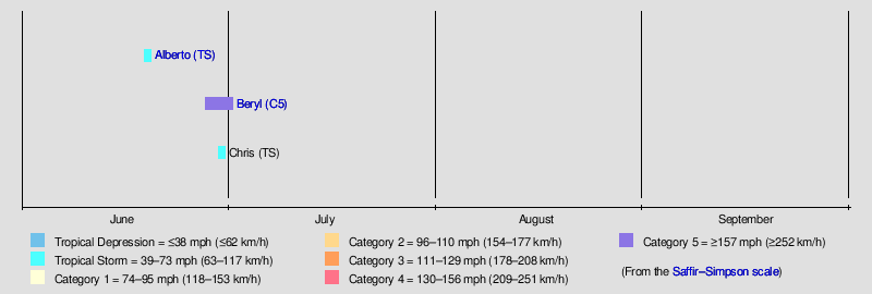
Teban54 wrote:Totally normal seasonal timeline:
https://i.postimg.cc/66VmXmWr/image.png
Users browsing this forum: No registered users and 211 guests


