2024 Indicators: SST's, MSLP, Shear, SAL, Steering, Instability (Day 16+ Climate Models)

This is the general tropical discussion area. Anyone can take their shot at predicting a storms path.

Moderator: S2k Moderators

Forum rules

The posts in this forum are NOT official forecasts and should not be used as such. They are just the opinion of the poster and may or may not be backed by sound meteorological data. They are NOT endorsed by any professional institution or STORM2K. For official information, please refer to products from the National Hurricane Center and National Weather Service.

Help Support Storm2K
Message
Author
User avatar
Teban54
Category 5
Category 5
Posts: 3206
Joined: Sat May 19, 2018 1:19 pm

Re: 2024 Indicators: SST's, MSLP, Shear, SAL, Steering, Instability (Day 16+ Climate Models)

#1341 Postby Teban54 » Sun Jun 30, 2024 9:04 am

tolakram wrote:Not an indicator but not sure where to drop these overview loops.

https://i.imgur.com/RFM1OXp.gif

The Atlantic, 2024: SAL? What?
0 likes   

User avatar
Category5Kaiju
Category 5
Category 5
Posts: 4097
Joined: Thu Dec 24, 2020 12:45 pm
Location: Seattle

Re: 2024 Indicators: SST's, MSLP, Shear, SAL, Steering, Instability (Day 16+ Climate Models)

#1342 Postby Category5Kaiju » Sun Jun 30, 2024 10:18 am

Teban54 wrote:
tolakram wrote:Not an indicator but not sure where to drop these overview loops.

https://i.imgur.com/RFM1OXp.gif

The Atlantic, 2024: SAL? What?


Beryl: spits in the face of climatology
3 likes   
Unless explicitly stated, all info in my posts is based on my own opinions and observations. Tropical storms and hurricanes can be extremely dangerous. Do not think you can beat Mother Nature. Refer to an accredited weather research agency or meteorologist if you need to make serious decisions regarding an approaching storm.

User avatar
FireRat
Category 5
Category 5
Posts: 1246
Age: 38
Joined: Sun Sep 26, 2010 11:38 pm
Location: North Carolina

Re: 2024 Indicators: SST's, MSLP, Shear, SAL, Steering, Instability (Day 16+ Climate Models)

#1343 Postby FireRat » Sun Jun 30, 2024 10:40 am

tolakram wrote:June 30th, crazy scene
https://i.imgur.com/s0v2VuF.png


Might as well be August 30th :double:
1 likes   
Georges '98, Irene '99, Frances '04, Jeanne '04, Katrina '05, Wilma '05, Gustav '08, Isaac '12, Matthew '16, Florence '18, Michael '18, Ian '22

User avatar
NotSparta
Professional-Met
Professional-Met
Posts: 1670
Age: 23
Joined: Fri Aug 18, 2017 8:24 am
Location: Naples, FL
Contact:

Re: 2024 Indicators: SST's, MSLP, Shear, SAL, Steering, Instability (Day 16+ Climate Models)

#1344 Postby NotSparta » Sun Jun 30, 2024 5:47 pm

Category 4 hurricane in the MDR before June is even over is about as reliable a signal as you can get for a hyperactive season. All those super aggressive ones everyone has made are certainly looking good right now
12 likes   
This post was probably an opinion of mine, and in no way is official. Please refer to http://www.hurricanes.gov for official tropical analysis and advisories.

My website, with lots of tropical wx graphics, including satellite and recon: http://cyclonicwx.com

User avatar
Category5Kaiju
Category 5
Category 5
Posts: 4097
Joined: Thu Dec 24, 2020 12:45 pm
Location: Seattle

Re: 2024 Indicators: SST's, MSLP, Shear, SAL, Steering, Instability (Day 16+ Climate Models)

#1345 Postby Category5Kaiju » Sun Jun 30, 2024 6:42 pm

At this point, assuming Beryl for whatever reason fails to achieve it, I'm expecting this season to produce several Category 5 hurricanes.

We've had hyperactive years (1995, 1999, 2010, and 2020 as examples) that didn't feature a single Category 5 hurricane. We've had hyperactive years (2003 and 2004 as examples) that featured one Category 5.

I genuinely believe this season will produce multiple Category 5 hurricanes, possibly even 3 or more. I can't believe I'm saying this, but here we go.
10 likes   
Unless explicitly stated, all info in my posts is based on my own opinions and observations. Tropical storms and hurricanes can be extremely dangerous. Do not think you can beat Mother Nature. Refer to an accredited weather research agency or meteorologist if you need to make serious decisions regarding an approaching storm.

User avatar
Teban54
Category 5
Category 5
Posts: 3206
Joined: Sat May 19, 2018 1:19 pm

Re: 2024 Indicators: SST's, MSLP, Shear, SAL, Steering, Instability (Day 16+ Climate Models)

#1346 Postby Teban54 » Sun Jun 30, 2024 9:59 pm

June 30, 2024
Image
3 likes   

LarryWx
S2K Supporter
S2K Supporter
Posts: 6305
Joined: Sun Sep 07, 2003 2:04 pm
Location: GA

Re: 2024 Indicators: SST's, MSLP, Shear, SAL, Steering, Instability (Day 16+ Climate Models)

#1347 Postby LarryWx » Sun Jun 30, 2024 10:51 pm

Total # of NS through July 1st (excluding NS before May 1):

2024: 3 with small chance for 4 due to 96L
2023: 3
2022: 3
2021: 5
2020: 4
2019: 1
2018: 1
2017: 2
2016: 3
2015: 2
2014: 1
2013: 2
2012: 4
2011: 1
2010: 1
2009: 0
2008: 1
2007: 2
2006: 1
2005: 2
2004: 0
2003: 1
2002: 0
2001: 1
2000: 0
1999: 1
1998: 0
1997: 2
1996: 1
1995: 1

AVG 1995-2023: 1.5

So, going back to 1995, only 2021, 2020, and 2012 had a higher #.
1 likes   
Personal Forecast Disclaimer:
The posts in this forum are NOT official forecasts and should not be used as such. They are just the opinion of the poster and may or may not be backed by sound meteorological data. They are NOT endorsed by any professional institution or storm2k.org. For official information, please refer to the NHC and NWS products.

Chris90
Category 2
Category 2
Posts: 646
Age: 35
Joined: Thu Jun 01, 2017 9:36 pm

Re: 2024 Indicators: SST's, MSLP, Shear, SAL, Steering, Instability (Day 16+ Climate Models)

#1348 Postby Chris90 » Mon Jul 01, 2024 2:13 am

Beryl is about the biggest warning shot you can possibly get for a hyperactive season. She has broken records from 1933 AND 2005.
Broke record for farthest east hurricane so early in the season, a title previously held by the 1933 Trinidad hurricane.
Broke record for earliest Category 4 hurricane in a season, a title previously held by Hurricane Dennis from 2005.

While 2020 holds record for storm count, 1933 and 2005 really are in a league of their own when it comes to intensity and ACE. I would honestly be surprised if 2024 doesn't manage to exceed 200 ACE.

August 20th is weeks away, but the bell is probably already rung. 1933 stayed active from June-October and 2005 stayed productive too. Most intense activity will almost assuredly occur during ASO like those seasons, but it wouldn't surprise me if July manages to produce another major.

The storm I've been thinking about recently is Lee and what he managed to pull off during a niño year. Some of those model runs were indicating a sub-900mb peak. I wonder if we'll see an open Atlantic CV hurricane go sub-900 this year now that a cool ENSO regime is taking over and giving the ATL a boost that Lee didn't have last year.
7 likes   
Solar Aquarian
Lunar Cancerian
:uarrow: Sagittarian

User avatar
Category5Kaiju
Category 5
Category 5
Posts: 4097
Joined: Thu Dec 24, 2020 12:45 pm
Location: Seattle

Re: 2024 Indicators: SST's, MSLP, Shear, SAL, Steering, Instability (Day 16+ Climate Models)

#1349 Postby Category5Kaiju » Mon Jul 01, 2024 6:43 am

Chris90 wrote:Beryl is about the biggest warning shot you can possibly get for a hyperactive season. She has broken records from 1933 AND 2005.
Broke record for farthest east hurricane so early in the season, a title previously held by the 1933 Trinidad hurricane.
Broke record for earliest Category 4 hurricane in a season, a title previously held by Hurricane Dennis from 2005.

While 2020 holds record for storm count, 1933 and 2005 really are in a league of their own when it comes to intensity and ACE. I would honestly be surprised if 2024 doesn't manage to exceed 200 ACE.

August 20th is weeks away, but the bell is probably already rung. 1933 stayed active from June-October and 2005 stayed productive too. Most intense activity will almost assuredly occur during ASO like those seasons, but it wouldn't surprise me if July manages to produce another major.

The storm I've been thinking about recently is Lee and what he managed to pull off during a niño year. Some of those model runs were indicating a sub-900mb peak. I wonder if we'll see an open Atlantic CV hurricane go sub-900 this year now that a cool ENSO regime is taking over and giving the ATL a boost that Lee didn't have last year.


It would really be something if we see a sub-900 storm. Only 5 have occurred since records started, with 2 of them from 2005.
3 likes   
Unless explicitly stated, all info in my posts is based on my own opinions and observations. Tropical storms and hurricanes can be extremely dangerous. Do not think you can beat Mother Nature. Refer to an accredited weather research agency or meteorologist if you need to make serious decisions regarding an approaching storm.

WeatherBoy2000
Category 1
Category 1
Posts: 346
Joined: Mon Apr 10, 2023 9:29 am

Re: 2024 Indicators: SST's, MSLP, Shear, SAL, Steering, Instability (Day 16+ Climate Models)

#1350 Postby WeatherBoy2000 » Mon Jul 01, 2024 8:03 am

Even though most people are paying attention to Beryl, the Jul Cansip is out. Noticeable difference in the precip anomalies with this month's run compared to last month's for ASO. Lower in the eastern gulf and SE US, and higher for CA/Mexico/Texas. There's also more of a far east recurve signal as well:

This month:
Image

Last month:
Image
4 likes   

User avatar
MetroMike
Category 4
Category 4
Posts: 952
Joined: Sun Aug 29, 2004 8:13 pm
Location: Tampa Bay
Contact:

Re: 2024 Indicators: SST's, MSLP, Shear, SAL, Steering, Instability (Day 16+ Climate Models)

#1351 Postby MetroMike » Mon Jul 01, 2024 4:04 pm

WeatherBoy2000 wrote:Even though most people are paying attention to Beryl, the Jul Cansip is out. Noticeable difference in the precip anomalies with this month's run compared to last month's for ASO. Lower in the eastern gulf and SE US, and higher for CA/Mexico/Texas. There's also more of a far east recurve signal as well:

This month:
https://www.tropicaltidbits.com/analysis/models/cansips/2024070100/cansips_apcpna_multimonth_atl_2.png

Last month:
https://www.tropicaltidbits.com/analysis/models/cansips/2024060100/cansips_apcpna_multimonth_atl_3.png


Just when the experts think they had seasons overall pattern trends figured out the Cansip shows us not so fast. Unless the thinking for Oct to have many re curves rather skews the overall map. By then the MDR season is pretty much over.
0 likes   

IcyTundra
Category 5
Category 5
Posts: 1205
Joined: Mon Jun 07, 2021 9:32 pm
Location: Dickinson, Texas

Re: 2024 Indicators: SST's, MSLP, Shear, SAL, Steering, Instability (Day 16+ Climate Models)

#1352 Postby IcyTundra » Mon Jul 01, 2024 5:41 pm

WeatherBoy2000 wrote:Even though most people are paying attention to Beryl, the Jul Cansip is out. Noticeable difference in the precip anomalies with this month's run compared to last month's for ASO. Lower in the eastern gulf and SE US, and higher for CA/Mexico/Texas. There's also more of a far east recurve signal as well:

This month:
https://www.tropicaltidbits.com/analysis/models/cansips/2024070100/cansips_apcpna_multimonth_atl_2.png

Last month:
https://www.tropicaltidbits.com/analysis/models/cansips/2024060100/cansips_apcpna_multimonth_atl_3.png


Slightly misleading if you just look at the ASO plots. Mostly skewed by the large below average precipitation area in the Gulf during October.
2 likes   

User avatar
Category5Kaiju
Category 5
Category 5
Posts: 4097
Joined: Thu Dec 24, 2020 12:45 pm
Location: Seattle

Re: 2024 Indicators: SST's, MSLP, Shear, SAL, Steering, Instability (Day 16+ Climate Models) July CanSIPS run up

#1353 Postby Category5Kaiju » Mon Jul 01, 2024 9:57 pm

We're doomed. :eek: :lol:
0 likes   
Unless explicitly stated, all info in my posts is based on my own opinions and observations. Tropical storms and hurricanes can be extremely dangerous. Do not think you can beat Mother Nature. Refer to an accredited weather research agency or meteorologist if you need to make serious decisions regarding an approaching storm.

User avatar
tiger_deF
Category 1
Category 1
Posts: 468
Age: 24
Joined: Tue Sep 27, 2016 11:47 am

Re: 2024 Indicators: SST's, MSLP, Shear, SAL, Steering, Instability (Day 16+ Climate Models) July CanSIPS run up

#1354 Postby tiger_deF » Mon Jul 01, 2024 10:00 pm

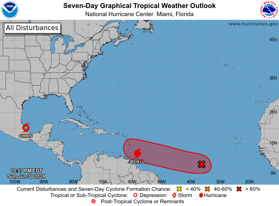
I think we will see a lull for a few weeks after Beryl, in thanks to the enormous SAL outbreak spurred on by the climatological peak and storms coming off of higher latitudes from the Sahara. That being said, once we truly enter the peak all bets are off. It only takes one…
4 likes   

User avatar
Category5Kaiju
Category 5
Category 5
Posts: 4097
Joined: Thu Dec 24, 2020 12:45 pm
Location: Seattle

Re: 2024 Indicators: SST's, MSLP, Shear, SAL, Steering, Instability (Day 16+ Climate Models) July CanSIPS run up

#1355 Postby Category5Kaiju » Mon Jul 01, 2024 10:31 pm

tiger_deF wrote:I think we will see a lull for a few weeks after Beryl, in thanks to the enormous SAL outbreak spurred on by the climatological peak and storms coming off of higher latitudes from the Sahara. That being said, once we truly enter the peak all bets are off. It only takes one…


Ngl, I wouldn't be surprised if the Atlantic decides to crank out another powerhouse, impactful Cape Verde hurricane by the end of this month. Kind of basing this off of the weirdo wacko storm that Beryl is, as well as how 2005 produced a Category 5 once every month from July to October (interestingly, near the ends of each month too).
2 likes   
Unless explicitly stated, all info in my posts is based on my own opinions and observations. Tropical storms and hurricanes can be extremely dangerous. Do not think you can beat Mother Nature. Refer to an accredited weather research agency or meteorologist if you need to make serious decisions regarding an approaching storm.

User avatar
Teban54
Category 5
Category 5
Posts: 3206
Joined: Sat May 19, 2018 1:19 pm

Re: 2024 Indicators: SST's, MSLP, Shear, SAL, Steering, Instability (Day 16+ Climate Models)

#1356 Postby Teban54 » Mon Jul 01, 2024 10:59 pm

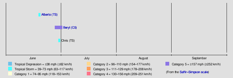
Totally normal seasonal timeline:
Image
9 likes   

CrazyC83
Professional-Met
Professional-Met
Posts: 34002
Joined: Tue Mar 07, 2006 11:57 pm
Location: Deep South, for the first time!

Re: 2024 Indicators: SST's, MSLP, Shear, SAL, Steering, Instability (Day 16+ Climate Models) July CanSIPS run up

#1357 Postby CrazyC83 » Mon Jul 01, 2024 11:03 pm

tiger_deF wrote:I think we will see a lull for a few weeks after Beryl, in thanks to the enormous SAL outbreak spurred on by the climatological peak and storms coming off of higher latitudes from the Sahara. That being said, once we truly enter the peak all bets are off. It only takes one…


That may only keep storms in check and not prevent waves from developing. We might go through several names there, only to have them dissipate quickly (or have to wait until near land).
1 likes   

User avatar
chaser1
S2K Supporter
S2K Supporter
Posts: 5464
Age: 64
Joined: Sat Oct 15, 2005 5:59 pm
Location: Longwood, Fl

Re: 2024 Indicators: SST's, MSLP, Shear, SAL, Steering, Instability (Day 16+ Climate Models)

#1358 Postby chaser1 » Tue Jul 02, 2024 1:55 am

Chris90 wrote:Beryl is about the biggest warning shot you can possibly get for a hyperactive season. She has broken records from 1933 AND 2005.
Broke record for farthest east hurricane so early in the season, a title previously held by the 1933 Trinidad hurricane.
Broke record for earliest Category 4 hurricane in a season, a title previously held by Hurricane Dennis from 2005.

While 2020 holds record for storm count, 1933 and 2005 really are in a league of their own when it comes to intensity and ACE. I would honestly be surprised if 2024 doesn't manage to exceed 200 ACE.

August 20th is weeks away, but the bell is probably already rung. 1933 stayed active from June-October and 2005 stayed productive too. Most intense activity will almost assuredly occur during ASO like those seasons, but it wouldn't surprise me if July manages to produce another major.

The storm I've been thinking about recently is Lee and what he managed to pull off during a niño year. Some of those model runs were indicating a sub-900mb peak. I wonder if we'll see an open Atlantic CV hurricane go sub-900 this year now that a cool ENSO regime is taking over and giving the ATL a boost that Lee didn't have last year.


Isaac just called looking for his weak little sister (Beryl) :double:
2 likes   
Andy D

(For official information, please refer to the NHC and NWS products.)

zzzh
Category 3
Category 3
Posts: 834
Joined: Thu Sep 02, 2021 1:13 pm

Re: 2024 Indicators: SST's, MSLP, Shear, SAL, Steering, Instability (Day 16+ Climate Models)

#1359 Postby zzzh » Tue Jul 02, 2024 2:27 am

Current Atlantic ace ranks 3rd since 1951, trailing 1951 (had a long lived subtropical hu), 1966 (had a major hurricane in the Gulf), it should be #1 tomorrow if those c5 wind maintains :D .
1 likes   

tolakram
Admin
Admin
Posts: 20009
Age: 62
Joined: Sun Aug 27, 2006 8:23 pm
Location: Florence, KY (name is Mark)

Re: 2024 Indicators: SST's, MSLP, Shear, SAL, Steering, Instability (Day 16+ Climate Models)

#1360 Postby tolakram » Tue Jul 02, 2024 7:13 am

Teban54 wrote:Totally normal seasonal timeline:
https://i.postimg.cc/66VmXmWr/image.png


A good example of why purple is not a good color for cat 5. Where's hink?
2 likes   
M a r k
- - - - -
Join us in chat: Storm2K Chatroom Invite. Android and IOS apps also available.

The posts in this forum are NOT official forecasts and should not be used as such. Posts are NOT endorsed by any professional institution or STORM2K.org. For official information and forecasts, please refer to NHC and NWS products.


Return to “Talkin' Tropics”

Who is online

Users browsing this forum: abajan, Hurricane2022, riapal, Stratton23, TampaWxLurker and 55 guests