
2024 WPAC Season
Moderator: S2k Moderators
Forum rules

The posts in this forum are NOT official forecasts and should not be used as such. They are just the opinion of the poster and may or may not be backed by sound meteorological data. They are NOT endorsed by any professional institution or STORM2K. For official information, please refer to products from the National Hurricane Center and National Weather Service.
-
cycloneye

- Admin

- Posts: 149696
- Age: 69
- Joined: Thu Oct 10, 2002 10:54 am
- Location: San Juan, Puerto Rico
Re: 2024 WPAC Season
The basin may have it's first tropical cyclone of 2024 by next weekend. This from the Guan NWS.
0 likes
Visit the Caribbean-Central America Weather Thread where you can find at first post web cams,radars
and observations from Caribbean basin members Click Here
and observations from Caribbean basin members Click Here
-
doomhaMwx

- Category 5

- Posts: 2494
- Age: 27
- Joined: Tue Apr 18, 2017 4:01 am
- Location: Baguio/Benguet, Philippines
- Contact:
Re: 2024 WPAC Season
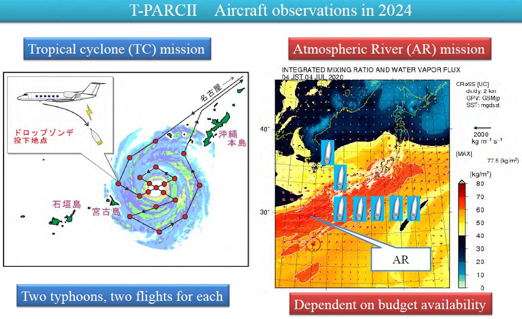
Japan plans to conduct aircraft reconnaissance missions into two typhoons this 2024, with each system getting two flights.
11 likes
-
cycloneye
- Admin
- Posts: 149696
- Age: 69
- Joined: Thu Oct 10, 2002 10:54 am
- Location: San Juan, Puerto Rico
Re: 2024 WPAC Season
0 likes
Visit the Caribbean-Central America Weather Thread where you can find at first post web cams,radars
and observations from Caribbean basin members Click Here
and observations from Caribbean basin members Click Here

Re: 2024 WPAC Season
A near term low formation is being shown by the GFS and Euro but no significant development (we'll see) and about the after June 20 possible development, GFS long range is showing it.
0 likes
ヤンデレ女が寝取られるているのを見たい!!!
ECMWF ensemble NWPAC plots: https://ecmwfensnwpac.imgbb.com/
Multimodel NWPAC plots: https://multimodelnwpac.imgbb.com/
GFS Ensemble NWPAC plots (16 & 35 day forecast): https://gefsnwpac.imgbb.com/
Plots updated automatically
ECMWF ensemble NWPAC plots: https://ecmwfensnwpac.imgbb.com/
Multimodel NWPAC plots: https://multimodelnwpac.imgbb.com/
GFS Ensemble NWPAC plots (16 & 35 day forecast): https://gefsnwpac.imgbb.com/
Plots updated automatically
Re: 2024 WPAC Season
We may finally get tropical development again by mid July if the GFS is right
0 likes
ヤンデレ女が寝取られるているのを見たい!!!
ECMWF ensemble NWPAC plots: https://ecmwfensnwpac.imgbb.com/
Multimodel NWPAC plots: https://multimodelnwpac.imgbb.com/
GFS Ensemble NWPAC plots (16 & 35 day forecast): https://gefsnwpac.imgbb.com/
Plots updated automatically
ECMWF ensemble NWPAC plots: https://ecmwfensnwpac.imgbb.com/
Multimodel NWPAC plots: https://multimodelnwpac.imgbb.com/
GFS Ensemble NWPAC plots (16 & 35 day forecast): https://gefsnwpac.imgbb.com/
Plots updated automatically
Re: 2024 WPAC Season
GFS literally thinks it's El Nino this year, it has WWB all the way to CPAC  , EPS is a lot more reasonable with some slow development near the Philippines.
1 likes
-
dexterlabio
- Category 5
- Posts: 3517
- Joined: Sat Oct 24, 2009 11:50 pm
Re: 2024 WPAC Season
^Well the ENSO state is neutral so anything Niño-like or Niña-like can happen, but I'm inclined to think that we're heading steadily to a weak La Niña setup.
0 likes
Personal Forecast Disclaimer:
The posts in this forum are NOT official forecast and should not be used as such. They are just the opinion of the poster and may or may not be backed by sound meteorological data. They are NOT endorsed by any professional institution or storm2k.org. For official information, please refer to the NHC and NWS products.
The posts in this forum are NOT official forecast and should not be used as such. They are just the opinion of the poster and may or may not be backed by sound meteorological data. They are NOT endorsed by any professional institution or storm2k.org. For official information, please refer to the NHC and NWS products.
-
doomhaMwx
- Category 5
- Posts: 2494
- Age: 27
- Joined: Tue Apr 18, 2017 4:01 am
- Location: Baguio/Benguet, Philippines
- Contact:
Re: 2024 WPAC Season
doomhaMwx wrote:Japan plans to conduct aircraft reconnaissance missions into two typhoons this 2024, with each system getting two flights.
https://pbs.twimg.com/media/GO8MehhbEAIyP2f?format=jpg&name=medium
Aside from recon, Japan is also currently deploying VM drones east of the Philippines to gather valuable data in typhoons, including winds and pressure!
https://x.com/doomhaMwx/status/1809151477354766803
1 likes
Re: 2024 WPAC Season
https://www.tropicalstormrisk.com/docs/TSRNWPForecastJuly2024.pdf
TSR July update. A bit less active than the May forecast.
TSR July update. A bit less active than the May forecast.
0 likes
-
cycloneye
- Admin
- Posts: 149696
- Age: 69
- Joined: Thu Oct 10, 2002 10:54 am
- Location: San Juan, Puerto Rico
Re: 2024 WPAC Season
0 likes
Visit the Caribbean-Central America Weather Thread where you can find at first post web cams,radars
and observations from Caribbean basin members Click Here
and observations from Caribbean basin members Click Here
-
xtyphooncyclonex

- Category 5
- Posts: 3898
- Age: 24
- Joined: Sat Dec 08, 2012 9:07 am
- Location: Cebu City
- Contact:
Re: 2024 WPAC Season
In all honesty, I would expect a more active season than first thought. We initially anticipated a weak-moderate La Nina to emerge at this point --- as aggressively pushed by the CFSv2 and others --- which would lead to a 2010-esque dead season.
We're already in mid-July and the base state seems to be a warm neutral setup. There could be a sudden burst of activity akin to 2016, but not enough to catapult us out of the below-average ACE streak since 2019. I expect it to happen in a CCKW/strong MJO in the middle of the season. However, convective activity and genesis these past two years has been... dead. The WPac can prove me wrong though..
I do hope land impacts would be as minimal as can be, and we could see a couple intense long-tracking fish amidst the predictions. The Pacific needs more, the land needs less.
0 likes
REMINDER: My opinions that I, or any other NON Pro-Met in this forum, are unofficial. Please do not take my opinions as an official forecast and warning. I am NOT a meteorologist. Following my forecasts blindly may lead to false alarm, danger and risk if official forecasts from agencies are ignored.
-
dexterlabio
- Category 5
- Posts: 3517
- Joined: Sat Oct 24, 2009 11:50 pm
Re: 2024 WPAC Season
A careful look at the past 15 years will show us that PDO goes hand in hand with ENSO to influence TC activity in the Pacific. 2009 and 2023 are examples of moderate to strong +ENSO events that did not translate to above average typhoon seasons. Yes, a couple of intense typhoons were spawned but these were not enough to push those years into classic El Niño hyperactivity.
One can only imagine the level of inactivity this year will have with -PDO and the anticipated dive into -ENSO in the later months. While a surprise late season burst of activity like in 2016 is still a possibility, keep in mind that 2016 came out of a pretty solid +PDO year.
One can only imagine the level of inactivity this year will have with -PDO and the anticipated dive into -ENSO in the later months. While a surprise late season burst of activity like in 2016 is still a possibility, keep in mind that 2016 came out of a pretty solid +PDO year.
0 likes
Personal Forecast Disclaimer:
The posts in this forum are NOT official forecast and should not be used as such. They are just the opinion of the poster and may or may not be backed by sound meteorological data. They are NOT endorsed by any professional institution or storm2k.org. For official information, please refer to the NHC and NWS products.
The posts in this forum are NOT official forecast and should not be used as such. They are just the opinion of the poster and may or may not be backed by sound meteorological data. They are NOT endorsed by any professional institution or storm2k.org. For official information, please refer to the NHC and NWS products.
-
Hurricane2022

- Category 5
- Posts: 2090
- Joined: Tue Aug 23, 2022 11:38 pm
- Location: Araçatuba, Brazil
Re: 2024 WPAC Season
aaaaaaaaaaaaaaaaaaaaaaaaAAAAAAAAAAAAAAAAAAAAAAAAAAAAAAAAAAAAAAAAaaaaaaaaaaaaaaaaaaaaaaaa
1 likes
Sorry for the bad English sometimes...!
For reliable and detailed information for any meteorological phenomenon, please consult the National Hurricane Center, Joint Typhoon Warning Center , or your local Meteo Center.
--------
ECCE OMNIA NOVA FACIAM (Ap 21,5).
For reliable and detailed information for any meteorological phenomenon, please consult the National Hurricane Center, Joint Typhoon Warning Center , or your local Meteo Center.
--------
ECCE OMNIA NOVA FACIAM (Ap 21,5).
-
cycloneye
- Admin
- Posts: 149696
- Age: 69
- Joined: Thu Oct 10, 2002 10:54 am
- Location: San Juan, Puerto Rico
Re: 2024 WPAC Season
0 likes
Visit the Caribbean-Central America Weather Thread where you can find at first post web cams,radars
and observations from Caribbean basin members Click Here
and observations from Caribbean basin members Click Here
-
xtyphooncyclonex
- Category 5
- Posts: 3898
- Age: 24
- Joined: Sat Dec 08, 2012 9:07 am
- Location: Cebu City
- Contact:
Re: 2024 WPAC Season
GFS and CMC develop a mid-level TS just east of Visayas-Mindanao in around TAU 84-90.
1 likes
REMINDER: My opinions that I, or any other NON Pro-Met in this forum, are unofficial. Please do not take my opinions as an official forecast and warning. I am NOT a meteorologist. Following my forecasts blindly may lead to false alarm, danger and risk if official forecasts from agencies are ignored.

Re: 2024 WPAC Season
1 likes
TC naming lists: retirements and intensity
Most aggressive Advisory #1's in North Atlantic (cr. kevin for starting the list)
Most aggressive Advisory #1's in North Atlantic (cr. kevin for starting the list)
-
Hurricane2022
- Category 5
- Posts: 2090
- Joined: Tue Aug 23, 2022 11:38 pm
- Location: Araçatuba, Brazil
Re: 2024 WPAC Season
It is in my personal interest to know what drug GFS is snorting or smoking.

6 likes
Sorry for the bad English sometimes...!
For reliable and detailed information for any meteorological phenomenon, please consult the National Hurricane Center, Joint Typhoon Warning Center , or your local Meteo Center.
--------
ECCE OMNIA NOVA FACIAM (Ap 21,5).
For reliable and detailed information for any meteorological phenomenon, please consult the National Hurricane Center, Joint Typhoon Warning Center , or your local Meteo Center.
--------
ECCE OMNIA NOVA FACIAM (Ap 21,5).
-
Kingarabian

- S2K Supporter

- Posts: 16377
- Joined: Sat Aug 08, 2009 3:06 am
- Location: Honolulu, Hawaii
Re: 2024 WPAC Season
Hurricane2022 wrote:It is in my personal interest to know what drug GFS is snorting or smoking.
https://imageshack.com/i/pmONNxb0p
Common bias when the MJO passes or is about to pass. But at least there's Gaemi to show for it.
1 likes
RIP Kobe Bryant
Re: 2024 WPAC Season
Looks like the next tropical development would occur above the tropic of cancer but the model solutions show a very if not extremely complicated setup...
0 likes
ヤンデレ女が寝取られるているのを見たい!!!
ECMWF ensemble NWPAC plots: https://ecmwfensnwpac.imgbb.com/
Multimodel NWPAC plots: https://multimodelnwpac.imgbb.com/
GFS Ensemble NWPAC plots (16 & 35 day forecast): https://gefsnwpac.imgbb.com/
Plots updated automatically
ECMWF ensemble NWPAC plots: https://ecmwfensnwpac.imgbb.com/
Multimodel NWPAC plots: https://multimodelnwpac.imgbb.com/
GFS Ensemble NWPAC plots (16 & 35 day forecast): https://gefsnwpac.imgbb.com/
Plots updated automatically
-
Hurricane2022
- Category 5
- Posts: 2090
- Joined: Tue Aug 23, 2022 11:38 pm
- Location: Araçatuba, Brazil
Re: 2024 WPAC Season
It's an satellite error or the waters between China and Japan (subtropical region!!) are around 32 - 33 °C??? 

1 likes
Sorry for the bad English sometimes...!
For reliable and detailed information for any meteorological phenomenon, please consult the National Hurricane Center, Joint Typhoon Warning Center , or your local Meteo Center.
--------
ECCE OMNIA NOVA FACIAM (Ap 21,5).
For reliable and detailed information for any meteorological phenomenon, please consult the National Hurricane Center, Joint Typhoon Warning Center , or your local Meteo Center.
--------
ECCE OMNIA NOVA FACIAM (Ap 21,5).
Who is online
Users browsing this forum: No registered users and 189 guests