Possible development in the Western Atlantic / GOM (Is Invest 97L)

This is the general tropical discussion area. Anyone can take their shot at predicting a storms path.

Moderator: S2k Moderators

Forum rules

The posts in this forum are NOT official forecasts and should not be used as such. They are just the opinion of the poster and may or may not be backed by sound meteorological data. They are NOT endorsed by any professional institution or STORM2K. For official information, please refer to products from the National Hurricane Center and National Weather Service.

Help Support Storm2K
Message
Author
User avatar
Spacecoast
Category 2
Category 2
Posts: 758
Joined: Thu Aug 31, 2017 2:03 pm

Re: Possible development in the central Atlantic (0/50)

#201 Postby Spacecoast » Mon Jul 29, 2024 10:49 am

CMC, Euro, & UK show genesis probability of 51% near SFL....
Image
Image
Image

Image
2 likes   

Frank P
S2K Supporter
S2K Supporter
Posts: 2776
Joined: Fri Aug 29, 2003 10:52 am
Location: Biloxi Beach, Ms
Contact:

Re: Possible development in the central Atlantic (0/50)

#202 Postby Frank P » Mon Jul 29, 2024 10:54 am

I don't ever recall tracking an uglier wave for as long as I have been tracking on this system...
4 likes   

User avatar
boca
Category 5
Category 5
Posts: 6367
Age: 60
Joined: Mon Dec 15, 2003 8:49 am
Location: Boca Raton,FL

Re: Possible development in the central Atlantic (0/50)

#203 Postby boca » Mon Jul 29, 2024 11:01 am

Tracking this system is like waiting on an afternoon thunderstorm that never materializes.
3 likes   

User avatar
wxman57
Moderator-Pro Met
Moderator-Pro Met
Posts: 22978
Age: 67
Joined: Sat Jun 21, 2003 8:06 pm
Location: Houston, TX (southwest)

Re: Possible development in the central Atlantic (0/50)

#204 Postby wxman57 » Mon Jul 29, 2024 11:06 am

The real feature is the very large wave just behind the one the NHC mentions. It will be overtaking the first wave and adding its energy to the mix. Neither has much convection now, but that should change near the Bahamas or in the eastern Gulf on Saturday. I think NHC will be bumping chances up to 70-80% by Wednesday, with development just beyond 48 hours by then. I'm thinking that chances are as high as 90% by this weekend. Another working weekend for me. We already have clients requesting conference calls.
32 likes   

lsuhurricane
Category 1
Category 1
Posts: 251
Joined: Tue Aug 15, 2017 2:53 pm

Re: Possible development in the central Atlantic (0/50)

#205 Postby lsuhurricane » Mon Jul 29, 2024 11:23 am

12z GFS continues to keep this strung out and finally consolidates a vort near the FL/AL coastline. Does have some ensemble support for that...so who knows
0 likes   

LarryWx
S2K Supporter
S2K Supporter
Posts: 6304
Joined: Sun Sep 07, 2003 2:04 pm
Location: GA

Re: Possible development in the central Atlantic (0/50)

#206 Postby LarryWx » Mon Jul 29, 2024 11:26 am

12Z UKMET: still has a TD though not as strong as the 0Z’s TS that had skimmed the SE FL coast at Palm Beach. The new run delays TCG til it is 50 miles NE of Cape Canaveral. It then moves NE to 150 miles E of Amelia Island, FL:

NEW TROPICAL CYCLONE FORECAST TO DEVELOP AFTER 156 HOURS
FORECAST POSITION AT T+156 : 29.0N 80.1W

LEAD CENTRAL MAXIMUM WIND
VERIFYING TIME TIME POSITION PRESSURE (MB) SPEED (KNOTS)
-------------- ---- -------- ------------- -------------
0000UTC 05.08.2024 156 29.0N 80.1W 1008 31
1200UTC 05.08.2024 168 30.6N 79.0W 1008 34
0 likes   
Personal Forecast Disclaimer:
The posts in this forum are NOT official forecasts and should not be used as such. They are just the opinion of the poster and may or may not be backed by sound meteorological data. They are NOT endorsed by any professional institution or storm2k.org. For official information, please refer to the NHC and NWS products.

Stratton23
Category 5
Category 5
Posts: 2518
Joined: Fri Jul 21, 2023 10:59 pm
Location: Katy, Tx

Re: Possible development in the central Atlantic (0/50)

#207 Postby Stratton23 » Mon Jul 29, 2024 11:27 am

Big difference in models, GFS has more of a blocking pattern and cuts off the weakness to its north, not allowing for an escape path up the east coast or out to sea
0 likes   

BobHarlem
Category 5
Category 5
Posts: 2104
Joined: Thu Oct 20, 2005 6:11 pm

Re: Possible development in the central Atlantic (0/50)

#208 Postby BobHarlem » Mon Jul 29, 2024 11:39 am

Interesting how the 12z gfs just stalls it offshore of MS/LA for like most of next week (Monday night-Friday)
0 likes   

LarryWx
S2K Supporter
S2K Supporter
Posts: 6304
Joined: Sun Sep 07, 2003 2:04 pm
Location: GA

Re: Possible development in the central Atlantic (0/50)

#209 Postby LarryWx » Mon Jul 29, 2024 11:49 am

12Z CMC is further E and much weaker with just a weak low over SE FL/NW Bahamas. But then it gets stronger as it moves NE offshore NC and becomes a TS moving further OTS.
0 likes   
Personal Forecast Disclaimer:
The posts in this forum are NOT official forecasts and should not be used as such. They are just the opinion of the poster and may or may not be backed by sound meteorological data. They are NOT endorsed by any professional institution or storm2k.org. For official information, please refer to the NHC and NWS products.

User avatar
toad strangler
S2K Supporter
S2K Supporter
Posts: 4543
Joined: Sun Jul 28, 2013 3:09 pm
Location: Earth
Contact:

Re: Possible development in the central Atlantic (0/50)

#210 Postby toad strangler » Mon Jul 29, 2024 12:47 pm

12z Euro weakish 1008mb and comes close to the FL peninsula before moving N into SC and seems to stall just inland.... hardly moving 192 hours through to end at 240.
1 likes   

User avatar
SFLcane
S2K Supporter
S2K Supporter
Posts: 10163
Age: 47
Joined: Sat Jun 05, 2010 1:44 pm
Location: Lake Worth Florida

Re: Possible development in the central Atlantic (0/50)

#211 Postby SFLcane » Mon Jul 29, 2024 12:57 pm

Image
1 likes   

jlauderdal
S2K Supporter
S2K Supporter
Posts: 7182
Joined: Wed May 19, 2004 5:46 am
Location: NE Fort Lauderdale
Contact:

Re: Possible development in the central Atlantic (0/50)

#212 Postby jlauderdal » Mon Jul 29, 2024 1:13 pm


No sweat, clean side of the storm. If the EPS weren't trending offshore I would be on orange alert.
0 likes   

BobHarlem
Category 5
Category 5
Posts: 2104
Joined: Thu Oct 20, 2005 6:11 pm

Re: Possible development in the central Atlantic (0/50)

#213 Postby BobHarlem » Mon Jul 29, 2024 1:13 pm

That stall on both models (GFS around MS/LA and Euro with the South Carolina low country, even though it goes to different spots) is concerning for flooding.
0 likes   

User avatar
toad strangler
S2K Supporter
S2K Supporter
Posts: 4543
Joined: Sun Jul 28, 2013 3:09 pm
Location: Earth
Contact:

Re: Possible development in the central Atlantic (0/50)

#214 Postby toad strangler » Mon Jul 29, 2024 1:19 pm

12z UKMET landfalls a depression probably in Broward / Palm Beach County area at 138 hours and exits up by Cape Canaveral just after 150 hours heading NNE towards Hatteras.
0 likes   

Stratton23
Category 5
Category 5
Posts: 2518
Joined: Fri Jul 21, 2023 10:59 pm
Location: Katy, Tx

Re: Possible development in the central Atlantic (0/50)

#215 Postby Stratton23 » Mon Jul 29, 2024 1:22 pm

BobHarlem yep, once that shortwave leaves the picture, the system could get trapped by ridging until the next trough swings by , if that occurs in the gulf or off the se coast remains to be seen, but definitely concerning seeing that, we know all too well about stalling systems in texas, that would be bad for the se US coast
0 likes   

User avatar
SFLcane
S2K Supporter
S2K Supporter
Posts: 10163
Age: 47
Joined: Sat Jun 05, 2010 1:44 pm
Location: Lake Worth Florida

Re: Possible development in the central Atlantic (0/50)

#216 Postby SFLcane » Mon Jul 29, 2024 1:26 pm

jlauderdal wrote:

No sweat, clean side of the storm. If the EPS weren't trending offshore I would be on orange alert.


No coherent disturbance so we wait. Not looking for a major here which is surely not required for some impacts.
2 likes   

User avatar
Blown Away
S2K Supporter
S2K Supporter
Posts: 10145
Joined: Wed May 26, 2004 6:17 am

Re: Possible development in the central Atlantic (0/50)

#217 Postby Blown Away » Mon Jul 29, 2024 1:32 pm

Image
12z Euro slight trend W near FL. Marginal TS just off the coast moving towards Carolinas…
0 likes   
Hurricane Eye Experience: David 79, Irene 99, Frances 04, Jeanne 04, Wilma 05... EYE COMING MY WAY IN 2024…
Hurricane Brush Experience: Andrew 92, Erin 95, Floyd 99, Matthew 16, Irma 17, Ian 22, Nicole 22…

jlauderdal
S2K Supporter
S2K Supporter
Posts: 7182
Joined: Wed May 19, 2004 5:46 am
Location: NE Fort Lauderdale
Contact:

Re: Possible development in the central Atlantic (0/50)

#218 Postby jlauderdal » Mon Jul 29, 2024 1:33 pm

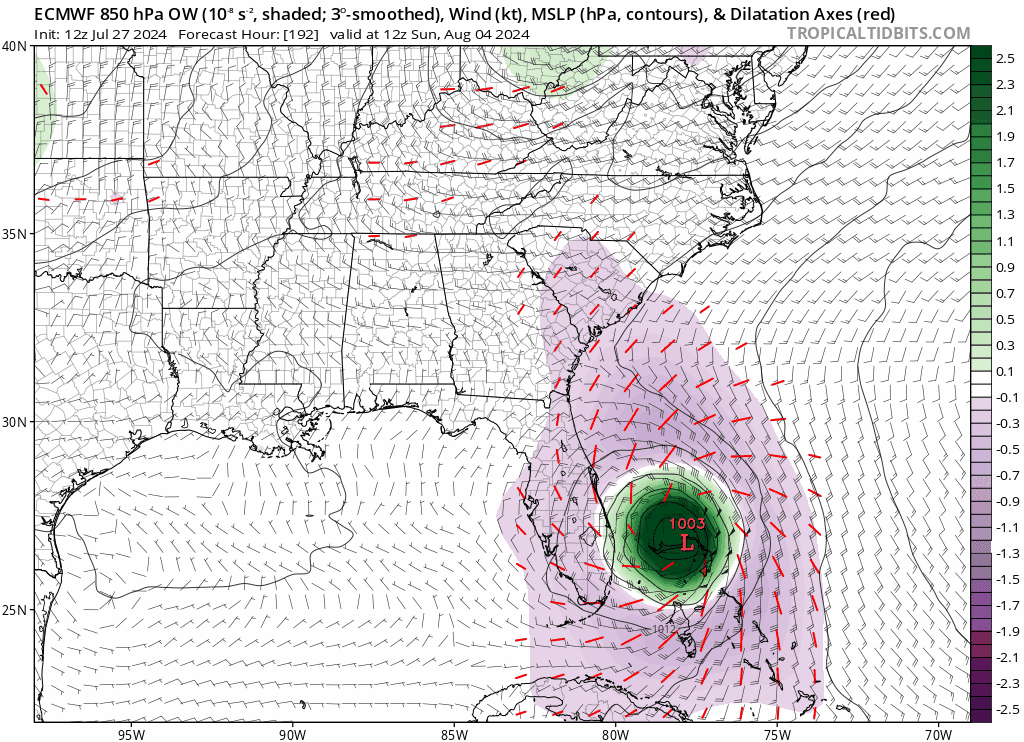
toad strangler wrote:12z UKMET landfalls a depression probably in Broward / Palm Beach County area at 138 hours and exits up by Cape Canaveral just after 150 hours heading NNE towards Hatteras.

We will take that as long as it keeps moving, we have had three big rain events in 16 months, no sympathy from Houston in the department to be sure, they have been pounded for a few years.
0 likes   

User avatar
ConvergenceZone
Category 5
Category 5
Posts: 5194
Joined: Fri Jul 29, 2005 1:40 am
Location: Northern California

Re: Possible development in the central Atlantic (0/50)

#219 Postby ConvergenceZone » Mon Jul 29, 2024 1:33 pm

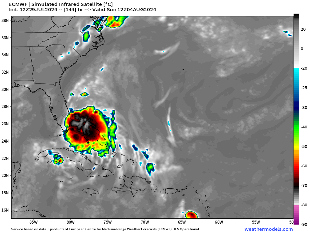
wxman57 wrote:The real feature is the very large wave just behind the one the NHC mentions. It will be overtaking the first wave and adding its energy to the mix. Neither has much convection now, but that should change near the Bahamas or in the eastern Gulf on Saturday. I think NHC will be bumping chances up to 70-80% by Wednesday, with development just beyond 48 hours by then. I'm thinking that chances are as high as 90% by this weekend. Another working weekend for me. We already have clients requesting conference calls.


Wait, wxman is actually bullish on the formation of a storm? What just happened? :) Doesn't look like it will be much of a storm though if the models are to be trusted.
2 likes   

Stratton23
Category 5
Category 5
Posts: 2518
Joined: Fri Jul 21, 2023 10:59 pm
Location: Katy, Tx

Re: Possible development in the central Atlantic (0/50)

#220 Postby Stratton23 » Mon Jul 29, 2024 1:39 pm

Yeah the GFS/ Euro both have a pattern that could lead to a stall for multiple days , definitely worth monitoring
0 likes   


Return to “Talkin' Tropics”

Who is online

Users browsing this forum: KeysRedWine and 39 guests