Possible development in the Western Atlantic / GOM (Is Invest 97L)
Moderator: S2k Moderators
Forum rules

The posts in this forum are NOT official forecasts and should not be used as such. They are just the opinion of the poster and may or may not be backed by sound meteorological data. They are NOT endorsed by any professional institution or STORM2K. For official information, please refer to products from the National Hurricane Center and National Weather Service.

Re: Possible development in the Western Atlantic / GOM (10/60)
At some point there is definitely going to be a breakdown in the steering and whatever exists will be looping back to the west as high pressure builds back in. The big question will be where is it when it stalls and where does it loop back to the west?
1 likes
-
toad strangler

- S2K Supporter

- Posts: 4546
- Joined: Sun Jul 28, 2013 3:09 pm
- Location: Earth
- Contact:
Re: Possible development in the Western Atlantic / GOM (10/60)
6z GFS Ensembles are spread pretty evenly from NE GOM / FL / GA / SC / OFF SE COAST
0 likes
My Weather Station
https://www.wunderground.com/dashboard/pws/KFLPORTS603
https://www.wunderground.com/dashboard/pws/KFLPORTS603
-
Blown Away

- S2K Supporter
- Posts: 10253
- Joined: Wed May 26, 2004 6:17 am
Re: Possible development in the Western Atlantic / GOM (10/60)

NHC 2am is basically over PR and much of the deeper convection with a hint of rotation, probably mid level, is to the N. If this AOI consolidates even 100 miles N of PR/Hispaniola and current NHC track, it may develop quicker and turn pretty much into Florida. I still wouldn't rule out E of Florida if it develops quickly... JMHO
0 likes
Hurricane Eye Experience: David 79, Irene 99, Frances 04, Jeanne 04, Wilma 05… Hurricane Brush Experience: Andrew 92, Erin 95, Floyd 99, Matthew 16, Irma 17, Ian 22, Nicole 22…

Re: Possible development in the Western Atlantic / GOM (10/60)
toad strangler wrote:6z GFS Ensembles are spread pretty evenly from NE GOM / FL / GA / SC / OFF SE COAST

Sent from my iPhone using Tapatalk
3 likes
-
toad strangler
- S2K Supporter
- Posts: 4546
- Joined: Sun Jul 28, 2013 3:09 pm
- Location: Earth
- Contact:

Re: Possible development in the Western Atlantic / GOM (10/60)
Interesting the 500mb vort is currently south of PR.
This could stay south of the Antilles all together and enter the GoM well structured.
This could stay south of the Antilles all together and enter the GoM well structured.
0 likes
Re: Possible development in the Western Atlantic / GOM (10/60)
I do not see the ML rotation at all N of PR. I think it is pretty evident it is to the south and off the west end of PR at this time. We shall see.Blown Away wrote:[url]https://i.postimg.cc/LXzcCyny/goes16-ir-watl-6.gif [/url]
[url]https://i.postimg.cc/SsrZYHXp/NHC-2am.jpg [/url]
NHC 2am is basically over PR and much of the deeper convection with a hint of rotation, probably mid level, is to the N. If this AOI consolidates even 100 miles N of PR/Hispaniola and current NHC track, it may develop quicker and turn pretty much into Florida. I still wouldn't rule out E of Florida if it develops quickly... JMHO
0 likes
-
HurricaneBelle

- S2K Supporter
- Posts: 1209
- Joined: Sun Aug 27, 2006 6:12 pm
- Location: Clearwater, FL
Re: Possible development in the Western Atlantic / GOM (10/60)
toad strangler wrote:https://twitter.com/andyhazelton/status/1818971497639063867?s=46
Remember Elena quite well, I was at the University of Florida at the time and during the week it was supposed to come into the Gulf and landfall along MS/AL. On the Friday drove home to the Tampa Bay area for Labor Day weekend with a friend and we hit a pretty good storm along the way on I-75 and joked that maybe Elena made a right turn and was coming our way, and then as soon as we got home it was on the news that Elena had indeed made an unexpected right turn toward the FL west coast and we were under watches/warnings. Then we watched it essentially stall for 48 hours off the coast. Ironically when it started moving again it ended up right where it was originally forecast after a 3-day detour.
3 likes
Re: Possible development in the Western Atlantic / GOM (10/60)
A center of whatever exist is clearly evident on San Juan radar. There is nothing of a rotation whatsoever north of Puerto Rico. And the rotation is over open water. Should be an interesting day.
0 likes
Re: Possible development in the Western Atlantic / GOM (10/60)
GFS is not correctly initializing the 500mb vort correctly.
CIMSS shows a closed tight structure with associated convection.
GFS has it as an open-wave structure.
One thing of note is that once this gets in the east GoM a well-defined anti-cyclone will phase with this.
CIMSS shows a closed tight structure with associated convection.
GFS has it as an open-wave structure.
One thing of note is that once this gets in the east GoM a well-defined anti-cyclone will phase with this.
Last edited by GCANE on Thu Aug 01, 2024 7:03 am, edited 1 time in total.
0 likes
-
gulf701
- Tropical Depression

- Posts: 65
- Age: 76
- Joined: Mon Jun 14, 2010 4:43 pm
- Location: Wewahitchka, FL
Re: Possible development in the Western Atlantic / GOM (10/60)
National Weather Service Tallahassee FL
629 AM EDT Thu Aug 1 2024
...Interests across our region should monitor the progress of a
tropical wave near Puerto Rico that could develop into a tropical
depression over the eastern Gulf this weekend or early next
week...
629 AM EDT Thu Aug 1 2024
...Interests across our region should monitor the progress of a
tropical wave near Puerto Rico that could develop into a tropical
depression over the eastern Gulf this weekend or early next
week...
Tallahassee has a good analysis about the subject in their AM discussion.
0 likes
-
cycloneye

- Admin

- Posts: 149730
- Age: 69
- Joined: Thu Oct 10, 2002 10:54 am
- Location: San Juan, Puerto Rico
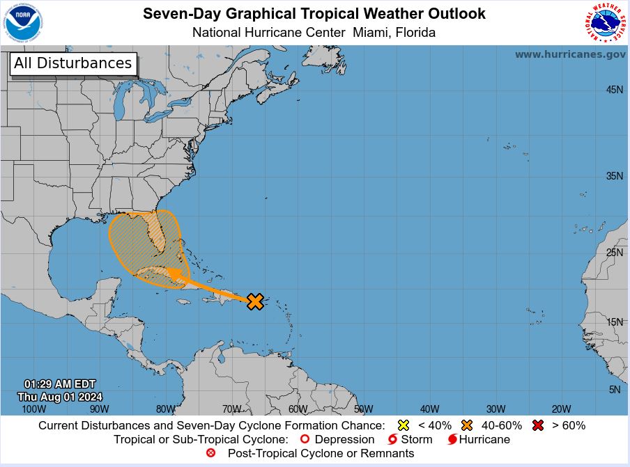
Re: Possible development in the Western Atlantic / GOM (20/60)
Now that is at 20% in two days, there is a great chance that it will be invest 97L very soon. 
1 likes
Visit the Caribbean-Central America Weather Thread where you can find at first post web cams,radars
and observations from Caribbean basin members Click Here
and observations from Caribbean basin members Click Here

Re: Possible development in the Western Atlantic / GOM (10/60)
Boy, tough call on position. Broadly speaking, I'd paint an X around the Mona Passage. Biggest pressure falls over the past 24 hr.'s have been around and just north of the Passage. On the other hand I also see what appears to be some vorticity max southwest of Ponce around 16N. Seems as if the trough axis has a NNW/SSE tilt. Will be very interesting to watch the entire feature become bisected by Hispaniola and consolidation could well begin to occur either side of the Island. I'm leaning south side but a north side development would certainly hasten PTC advisories for S. Florida. Looks like NHC just bumped up to 20% for near term; given the increase in convection along with the possibility of a COC attempting to form north or south of the Greater Antilles I might have thought that number might had been a little higher. With the increased model support I'm thinking 30/70 at 2:00pm.
0 likes
Andy D
(For official information, please refer to the NHC and NWS products.)
(For official information, please refer to the NHC and NWS products.)
-
toad strangler
- S2K Supporter
- Posts: 4546
- Joined: Sun Jul 28, 2013 3:09 pm
- Location: Earth
- Contact:
Re: Possible development in the Western Atlantic / GOM (20/60)
NHC update has this disturbance tagged right at 70W over Hispaniola and looks to take it right down the spine of the rest of the GA's.
0 likes
My Weather Station
https://www.wunderground.com/dashboard/pws/KFLPORTS603
https://www.wunderground.com/dashboard/pws/KFLPORTS603
-
cycloneye
- Admin
- Posts: 149730
- Age: 69
- Joined: Thu Oct 10, 2002 10:54 am
- Location: San Juan, Puerto Rico
Re: Possible development in the Western Atlantic / GOM (20/60)
1 likes
Visit the Caribbean-Central America Weather Thread where you can find at first post web cams,radars
and observations from Caribbean basin members Click Here
and observations from Caribbean basin members Click Here
Who is online
Users browsing this forum: No registered users and 124 guests