ATL: DEBBY - Post-Tropical - Discussion
Moderator: S2k Moderators
-
TallyTracker
- Category 2

- Posts: 787
- Joined: Thu Oct 11, 2018 2:46 pm
Re: ATL: INVEST 97L - Discussion
I’m gonna top off my car gas tanks and get my non-perishables tonight. By tomorrow, I suspect people are gonna start rushing the shelves for stuff if it’s still coming this way.
4 likes
Fran '96, Georges '98, Gordon '00, Gabrielle '01, Charley '04, Frances '04, Jeanne '04, Barry '07, Fay '08, Debby '12, Matthew '16, Emily '17, Irma '17, Michael ‘18, Elsa ‘21, Fred ‘21, Mindy ‘21, Nicole ‘22, Idalia ‘23, Debby ‘24, Helene ‘24
-
Blown Away

- S2K Supporter

- Posts: 10253
- Joined: Wed May 26, 2004 6:17 am
Re: ATL: INVEST 97L - Discussion
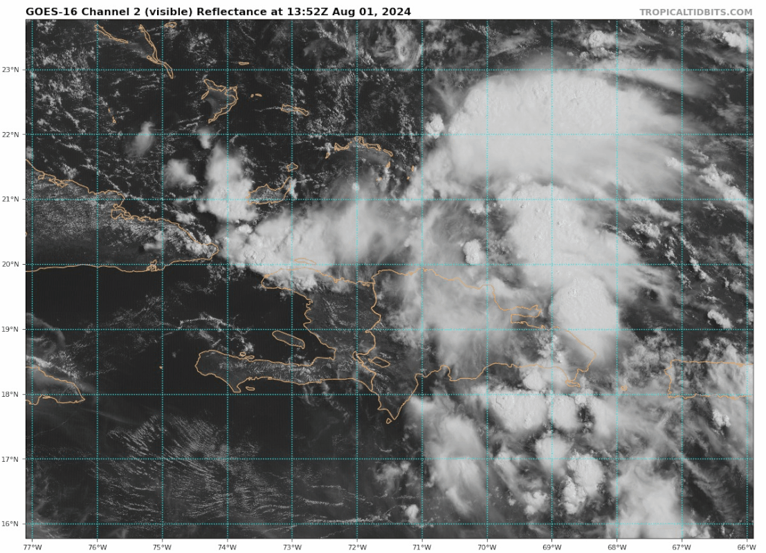
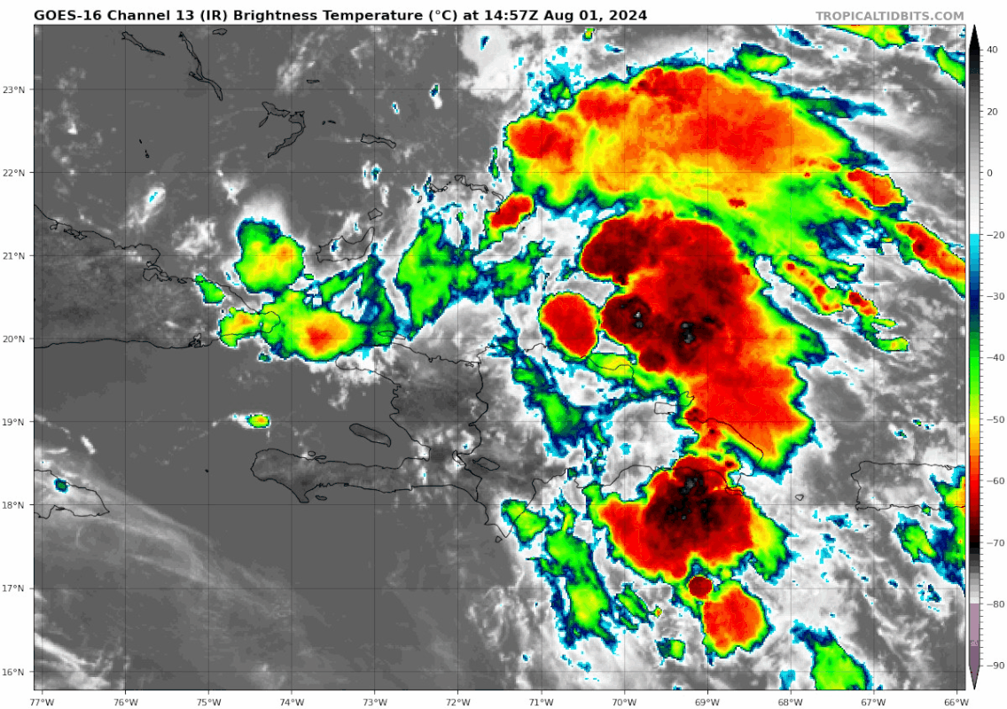
Seems to be some slight turning @20.5N/70.5W? I'm suspect the developing LLC is tracking down the Hispaniola Spine...
Last edited by Blown Away on Thu Aug 01, 2024 10:24 am, edited 1 time in total.
1 likes
Hurricane Eye Experience: David 79, Irene 99, Frances 04, Jeanne 04, Wilma 05… Hurricane Brush Experience: Andrew 92, Erin 95, Floyd 99, Matthew 16, Irma 17, Ian 22, Nicole 22…
-
cycloneye

- Admin

- Posts: 149598
- Age: 69
- Joined: Thu Oct 10, 2002 10:54 am
- Location: San Juan, Puerto Rico
Re: ATL: INVEST 97L - Discussion
If it stalls over this bathtube of very warm waters, yikes.

7 likes
Visit the Caribbean-Central America Weather Thread where you can find at first post web cams,radars
and observations from Caribbean basin members Click Here
and observations from Caribbean basin members Click Here
-
ScottNAtlanta

- Category 5

- Posts: 2535
- Joined: Sat May 25, 2013 3:11 pm
- Location: Atlanta, GA
Re: ATL: INVEST 97L - Discussion
Not only that, but the loop current is right there too, so it would not be suffering any upwelling if it stalls anywhere near there
0 likes
The posts in this forum are NOT official forecast and should not be used as such. They are just the opinion of the poster and may or may not be backed by sound meteorological data. They are NOT endorsed by any professional institution or storm2k.org. For official information, please refer to the NHC and NWS products.

Re: ATL: INVEST 97L - Discussion
https://i.postimg.cc/nzhd119m/c35572b6- ... 6548bb.gif
Seems to be some slight turning @20.5N/70.5W?[/quote]
Possibly? Like a slow closing off of the northern side of the broad Invest center over E. Dominican Republic? How many times have we seen that happen! That would change the game yet again
Seems to be some slight turning @20.5N/70.5W?[/quote]
Possibly? Like a slow closing off of the northern side of the broad Invest center over E. Dominican Republic? How many times have we seen that happen! That would change the game yet again
0 likes
Andy D
(For official information, please refer to the NHC and NWS products.)
(For official information, please refer to the NHC and NWS products.)
-
ElectricStorm

- Category 5
- Posts: 5148
- Age: 25
- Joined: Tue Aug 13, 2019 11:23 pm
- Location: Norman, OK
Re: ATL: INVEST 97L - Discussion
Feels like it depends where it ends up stalling out (assuming it does). If it goes more east over FL it might just be a TD/weak TS (but a huge flood threat if it stalls). But if it stalls over the gulf it could be a powerful hurricane.
Yeah not a fan of this one... At least it'll have to wait until after Cuba to get going
Yeah not a fan of this one... At least it'll have to wait until after Cuba to get going
1 likes
B.S Meteorology, University of Oklahoma '25
Please refer to the NHC, NWS, or SPC for official information.
Please refer to the NHC, NWS, or SPC for official information.
-
Stormlover70
- Tropical Storm

- Posts: 194
- Age: 56
- Joined: Fri Jun 21, 2024 5:31 am
- Location: New port richey
Re: ATL: INVEST 97L - Discussion
what can we expect in new port richey being on the dirty side? Thanks in advance.wxman57 wrote:Currently, it's just a wave of low pressure we're tracking. There is no "center". Models have come into better agreement that it will develop into a tropical storm west of Tampa in the eastern Gulf by Sunday afternoon. Looks like it may move inland just about where Idalia did last year Sunday night. It won't have a lot of time to organize, so it may not make it to hurricane intensity. However, we know that storms can strengthen very quickly under an ideal environment, so never say never. I don't see how one could say it will become a Cat 1 hurricane and not a Cat 2 or Cat 3. If something can become a hurricane, it can very quickly become a Cat 1 or 2. Looks like no weekend for me. We'll start advisories around this time tomorrow. I think NHC will follow suit tomorrow afternoon with PTC advisories. No depression until Sunday morning at the earliest.
0 likes

Re: ATL: INVEST 97L - Discussion
Large area of 6000 CAPE mid to east GOM.
This and a forecasted large anticyclone in the east GoM when the system is in the GoM, I would say the models are underestimating development.
This and a forecasted large anticyclone in the east GoM when the system is in the GoM, I would say the models are underestimating development.
1 likes

-
Hypercane_Kyle

- Category 5
- Posts: 3465
- Joined: Sat Mar 07, 2015 7:58 pm
- Location: Cape Canaveral, FL
Re: ATL: INVEST 97L - Discussion
Very high alert for this one. It's August (in a season that somehow already has managed to produce a Cat 5), moving into low shear and high moisture environment with a potential stall.
2 likes
My posts are my own personal opinion, defer to the National Hurricane Center (NHC) and other NOAA products for decision making during hurricane season.

Re: ATL: INVEST 97L - Discussion
GCANE wrote:Large area of 6000 CAPE mid to east GOM.
This and a forecasted large anticyclone in the east GoM when the system is in the GoM, I would say the models are underestimating development.
It depends if it stalls in the eastern GoM, because the GFS and some other global runs have shown it quickly crossing the Florida peninsula and stalling over the Gulf Stream just off the SEUS coast. Decent chance of a hurricane stalling very close to land, but it’s hard to tell which side of Florida it’ll be.
0 likes
Irene '11 Sandy '12 Hermine '16 5/15/2018 Derecho Fay '20 Isaias '20 Elsa '21 Henri '21 Ida '21
I am only a meteorology enthusiast who knows a decent amount about tropical cyclones. Look to the professional mets, the NHC, or your local weather office for the best information.
I am only a meteorology enthusiast who knows a decent amount about tropical cyclones. Look to the professional mets, the NHC, or your local weather office for the best information.
-
TomballEd
- Category 5
- Posts: 1306
- Age: 62
- Joined: Wed Aug 16, 2023 4:52 pm
- Location: Spring/Klein area, not Tomball
Re: ATL: INVEST 97L - Discussion
With ample convection N of Hispaniola, the low level max analyzed by CIMMS over the mountainous terrain of the DR, and the mid level max vorticity SE of the DR, S of the Mona Channel, it is too early to declare which model is most likely to verify. I'd exclude the clear outliers of the GFS and Euro ensembles, and anyplace else the ensembles show as a possible landfall. Predicting strength before the system is clear over water, which depends on where the dominant center forms, is foolish, so predicting intensity either side of Florida is not prudent.
0 likes
-
cycloneye
- Admin
- Posts: 149598
- Age: 69
- Joined: Thu Oct 10, 2002 10:54 am
- Location: San Juan, Puerto Rico
Re: ATL: INVEST 97L - Discussion
Hypercane_Kyle wrote:Very high alert for this one. It's August (in a season that somehow already has managed to produce a Cat 5), moving into low shear and high moisture environment with a potential stall.
Also will move to very warm waters in EGOM and if it gets to gulfstream.
0 likes
Visit the Caribbean-Central America Weather Thread where you can find at first post web cams,radars
and observations from Caribbean basin members Click Here
and observations from Caribbean basin members Click Here
-
wxman57

- Moderator-Pro Met

- Posts: 23175
- Age: 68
- Joined: Sat Jun 21, 2003 8:06 pm
- Location: Houston, TX (southwest)
Re: ATL: INVEST 97L - Discussion
MarioProtVI wrote:wxman57 wrote:Currently, it's just a wave of low pressure we're tracking. There is no "center". Models have come into better agreement that it will develop into a tropical storm west of Tampa in the eastern Gulf by Sunday afternoon. Looks like it may move inland just about where Idalia did last year Sunday night. It won't have a lot of time to organize, so it may not make it to hurricane intensity. However, we know that storms can strengthen very quickly under an ideal environment, so never say never. I don't see how one could say it will become a Cat 1 hurricane and not a Cat 2 or Cat 3. If something can become a hurricane, it can very quickly become a Cat 1 or 2. Looks like no weekend for me. We'll start advisories around this time tomorrow. I think NHC will follow suit tomorrow afternoon with PTC advisories. No depression until Sunday morning at the earliest.
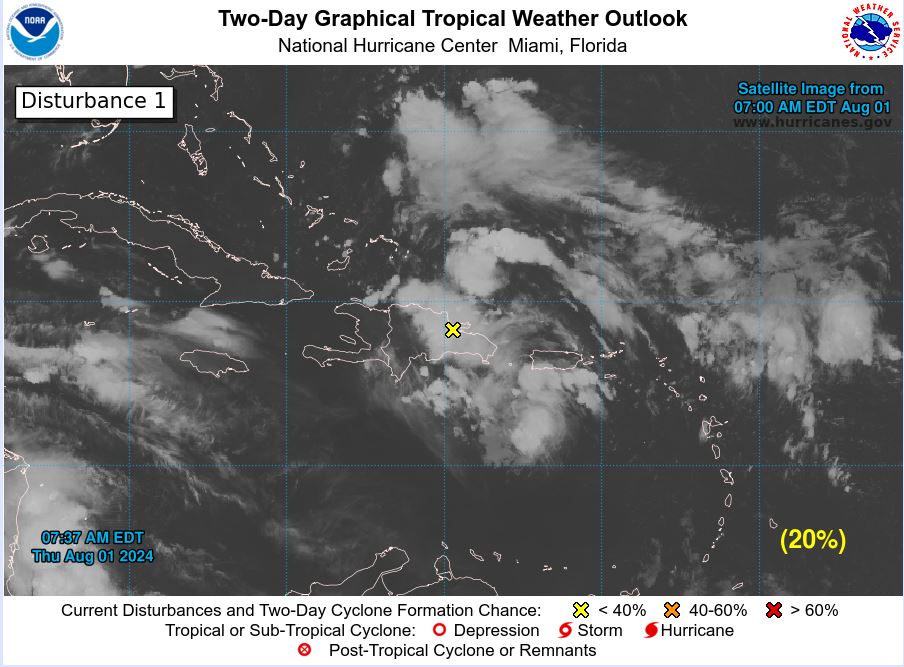
I don’t think NHC would start advisories that early. Probably not until Saturday when the 48hr chances are near 70%. Right now it’s only at 20/60 and likely to be 70/90 by Saturday at some point.
Looks like it may be a TS west of Tampa by 15Z Sunday, already producing TS wind not far offshore. That means 48 hour before then is 15z tomorrow. They will start PTC advisories tomorrow. Should be at 15Z tomorrow, but they may wait until 21Z.
1 likes
-
toad strangler

- S2K Supporter
- Posts: 4546
- Joined: Sun Jul 28, 2013 3:09 pm
- Location: Earth
- Contact:
Re: ATL: INVEST 97L - Discussion
Strengthening storms moving generally N along the W FL coast and strengthening have had a history of bending inland prematurely. I'm not insinuating anything. Just overly cautious. Will be interesting to see how quickly or not so quickly this wraps up after shedding the last of the big islands.
3 likes
My Weather Station
https://www.wunderground.com/dashboard/pws/KFLPORTS603
https://www.wunderground.com/dashboard/pws/KFLPORTS603
-
wxman57
- Moderator-Pro Met
- Posts: 23175
- Age: 68
- Joined: Sat Jun 21, 2003 8:06 pm
- Location: Houston, TX (southwest)
Re: ATL: INVEST 97L - Discussion
Stormlover70 wrote:what can we expect in new port richey being on the dirty side? Thanks in advance.wxman57 wrote:Currently, it's just a wave of low pressure we're tracking. There is no "center". Models have come into better agreement that it will develop into a tropical storm west of Tampa in the eastern Gulf by Sunday afternoon. Looks like it may move inland just about where Idalia did last year Sunday night. It won't have a lot of time to organize, so it may not make it to hurricane intensity. However, we know that storms can strengthen very quickly under an ideal environment, so never say never. I don't see how one could say it will become a Cat 1 hurricane and not a Cat 2 or Cat 3. If something can become a hurricane, it can very quickly become a Cat 1 or 2. Looks like no weekend for me. We'll start advisories around this time tomorrow. I think NHC will follow suit tomorrow afternoon with PTC advisories. No depression until Sunday morning at the earliest.
Currently, I have the sustained 39mph wind passing just to your west late Sunday morning. You'd see 25-35 mph sustained with gusts 40-50 mph and tides maybe 3-5 ft above normal. As a caveat, predicting wind structure on a disturbance predicted to become a TS is not an exact science. That, combined with the track uncertainty, leaves a good range of uncertainty as far as your winds.
3 likes
-
TampaWxLurker
- Tropical Storm
- Posts: 196
- Joined: Thu Aug 01, 2024 8:20 am
Re: ATL: INVEST 97L - Discussion
Long-time lurker (15+ years!), first-time poster.
Finally signed-up to say this storm, with its current location, trajectory and modelling with the expected stall remind this old-timer of Hurricane Elena '85. I hope I'm wrong.
Finally signed-up to say this storm, with its current location, trajectory and modelling with the expected stall remind this old-timer of Hurricane Elena '85. I hope I'm wrong.
6 likes

Re: ATL: INVEST 97L - Discussion
toad strangler wrote:Strengthening storms moving generally N along the W FL coast and strengthening have had a history of bending inland prematurely. I'm not insinuating anything. Just overly cautious. Will be interesting to see how quickly or not so quickly this wraps up after shedding the last of the big islands.
Yep, like Charley and Ian!
1 likes
Elena '85 - Charley '04 - Wilma '05 - Irma '17 - Ian '22
-
HurricaneBelle

- S2K Supporter
- Posts: 1209
- Joined: Sun Aug 27, 2006 6:12 pm
- Location: Clearwater, FL
Re: ATL: INVEST 97L - Discussion
beachnut wrote:toad strangler wrote:Strengthening storms moving generally N along the W FL coast and strengthening have had a history of bending inland prematurely. I'm not insinuating anything. Just overly cautious. Will be interesting to see how quickly or not so quickly this wraps up after shedding the last of the big islands.
Yep, like Charley and Ian!
On the other hand everyone was convinced Idalia was going to do likewise last year and she didn't. Every synoptic situation is different.
1 likes
Re: ATL: INVEST 97L - Discussion
Well, taking my last look at this system until later this evening and the only nuanced observation are the few arc clouds ejecting from some of the north side convection. That along with its persistent west forward motion and cut-off surface convergence from the south, I find myself leaning toward the southern vort max to eventually become the catalyst for organization. Whether this occurs at a latitude just south of Cuba or after traversing Cuba might too have ramifications reflecting how strong it might become in the GOM and timing of downstream track.
0 likes
Andy D
(For official information, please refer to the NHC and NWS products.)
(For official information, please refer to the NHC and NWS products.)
Who is online
Users browsing this forum: No registered users and 8 guests