Tropical Wave in SW Caribbean (0/0)
Moderator: S2k Moderators
Forum rules

The posts in this forum are NOT official forecasts and should not be used as such. They are just the opinion of the poster and may or may not be backed by sound meteorological data. They are NOT endorsed by any professional institution or STORM2K. For official information, please refer to products from the National Hurricane Center and National Weather Service.
-
LadyBug72

- Tropical Storm

- Posts: 121
- Joined: Mon Jun 01, 2020 3:39 pm
- Location: about 20 miles from Galveston, Tx
Re: Tropical Wave east of Windward Islands (10/30)
What do the steering currents look like for this wave in the future?
0 likes
Formerly known as the user: Nikki
Alicia 83, Allison 01, Rita 05, Ike 08, Harvey 17, Nicholas 21, Coastal Texas Derecho 24, Beryl 24
Alicia 83, Allison 01, Rita 05, Ike 08, Harvey 17, Nicholas 21, Coastal Texas Derecho 24, Beryl 24
-
Stratton23
- Category 5

- Posts: 3574
- Joined: Fri Jul 21, 2023 10:59 pm
- Location: Katy, Tx
Re: Tropical Wave east of Windward Islands (10/30)
Too early to say, but the gulf for sure will need to watch this one closely
2 likes
Re: Tropical Wave east of Windward Islands (10/30)
LadyBug72 wrote:What do the steering currents look like for this wave in the future?
Generally westward until the Western Caribbean. After that it is a bit too early to say but I think there are 3 main possibilities. Still way too early to know which scenario is most likely to happen though.
1. The wave doesn't develop and goes into Central America
2. The wave develops in the Western Caribbean but ridging is strong enough to maintain a westward to west-northwestward track into the Bay of Campeche and eventually Mexico
3. The wave develops in the Western Caribbean and there is a enough of a weakness over the CONUS to turn it more northwestward towards the Gulf Coast.
1 likes
-
TomballEd
- Category 5
- Posts: 1318
- Age: 62
- Joined: Wed Aug 16, 2023 4:52 pm
- Location: Spring/Klein area, not Tomball
Re: Tropical Wave east of Windward Islands (10/20)
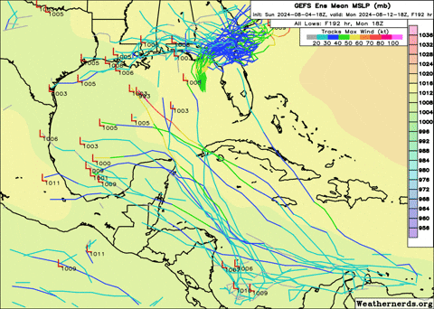
GEFS finally picking up on the NHC lemon.
1 likes
Re: Tropical Wave east of Windward Islands (10/30)
18Z EPS 25-30% of members show development

4 likes
Re: Tropical Wave east of Windward Islands (10/30)
Beryl cleanup is far from over here in the Houston area. This wave makes me nervous already.
5 likes
-
Stratton23
- Category 5
- Posts: 3574
- Joined: Fri Jul 21, 2023 10:59 pm
- Location: Katy, Tx
Re: Tropical Wave near the Windward Islands (10/30)
06z GFS with a weak Tropical Storm into eastern parts of houston
0 likes
-
Stratton23
- Category 5
- Posts: 3574
- Joined: Fri Jul 21, 2023 10:59 pm
- Location: Katy, Tx
Re: Tropical Wave near the Windward Islands (10/30)
Steering currents completely collapse on that run, GFS almost pulls a tropical storm allison
0 likes
-
cycloneye

- Admin

- Posts: 149703
- Age: 69
- Joined: Thu Oct 10, 2002 10:54 am
- Location: San Juan, Puerto Rico
Re: Tropical Wave near the Windward Islands (10/30)
Tropical Weather Outlook
NWS National Hurricane Center Miami FL
800 AM EDT Mon Aug 5 2024
For the North Atlantic...Caribbean Sea and the Gulf of Mexico:
Active Systems:
The National Hurricane Center is issuing advisories on Hurricane
Debby, centered inland near the Florida Big Bend.
1. East of the Windward Islands:
Showers and thunderstorms associated with a tropical wave located
near the Windward Islands have decreased and become less organized
since yesterday. Any development of this system should be slow to
occur during the next couple of days while the system moves westward
over the eastern Caribbean Sea. Environmental conditions are
expected to become more conducive for development later this week as
the system moves across the western Caribbean Sea or the southern
Gulf of Mexico.
* Formation chance through 48 hours...low...10 percent.
* Formation chance through 7 days...low...30 percent.
Forecaster D. Zelinsky
0 likes
Visit the Caribbean-Central America Weather Thread where you can find at first post web cams,radars
and observations from Caribbean basin members Click Here
and observations from Caribbean basin members Click Here

Re: Tropical Wave near the Windward Islands (10/30)
zzzh wrote:EPS keeps trending weaker.
What is EPS and I don't mean "earnings per share" as we are now seeing in the stock markets!
0 likes
-
toad strangler

- S2K Supporter

- Posts: 4546
- Joined: Sun Jul 28, 2013 3:09 pm
- Location: Earth
- Contact:
Re: Tropical Wave near the Windward Islands (10/30)
hipshot wrote:zzzh wrote:EPS keeps trending weaker.
What is EPS and I don't mean "earnings per share" as we are now seeing in the stock markets!
EPS are Euro ensembles
1 likes
My Weather Station
https://www.wunderground.com/dashboard/pws/KFLPORTS603
https://www.wunderground.com/dashboard/pws/KFLPORTS603
Re: Tropical Wave near the Windward Islands (10/30)
I'm more concerned about a little thing I see at 15N & 35W
Seems to already have some structure to it, and a good circulation.
Take a look here:
https://earth.nullschool.net/#current/w ... 696,15.346
Seems to already have some structure to it, and a good circulation.
Take a look here:
https://earth.nullschool.net/#current/w ... 696,15.346
0 likes
Cleo - 1964, Betsy - 1965, David - 1979, Andrew - 1992, Charlie (Francis, Ivan, Jeanne) - 2004, Irma - 2017, Ian - 2022, Milton - 2024
-
ConvergenceZone
.gif)
- Category 5
- Posts: 5241
- Joined: Fri Jul 29, 2005 1:40 am
- Location: Northern California
Re: Tropical Wave near the Windward Islands (10/30)
zzzh wrote:EPS keeps trending weaker.
Yea I don't think we will see too much action out of this wave. The NHC is even keeping development chances at 30% in the long term. We should start seeing some strong waves behind it though being that we will be approaching the middle of August soon.
0 likes
-
cycloneye
- Admin
- Posts: 149703
- Age: 69
- Joined: Thu Oct 10, 2002 10:54 am
- Location: San Juan, Puerto Rico
Re: Tropical Wave near the Windward Islands (10/30)
12z GFS develops in GOM.


1 likes
Visit the Caribbean-Central America Weather Thread where you can find at first post web cams,radars
and observations from Caribbean basin members Click Here
and observations from Caribbean basin members Click Here
-
Stormcenter
- S2K Supporter
- Posts: 6689
- Joined: Wed Sep 03, 2003 11:27 am
- Location: Houston, TX
Re: Tropical Wave near the Windward Islands (10/30)
Really…….it’s August.
ConvergenceZone wrote:zzzh wrote:EPS keeps trending weaker.
Yea I don't think we will see too much action out of this wave. The NHC is even keeping development chances at 30% in the long term. We should start seeing some strong waves behind it though being that we will be approaching the middle of August soon.
1 likes
-
cycloneye
- Admin
- Posts: 149703
- Age: 69
- Joined: Thu Oct 10, 2002 10:54 am
- Location: San Juan, Puerto Rico
Re: Tropical Wave near the Windward Islands (10/30)
12z GFS landfall just south of Galveston with 971 mb pressure.

0 likes
Visit the Caribbean-Central America Weather Thread where you can find at first post web cams,radars
and observations from Caribbean basin members Click Here
and observations from Caribbean basin members Click Here

Re: Tropical Wave near the Windward Islands (10/30)
12z GFS and CMC develop, with a northerly track on the former (NW into the Gulf, Harvey-esqe track) and a southern track on the latter (buries into Central America, attempts to emerge in BoC).
0 likes
Irene '11 Sandy '12 Hermine '16 5/15/2018 Derecho Fay '20 Isaias '20 Elsa '21 Henri '21 Ida '21
I am only a meteorology enthusiast who knows a decent amount about tropical cyclones. Look to the professional mets, the NHC, or your local weather office for the best information.
I am only a meteorology enthusiast who knows a decent amount about tropical cyclones. Look to the professional mets, the NHC, or your local weather office for the best information.
-
Stratton23
- Category 5
- Posts: 3574
- Joined: Fri Jul 21, 2023 10:59 pm
- Location: Katy, Tx
Re: Tropical Wave near the Windward Islands (10/30)
Im not buying the EPS/ Euro, given how the GFS has done a better job at seeing development this year than the euro, im leaning more towards development of the wave, looking in real time, the wave is also convectively active and more amplified currently than what the euro shows
0 likes
-
TomballEd
- Category 5
- Posts: 1318
- Age: 62
- Joined: Wed Aug 16, 2023 4:52 pm
- Location: Spring/Klein area, not Tomball
Re: Tropical Wave near the Windward Islands (10/30)
Stratton23 wrote:Im not buying the EPS/ Euro, given how the GFS has done a better job at seeing development this year than the euro, im leaning more towards development of the wave, looking in real time, the wave is also convectively active and more amplified currently than what the euro shows
The Euro ensembles had many members seeing Debby when the GFS had few, if any, for 2 or 3 days before the GEFS started catching on. 6Z GEFS, I think it was 3 of 30 seeing the wave entering the Caribbean reaching the W Gulf N of S. BoC Mexico.
3 likes
Who is online
Users browsing this forum: hurricanes1234, pepecool20 and 193 guests