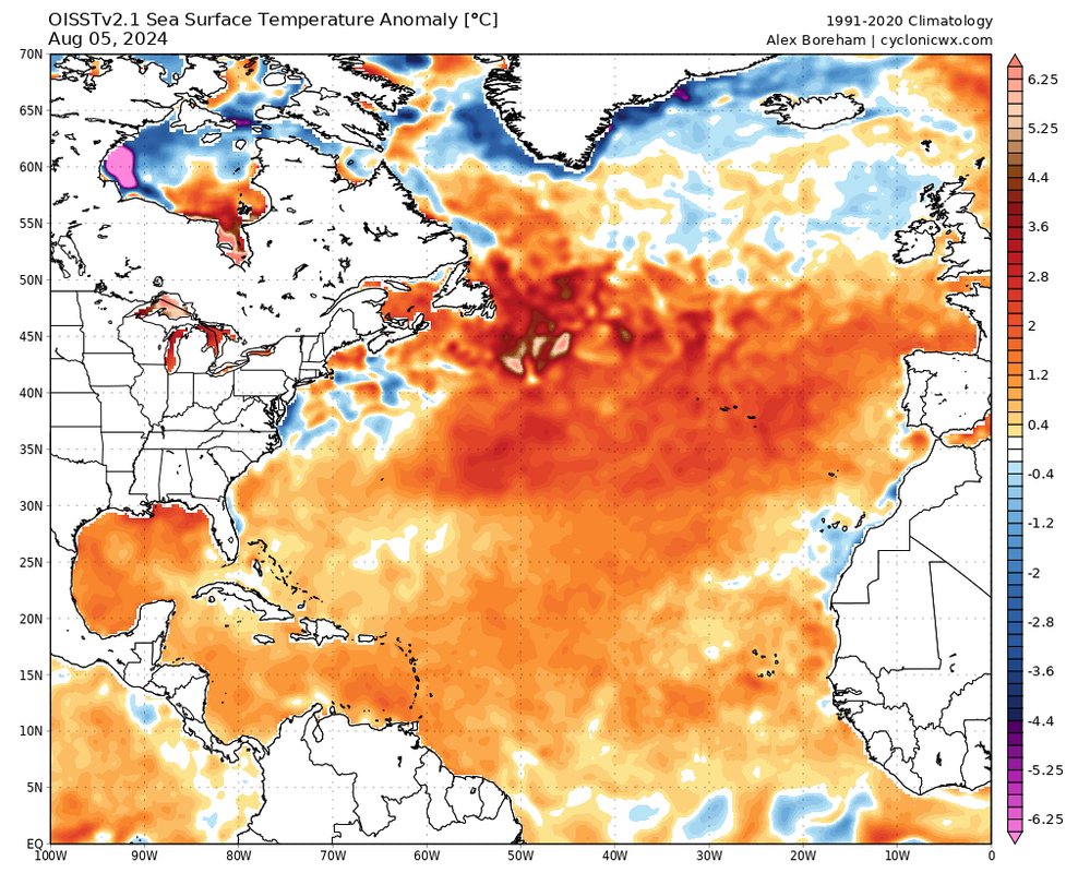
2024 Indicators: SST's, MSLP, Shear, SAL, Steering, Instability (Day 16+ Climate Models)

This is the general tropical discussion area. Anyone can take their shot at predicting a storms path.

Moderator: S2k Moderators

Forum rules

The posts in this forum are NOT official forecasts and should not be used as such. They are just the opinion of the poster and may or may not be backed by sound meteorological data. They are NOT endorsed by any professional institution or STORM2K. For official information, please refer to products from the National Hurricane Center and National Weather Service.

Help Support Storm2K
Message
Author
User avatar
ScottNAtlanta
Category 5
Category 5
Posts: 2367
Joined: Sat May 25, 2013 3:11 pm
Location: Atlanta, GA

Re: 2024 Indicators: SST's, MSLP, Shear, SAL, Steering, Instability (Day 16+ Climate Models)

#1701 Postby ScottNAtlanta » Mon Aug 05, 2024 2:15 pm

toad strangler wrote:
weeniepatrol wrote:By the way, Atlantic ACE STILL exceeds EPAC + WPAC combined


What really opens my eyes is that when you see such a BUSY EPAC the Atlantic should be dead. For the most part. To see this is worrisome.

https://i.ibb.co/DVb6NrK/Image-003.jpg

While there are a lot of storms, they have all been pretty low quality in the EPAC with only Carlotta briefly being a hurricane.
1 likes   
The posts in this forum are NOT official forecast and should not be used as such. They are just the opinion of the poster and may or may not be backed by sound meteorological data. They are NOT endorsed by any professional institution or storm2k.org. For official information, please refer to the NHC and NWS products.

User avatar
weeniepatrol
Category 5
Category 5
Posts: 1273
Joined: Sat Aug 22, 2020 5:30 pm
Location: WA State

Re: 2024 Indicators: SST's, MSLP, Shear, SAL, Steering, Instability (Day 16+ Climate Models)

#1702 Postby weeniepatrol » Mon Aug 05, 2024 2:19 pm

weeniepatrol wrote:By the way, Atlantic ACE STILL exceeds EPAC + WPAC combined


Image

Never seen anything like this before. I didn't even know this was possible!!!
3 likes   

User avatar
chaser1
S2K Supporter
S2K Supporter
Posts: 5464
Age: 64
Joined: Sat Oct 15, 2005 5:59 pm
Location: Longwood, Fl

Re: 2024 Indicators: SST's, MSLP, Shear, SAL, Steering, Instability (Day 16+ Climate Models)

#1703 Postby chaser1 » Mon Aug 05, 2024 2:32 pm

toad strangler wrote:
weeniepatrol wrote:By the way, Atlantic ACE STILL exceeds EPAC + WPAC combined


What really opens my eyes is that when you see such a BUSY EPAC the Atlantic should be dead. For the most part. To see this is worrisome.

https://i.ibb.co/DVb6NrK/Image-003.jpg


I agree. Furthermore, I think that once the real switch is flipped, we'll go back to seeing the lower latitude genesis that Beryl and Chris tipped off likely to be the predominate origin and potentially long range tracks. Sure, there will be a few recurves and probably a (smaller) number of outside-MDR development, but this seems like the year where "the swarm of bees" is not something way to the east but instead in our neck of the woods. My biggest question is how many will remain to the south to impact Central America & Mexico and how many will threaten the Greater Antilles and U.S? I'm sure it'll be excessive for both.
4 likes   
Andy D

(For official information, please refer to the NHC and NWS products.)

User avatar
weeniepatrol
Category 5
Category 5
Posts: 1273
Joined: Sat Aug 22, 2020 5:30 pm
Location: WA State

Re: 2024 Indicators: SST's, MSLP, Shear, SAL, Steering, Instability (Day 16+ Climate Models)

#1704 Postby weeniepatrol » Mon Aug 05, 2024 2:35 pm

chaser1 wrote:
toad strangler wrote:
weeniepatrol wrote:By the way, Atlantic ACE STILL exceeds EPAC + WPAC combined


What really opens my eyes is that when you see such a BUSY EPAC the Atlantic should be dead. For the most part. To see this is worrisome.

https://i.ibb.co/DVb6NrK/Image-003.jpg


I agree. Furthermore, I think that once the real switch is flipped, we'll go back to seeing the lower latitude genesis that Beryl and Chris tipped off likely to be the predominate origin and potentially long range tracks. Sure, there will be a few recurves and probably a (smaller) number of outside-MDR development, but this seems like the year where "the swarm of bees" is not something way to the east but instead in our neck of the woods. My biggest question is how many will remain to the south to impact Central America & Mexico and how many will threaten the Greater Antilles and U.S? I'm sure it'll be excessive for both.


Even Debby formed below the Tropic of Cancer. Every single system has been pure tropical energy forming in the deep tropics, then hitting land.

This season is already extremely uncomfortable.
6 likes   

User avatar
weeniepatrol
Category 5
Category 5
Posts: 1273
Joined: Sat Aug 22, 2020 5:30 pm
Location: WA State

Re: 2024 Indicators: SST's, MSLP, Shear, SAL, Steering, Instability (Day 16+ Climate Models)

#1705 Postby weeniepatrol » Mon Aug 05, 2024 2:39 pm

BTW, here's a daily ACE plot, showing average ACE per day through the season. Credit to Deelan Jariwala.

Image

As you can see, early August is just a glorified late July. Extremely inactive.. even mid July has more activity. Oh, also the MJO is located directly over the EPAC which has like four active systems, and suppressed intraseasonal forcing remains over the Atlantic.

So lets see; we've got suppressed MJO, EPAC "outbreak", and awful climatology and we STILL get a US hurricane landfall in Debby, oh and btw it's going to meander and dump 20-30 inches of rain on multiple US cities.

I'm waving a white flag. Let us fast travel to November, please.
15 likes   

User avatar
cycloneye
Admin
Admin
Posts: 145299
Age: 68
Joined: Thu Oct 10, 2002 10:54 am
Location: San Juan, Puerto Rico

Re: 2024 Indicators: SST's, MSLP, Shear, SAL, Steering, Instability (Day 16+ Climate Models)

#1706 Postby cycloneye » Mon Aug 05, 2024 3:46 pm

cycloneye wrote:
zzzh wrote:EC seasonal predicts 1.5x climo ace for SONDJF


You may have to explain a little more and if there are graphics better, as many members may not understand that.


Found graphics from ECMWF and what it means for the rest of season.

 https://x.com/Souza101Matt/status/1820554906404782562

0 likes   
Visit the Caribbean-Central America Weather Thread where you can find at first post web cams,radars
and observations from Caribbean basin members Click Here

User avatar
chaser1
S2K Supporter
S2K Supporter
Posts: 5464
Age: 64
Joined: Sat Oct 15, 2005 5:59 pm
Location: Longwood, Fl

Re: 2024 Indicators: SST's, MSLP, Shear, SAL, Steering, Instability (Day 16+ Climate Models)

#1707 Postby chaser1 » Tue Aug 06, 2024 2:05 am

Another interestingly LARGE easterly surge similar to what spawned Debby can be seen on satellite at about 15N and 40W. It too is barreling westward without any hint of convection, but I wonder if it too will slowly draw moisture as it approached the Lesser Antilles? I suppose that might be more dependent on downstream upper-level conditions. Seems like the Atlantic is still shaking out a bit of African dust.
2 likes   
Andy D

(For official information, please refer to the NHC and NWS products.)

User avatar
cycloneye
Admin
Admin
Posts: 145299
Age: 68
Joined: Thu Oct 10, 2002 10:54 am
Location: San Juan, Puerto Rico

Re: 2024 Indicators: SST's, MSLP, Shear, SAL, Steering, Instability (Day 16+ Climate Models)

#1708 Postby cycloneye » Tue Aug 06, 2024 8:26 am

0 likes   
Visit the Caribbean-Central America Weather Thread where you can find at first post web cams,radars
and observations from Caribbean basin members Click Here

MarioProtVI
Category 4
Category 4
Posts: 935
Age: 24
Joined: Sun Sep 29, 2019 7:33 pm
Location: New Jersey

Re: 2024 Indicators: SST's, MSLP, Shear, SAL, Steering, Instability (Day 16+ Climate Models)

#1709 Postby MarioProtVI » Tue Aug 06, 2024 3:51 pm

CHI forecasts from the models from end of August to mid-September don’t scream hyperactive moreso just a semi-active period. Might just be me but idk. Would peak season override it and we end up like 2017 which I think was similar with a +CHI anomaly over the Atlantic but still went crazy?
1 likes   

Stratton23
Category 5
Category 5
Posts: 2519
Joined: Fri Jul 21, 2023 10:59 pm
Location: Katy, Tx

Re: 2024 Indicators: SST's, MSLP, Shear, SAL, Steering, Instability (Day 16+ Climate Models)

#1710 Postby Stratton23 » Tue Aug 06, 2024 3:59 pm

NOAA has a highlighted zone for possible development in the western- NW gulf from august 14th-20th, im not seeing anything in model guidance in that time frame, any pro mets here maybe know what that agency is seeing to pit that out on the tropical hazards outlook?
1 likes   

User avatar
MetroMike
Category 4
Category 4
Posts: 952
Joined: Sun Aug 29, 2004 8:13 pm
Location: Tampa Bay
Contact:

Re: 2024 Indicators: SST's, MSLP, Shear, SAL, Steering, Instability (Day 16+ Climate Models)

#1711 Postby MetroMike » Tue Aug 06, 2024 4:07 pm

Getting into the heart of the season Image
2 likes   

User avatar
hurricanetrack
HurricaneTrack.com
HurricaneTrack.com
Posts: 1781
Joined: Tue Dec 02, 2003 10:46 pm
Location: Wilmington, NC
Contact:

Re: 2024 Indicators: SST's, MSLP, Shear, SAL, Steering, Instability (Day 16+ Climate Models)

#1712 Postby hurricanetrack » Tue Aug 06, 2024 5:00 pm

Figured I would drop today's video in this thread. We all "know" what's likely coming...Debby and Beryl before that seem to be telling us that CSU is on track. Hope everyone is extra ready!!!

https://www.youtube.com/watch?v=Wby7Eb0KSy8
12 likes   

User avatar
Ubuntwo
Category 5
Category 5
Posts: 1406
Age: 31
Joined: Thu Oct 05, 2017 10:41 pm

Re: 2024 Indicators: SST's, MSLP, Shear, SAL, Steering, Instability (Day 16+ Climate Models)

#1713 Postby Ubuntwo » Tue Aug 06, 2024 6:22 pm

MarioProtVI wrote:CHI forecasts from the models from end of August to mid-September don’t scream hyperactive moreso just a semi-active period. Might just be me but idk. Would peak season override it and we end up like 2017 which I think was similar with a +CHI anomaly over the Atlantic but still went crazy?

+CHI over the Atlantic and -CHI over Africa and the Indian Ocean is the most favorable possible look for north Atlantic activity. See 2020’s setup. This is MJO phases 2-3 verbatim.
1 likes   
Kendall -> SLO -> PBC

Memorable Storms: Katrina (for its Florida landfall...) Wilma Matthew Irma

User avatar
WaveBreaking
Category 2
Category 2
Posts: 578
Joined: Sun Jun 30, 2024 11:33 am
Location: US

Re: 2024 Indicators: SST's, MSLP, Shear, SAL, Steering, Instability (Day 16+ Climate Models)

#1714 Postby WaveBreaking » Tue Aug 06, 2024 7:46 pm

Seeing how debby managed to form during an (albeit quantity>quality) EPAC outbreak and an unfavorable MJO phase, I wouldn't be surprised if we see 1995-levels of CV activity once the switch inevitably flips
Image
5 likes   
I am NOT a professional meteorologist, so take all of my posts with a grain of salt. My opinions are mine and mine alone.

User avatar
SFLcane
S2K Supporter
S2K Supporter
Posts: 10163
Age: 47
Joined: Sat Jun 05, 2010 1:44 pm
Location: Lake Worth Florida

Re: 2024 Indicators: SST's, MSLP, Shear, SAL, Steering, Instability (Day 16+ Climate Models)

#1715 Postby SFLcane » Tue Aug 06, 2024 9:00 pm

.
Last edited by SFLcane on Wed Aug 07, 2024 4:18 am, edited 1 time in total.
0 likes   

Stratton23
Category 5
Category 5
Posts: 2519
Joined: Fri Jul 21, 2023 10:59 pm
Location: Katy, Tx

Re: 2024 Indicators: SST's, MSLP, Shear, SAL, Steering, Instability (Day 16+ Climate Models)

#1716 Postby Stratton23 » Tue Aug 06, 2024 9:26 pm

I think its a really bad thing thats its quiet like now, because thats just allowing for OHC to continue to build in the western caribbean and even in the gulf, water temps have already begun to rebound from debbie, unfortunately with all of that available energy, i fear things could potentially get ugly once that MJO establishes itself in the atlantic and the dust begins a non factor
4 likes   

User avatar
Teban54
Category 5
Category 5
Posts: 3204
Joined: Sat May 19, 2018 1:19 pm

Re: 2024 Indicators: SST's, MSLP, Shear, SAL, Steering, Instability (Day 16+ Climate Models)

#1717 Postby Teban54 » Tue Aug 06, 2024 11:00 pm

Not sure how sensitive OISST is to SAL outbreaks (IIRC it's better than CDAS but still somewhat affected), but it indicates some cooling of the Atlantic MDR recently, though still well-above average. The subtropics is also anomalously warm and seems to have been warming slightly, more notably to the west.

Image

Image

However, upcoming westerlies should warm up the MDR again:
Image
2 likes   

LarryWx
S2K Supporter
S2K Supporter
Posts: 6305
Joined: Sun Sep 07, 2003 2:04 pm
Location: GA

Re: 2024 Indicators: SST's, MSLP, Shear, SAL, Steering, Instability (Day 16+ Climate Models)

#1718 Postby LarryWx » Wed Aug 07, 2024 1:11 am

2024 has had 2 CONUS H landfalls by Aug 5th. Since 1851, there have been only 8 other seasons with 2+ by then with 7 of those 8 having exactly 2:

Year: # of CONUS H LFs by 8/5; # for 8/6+; *ASO ENSO ONI

-2024: 2; ?; ?
-2020: 2; 4; -1.2
-2005: 2; 3; -0.0
-1959: 2; 1; -0.3
-1936: 2; 1; -0.3
-1934: 2; 1; -0.1
-1916: 2; 2; -1.4
-1909: 2; 3; -1.0
-1886: 4; 2; -0.8

-So, only one season (1886) since 1851 has had more CONUS H landfalls by 8/5 than 2024
-All 8 seasons had at least one 8/6+ CONUS H landfall with a range of 1-4 and an average of 2.1
-The 5 seasons with 2-4 8/6+ CONUS H landfalls (avg of 3) had an average -0.9 in ASO
-The 3 seasons with only one 8/6+ H landfall averaged -0.2 in ASO
-Most likely the 2024 ASO RONI will be much closer to -0.8 than to -0.2, which implies we may be headed to ~3 more CONUS H landfalls this season for a rare total of ~5, a scary thought; only 1886, 1893, 1985, 2004, 2005, and 2020 had 5+ (5-6)

*ASO: used RONI for 1950+ and Webb ONI pre 1950
5 likes   
Personal Forecast Disclaimer:
The posts in this forum are NOT official forecasts and should not be used as such. They are just the opinion of the poster and may or may not be backed by sound meteorological data. They are NOT endorsed by any professional institution or storm2k.org. For official information, please refer to the NHC and NWS products.

User avatar
cycloneye
Admin
Admin
Posts: 145299
Age: 68
Joined: Thu Oct 10, 2002 10:54 am
Location: San Juan, Puerto Rico

Re: 2024 Indicators: SST's, MSLP, Shear, SAL, Steering, Instability (Day 16+ Climate Models)

#1719 Postby cycloneye » Wed Aug 07, 2024 10:04 pm

1 likes   
Visit the Caribbean-Central America Weather Thread where you can find at first post web cams,radars
and observations from Caribbean basin members Click Here

User avatar
weeniepatrol
Category 5
Category 5
Posts: 1273
Joined: Sat Aug 22, 2020 5:30 pm
Location: WA State

Re: 2024 Indicators: SST's, MSLP, Shear, SAL, Steering, Instability (Day 16+ Climate Models)

#1720 Postby weeniepatrol » Wed Aug 07, 2024 10:54 pm

NHC surface analysis shows MDR surface pressures have fallen below 1012mb. Been 1014-1016 for many weeks; lowest MDR pressures of the season.

Image
1 likes   


Return to “Talkin' Tropics”

Who is online

Users browsing this forum: kevin, Ulf and 20 guests