Tropical Wave in Eastern Atlantic (Is Invest 98L)
Moderator: S2k Moderators
Forum rules

The posts in this forum are NOT official forecasts and should not be used as such. They are just the opinion of the poster and may or may not be backed by sound meteorological data. They are NOT endorsed by any professional institution or STORM2K. For official information, please refer to products from the National Hurricane Center and National Weather Service.
Re: Tropical Wave in Eastern Atlantic (0/50)
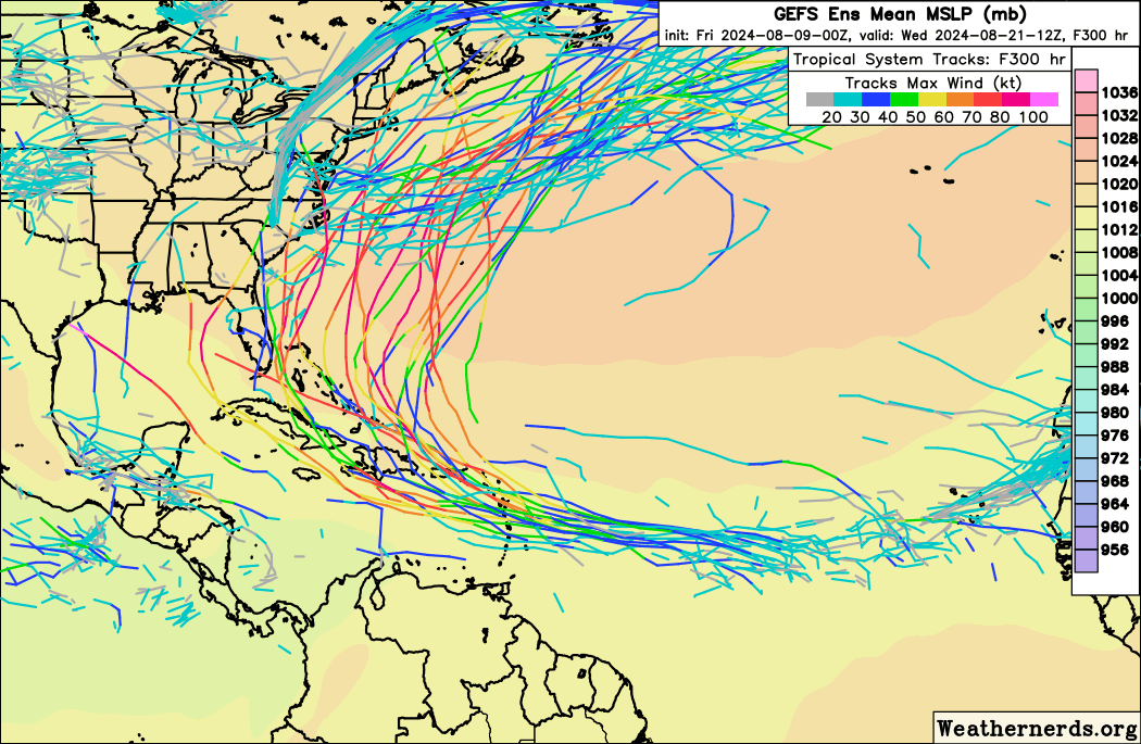
0Z EPS mean is E of the more threatening GEFS with very few in the Gulf and most members recurving E of the US. A nontrivial number still hit the E coast, however. So, a long way to go!
0 likes
Personal Forecast Disclaimer:
The posts in this forum are NOT official forecasts and should not be used as such. They are just the opinion of the poster and may or may not be backed by sound meteorological data. They are NOT endorsed by any professional institution or storm2k.org. For official information, please refer to the NHC and NWS products.
The posts in this forum are NOT official forecasts and should not be used as such. They are just the opinion of the poster and may or may not be backed by sound meteorological data. They are NOT endorsed by any professional institution or storm2k.org. For official information, please refer to the NHC and NWS products.
-
lilbump3000

- Category 4

- Posts: 966
- Age: 38
- Joined: Sat Sep 20, 2003 10:09 am
- Location: New Orleans, Louisiana
- Contact:


Re: Tropical Wave in Eastern Atlantic (0/50)
A couple of GEFS members do look very concerning. But shoutout to that one member with Idalia 2.0 giving Perry its 3rd hurricane in 2 years 
Meanwhile, 0z Euro looks like it's aiming for that rare Maine landfall:
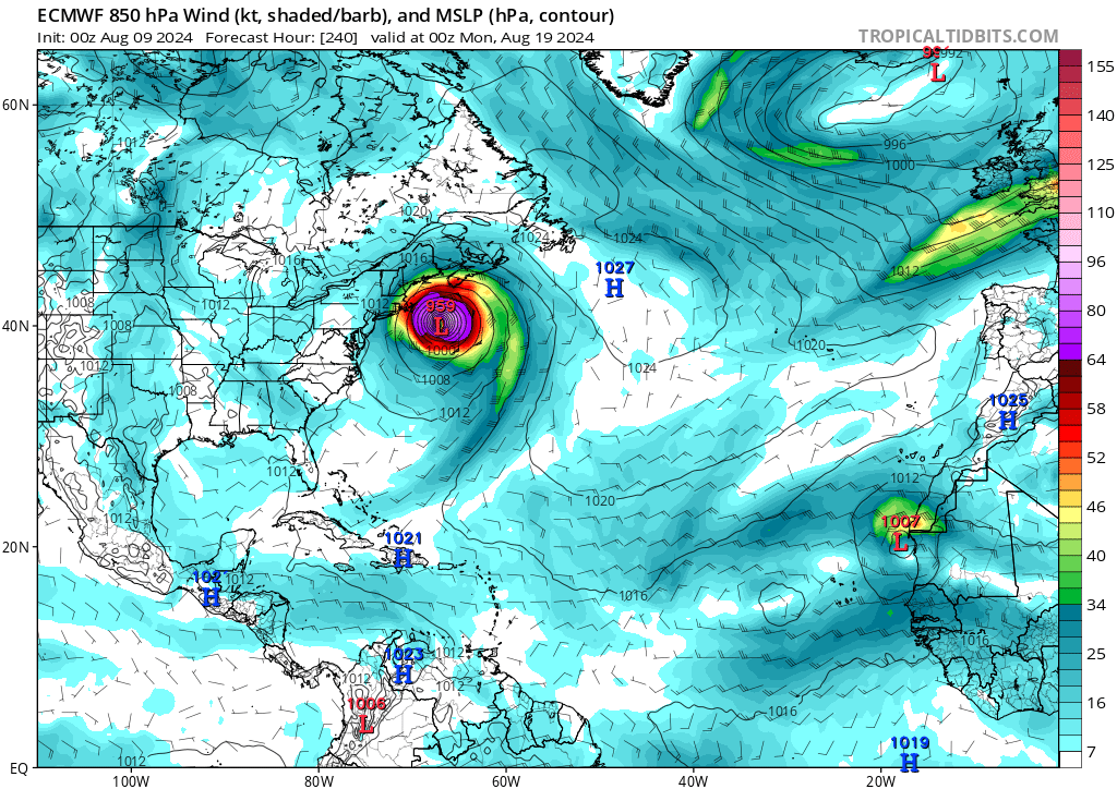
Meanwhile, 0z Euro looks like it's aiming for that rare Maine landfall:
0 likes
TC naming lists: retirements and intensity
Most aggressive Advisory #1's in North Atlantic (cr. kevin for starting the list)
Most aggressive Advisory #1's in North Atlantic (cr. kevin for starting the list)

-
Hurricane2022

- Category 5

- Posts: 2092
- Joined: Tue Aug 23, 2022 11:38 pm
- Location: Araçatuba, Brazil
Re: Tropical Wave in Eastern Atlantic (0/50)
mantis83 wrote:I smell a fish, and the models do too!…….
I still don't know if you do it as a joke or to annoy. Please stop this.
The world is not a US territory...
18 likes
Sorry for the bad English sometimes...!
For reliable and detailed information for any meteorological phenomenon, please consult the National Hurricane Center, Joint Typhoon Warning Center , or your local Meteo Center.
--------
ECCE OMNIA NOVA FACIAM (Ap 21,5).
For reliable and detailed information for any meteorological phenomenon, please consult the National Hurricane Center, Joint Typhoon Warning Center , or your local Meteo Center.
--------
ECCE OMNIA NOVA FACIAM (Ap 21,5).
-
jlauderdal
- S2K Supporter

- Posts: 7240
- Joined: Wed May 19, 2004 5:46 am
- Location: NE Fort Lauderdale
- Contact:
Re: Tropical Wave in Eastern Atlantic (0/50)
Hurricane2022 wrote:mantis83 wrote:I smell a fish, and the models do too!…….
I still don't know if you do it as a joke or to annoy. Please stop this.
The world is not a US territory...
I sent mantis a dm to help him with terminology and a few "suggestions". Too early to call this a fish, more concerning now is what else is on the map, as we inch closer to peak.
7 likes
-
otowntiger
- Category 5
- Posts: 1932
- Joined: Tue Aug 31, 2004 7:06 pm
Re: Tropical Wave in Eastern Atlantic (0/50)
well said. But what else is on the map at this time?jlauderdal wrote:Hurricane2022 wrote:mantis83 wrote:I smell a fish, and the models do too!…….
I still don't know if you do it as a joke or to annoy. Please stop this.
The world is not a US territory...
I sent mantis a dm to help him with terminology and a few "suggestions". Too early to call this a fish, more concerning now is what else is on the map, as we inch closer to peak.
0 likes
-
jlauderdal
- S2K Supporter
- Posts: 7240
- Joined: Wed May 19, 2004 5:46 am
- Location: NE Fort Lauderdale
- Contact:
Re: Tropical Wave in Eastern Atlantic (0/50)
otowntiger wrote:well said. But what else is on the map at this time?jlauderdal wrote:Hurricane2022 wrote:I still don't know if you do it as a joke or to annoy. Please stop this.
The world is not a US territory...
I sent mantis a dm to help him with terminology and a few "suggestions". Too early to call this a fish, more concerning now is what else is on the map, as we inch closer to peak.
Model Maps have activity in the longer range, I could have been more clear about which maps.
0 likes
-
Hurricaneman

- Category 5
- Posts: 7404
- Age: 45
- Joined: Tue Aug 31, 2004 3:24 pm
- Location: central florida
-
AubreyStorm

- Category 1

- Posts: 337
- Age: 45
- Joined: Fri Jun 16, 2017 6:21 pm
- Location: Texas, USA
Re: Tropical Wave in Eastern Atlantic (0/50)
Hurricaneman wrote:The 6zGFS shows a cat 3 impact to OBX this run
OBX? Means??
0 likes
The posts are NOT an official forecast. Please REFER to the NHC and NWS for official forecasts and products.
-
Hurricaneman
- Category 5
- Posts: 7404
- Age: 45
- Joined: Tue Aug 31, 2004 3:24 pm
- Location: central florida
Re: Tropical Wave in Eastern Atlantic (0/50)
AubreyStorm wrote:Hurricaneman wrote:The 6zGFS shows a cat 3 impact to OBX this run
OBX? Means??
Cape Hatteras, NC
1 likes
Re: Tropical Wave in Eastern Atlantic (0/50)
Hurricaneman wrote:The 6zGFS shows a cat 3 impact to OBX this run
Much stronger subtropical ridge
0 likes
Re: Tropical Wave in Eastern Atlantic (0/50)
AubreyStorm wrote:Hurricaneman wrote:The 6zGFS shows a cat 3 impact to OBX this run
OBX? Means??
North Carolina Outer Banks
4 likes
-
jlauderdal
- S2K Supporter
- Posts: 7240
- Joined: Wed May 19, 2004 5:46 am
- Location: NE Fort Lauderdale
- Contact:
Re: Tropical Wave in Eastern Atlantic (0/50)
Hurricaneman wrote:AubreyStorm wrote:Hurricaneman wrote:The 6zGFS shows a cat 3 impact to OBX this run
OBX? Means??
Cape Hatteras, NC
Outer Banks, Cape Hatteras is on the outer banks, but that's not what OBX means. SOFLA means lots of things, which is why I say SEFL. In terms of this board, there is a big difference between SWFL and SEFL-ask the recipients of IAN and IRMA, but both are in SOFLA.
2 likes
-
Weathertracker96
- Tropical Storm

- Posts: 150
- Joined: Mon Oct 16, 2023 3:41 pm
Re: Tropical Wave in Eastern Atlantic (0/50)
That surely was a shift west. I don’t know if the gfs had it this close to the coast before. Surely no fish as of now because models already have it hitting the islands. It’s still early and until we get a center and more data, don’t be surprised to see more changes.
0 likes

Re: Tropical Wave in Eastern Atlantic (0/60)
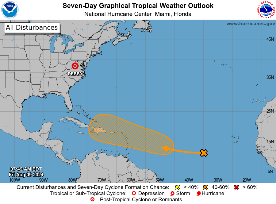
Tropical Weather Outlook
NWS National Hurricane Center Miami FL
800 AM EDT Fri Aug 9 2024
For the North Atlantic...Caribbean Sea and the Gulf of Mexico:
Active Systems:
The Weather Prediction Center is issuing advisories on Post-Tropical
Cyclone Debby, located inland over the Mid-Atlantic region.
Near the Lesser and Greater Antilles:
A tropical wave located several hundred miles to the west-southwest
of the Cabo Verde Islands is producing a large area of disorganized
showers and thunderstorms over the tropical Atlantic. Any
development of the wave should be slow to occur during the next
couple of days while it moves westward across the central tropical
Atlantic. Afterwards, conditions are expected to become more
conducive for development while the wave moves west-northwestward,
and a tropical depression could form by early next week while the
system approaches the Lesser Antilles. The system is then forecast
to continue moving generally west-northwestward and could approach
the Greater Antilles by the middle part of next week.
* Formation chance through 48 hours...low...near 0 percent.
* Formation chance through 7 days...medium...60 percent.
$$
Forecaster Reinhart
Last edited by abajan on Fri Aug 09, 2024 7:04 am, edited 1 time in total.
0 likes
-
jlauderdal
- S2K Supporter
- Posts: 7240
- Joined: Wed May 19, 2004 5:46 am
- Location: NE Fort Lauderdale
- Contact:
Re: Tropical Wave in Eastern Atlantic (0/50)
jlauderdal wrote:Hurricaneman wrote:AubreyStorm wrote:
OBX? Means??
Cape Hatteras, NC
Outer Banks, Cape Hatteras is on the outer banks, but that's not what OBX means. SOFLA means lots of things, which is why I say SEFL. In terms of this board, there is a big difference between SWFL and SEFL-ask the recipients of IAN and IRMA, but both are in SOFLA.
Last geo post for today and this includes govt agencies like NHC. When you say all interests in Florida or its nearing Florida, you are causing confusion. There is a big difference between something closing in on Miami and something closing in on Pensacola for the general public not watching every model cycle.
0 likes
-
AutoPenalti
- Category 5
- Posts: 4091
- Age: 29
- Joined: Mon Aug 17, 2015 4:16 pm
- Location: Ft. Lauderdale, Florida
Re: Tropical Wave in Eastern Atlantic (0/60)
It’s a complex set up, if it hasn’t been yet, it’s going to be.
0 likes
The posts in this forum are NOT official forecasts and should not be used as such. They are just the opinion of the poster and may or may not be backed by sound meteorological data. They are NOT endorsed by any professional institution or STORM2K. For official information, please refer to products from the NHC and NWS.
Model Runs Cheat Sheet:
GFS (5:30 AM/PM, 11:30 AM/PM)
HWRF, GFDL, UKMET, NAVGEM (6:30-8:00 AM/PM, 12:30-2:00 AM/PM)
ECMWF (1:45 AM/PM)
TCVN is a weighted averaged
-
Category5Kaiju

- Category 5
- Posts: 4345
- Joined: Thu Dec 24, 2020 12:45 pm
- Location: Seattle during the summer, Phoenix during the winter
Re: Tropical Wave in Eastern Atlantic (0/60)
The wave already looks very healthy on satellite. Almost looks like the budding of a monstrous storm. Where it goes...that's the big question isn't it? And no, I don't count this as a "fish" storm because it seems on track to impact the extreme northeastern Caribbean islands.
2 likes
Unless explicitly stated, all information in my posts is based on my own opinions and observations. Tropical storms and hurricanes can be extremely dangerous. Refer to an accredited weather research agency or meteorologist if you need to make serious decisions regarding an approaching storm.

Re: Tropical Wave in Eastern Atlantic (0/60)
Will be interesting to see how the EC and GFS emsembles trend the next few days. Way too early to know where this storm goes past the LAs. All we have to do is remember the early runs of Debby. The Euro consistently had it going up the east coast.
2 likes
Who is online
Users browsing this forum: No registered users and 203 guests