RIP Leafs and Eskimo's
Tropical Wave in Eastern Atlantic (Is Invest 98L)
Moderator: S2k Moderators
Forum rules

The posts in this forum are NOT official forecasts and should not be used as such. They are just the opinion of the poster and may or may not be backed by sound meteorological data. They are NOT endorsed by any professional institution or STORM2K. For official information, please refer to products from the National Hurricane Center and National Weather Service.
-
BIFF_THE_UNRULY
- Tropical Storm

- Posts: 143
- Joined: Fri Jun 28, 2024 2:12 pm
-
toad strangler

- S2K Supporter

- Posts: 4546
- Joined: Sun Jul 28, 2013 3:09 pm
- Location: Earth
- Contact:
Re: Tropical Wave in Eastern Atlantic (0/60)
aspen wrote:
Look at that one ensemble member has a Cat 1/2 hit in the NYC area. Thankfully it’s an outlier for now.
I rarely opine on individual ensemble members but that same member you cite equally threatens WPB FL, Cape Hatteras NC, and the NJ shore before approaching the NYC area.
0 likes
My Weather Station
https://www.wunderground.com/dashboard/pws/KFLPORTS603
https://www.wunderground.com/dashboard/pws/KFLPORTS603
-
Hurricane2022

- Category 5

- Posts: 2092
- Joined: Tue Aug 23, 2022 11:38 pm
- Location: Araçatuba, Brazil
Re: Tropical Wave in Eastern Atlantic (0/60)
mantis83 wrote:recurve safely away from the us coast seems more and more likely.......
In fact, it is possible that the future Ernesto will miss the east coast of the USA, but so far this possibility still uncertain.
Before saying (or writing) this, pls take a look at the predictions of the models and their ensembles, read posts from trustworthy people and meteorologists about this system here and on other social networks... Otherwise, these strange jokes could give you some problems with Forum Admins soon
Last edited by Hurricane2022 on Fri Aug 09, 2024 3:13 pm, edited 1 time in total.
0 likes
Sorry for the bad English sometimes...!
For reliable and detailed information for any meteorological phenomenon, please consult the National Hurricane Center, Joint Typhoon Warning Center , or your local Meteo Center.
--------
ECCE OMNIA NOVA FACIAM (Ap 21,5).
For reliable and detailed information for any meteorological phenomenon, please consult the National Hurricane Center, Joint Typhoon Warning Center , or your local Meteo Center.
--------
ECCE OMNIA NOVA FACIAM (Ap 21,5).
Re: Tropical Wave in Eastern Atlantic (0/60)
cheezyWXguy wrote:mantis83 wrote:cheezyWXguy wrote:Can you give your reasoning for this?
euro and cmc have the ridge that has been dominating the west atlantic all summer moving east, being replaced by troughing. the gfs also has this same scenario. gfs has the storm weaker and further south while also rebuilding the ridge back west more than the other models.as others have pointed out, gfs ensembles are east of op........
the overall pattern to me screams recurve
First of all, I appreciate you giving some reasoning to back up your case. You’ve gotten a fair bit of flack for your posts (I’m pretty sure from myself as well) for making assertions that most would claim don’t have sufficient evidence to back up that degree of confidence. I think posts like this one would do better at keeping responses like that at bay.
That said, I do disagree with your original post that a recurve looks “more and more likely”. I think you’re right if you say a recurve is more likely in general, as that outcome has a higher statistical likelihood by default without even looking at models. However, I don’t think the results of the 12z model suite have increased the likelihood beyond what it was prior.
For example at time of your post, the gfs had just shifted west and while we agree that this shift may be due to the gfs erroneously keeping it weaker in the short term, it’s probably also due to the flatter and more progressive nature of the trough, which lifts out faster and allows more ridging to build in. This is also observed in the 12z gefs, which results in a little tighter clustering of the members toward the western side of the envelope. But yes, plenty still recurve, and there are other ops like the cmc that show this as well. The euro is kind of a mixed bag, as the last several 240hr runs take the storm on approach to the coast, but vary on approach each time and don’t go far enough out to see the end result.
I think what I personally take issue with is that there seems to be no acknowledgment of the evidence that runs counter to your argument. There is some, and while it’s a minority among the forecast tools available, it still does warrant some consideration since we are still so far out. If you want to discard it, so be it, but people are probably going to ask why you are so confident in doing so. Not acknowledging the existing uncertainty gives the impression that you’re hoping the storm away rather than giving a good faith evaluation of the setup.
this is a fair statement......i'm admittedly more biased towards the euro most of the time, although the gfs was far better with debby than the euro. in this case, with lack of strong ridging in the west atlantic, that would suggest a recurve is more likely, however day 10 euro does have a deep cutoff in the ohio valley, so if the storm moves further west the cutoff could draw it in, however no other model has that right now......
2 likes
Re: Tropical Wave in Eastern Atlantic (0/60)
Hurricane2022 wrote:mantis83 wrote:recurve safely away from the us coast seems more and more likely.......
In fact, it is possible that the future Ernesto will miss the east coast of the USA, but so far this possibility still uncertain.
Before saying (or writing) this, pls take a look at the predictions of the models and their ensembles, read posts from trustworthy people and meteorologists about this system here and on other social networks... Otherwise, these strange jokes could give you some problems with Forum Admins soon
All mantis said was “recurve safely away from the us coast seems more and more likely”. Why should forum admins have a problem with that?
2 likes
Personal Forecast Disclaimer:
The posts in this forum are NOT official forecasts and should not be used as such. They are just the opinion of the poster and may or may not be backed by sound meteorological data. They are NOT endorsed by any professional institution or storm2k.org. For official information, please refer to the NHC and NWS products.
The posts in this forum are NOT official forecasts and should not be used as such. They are just the opinion of the poster and may or may not be backed by sound meteorological data. They are NOT endorsed by any professional institution or storm2k.org. For official information, please refer to the NHC and NWS products.
-
Tekken_Guy
- Tropical Storm
- Posts: 150
- Joined: Fri Sep 01, 2017 8:08 pm
Re: Tropical Wave in Eastern Atlantic (0/60)
aspen wrote:
Look at that one ensemble member has a Cat 1/2 hit in the NYC area. Thankfully it’s an outlier for now.
How likely is this to hit NYC?
0 likes
Re: Tropical Wave in Eastern Atlantic (0/60)
Tekken_Guy wrote:aspen wrote:
Look at that one ensemble member has a Cat 1/2 hit in the NYC area. Thankfully it’s an outlier for now.
How likely is this to hit NYC?
Quite low at the moment but not impossible.
0 likes
-
toad strangler
- S2K Supporter
- Posts: 4546
- Joined: Sun Jul 28, 2013 3:09 pm
- Location: Earth
- Contact:
Re: Tropical Wave in Eastern Atlantic (0/60)
Tekken_Guy wrote:aspen wrote:
Look at that one ensemble member has a Cat 1/2 hit in the NYC area. Thankfully it’s an outlier for now.
How likely is this to hit NYC?
Nothing is off the table but unlikely. There was a comment regarding just one coming close out of a slew of ensemble members. Ensembles should be used as multiple members collectively and not individually. IMO
1 likes
My Weather Station
https://www.wunderground.com/dashboard/pws/KFLPORTS603
https://www.wunderground.com/dashboard/pws/KFLPORTS603
-
ObsessedMiami

- Category 1

- Posts: 432
- Joined: Tue Aug 31, 2004 8:08 pm
- Location: West Kendall, Fl
Re: Tropical Wave in Eastern Atlantic (0/60)
LarryWx wrote:Hurricane2022 wrote:mantis83 wrote:recurve safely away from the us coast seems more and more likely.......
In fact, it is possible that the future Ernesto will miss the east coast of the USA, but so far this possibility still uncertain.
Before saying (or writing) this, pls take a look at the predictions of the models and their ensembles, read posts from trustworthy people and meteorologists about this system here and on other social networks... Otherwise, these strange jokes could give you some problems with Forum Admins soon
All mantis said was “recurve safely away from the us coast seems more and more likely”. Why should forum admins have a problem with that?
Because if you go back a few pages, he keeps spamming “fish” comments and recurve posts
10 likes

Re: Tropical Wave in Eastern Atlantic (0/60)
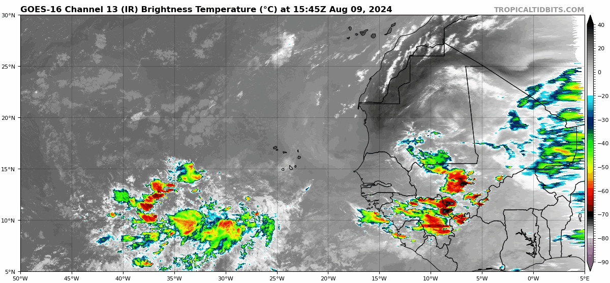
The wave in question is gaining a bit of convection this afternoon:
7 likes
TC naming lists: retirements and intensity
Most aggressive Advisory #1's in North Atlantic (cr. kevin for starting the list)
Most aggressive Advisory #1's in North Atlantic (cr. kevin for starting the list)
-
IsabelaWeather
- Category 1
- Posts: 316
- Age: 36
- Joined: Tue Jul 07, 2020 7:29 am
- Location: Isabela, Puerto Rico
Re: Tropical Wave in Eastern Atlantic (0/60)
Teban54 wrote:The wave in question is gaining a bit of convection this afternoon:
https://i.postimg.cc/05wbn37L/goes16-ir-eatl.gif
DMAX ought to be interesting. Looks like a general broad circulation now that I dont remember seeing yesterday.
1 likes

Re: Tropical Wave in Eastern Atlantic (0/60)
toad strangler wrote:aspen wrote:
Look at that one ensemble member has a Cat 1/2 hit in the NYC area. Thankfully it’s an outlier for now.
I rarely opine on individual ensemble members but that same member you cite equally threatens WPB FL, Cape Hatteras NC, and the NJ shore before approaching the NYC area.
Yep. Basically a bigger, badder Irene.
Hard to tell right now if we’re actually at risk here in the NE. We just have to wait for a TC to form to narrow down exactly when and where this’ll start turning north.
1 likes
Irene '11 Sandy '12 Hermine '16 5/15/2018 Derecho Fay '20 Isaias '20 Elsa '21 Henri '21 Ida '21
I am only a meteorology enthusiast who knows a decent amount about tropical cyclones. Look to the professional mets, the NHC, or your local weather office for the best information.
I am only a meteorology enthusiast who knows a decent amount about tropical cyclones. Look to the professional mets, the NHC, or your local weather office for the best information.
-
Tekken_Guy
- Tropical Storm
- Posts: 150
- Joined: Fri Sep 01, 2017 8:08 pm
Re: Tropical Wave in Eastern Atlantic (0/60)
aspen wrote:toad strangler wrote:aspen wrote:Look at that one ensemble member has a Cat 1/2 hit in the NYC area. Thankfully it’s an outlier for now.
I rarely opine on individual ensemble members but that same member you cite equally threatens WPB FL, Cape Hatteras NC, and the NJ shore before approaching the NYC area.
Yep. Basically a bigger, badder Irene.
Hard to tell right now if we’re actually at risk here in the NE. We just have to wait for a TC to form to narrow down exactly when and where this’ll start turning north.
Would this be Sandy-level bad for us?
0 likes
-
cycloneye

- Admin

- Posts: 149703
- Age: 69
- Joined: Thu Oct 10, 2002 10:54 am
- Location: San Juan, Puerto Rico
Re: Tropical Wave in Eastern Atlantic (0/60)
Very good from the NWS of San Juan to alert the population this early about what may unfold by tuesday thru wednesday here in PR.
https://x.com/NWSSanJuan/status/1821995260584849755
https://x.com/NWSSanJuan/status/1821995260584849755
2 likes
Visit the Caribbean-Central America Weather Thread where you can find at first post web cams,radars
and observations from Caribbean basin members Click Here
and observations from Caribbean basin members Click Here
Re: Tropical Wave in Eastern Atlantic (0/60)
Tekken_Guy wrote:aspen wrote:toad strangler wrote:
I rarely opine on individual ensemble members but that same member you cite equally threatens WPB FL, Cape Hatteras NC, and the NJ shore before approaching the NYC area.
Yep. Basically a bigger, badder Irene.
Hard to tell right now if we’re actually at risk here in the NE. We just have to wait for a TC to form to narrow down exactly when and where this’ll start turning north.
Would this be Sandy-level bad for us?
If we were to get hit by a Cat 1/2 like that, possibly worse. I remember a post or article from Crown Weather earlier this year where he expressed his concerns about a significant northeast hurricane strike. Since it’s been so long since the last significant hurricane landfall in New England (one of the storms from 1954 IIRC), there’s been a lot of population and tree growth, and said population (plus our electrical grid) is in no way prepared for a 90-100+ mph hurricane strike. Such a wind event will topple a lot of the now-mature trees and could cripple the grid for months. Worse wind damage than Sandy or Irene.
Fortunately, the northeast is a pretty difficult target for tropical systems, and it’s still way too far out to confidently say that we’ll see any impacts from future Ernesto. The odds of us getting that exact ensemble member track and intensity are very low.
1 likes
Irene '11 Sandy '12 Hermine '16 5/15/2018 Derecho Fay '20 Isaias '20 Elsa '21 Henri '21 Ida '21
I am only a meteorology enthusiast who knows a decent amount about tropical cyclones. Look to the professional mets, the NHC, or your local weather office for the best information.
I am only a meteorology enthusiast who knows a decent amount about tropical cyclones. Look to the professional mets, the NHC, or your local weather office for the best information.

Re: Tropical Wave in Eastern Atlantic (0/60)
Teban54 wrote:The wave in question is gaining a bit of convection this afternoon:
https://i.postimg.cc/05wbn37L/goes16-ir-eatl.gif
Looks like a lot more trouble coming off the coast of Africa
1 likes
-
OuterBanker
- S2K Supporter
- Posts: 1761
- Joined: Wed Feb 26, 2003 10:53 am
- Location: Nags Head, NC
- Contact:
Re: Tropical Wave in Eastern Atlantic (0/60)
12z GFS https://www.tropicaltidbits.com/analysi ... 912&fh=228
6z GFS https://www.tropicaltidbits.com/analysi ... 906&fh=234
12z Euro https://www.tropicaltidbits.com/analysi ... 912&fh=240
12z CMC https://www.tropicaltidbits.com/analysi ... 912&fh=240
for giggles yesterdays 00z Euro. https://www.tropicaltidbits.com/analysi ... 912&fh=240
Not all are fish. Yesterday the Euro flattened the OBX today safely out to sea.
Yesterday GFS out to sea today across the OBX.
Let's face it 10 days should should be used for entertainment purposes only.
Maybe GFS was a little more accurate a day out on Debby. But, the day before it and the HWRF shared some mushrooms and sent Debby to die in Ga,
Euro and Icon sent a cat 2 up the NC coast. Never happened either.
Btw, CMC doesn't show anything because it lifts before 60w.
6 likes
-
Category5Kaiju

- Category 5
- Posts: 4345
- Joined: Thu Dec 24, 2020 12:45 pm
- Location: Seattle during the summer, Phoenix during the winter
Re: Tropical Wave in Eastern Atlantic (0/60)
aspen wrote:Tekken_Guy wrote:aspen wrote:Yep. Basically a bigger, badder Irene.
Hard to tell right now if we’re actually at risk here in the NE. We just have to wait for a TC to form to narrow down exactly when and where this’ll start turning north.
Would this be Sandy-level bad for us?
If we were to get hit by a Cat 1/2 like that, possibly worse. I remember a post or article from Crown Weather earlier this year where he expressed his concerns about a significant northeast hurricane strike. Since it’s been so long since the last significant hurricane landfall in New England (one of the storms from 1954 IIRC), there’s been a lot of population and tree growth, and said population (plus our electrical grid) is in no way prepared for a 90-100+ mph hurricane strike. Such a wind event will topple a lot of the now-mature trees and could cripple the grid for months. Worse wind damage than Sandy or Irene.
Fortunately, the northeast is a pretty difficult target for tropical systems, and it’s still way too far out to confidently say that we’ll see any impacts from future Ernesto. The odds of us getting that exact ensemble member track and intensity are very low.
I can't imagine what it would look like if we were to get a 1938-style hit in that region during the present day. Basically, a bona fide Category 3 cyclone.
On the flip side, yes, the angle that a tropical cyclone would need to go on to strike the Northeast, let alone as a hurricane (not an extratropical system), is very difficult to achieve.
0 likes
Unless explicitly stated, all information in my posts is based on my own opinions and observations. Tropical storms and hurricanes can be extremely dangerous. Refer to an accredited weather research agency or meteorologist if you need to make serious decisions regarding an approaching storm.

Re: Tropical Wave in Eastern Atlantic (0/60)
Teban54 wrote:The wave in question is gaining a bit of convection this afternoon:
https://i.postimg.cc/05wbn37L/goes16-ir-eatl.gif
Also, a large gyre is now becoming more evident from the movement of the said convection.
Last edited by abajan on Fri Aug 09, 2024 5:09 pm, edited 1 time in total.
4 likes
-
Tekken_Guy
- Tropical Storm
- Posts: 150
- Joined: Fri Sep 01, 2017 8:08 pm
Re: Tropical Wave in Eastern Atlantic (0/60)
Category5Kaiju wrote:aspen wrote:Tekken_Guy wrote:
Would this be Sandy-level bad for us?
If we were to get hit by a Cat 1/2 like that, possibly worse. I remember a post or article from Crown Weather earlier this year where he expressed his concerns about a significant northeast hurricane strike. Since it’s been so long since the last significant hurricane landfall in New England (one of the storms from 1954 IIRC), there’s been a lot of population and tree growth, and said population (plus our electrical grid) is in no way prepared for a 90-100+ mph hurricane strike. Such a wind event will topple a lot of the now-mature trees and could cripple the grid for months. Worse wind damage than Sandy or Irene.
Fortunately, the northeast is a pretty difficult target for tropical systems, and it’s still way too far out to confidently say that we’ll see any impacts from future Ernesto. The odds of us getting that exact ensemble member track and intensity are very low.
I can't imagine what it would look like if we were to get a 1938-style hit in that region during the present day. Basically, a bona fide Category 3 cyclone.
On the flip side, yes, the angle that a tropical cyclone would need to go on to strike the Northeast, let alone as a hurricane (not an extratropical system), is very difficult to achieve.
Yeah that’s why we usually only get weakened storms like Floyd and Irene. Everything needs to go wrong for the worst to happen.
0 likes
Who is online
Users browsing this forum: pepecool20 and 174 guests