ATL: ERNESTO - Models

Moderator: S2k Moderators

Message
Author
User avatar
cycloneye
Admin
Admin
Posts: 143862
Age: 68
Joined: Thu Oct 10, 2002 10:54 am
Location: San Juan, Puerto Rico

ATL: ERNESTO - Models

#1 Postby cycloneye » Fri Aug 09, 2024 7:35 pm

Model runs here.

18z GEFS ensembles run.

Image
0 likes   
Visit the Caribbean-Central America Weather Thread where you can find at first post web cams,radars
and observations from Caribbean basin members Click Here

User avatar
Blown Away
S2K Supporter
S2K Supporter
Posts: 10140
Joined: Wed May 26, 2004 6:17 am

Re: ATL: INVEST 98L - Models

#2 Postby Blown Away » Fri Aug 09, 2024 8:41 pm

That sharp N turn seems kinda of extreme… My guess is 98L will trend W into the GA Islands and a threat to Bahamas/SFL/Carolinas… JMHO
0 likes   
Hurricane Eye Experience: David 79, Irene 99, Frances 04, Jeanne 04, Wilma 05... EYE COMING MY WAY IN 2024…
Hurricane Brush Experience: Andrew 92, Erin 95, Floyd 99, Matthew 16, Irma 17, Ian 22, Nicole 22…

User avatar
SFLcane
S2K Supporter
S2K Supporter
Posts: 10162
Age: 47
Joined: Sat Jun 05, 2010 1:44 pm
Location: Lake Worth Florida

Re: ATL: INVEST 98L - Models

#3 Postby SFLcane » Fri Aug 09, 2024 9:04 pm

Talk about big spread like Debby plenty of land interaction which awaits this wave could make this just a tad tricky once again.

Image
1 likes   

User avatar
Nimbus
Category 5
Category 5
Posts: 5274
Joined: Mon Jul 19, 2004 10:54 am

Re: ATL: INVEST 98L - Models

#4 Postby Nimbus » Fri Aug 09, 2024 9:41 pm

A few years ago we would assume that the models would recurve the storm tracks early as a default.
Not sure the long range accuracy has improved that much since then.
1 likes   

Nuno
Category 2
Category 2
Posts: 591
Joined: Fri Aug 30, 2019 8:35 am
Location: Coral Gables, FL

Re: ATL: INVEST 98L - Models

#5 Postby Nuno » Fri Aug 09, 2024 9:44 pm

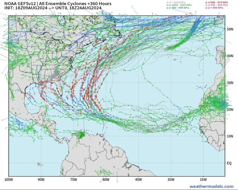
Nimbus wrote:A few years ago we would assume that the models would recurve the storm tracks early as a default.
Not sure the long range accuracy has improved that much since then.


I feel I trust models way less now mid-long range than I did years ago which wasn't much to begin with. I think the land interaction as others are saying is key.

Debby was supposed to curve north of the Greater Antilles and east of Florida and that was only a few days out and we saw that happened.
1 likes   
Andrew (1992), Irene (1999), Frances (2004), Katrina (2005), Wilma (2005), Fay (2008), Irma (2017), Eta (2020), Ian (2022)

BobHarlem
Category 5
Category 5
Posts: 2034
Joined: Thu Oct 20, 2005 6:11 pm

Re: ATL: INVEST 98L - Models

#6 Postby BobHarlem » Fri Aug 09, 2024 10:18 pm

0z icon is a good deal right of 12z and stays just offshore or scraping along the northern edge of the leewards. Only slightly right of the 18z. Winds up north of Puerto Rico, then starts to recurve more sharply north of Puerto Rico and never even gets close to the Turks and Caicos like it did on the 12z. Bermuda is much more likely than the mainland US here. Hope this is a trend for the rest of the models later tonight.

Although it's worth nothing there's 4-5 other areas beyond 98l on the last few frames of the icon. (3 of them on the screenshot below, 2 more to the right of that)

0z Icon Way right of 12z icon:
Image
Last edited by BobHarlem on Fri Aug 09, 2024 10:46 pm, edited 5 times in total.
1 likes   

User avatar
toad strangler
S2K Supporter
S2K Supporter
Posts: 4543
Joined: Sun Jul 28, 2013 3:09 pm
Location: Earth
Contact:

Re: ATL: INVEST 98L - Models

#7 Postby toad strangler » Fri Aug 09, 2024 10:30 pm

BobHarlem wrote:0z icon is a good deal right of 12z and stays just offshore or scraping along the northern edge of the leewards. Only slightly right of the 18z. Winds up north of Puerto Rico, then starts to recurve more sharply north of Puerto Rico and never even gets close to the Turks and Caicos like it did on the 12z. Hope this is a trend for the rest of the models later tonight.


Would be nice to finally see a 2024 Atlantic Basin Cyclone go the climo route and scoot on out with minimal land interaction.
0 likes   

BobHarlem
Category 5
Category 5
Posts: 2034
Joined: Thu Oct 20, 2005 6:11 pm

Re: ATL: INVEST 98L - Models

#8 Postby BobHarlem » Fri Aug 09, 2024 11:01 pm

0z gfs is a little left (aka south) of 18z so far.

0z goes over Martinique in the Leewards rather than Guadalupe in the 18z, but by hour 108 is in a pretty similar spot to 18z.

After that it starts to go left more, but a bit weaker, looks like it may go over or ride the south side of Hispaniola this run, and smack into Haiti around hour 129.

Then exits that and heads toward the Turks and Caicos and starts into the Bahamas but turns north before it reaches the central Bahamas, much much weaker obviously than 18z, but still well right of 12z.

GFS has a noticable slowdown around hour 165 this run, then moves a bit ne.

But by hour 220 it's back in a very similar spot to 18z. Watching influence of an area in the mid west though, that may tug left or at least keep it going north, but ultimately fails to do so, winds up well right of 18z by hour 240 and out to sea (north of Bermuda)


Hispaniola Impact here on 0z gfs:
Image
Exit the shredder here:
Image
Gets through the Turks and Caicos as a weak system and parts of the Southeastern Bahamas, but goes north and eventually out to sea.
Image


0z canadian is pure fish, it still curves it north before it reaches the islands, but it gets it a little closer to them this time, and still stays way east of Bermuda.
Last edited by BobHarlem on Fri Aug 09, 2024 11:44 pm, edited 11 times in total.
0 likes   

LarryWx
Category 5
Category 5
Posts: 6246
Joined: Sun Sep 07, 2003 2:04 pm
Location: GA

Re: ATL: INVEST 98L - Models

#9 Postby LarryWx » Fri Aug 09, 2024 11:21 pm

0Z UK: recurved 69-70W:

NEW TROPICAL CYCLONE FORECAST TO DEVELOP AFTER 120 HOURS
FORECAST POSITION AT T+120 : 20.9N 69.3W

LEAD CENTRAL MAXIMUM WIND
VERIFYING TIME TIME POSITION PRESSURE (MB) SPEED (KNOTS)
-------------- ---- -------- ------------- -------------
0000UTC 15.08.2024 120 20.9N 69.3W 1010 34
1200UTC 15.08.2024 132 23.5N 69.8W 1008 40
0000UTC 16.08.2024 144 25.6N 69.4W 1006 41
1200UTC 16.08.2024 156 27.2N 69.2W 1003 43
0000UTC 17.08.2024 168 28.4N 69.4W 1001 41
0 likes   
Personal Forecast Disclaimer:
The posts in this forum are NOT official forecasts and should not be used as such. They are just the opinion of the poster and may or may not be backed by sound meteorological data. They are NOT endorsed by any professional institution or storm2k.org. For official information, please refer to the NHC and NWS products.

Stratton23
Category 5
Category 5
Posts: 2370
Joined: Fri Jul 21, 2023 10:59 pm
Location: Katy, Tx

Re: ATL: INVEST 98L - Models

#10 Postby Stratton23 » Fri Aug 09, 2024 11:27 pm

Im leaning towards a weaker system like the GFS shows, I just dont buy the CMC solution with a recurve that soon, I think we will see a correction closer towards the bahamas or close to, im thinking this gets further west than currently depicted because I think this wave will be slower to develop , just my opinion ,
0 likes   

User avatar
aspen
Category 5
Category 5
Posts: 8812
Joined: Sat Oct 12, 2019 7:10 pm
Location: Connecticut, USA

Re: ATL: INVEST 98L - Models

#11 Postby aspen » Fri Aug 09, 2024 11:31 pm

BobHarlem wrote:0z gfs is a little left (aka south) of 18z so far.

0z goes over Martinique in the Leewards rather than Guadalupe in the 18z, but by hour 108 is in a pretty similar spot to 18z.

After that it starts to go left more, but a bit weaker, looks like it may go over or ride the south side of Hispaniola this run, and smack into Haiti around hour 129.

Then exits that and heads toward the Turks and Caicos and starts into the Bahamas but turns north before it reaches the central Bahamas, much much weaker obviously than 18z, but still well right of 12z.

GFS has a noticable slowdown around hour 165 this run, then moves a bit ne.


Hispaniola Impact here on 0z gfs:
https://i.imgur.com/2JU5ZOE.png
Exit the shredder here:
https://i.imgur.com/I36BSkq.png


0z canadian is pure fish, it still curves it north before it reaches the islands, but it gets it a little closer to them this time, and still stays way east of Bermuda.

The 0z GFS ends up so far south because it has two competing vortexes in the wave envelope. First the southern end tried to become dominant, then the north tries to take over, but by then it’s south of the Virgin Islands so it hits the Shredder. This is the first time any model run has shown such a development history for 98L.
0 likes   
Irene '11 Sandy '12 Hermine '16 5/15/2018 Derecho Fay '20 Isaias '20 Elsa '21 Henri '21 Ida '21

I am only a meteorology enthusiast who knows a decent amount about tropical cyclones. Look to the professional mets, the NHC, or your local weather office for the best information.

User avatar
Kazmit
Category 5
Category 5
Posts: 2124
Age: 22
Joined: Mon Jul 25, 2016 8:49 am
Location: Williamsburg, VA / Bermuda

Re: ATL: INVEST 98L - Models

#12 Postby Kazmit » Sat Aug 10, 2024 12:16 am

0z GFS has quite a trough for this time of year. Starts moving due north around the Turks and Caicos as a depression. Seems odd.
0 likes   
Igor 2010, Sandy 2012, Fay 2014, Gonzalo 2014, Joaquin 2015, Nicole 2016, Humberto 2019

I am only a tropical weather enthusiast. My predictions are not official and may or may not be backed by sound meteorological data. For official information, please refer to the NHC and NWS products.

User avatar
chaser1
S2K Supporter
S2K Supporter
Posts: 5406
Age: 64
Joined: Sat Oct 15, 2005 5:59 pm
Location: Longwood, Fl

Re: ATL: INVEST 98L - Models

#13 Postby chaser1 » Sat Aug 10, 2024 1:30 am

Kazmit wrote:0z GFS has quite a trough for this time of year. Starts moving due north around the Turks and Caicos as a depression. Seems odd.


Exactly my thought That sudden deep trough dropping during what has been an otherwise very surpressed zonal Westerlies flow with rock solid low latitude ridging seemingly across the entire Atlantic basin, better yet ... to occur in AUGUST?? Its beyond odd - and remarkably lucky.
1 likes   
Andy D

(For official information, please refer to the NHC and NWS products.)

LarryWx
Category 5
Category 5
Posts: 6246
Joined: Sun Sep 07, 2003 2:04 pm
Location: GA

Re: ATL: INVEST 98L - Models

#14 Postby LarryWx » Sat Aug 10, 2024 1:39 am

0Z Euro suite: little change from recent runs; a few E coast but most recurve E of E coast
0 likes   
Personal Forecast Disclaimer:
The posts in this forum are NOT official forecasts and should not be used as such. They are just the opinion of the poster and may or may not be backed by sound meteorological data. They are NOT endorsed by any professional institution or storm2k.org. For official information, please refer to the NHC and NWS products.

User avatar
weeniepatrol
Category 5
Category 5
Posts: 1252
Joined: Sat Aug 22, 2020 5:30 pm
Location: WA State

Re: ATL: INVEST 98L - Models

#15 Postby weeniepatrol » Sat Aug 10, 2024 4:42 am

Image

00z EPS shifted west.
2 likes   

User avatar
weeniepatrol
Category 5
Category 5
Posts: 1252
Joined: Sat Aug 22, 2020 5:30 pm
Location: WA State

Re: ATL: INVEST 98L - Models

#16 Postby weeniepatrol » Sat Aug 10, 2024 5:24 am

6z gfs much stronger. Cat 2 into Hispaniola.
0 likes   

User avatar
aspen
Category 5
Category 5
Posts: 8812
Joined: Sat Oct 12, 2019 7:10 pm
Location: Connecticut, USA

Re: ATL: INVEST 98L - Models

#17 Postby aspen » Sat Aug 10, 2024 5:26 am

6z GFS develops within 2-3 days and goes south of the Virgin Islands again. Stronger within 6 days than the 0z run, with a hurricane into the DR.

Seems like the GFS and Euro both agree on the storm recurving between the CONUS and Bermuda after impacting the NW Caribbean islands, which could put Atlantic Canada into play. They can’t seem to catch a break.

The first HWRF and HMON models have 98L going north of St Martin/Antigua/Barbuda as a hurricane, showing an earlier recurve than the GFS/Euro/ICON (although not as early as the CMC, which is allergic to 98L getting much further west than 60W).
1 likes   
Irene '11 Sandy '12 Hermine '16 5/15/2018 Derecho Fay '20 Isaias '20 Elsa '21 Henri '21 Ida '21

I am only a meteorology enthusiast who knows a decent amount about tropical cyclones. Look to the professional mets, the NHC, or your local weather office for the best information.

zzzh
Category 3
Category 3
Posts: 833
Joined: Thu Sep 02, 2021 1:13 pm

Re: ATL: INVEST 98L - Models

#18 Postby zzzh » Sat Aug 10, 2024 5:30 am

GFS 06/18z runs are considerably stronger than 00/12z runs, I wouldn't trust it too much.
0 likes   

mantis83
Tropical Storm
Tropical Storm
Posts: 198
Joined: Fri Dec 05, 2003 4:47 pm

Re: ATL: INVEST 98L - Models

#19 Postby mantis83 » Sat Aug 10, 2024 6:02 am

Based on the models, it could produce some decent ace points...... 8-)
0 likes   

BobHarlem
Category 5
Category 5
Posts: 2034
Joined: Thu Oct 20, 2005 6:11 pm

Re: ATL: INVEST 98L - Models

#20 Postby BobHarlem » Sat Aug 10, 2024 6:07 am

On both the 0z and 6z GFS this system is an ace generator as it makes it all the way back to nearly the Azores intact once it does recurve.
0 likes   


Return to “2024”

Who is online

Users browsing this forum: No registered users and 6 guests