2024 Global Model Runs Discussion (Out thru day 16)

This is the general tropical discussion area. Anyone can take their shot at predicting a storms path.

Moderator: S2k Moderators

Forum rules

The posts in this forum are NOT official forecasts and should not be used as such. They are just the opinion of the poster and may or may not be backed by sound meteorological data. They are NOT endorsed by any professional institution or STORM2K. For official information, please refer to products from the National Hurricane Center and National Weather Service.

Help Support Storm2K
Message
Author
User avatar
Steve
S2K Supporter
S2K Supporter
Posts: 9620
Joined: Sat Apr 05, 2003 11:41 pm
Location: Not a state-caster

Re: 2024 Global Model Runs Discussion (Out thru day 16)

#841 Postby Steve » Wed Aug 14, 2024 2:58 pm

zzzh wrote:https://i.imgur.com/TSUwZZU.png
Just like that


August 29th. Katrina, Ida.
1 likes   

User avatar
Steve
S2K Supporter
S2K Supporter
Posts: 9620
Joined: Sat Apr 05, 2003 11:41 pm
Location: Not a state-caster

Re: 2024 Global Model Runs Discussion (Out thru day 16)

#842 Postby Steve » Wed Aug 14, 2024 3:00 pm

toad strangler wrote:
Steve wrote:
jlauderdal wrote:13 weeks gets us into the first week of September, CSU calling for 23 NS and we have had 5. 18 storms in 13 weeks, not buying it, my 19 NS might be high but we will see. The math is the math :D . I would take my 19 down to 17 if I had a redo, less storms but same ACE.


Gonna take some simultaneous systems to get there. I'm not sure where we are as far as named storm days or hurricane days so far, but CSU called for 120 named storm days and 50 hurricane days. I'm assuming we're roughly 15-20 into NS and probably 5 or 6 into H days. If that assumption is close, there are 108 days until November 30th though we know that most of November won't feature activity (might be one or two ocean systems or in the Caribbean due to the La Nina). We would have 100 named storm days to go which is about a constant system between now and the end of the season adjusted by however many simultaneous storms there are to offset the days without any named storms.

I don't have an opinion one way or the other on this. There are times when bursts bring on 2, 3 or even 4 systems. But there are usually only a couple of these a season that even features those. So it's all a big ? to me until we hit 4-5 weeks from now and see what we are dealing with numbers wise.


As of 03:00 MT this morning .... climatology norm 1991 - 2020 in ()
18.5 NS days (11.9)
6.5 H days (2.2)
42.2 ACE (14.1 AVG)
4.5 MH days (0.4)


Thanks Toad. In other words we ain’t seen nothing yet. Also glad I was somewhat in the ranges and not just typing out of my ***.
2 likes   

User avatar
Category5Kaiju
Category 5
Category 5
Posts: 4096
Joined: Thu Dec 24, 2020 12:45 pm
Location: Seattle

Re: 2024 Global Model Runs Discussion (Out thru day 16)

#843 Postby Category5Kaiju » Wed Aug 14, 2024 3:05 pm

zzzh wrote:https://i.imgur.com/TSUwZZU.png
Just like that


Merely a single day ago, there were talks of the season busting with models not detecting anything in the future.

Alarm clock effect in play, as per usual.
5 likes   
Unless explicitly stated, all info in my posts is based on my own opinions and observations. Tropical storms and hurricanes can be extremely dangerous. Do not think you can beat Mother Nature. Refer to an accredited weather research agency or meteorologist if you need to make serious decisions regarding an approaching storm.

User avatar
AnnularCane
S2K Supporter
S2K Supporter
Posts: 2862
Joined: Thu Jun 08, 2006 9:18 am
Location: Wytheville, VA

Re: 2024 Global Model Runs Discussion (Out thru day 16)

#844 Postby AnnularCane » Wed Aug 14, 2024 3:16 pm

skyline385 wrote:And there's the switch flip coming, just like every year

https://i.imgur.com/gQjTGAq.png


Are they really coming off that far north though? That doesn't look right. :lol:
0 likes   
"But it never rained rain. It never snowed snow. And it never blew just wind. It rained things like soup and juice. It snowed mashed potatoes and green peas. And sometimes the wind blew in storms of hamburgers." -- Judi Barrett, Cloudy with a Chance of Meatballs

User avatar
skyline385
Category 5
Category 5
Posts: 2728
Age: 35
Joined: Wed Aug 26, 2020 11:15 pm
Location: Houston TX

Re: 2024 Global Model Runs Discussion (Out thru day 16)

#845 Postby skyline385 » Wed Aug 14, 2024 3:18 pm

AnnularCane wrote:
skyline385 wrote:And there's the switch flip coming, just like every year

https://i.imgur.com/gQjTGAq.png


Are they really coming off that far north though? That doesn't look right. :lol:


Nah, its correct. This is a good thread on the topic

 https://x.com/WxTca/status/1823493478892122501

0 likes   

User avatar
Beef Stew
Category 1
Category 1
Posts: 498
Joined: Sat May 30, 2020 11:31 am
Location: South Florida

Re: 2024 Global Model Runs Discussion (Out thru day 16)

#846 Postby Beef Stew » Wed Aug 14, 2024 3:20 pm

I’ve noticed in recent years it really seems like the models do a very poor job at picking up the onset of peak season. I’m basing this off nothing but memory, but most of the activity we’ve seen happen in late August/early September wasn’t really picked up on until ~5 days in advance- and then suddenly there’s multiple areas of interest and even some significant storms in the making. This time of year, things tend to happen fast.

While it looks like ensembles have perked up a bit today, even if the signal subsides I personally would bet that any modeled “calm” in late August/early September is likely an illusion. Ultimately, if I had to bet on it, I’d say that someone- be it the islands, GOM, or east coast- will be staring down the barrel of an approaching storm come two weeks from today.
Last edited by Beef Stew on Wed Aug 14, 2024 3:22 pm, edited 1 time in total.
5 likes   

User avatar
chaser1
S2K Supporter
S2K Supporter
Posts: 5464
Age: 64
Joined: Sat Oct 15, 2005 5:59 pm
Location: Longwood, Fl

Re: 2024 Global Model Runs Discussion (Out thru day 16)

#847 Postby chaser1 » Wed Aug 14, 2024 3:20 pm

The general public (and fair extent of the media) simply do not understand the concept that Global Models do not have a memory. They are good at picking up strong signals and typically better forecasting with "all of the players on the field". The GFS had forever been solid in sniffing out genesis but with too many false negatives. That is why following the more subtle increase/decrease in the ensembles offers better hints toward an upswing in activity. Even still.... one day the ensembles see nothing, and next model run suddenly picks up the scent. Not much different from hunting dogs bred to hunt. Forecast models are our generations' Weather AI bloodhounds :cheesy:
5 likes   
Andy D

(For official information, please refer to the NHC and NWS products.)

User avatar
skyline385
Category 5
Category 5
Posts: 2728
Age: 35
Joined: Wed Aug 26, 2020 11:15 pm
Location: Houston TX

Re: 2024 Global Model Runs Discussion (Out thru day 16)

#848 Postby skyline385 » Wed Aug 14, 2024 3:25 pm

chaser1 wrote:The general public (and fair extent of the media) simply do not understand the concept that Global Models do not have a memory. They are good at picking up strong signals and typically better forecasting with "all of the players on the field". The GFS had forever been solid in sniffing out genesis but with too many false negatives. That is why following the more subtle increase/decrease in the ensembles offers better hints toward an upswing in activity. Even still.... one day the ensembles see nothing, and next model run suddenly picks up the scent. Not much different from hunting dogs bred to hunt. Forecast models are our generations' Weather AI bloodhounds :cheesy:


Well said, numerical models are basically that - just numbers and equations. They do not know that climatologically conditions in the NATL will suddenly flip near August 20th to be very favorable and they are only able to calculate based on what was used in their initialization which is 10-15 days before the switch flip depending on the model which is in most cases generally unfavorable in the NATL. I expect this to change as we switch to hybrid and AI models in the future which are trained on past data but for now, we can't really do anything about the limitations of the model arising from them being completely numerical in nature.
2 likes   

jlauderdal
S2K Supporter
S2K Supporter
Posts: 7182
Joined: Wed May 19, 2004 5:46 am
Location: NE Fort Lauderdale
Contact:

Re: RE: Re: 2024 Global Model Runs Discussion (Out thru day 16)

#849 Postby jlauderdal » Wed Aug 14, 2024 3:46 pm

Steve wrote:
toad strangler wrote:
Steve wrote:
Gonna take some simultaneous systems to get there. I'm not sure where we are as far as named storm days or hurricane days so far, but CSU called for 120 named storm days and 50 hurricane days. I'm assuming we're roughly 15-20 into NS and probably 5 or 6 into H days. If that assumption is close, there are 108 days until November 30th though we know that most of November won't feature activity (might be one or two ocean systems or in the Caribbean due to the La Nina). We would have 100 named storm days to go which is about a constant system between now and the end of the season adjusted by however many simultaneous storms there are to offset the days without any named storms.

I don't have an opinion one way or the other on this. There are times when bursts bring on 2, 3 or even 4 systems. But there are usually only a couple of these a season that even features those. So it's all a big ? to me until we hit 4-5 weeks from now and see what we are dealing with numbers wise.


As of 03:00 MT this morning .... climatology norm 1991 - 2020 in ()
18.5 NS days (11.9)
6.5 H days (2.2)
42.2 ACE (14.1 AVG)
4.5 MH days (0.4)


Thanks Toad. In other words we ain’t seen nothing yet. Also glad I was somewhat in the ranges and not just typing out of my ***.
20+ is certainly not off the table but I look at the math and the idea its difficult to get everything to align for a NS.
1 likes   

User avatar
MetroMike
Category 4
Category 4
Posts: 952
Joined: Sun Aug 29, 2004 8:13 pm
Location: Tampa Bay
Contact:

Re: 2024 Global Model Runs Discussion (Out thru day 16)

#850 Postby MetroMike » Wed Aug 14, 2024 4:13 pm

According to Yaakov Cantor on X he replied to me saying the EPS has a bias of moving waves too far north off the African coast in the long range forecasts. So that posted graphic from earlier shows said bias.
6 likes   

User avatar
skyline385
Category 5
Category 5
Posts: 2728
Age: 35
Joined: Wed Aug 26, 2020 11:15 pm
Location: Houston TX

Re: 2024 Global Model Runs Discussion (Out thru day 16)

#851 Postby skyline385 » Wed Aug 14, 2024 4:44 pm

MetroMike wrote:According to Yaakov Cantor on X he replied to me saying the EPS has a bias of moving waves too far north off the African coast in the long range forecasts. So that posted graphic from earlier shows said bias.


EPS has a bias of sometimes having waves form too north from brown water intensification inland but as we have seen this year in the thread started by TCA, the AEJ is abnormally north resulting in waves dropping much higher that what is normal for this time of year. When the EPS does it as a result of its bias, you can tell as waves drop down at TS strength or even hurricane strength sometimes, that is not the case for a majority of members on the run posted earlier so it is very likely that it not showing much bias this run especially since we know that the AEJ is abnormally elevated this year.

Am posting the same thread here as well, I would seriously recommend going through it as it provides a good explanation for the issues we saw in July and early August this year.

 https://x.com/WxTca/status/1823493478892122501

4 likes   

Stratton23
Category 5
Category 5
Posts: 2519
Joined: Fri Jul 21, 2023 10:59 pm
Location: Katy, Tx

Re: 2024 Global Model Runs Discussion (Out thru day 16)

#852 Postby Stratton23 » Wed Aug 14, 2024 6:13 pm

18z GFS starting to slowly see the switch now, has a little gulf mischief in the 10–12 day range lol
1 likes   

User avatar
Hammy
Category 5
Category 5
Posts: 5849
Age: 41
Joined: Fri May 25, 2012 5:25 pm
Contact:

Re: 2024 Global Model Runs Discussion (Out thru day 16)

#853 Postby Hammy » Wed Aug 14, 2024 6:20 pm

And there it is

Image

Probably wont be there on the next run, GFS is off and on with this until it gets closer, but we have a low center and a fairly tight, lower-latitude wave at the end of today's run, something that has been completely absent for weeks of model runs

It's the first sign the flip is near
5 likes   
The above post is not official and should not be used as such. It is the opinion of the poster and may or may not be backed by sound meteorological data. It is not endorsed by any professional institution or storm2k.org. For official information, please refer to the NHC and NWS products.

User avatar
Ubuntwo
Category 5
Category 5
Posts: 1406
Age: 31
Joined: Thu Oct 05, 2017 10:41 pm

Re: 2024 Global Model Runs Discussion (Out thru day 16)

#854 Postby Ubuntwo » Wed Aug 14, 2024 7:45 pm

MDR signal now showing up on the GFS ensembles as well.

Image
4 likes   
Kendall -> SLO -> PBC

Memorable Storms: Katrina (for its Florida landfall...) Wilma Matthew Irma

User avatar
toad strangler
S2K Supporter
S2K Supporter
Posts: 4543
Joined: Sun Jul 28, 2013 3:09 pm
Location: Earth
Contact:

Re: 2024 Global Model Runs Discussion (Out thru day 16)

#855 Postby toad strangler » Wed Aug 14, 2024 8:02 pm

Hammy wrote:And there it is

https://i.imgur.com/GcB84rF.png

Probably wont be there on the next run, GFS is off and on with this until it gets closer, but we have a low center and a fairly tight, lower-latitude wave at the end of today's run, something that has been completely absent for weeks of model runs

It's the first sign the flip is near

There is real ACE ticking off since yesterday and will go on for the rest of the week into the weekend and beyond most likely. I’m not sure if the switch hasn’t already gone north.
6 likes   

AutoPenalti
Category 5
Category 5
Posts: 4030
Age: 29
Joined: Mon Aug 17, 2015 4:16 pm
Location: Ft. Lauderdale, Florida

Re: 2024 Global Model Runs Discussion (Out thru day 16)

#856 Postby AutoPenalti » Thu Aug 15, 2024 6:37 am

Some people here seem to forget that models, especially the ensembles, runs 4 times a day with each run having a completely different solution. One run may have 3 different storms at once vs the prior one, merely 6 hours apart, which had none. Each run we get throughout the day is an opportunity to light up the basin.

Edit:
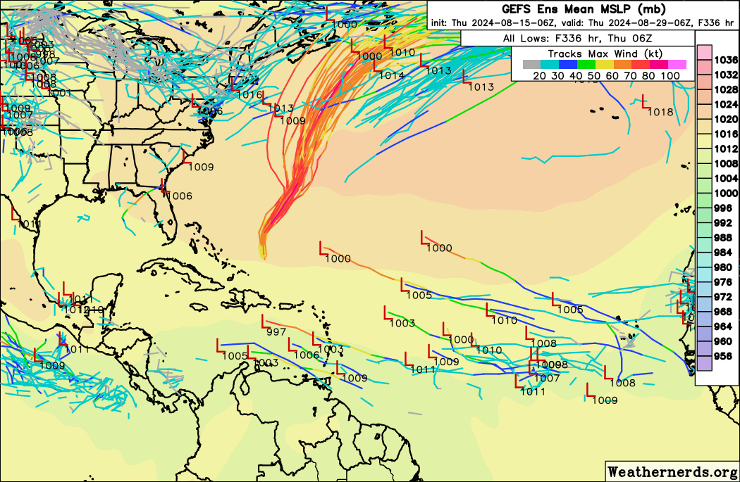
GEFS starting to show some noodles.

Image
1 likes   
The posts in this forum are NOT official forecasts and should not be used as such. They are just the opinion of the poster and may or may not be backed by sound meteorological data. They are NOT endorsed by any professional institution or STORM2K. For official information, please refer to products from the NHC and NWS.


Model Runs Cheat Sheet:
GFS (5:30 AM/PM, 11:30 AM/PM)
HWRF, GFDL, UKMET, NAVGEM (6:30-8:00 AM/PM, 12:30-2:00 AM/PM)
ECMWF (1:45 AM/PM)

TCVN
is a weighted averaged

User avatar
skyline385
Category 5
Category 5
Posts: 2728
Age: 35
Joined: Wed Aug 26, 2020 11:15 pm
Location: Houston TX

Re: 2024 Global Model Runs Discussion (Out thru day 16)

#857 Postby skyline385 » Thu Aug 15, 2024 2:13 pm

skyline385 wrote:And there's the switch flip coming, just like every year

https://i.imgur.com/gQjTGAq.png


Similar support today

Image
2 likes   

User avatar
Teban54
Category 5
Category 5
Posts: 3204
Joined: Sat May 19, 2018 1:19 pm

Re: 2024 Global Model Runs Discussion (Out thru day 16)

#858 Postby Teban54 » Thu Aug 15, 2024 2:25 pm

skyline385 wrote:
skyline385 wrote:And there's the switch flip coming, just like every year

https://i.imgur.com/gQjTGAq.png


Similar support today

https://i.imgur.com/nLeXsgF.png

Give how recurve-happy the EPS has been this year, already seeing members heading west through the Caribbean is :double:
0 likes   

User avatar
Category5Kaiju
Category 5
Category 5
Posts: 4096
Joined: Thu Dec 24, 2020 12:45 pm
Location: Seattle

Re: 2024 Global Model Runs Discussion (Out thru day 16)

#859 Postby Category5Kaiju » Thu Aug 15, 2024 2:41 pm

Teban54 wrote:
skyline385 wrote:
skyline385 wrote:And there's the switch flip coming, just like every year

https://i.imgur.com/gQjTGAq.png


Similar support today

https://i.imgur.com/nLeXsgF.png

Give how recurve-happy the EPS has been this year, already seeing members heading west through the Caribbean is :double:


Iirc, during the very early stages of models first detecting Beryl, the isolated ensembles had it running through the Caribbean like that too
1 likes   
Unless explicitly stated, all info in my posts is based on my own opinions and observations. Tropical storms and hurricanes can be extremely dangerous. Do not think you can beat Mother Nature. Refer to an accredited weather research agency or meteorologist if you need to make serious decisions regarding an approaching storm.

Stratton23
Category 5
Category 5
Posts: 2519
Joined: Fri Jul 21, 2023 10:59 pm
Location: Katy, Tx

Re: 2024 Global Model Runs Discussion (Out thru day 16)

#860 Postby Stratton23 » Thu Aug 15, 2024 2:47 pm

Euro hinting at weak development in the NW gulf
0 likes   


Return to “Talkin' Tropics”

Who is online

Users browsing this forum: Stormybajan and 31 guests