
ATL: ERNESTO - Post-Tropical - Discussion
Moderator: S2k Moderators
-
Sciencerocks
- Category 5

- Posts: 10189
- Age: 40
- Joined: Thu Jul 06, 2017 1:51 am

Re: ATL: ERNESTO - Hurricane - Discussion
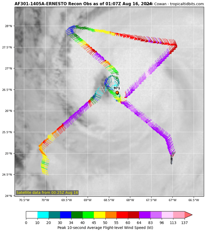
Second recon pass confirms winds are a lot more symmetrical. Extrapolated pressure 968.0 mb.
1 likes
TC naming lists: retirements and intensity
Most aggressive Advisory #1's in North Atlantic (cr. kevin for starting the list)
Most aggressive Advisory #1's in North Atlantic (cr. kevin for starting the list)

Re: ATL: ERNESTO - Hurricane - Discussion
Bermuda may get lucky if Ernesto keeps tracking with more of an easterly component.
Trough #1 is rolling east so if Ernesto doesn't roll that way he will miss and stall south of Bermuda.
Trough #1 is rolling east so if Ernesto doesn't roll that way he will miss and stall south of Bermuda.
0 likes
-
Category5Kaiju

- Category 5
- Posts: 4345
- Joined: Thu Dec 24, 2020 12:45 pm
- Location: Seattle during the summer, Phoenix during the winter
Re: ATL: ERNESTO - Hurricane - Discussion
A Category 2???? Before August 20???? 
Looks like 2013 really got thrown out--- oh wait, Beryl happened.
Looks like 2013 really got thrown out--- oh wait, Beryl happened.
4 likes
Unless explicitly stated, all information in my posts is based on my own opinions and observations. Tropical storms and hurricanes can be extremely dangerous. Refer to an accredited weather research agency or meteorologist if you need to make serious decisions regarding an approaching storm.
-
cheezyWXguy

- Category 5
- Posts: 6282
- Joined: Mon Feb 13, 2006 12:29 am
- Location: Dallas, TX
Re: ATL: ERNESTO - Hurricane - Discussion
I gotta be honest, I can’t make sense of this storm. The development of a much more symmetrical wind field strongly implies strengthening, and recon has observed this under the hood. But wow, the current appearance does not reflect that at all.
2 likes

Re: ATL: ERNESTO - Hurricane - Discussion
cheezyWXguy wrote:I gotta be honest, I can’t make sense of this storm. The development of a much more symmetrical wind field strongly implies strengthening, and recon has observed this under the hood. But wow, the current appearance does not reflect that at all.

This was a 115 mph Cat 3 (Bonnie in 1998) so satellite can definitely be deceiving, especially if there's a broad enough core.
0 likes
The above post is not official and should not be used as such. It is the opinion of the poster and may or may not be backed by sound meteorological data. It is not endorsed by any professional institution or storm2k.org. For official information, please refer to the NHC and NWS products.
Re: ATL: ERNESTO - Hurricane - Discussion
cheezyWXguy wrote:I gotta be honest, I can’t make sense of this storm. The development of a much more symmetrical wind field strongly implies strengthening, and recon has observed this under the hood. But wow, the current appearance does not reflect that at all.
Since the IR was actually looking decent when recon was there, I also have to wonder if intensification slowed or stopped again just after recon left (and after NHC raised it to a Cat 2 based on recon).
0 likes
TC naming lists: retirements and intensity
Most aggressive Advisory #1's in North Atlantic (cr. kevin for starting the list)
Most aggressive Advisory #1's in North Atlantic (cr. kevin for starting the list)
-
ElectricStorm

- Category 5
- Posts: 5152
- Age: 25
- Joined: Tue Aug 13, 2019 11:23 pm
- Location: Norman, OK
Re: ATL: ERNESTO - Hurricane - Discussion
Looks like another round of dry air issues. It's been awhile since I've seen a hurricane struggle this long with dry air. Might be the ugliest IR presentation I've ever seen for a Cat 2

3 likes
B.S Meteorology, University of Oklahoma '25
Please refer to the NHC, NWS, or SPC for official information.
Please refer to the NHC, NWS, or SPC for official information.
-
MarioProtVI
- Category 5
- Posts: 1038
- Age: 24
- Joined: Sun Sep 29, 2019 7:33 pm
- Location: New Jersey
Re: ATL: ERNESTO - Hurricane - Discussion
ElectricStorm wrote:Looks like another round of dry air issues. It's been awhile since I've seen a hurricane struggle this long with dry air. Might be the ugliest IR presentation I've ever seen for a Cat 2
https://i.imgur.com/hw2qUEZ.jpeg
Earl ‘98 wants a word
0 likes

Re: ATL: ERNESTO - Hurricane - Discussion
Since 1939 the wettest TC at Bermuda was in October of 1939, which produced 7.35”, which may be less than one would think. Thus the 6-12” amounts being forecasted by the NHC are quite ominous in relation to history:
https://en.m.wikipedia.org/wiki/Templat ... in_Bermuda
This very heavy rainfall risk is high due to a combo of expected slow movement nearby, large size, and (near) record warm SSTs possibly leading to extra high PWATs.
https://en.m.wikipedia.org/wiki/Templat ... in_Bermuda
This very heavy rainfall risk is high due to a combo of expected slow movement nearby, large size, and (near) record warm SSTs possibly leading to extra high PWATs.
3 likes
Personal Forecast Disclaimer:
The posts in this forum are NOT official forecasts and should not be used as such. They are just the opinion of the poster and may or may not be backed by sound meteorological data. They are NOT endorsed by any professional institution or storm2k.org. For official information, please refer to the NHC and NWS products.
The posts in this forum are NOT official forecasts and should not be used as such. They are just the opinion of the poster and may or may not be backed by sound meteorological data. They are NOT endorsed by any professional institution or storm2k.org. For official information, please refer to the NHC and NWS products.
-
Hurricane2022

- Category 5
- Posts: 2090
- Joined: Tue Aug 23, 2022 11:38 pm
- Location: Araçatuba, Brazil
Re: ATL: ERNESTO - Hurricane - Discussion
Looking good finally

0 likes
Sorry for the bad English sometimes...!
For reliable and detailed information for any meteorological phenomenon, please consult the National Hurricane Center, Joint Typhoon Warning Center , or your local Meteo Center.
--------
ECCE OMNIA NOVA FACIAM (Ap 21,5).
For reliable and detailed information for any meteorological phenomenon, please consult the National Hurricane Center, Joint Typhoon Warning Center , or your local Meteo Center.
--------
ECCE OMNIA NOVA FACIAM (Ap 21,5).

Re: ATL: ERNESTO - Hurricane - Discussion
ElectricStorm wrote:Looks like another round of dry air issues. It's been awhile since I've seen a hurricane struggle this long with dry air. Might be the ugliest IR presentation I've ever seen for a Cat 2
https://i.imgur.com/hw2qUEZ.jpeg
I guess the large size of Ernesto’s circulation makes it more susceptible to pulling in dry air. Plus there’s non-negligible amounts of shear, which should increase over the next 24 hours.
1 likes
Irene '11 Sandy '12 Hermine '16 5/15/2018 Derecho Fay '20 Isaias '20 Elsa '21 Henri '21 Ida '21
I am only a meteorology enthusiast who knows a decent amount about tropical cyclones. Look to the professional mets, the NHC, or your local weather office for the best information.
I am only a meteorology enthusiast who knows a decent amount about tropical cyclones. Look to the professional mets, the NHC, or your local weather office for the best information.
-
MEANINGLESS_NUMBERS
- Category 2

- Posts: 503
- Joined: Mon Nov 02, 2020 1:43 pm
Re: ATL: ERNESTO - Hurricane - Discussion
LarryWx wrote:Since 1939 the wettest TC at Bermuda was in October of 1939, which produced 7.35”, which may be less than one would think. Thus the 6-12” amounts being forecasted by the NHC are quite ominous in relation to history:
https://en.m.wikipedia.org/wiki/Templat ... in_Bermuda
This very heavy rainfall risk is high due to a combo of expected slow movement nearby, large size, and (near) record warm SSTs possibly leading to extra high PWATs.
Fortunately Bermuda is not particularly prone to flooding. We are all excited to fill our tanks.
2 likes
Emily '87, Felix '95, Gert '99, Fabian '03, Humberto '19, Paulette '20, Teddy '20, Fiona '22, Lee '23, Ernesto '24, Humberto/Imelda '25
-
MEANINGLESS_NUMBERS
- Category 2
- Posts: 503
- Joined: Mon Nov 02, 2020 1:43 pm
Re: ATL: ERNESTO - Hurricane - Discussion
LarryWx wrote:Kazmit wrote:Not strengthening very quickly but it has a large area of hurricane force winds to the east. Bermuda will have a decent stretch of 65kt+ winds. Luckily it shouldn’t be too bad as we are no stranger to direct cat 1-2 impacts- seems to occur every couple of years.
One thing that ACE and SS scale don’t reflect on well is diameter of strong winds/size of storm.
Use IKE! All my homies use IKE.
1 likes
Emily '87, Felix '95, Gert '99, Fabian '03, Humberto '19, Paulette '20, Teddy '20, Fiona '22, Lee '23, Ernesto '24, Humberto/Imelda '25
-
Hypercane_Kyle

- Category 5
- Posts: 3465
- Joined: Sat Mar 07, 2015 7:58 pm
- Location: Cape Canaveral, FL
Re: ATL: ERNESTO - Hurricane - Discussion
Dry air has been the bane of Ernesto's existence ever since it was a tropical wave.
0 likes
My posts are my own personal opinion, defer to the National Hurricane Center (NHC) and other NOAA products for decision making during hurricane season.
-
cheezyWXguy
- Category 5
- Posts: 6282
- Joined: Mon Feb 13, 2006 12:29 am
- Location: Dallas, TX
Re: ATL: ERNESTO - Hurricane - Discussion
Hypercane_Kyle wrote:Dry air has been the bane of Ernesto's existence ever since it was a tropical wave.
And yet it appears to be at least as strong as it was last night based on recon. Real head scratcher
0 likes

Re: ATL: ERNESTO - Hurricane - Discussion
From today’s 5 AM discussion:
However,
The environment near Ernesto could support some strengthening today.
However, the most noticeable change in the overnight intensity
guidance aids is that almost all of them are showing more shear
today than previously expected. This shear, combined with the
environmental dry air, has led to this cycle's intensity forecast
values being a lot lower than 6 h ago.
However, the most noticeable change in the overnight intensity
guidance aids is that almost all of them are showing more shear
today than previously expected. This shear, combined with the
environmental dry air, has led to this cycle's intensity forecast
values being a lot lower than 6 h ago.
However,
After the
hurricane passes Bermuda, there could be a brief window for some
re-intensification in lighter shear conditions plus favorable trough
influences before Ernesto crosses into cool waters.
hurricane passes Bermuda, there could be a brief window for some
re-intensification in lighter shear conditions plus favorable trough
influences before Ernesto crosses into cool waters.
0 likes
Kendall -> SLO -> PBC
Memorable Storms: Katrina (for its Florida landfall...) Wilma Matthew Irma
Memorable Storms: Katrina (for its Florida landfall...) Wilma Matthew Irma
Re: ATL: ERNESTO - Hurricane - Discussion
cheezyWXguy wrote:Hypercane_Kyle wrote:Dry air has been the bane of Ernesto's existence ever since it was a tropical wave.
And yet it appears to be at least as strong as it was last night based on recon. Real head scratcher
So just imagine what a monster it would be without that dry air intruding in his growth cycles!
Thank God for the dry air. I know Bermuda is glad.
3 likes
Cleo - 1964, Betsy - 1965, David - 1979, Andrew - 1992, Charlie (Francis, Ivan, Jeanne) - 2004, Irma - 2017, Ian - 2022, Milton - 2024
-
cycloneye

- Admin

- Posts: 149688
- Age: 69
- Joined: Thu Oct 10, 2002 10:54 am
- Location: San Juan, Puerto Rico
Re: ATL: ERNESTO - Hurricane - Discussion
0 likes
Visit the Caribbean-Central America Weather Thread where you can find at first post web cams,radars
and observations from Caribbean basin members Click Here
and observations from Caribbean basin members Click Here
Re: ATL: ERNESTO - Hurricane - Discussion
MEANINGLESS_NUMBERS wrote:LarryWx wrote:Since 1939 the wettest TC at Bermuda was in October of 1939, which produced 7.35”, which may be less than one would think. Thus the 6-12” amounts being forecasted by the NHC are quite ominous in relation to history:
https://en.m.wikipedia.org/wiki/Templat ... in_Bermuda
This very heavy rainfall risk is high due to a combo of expected slow movement nearby, large size, and (near) record warm SSTs possibly leading to extra high PWATs.
Fortunately Bermuda is not particularly prone to flooding. We are all excited to fill our tanks.
I’ve been there and learned about the roofs collecting water from rain:
https://www.thisoldhouse.com/bermuda-ho ... old%20taps.
0 likes
Personal Forecast Disclaimer:
The posts in this forum are NOT official forecasts and should not be used as such. They are just the opinion of the poster and may or may not be backed by sound meteorological data. They are NOT endorsed by any professional institution or storm2k.org. For official information, please refer to the NHC and NWS products.
The posts in this forum are NOT official forecasts and should not be used as such. They are just the opinion of the poster and may or may not be backed by sound meteorological data. They are NOT endorsed by any professional institution or storm2k.org. For official information, please refer to the NHC and NWS products.
Who is online
Users browsing this forum: No registered users and 86 guests