Euro completely dropped this AOI.
Edit: Massive downtick on 12z Euro ensembles vs 00z. Yeah this things getting its chances lowered at 8 lmao.
Tropical Wave in Bay of Campeche (Is Invest 91L)
Moderator: S2k Moderators
Forum rules

The posts in this forum are NOT official forecasts and should not be used as such. They are just the opinion of the poster and may or may not be backed by sound meteorological data. They are NOT endorsed by any professional institution or STORM2K. For official information, please refer to products from the National Hurricane Center and National Weather Service.
-
MarioProtVI
- Category 5

- Posts: 1032
- Age: 24
- Joined: Sun Sep 29, 2019 7:33 pm
- Location: New Jersey

Re: Disturbed weather in Central Atlantic (0/20)
MarioProtVI wrote:Euro completely dropped this AOI.
Edit: Massive downtick on 12z Euro ensembles vs 00z. Yeah this things getting its chances lowered at 8 lmao.
It’s a 20%, that’s an 80% chance of no development within 7 days. Still looking like roughly 20% of ensemble members onboard within 7 days on GEFS and EPS, so I suspect they will hold it for now.
3 likes
Kendall -> SLO -> PBC
Memorable Storms: Katrina (for its Florida landfall...) Wilma Matthew Irma
Memorable Storms: Katrina (for its Florida landfall...) Wilma Matthew Irma

Re: Disturbed weather in Central Atlantic (0/20)
MarioProtVI wrote:Euro completely dropped this AOI.
Edit: Massive downtick on 12z Euro ensembles vs 00z. Yeah this things getting its chances lowered at 8 lmao.
things are hostile out there in the atlantic!
1 likes

Re: Disturbed weather in Central Atlantic (0/20)
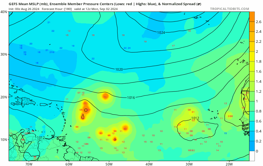
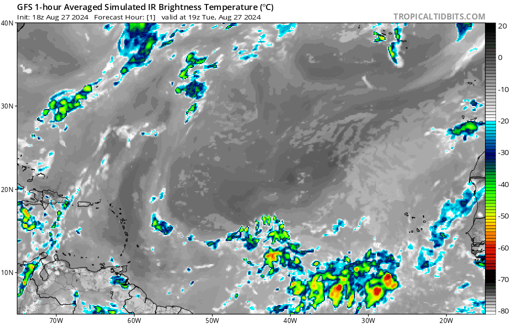
GEFS member low pressure counts (±2, out of 31):
There may be a little bit more than what meets the eye, though. On 12z GEFS, the members that do develop are by far more concentrated than earlier runs, with 4-5 strong members in a singular tight cluster near the Lesser Antilles here:
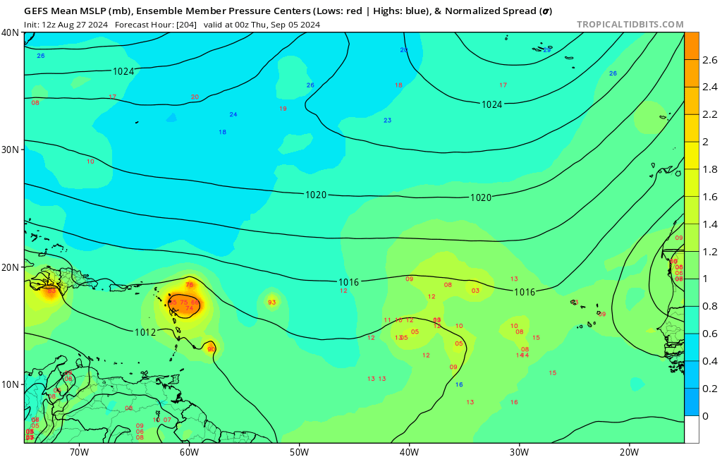
I did a bit of digging and traced it back to around 120-144 hrs. It appears that 12z GEFS is much slower but further south than previous runs - but that's still not all. Looks like since 0z 8/26 (when the uptick started), the ensemble members can be split into two clusters, the "west blob" and "east blob". On this run, the west blob only has 1 member that still has a TC, but support for the east blob seems virtually unchanged.
Why the difference between the two blobs, I don't know. Additionally, Euro ensembles are much further west at the same 144 hrs (with some members already in NE Caribbean), so such a distinction is nowhere close to being set in stone.
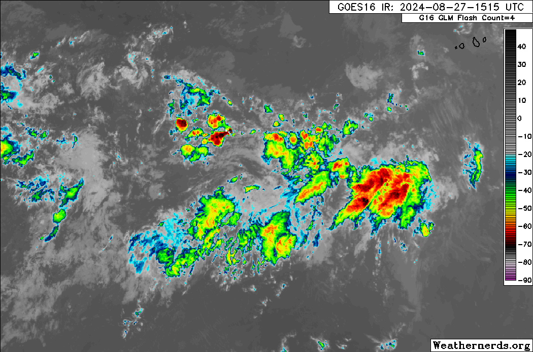
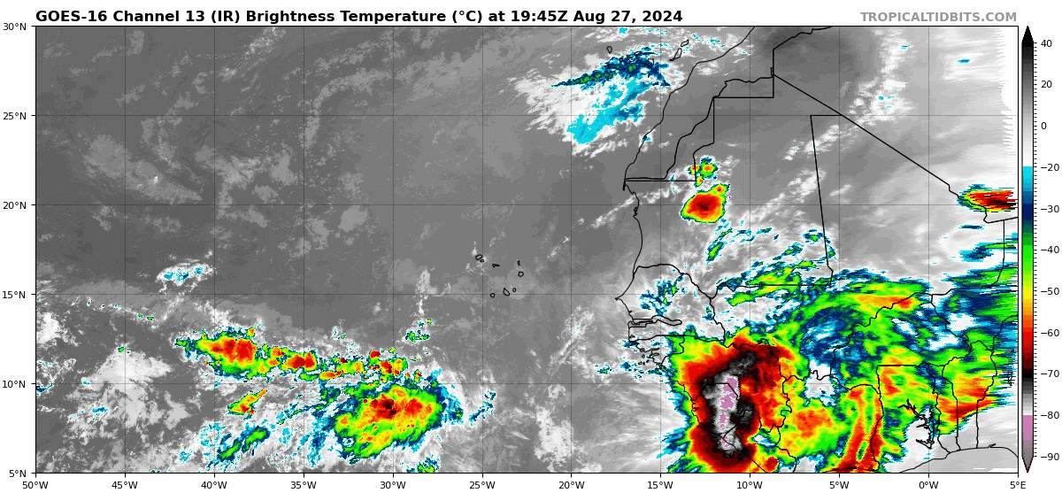
On the other hand, the current appearance of the disturbance does look like there are two lobes of convection stretched out E-W, with the eastern one being a bit more prominent. It also seems to have been able to sustain convection for longer than earlier discussions would make you believe, while looking more convectively active and less sheared than most disturbances in this region have been this season.
- 12z 8/27: 9 (29%)
- 6z 8/27: 14 (45%)
- 0z 8/27: 9 (29%)
- 18z 8/26: 19 (61%)
- 12z 8/26: 17 (55%)
- 6z 8/26: 19 (61%)
- 0z 8/26: 16 (52%)
- 18z 8/25: 10 (32%)
- 12z 8/25: 14 (45%)
- 12z 8/27: 14 (27%)
- 6z 8/27 (out to 144 hrs only): 20 (39%)
- 0z 8/27: 25 (49%)
- 18z 8/26 (out to 144 hrs only): 27 (53%)
- 12z 8/26: 34 (67%)
- 0z 8/26: 22 (43%)
- 12z 8/25: 11 (22%)
There may be a little bit more than what meets the eye, though. On 12z GEFS, the members that do develop are by far more concentrated than earlier runs, with 4-5 strong members in a singular tight cluster near the Lesser Antilles here:
I did a bit of digging and traced it back to around 120-144 hrs. It appears that 12z GEFS is much slower but further south than previous runs - but that's still not all. Looks like since 0z 8/26 (when the uptick started), the ensemble members can be split into two clusters, the "west blob" and "east blob". On this run, the west blob only has 1 member that still has a TC, but support for the east blob seems virtually unchanged.
Why the difference between the two blobs, I don't know. Additionally, Euro ensembles are much further west at the same 144 hrs (with some members already in NE Caribbean), so such a distinction is nowhere close to being set in stone.
On the other hand, the current appearance of the disturbance does look like there are two lobes of convection stretched out E-W, with the eastern one being a bit more prominent. It also seems to have been able to sustain convection for longer than earlier discussions would make you believe, while looking more convectively active and less sheared than most disturbances in this region have been this season.
9 likes
TC naming lists: retirements and intensity
Most aggressive Advisory #1's in North Atlantic (cr. kevin for starting the list)
Most aggressive Advisory #1's in North Atlantic (cr. kevin for starting the list)
-
MarioProtVI
- Category 5
- Posts: 1032
- Age: 24
- Joined: Sun Sep 29, 2019 7:33 pm
- Location: New Jersey
Re: Disturbed weather in Central Atlantic (0/20)
18z GFS and ensembles dropped this completely and now this practically has no model support anymore. Expect a lowering at 8 and removal pretty quickly by tomorrow.
0 likes
-
Iceresistance

- Category 5
- Posts: 9565
- Age: 22
- Joined: Sat Oct 10, 2020 9:45 am
- Location: Tecumseh, OK/Norman, OK
Re: Disturbed weather in Central Atlantic (0/20)
1 likes
Bill 2015 & Beta 2020
Winter 2020-2021
All observations are in Tecumseh, OK unless otherwise noted.
Winter posts are focused mainly for Oklahoma & Texas.
Take any of my forecasts with a grain of salt, refer to the NWS, SPC, and NHC for official information
Never say Never with weather! Because ANYTHING is possible!
Winter 2020-2021
All observations are in Tecumseh, OK unless otherwise noted.
Winter posts are focused mainly for Oklahoma & Texas.
Take any of my forecasts with a grain of salt, refer to the NWS, SPC, and NHC for official information
Never say Never with weather! Because ANYTHING is possible!
-
cycloneye

- Admin

- Posts: 149121
- Age: 69
- Joined: Thu Oct 10, 2002 10:54 am
- Location: San Juan, Puerto Rico
Re: Disturbed weather in Central Atlantic (0/20)
No change or best known as cut and paste.
Tropical Weather Outlook
NWS National Hurricane Center Miami FL
800 PM EDT Tue Aug 27 2024
For the North Atlantic...Caribbean Sea and the Gulf of Mexico:
Central Tropical Atlantic:
An area of low pressure could form in the central portion of the
Tropical Atlantic in a few days. Thereafter, environmental
conditions appear generally favorable for some slow development of
this system this weekend into early next week as it moves westward
to west-northwestward at 10 to 15 mph.
* Formation chance through 48 hours...low...near 0 percent.
* Formation chance through 7 days...low...20 percent.
$$
Forecaster Beven
3 likes
Visit the Caribbean-Central America Weather Thread where you can find at first post web cams,radars
and observations from Caribbean basin members Click Here
and observations from Caribbean basin members Click Here
-
WeatherBoy2000
- Category 1

- Posts: 459
- Joined: Mon Apr 10, 2023 9:29 am
Re: Disturbed weather in Central Atlantic (0/20)
MarioProtVI wrote:18z GFS and ensembles dropped this completely and now this practically has no model support anymore. Expect a lowering at 8 and removal pretty quickly by tomorrow.
They only have it 20% in seven days, the nhc is never very quick to remove AOIs like these because there's always the chance model support comes back around on them. I think it'll be at least another 12-24 hours before they decide to do anything.
1 likes
-
SconnieCane
- Category 5
- Posts: 1013
- Joined: Thu Aug 02, 2018 5:29 pm
- Location: Madison, WI
Re: Disturbed weather in Central Atlantic (0/20)
WeatherBoy2000 wrote:MarioProtVI wrote:18z GFS and ensembles dropped this completely and now this practically has no model support anymore. Expect a lowering at 8 and removal pretty quickly by tomorrow.
They only have it 20% in seven days, the nhc is never very quick to remove AOIs like these because there's always the chance model support comes back around on them. I think it'll be at least another 12-24 hours before they decide to do anything.
Yeah, if they bit on every model change they'd be constantly adding/removing AOIs and it'd be pointless.
2 likes
Re: Disturbed weather in Central Atlantic (0/20)
Convection has increased further as we head into the night. However, GFS seems to show this increase in convection on its recent runs, yet thinks it doesn't matter. We'll see.
I also wonder if the recent backing off is because the wave is overwhelmed by the one behind it.
I also wonder if the recent backing off is because the wave is overwhelmed by the one behind it.
1 likes
TC naming lists: retirements and intensity
Most aggressive Advisory #1's in North Atlantic (cr. kevin for starting the list)
Most aggressive Advisory #1's in North Atlantic (cr. kevin for starting the list)
-
cycloneye
- Admin
- Posts: 149121
- Age: 69
- Joined: Thu Oct 10, 2002 10:54 am
- Location: San Juan, Puerto Rico
Re: Disturbed weather in Central Atlantic (0/20)
0 likes
Visit the Caribbean-Central America Weather Thread where you can find at first post web cams,radars
and observations from Caribbean basin members Click Here
and observations from Caribbean basin members Click Here
Re: Disturbed weather in Central Atlantic (0/20)
Teban54 wrote:GEFS member low pressure counts (±2, out of 31):EPS member low pressure counts (±3, out of 51):
- 12z 8/27: 9 (29%)
- 6z 8/27: 14 (45%)
- 0z 8/27: 9 (29%)
- 18z 8/26: 19 (61%)
- 12z 8/26: 17 (55%)
- 6z 8/26: 19 (61%)
- 0z 8/26: 16 (52%)
- 18z 8/25: 10 (32%)
- 12z 8/25: 14 (45%)
- 12z 8/27: 14 (27%)
- 6z 8/27 (out to 144 hrs only): 20 (39%)
- 0z 8/27: 25 (49%)
- 18z 8/26 (out to 144 hrs only): 27 (53%)
- 12z 8/26: 34 (67%)
- 0z 8/26: 22 (43%)
- 12z 8/25: 11 (22%)
For record-keeping purposes:
- 18z GEFS: 4 (13%), a further drop from earlier runs (as others have noted)
- 18z EPS (out to 144 hrs only): 15 (29%), roughly similar to 12z
0 likes
TC naming lists: retirements and intensity
Most aggressive Advisory #1's in North Atlantic (cr. kevin for starting the list)
Most aggressive Advisory #1's in North Atlantic (cr. kevin for starting the list)
-
Stratton23
- Category 5
- Posts: 3476
- Joined: Fri Jul 21, 2023 10:59 pm
- Location: Katy, Tx
-
WaveBreaking

- Category 2

- Posts: 712
- Joined: Sun Jun 30, 2024 11:33 am
- Location: US
Re: Disturbed weather in Central Atlantic (0/20)
Looks better this morning

1 likes
I am NOT a professional meteorologist, so take all of my posts with a grain of salt. My opinions are mine and mine alone.

Re: Disturbed weather in Central Atlantic (0/20)
Operational global models are not thrilled this morning and have shifted focus to a wave coming off of Africa in about 4-5 days. However, the 00z ICON shows this wave making it into the Caribbean, so perhaps some development later is possible if it frees itself from the monsoon trough.
0 likes
Irene '11 Sandy '12 Hermine '16 5/15/2018 Derecho Fay '20 Isaias '20 Elsa '21 Henri '21 Ida '21
I am only a meteorology enthusiast who knows a decent amount about tropical cyclones. Look to the professional mets, the NHC, or your local weather office for the best information.
I am only a meteorology enthusiast who knows a decent amount about tropical cyclones. Look to the professional mets, the NHC, or your local weather office for the best information.
-
WaveBreaking
- Category 2
- Posts: 712
- Joined: Sun Jun 30, 2024 11:33 am
- Location: US
Re: Disturbed weather in Central Atlantic (0/20)
Hint of an MLC or a vort max this sunrise.

1 likes
I am NOT a professional meteorologist, so take all of my posts with a grain of salt. My opinions are mine and mine alone.
Re: Disturbed weather in Central Atlantic (0/20)
GEFS member low pressure counts (±2, out of 31):
Either way, there's still enough support to keep this at 20% for now.
- 6z 8/28: 9 (29%)
- 0z 8/28: 9 (29%)
- 18z 8/27: 4 (13%)
- 12z 8/27: 9 (29%)
- 6z 8/27: 14 (45%)
- 0z 8/27: 9 (29%)
- 18z 8/26: 19 (61%)
- 12z 8/26: 17 (55%)
- 6z 8/26: 19 (61%)
- 0z 8/26: 16 (52%)
- 18z 8/25: 10 (32%)
- 12z 8/25: 14 (45%)
- 6z 8/28 (out to 144 hrs only): 21 (41%, some may not be TCs)
- 0z 8/28: 11 (22%)
- 18z 8/27 (out to 144 hrs only): 15 (29%)
- 12z 8/27: 14 (27%)
- 6z 8/27 (out to 144 hrs only): 20 (39%)
- 0z 8/27: 25 (49%)
- 18z 8/26 (out to 144 hrs only): 27 (53%)
- 12z 8/26: 34 (67%)
- 0z 8/26: 22 (43%)
- 12z 8/25: 11 (22%)
Either way, there's still enough support to keep this at 20% for now.
Last edited by Teban54 on Wed Aug 28, 2024 8:30 am, edited 1 time in total.
2 likes
TC naming lists: retirements and intensity
Most aggressive Advisory #1's in North Atlantic (cr. kevin for starting the list)
Most aggressive Advisory #1's in North Atlantic (cr. kevin for starting the list)
-
TomballEd
- Category 5
- Posts: 1242
- Age: 62
- Joined: Wed Aug 16, 2023 4:52 pm
- Location: Spring/Klein area, not Tomball
Re: Disturbed weather in Central Atlantic (0/20)
Between this and remaining model support (see Tehan), this system is still worthy of a 7 day 20% lemon. That means 80% it never becomes a TC, I do think there is a chance it waits until the W. Caribbean to develop, which could make it a Gulf threat.
1 likes
-
AutoPenalti
- Category 5
- Posts: 4091
- Age: 29
- Joined: Mon Aug 17, 2015 4:16 pm
- Location: Ft. Lauderdale, Florida
Re: Disturbed weather in Central Atlantic (0/20)
This could be a case of models playing catch up to real time developments, seems to be failing at initializing the convection properly.
0 likes
The posts in this forum are NOT official forecasts and should not be used as such. They are just the opinion of the poster and may or may not be backed by sound meteorological data. They are NOT endorsed by any professional institution or STORM2K. For official information, please refer to products from the NHC and NWS.
Model Runs Cheat Sheet:
GFS (5:30 AM/PM, 11:30 AM/PM)
HWRF, GFDL, UKMET, NAVGEM (6:30-8:00 AM/PM, 12:30-2:00 AM/PM)
ECMWF (1:45 AM/PM)
TCVN is a weighted averaged
-
Stratton23
- Category 5
- Posts: 3476
- Joined: Fri Jul 21, 2023 10:59 pm
- Location: Katy, Tx
Re: Disturbed weather in Central Atlantic (0/20)
ICON 12z starts to develop this system again in the central caribbean with stout ridging to its north
0 likes