Tropical Wave in Bay of Campeche (Is Invest 91L)

This is the general tropical discussion area. Anyone can take their shot at predicting a storms path.

Moderator: S2k Moderators

Forum rules

The posts in this forum are NOT official forecasts and should not be used as such. They are just the opinion of the poster and may or may not be backed by sound meteorological data. They are NOT endorsed by any professional institution or STORM2K. For official information, please refer to products from the National Hurricane Center and National Weather Service.

Help Support Storm2K
Message
Author
User avatar
Ivanhater
Storm2k Moderator
Storm2k Moderator
Posts: 11153
Age: 38
Joined: Fri Jul 01, 2005 8:25 am
Location: Pensacola

Re: Tropical Wave east of Lesser Antilles (10/40)

#681 Postby Ivanhater » Sat Aug 31, 2024 7:02 pm

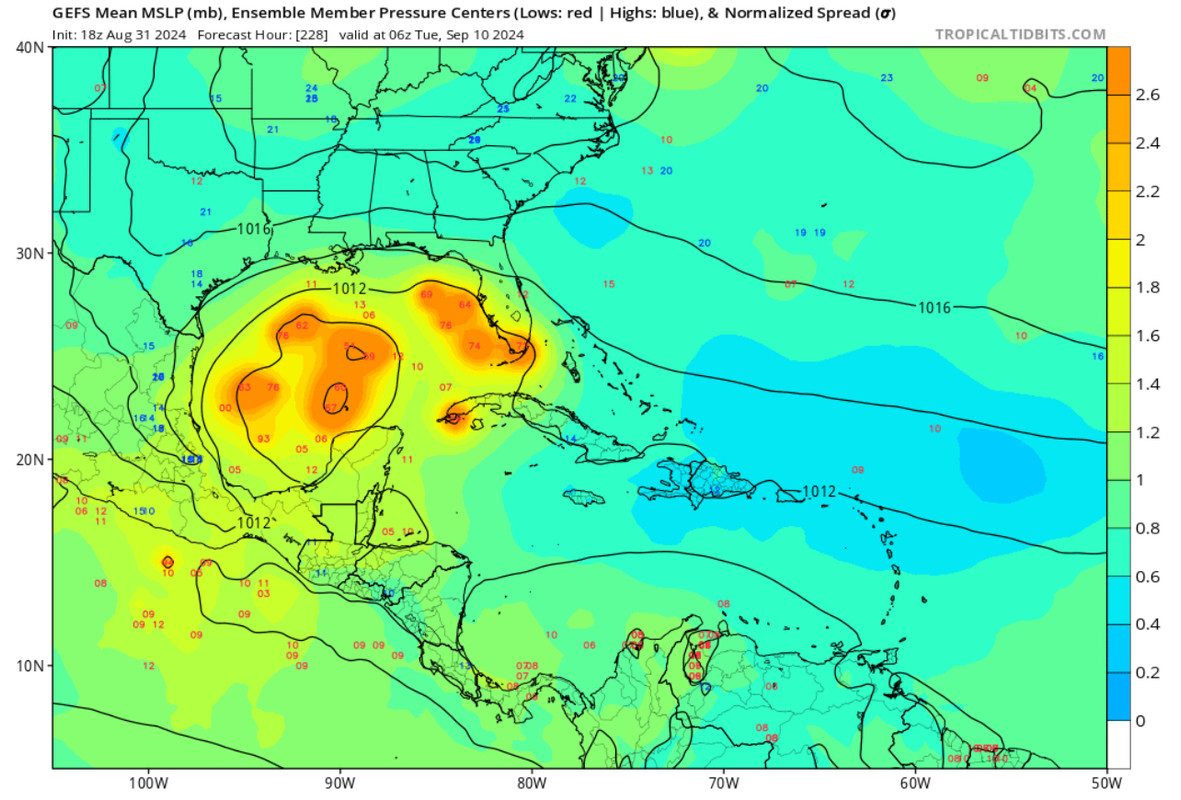
Ensembles mostly Louisiana to east of Florida
Image

Sent from my motorola razr plus 2023 using Tapatalk
0 likes   
Michael

User avatar
Nimbus
Category 5
Category 5
Posts: 5274
Joined: Mon Jul 19, 2004 10:54 am

Re: Tropical Wave east of Lesser Antilles (10/40)

#682 Postby Nimbus » Sat Aug 31, 2024 7:08 pm

Ivanhater wrote:Ensembles mostly Louisiana to east of Florida
https://uploads.tapatalk-cdn.com/20240901/01680edb4040a81eecd37df7f74f9900.jpg

Sent from my motorola razr plus 2023 using Tapatalk


Must be at least one scenario where the shear tracks it just west of Puerto Rico as a weak 985 system.
0 likes   

Stratton23
Category 5
Category 5
Posts: 2371
Joined: Fri Jul 21, 2023 10:59 pm
Location: Katy, Tx

Re: Tropical Wave east of Lesser Antilles (10/40)

#683 Postby Stratton23 » Sat Aug 31, 2024 7:12 pm

the entire gulf coast should be watching, will be interesting to see if the 00z Runs come in more aggressive
0 likes   

User avatar
Blown Away
S2K Supporter
S2K Supporter
Posts: 10140
Joined: Wed May 26, 2004 6:17 am

Re: Tropical Wave east of Lesser Antilles (10/40)

#684 Postby Blown Away » Sat Aug 31, 2024 7:15 pm

Image

If you consider the entire GOM as consistency, than 18z GEFS are correct. Flopping from MX, TX, LA, Panhandle, and throw in a few open wave runs, not very telling to me…
0 likes   
Hurricane Eye Experience: David 79, Irene 99, Frances 04, Jeanne 04, Wilma 05... EYE COMING MY WAY IN 2024…
Hurricane Brush Experience: Andrew 92, Erin 95, Floyd 99, Matthew 16, Irma 17, Ian 22, Nicole 22…

User avatar
Teban54
Category 5
Category 5
Posts: 3168
Joined: Sat May 19, 2018 1:19 pm

Re: Tropical Wave east of Lesser Antilles (10/40)

#685 Postby Teban54 » Sat Aug 31, 2024 7:17 pm

Tropical Tidbits has loaded 18z EC-Fast out to 72 hrs. It doesn't look like the system is notably better organized than 12z Euro, but EC-Fast does have lower resolution that make the vorticity more washed out than the full-res runs would suggest. Without having access to the full run myself, I'd guess it would show vorticity a hair better than 12z, but nothing compared to the drastic difference between 18z and 12z GFS.

I wouldn't say being weak in the Caribbean rules out a strong hurricane in the Gulf, though. Recent model runs seem to suggest that if the system emerges over the Gulf as a coherent TC (even just a TS), it will bomb out. Scenarios in which this doesn't happen include if a TC still had not formed by the time it enters the Gulf, or if the system gets pushed west and crashes into Central America (low intensity can result in this, but so can a strong ridge). However, neither precludes a mid-range TS from entering the Gulf on a NW track and intensifying, even if the starting point isn't nearly as high as 18z GFS.
0 likes   

User avatar
Ivanhater
Storm2k Moderator
Storm2k Moderator
Posts: 11153
Age: 38
Joined: Fri Jul 01, 2005 8:25 am
Location: Pensacola

Re: Tropical Wave east of Lesser Antilles (10/40)

#686 Postby Ivanhater » Sat Aug 31, 2024 7:20 pm

Blown Away wrote:[url]https://i.postimg.cc/jjRTdsxp/IMG-0032.jpg [/url]

If you consider the entire GOM as consistency, than 18z GEFS are correct. Flopping from MX, TX, LA, Panhandle, and throw in a few open wave runs, not very telling to me…

Well, if you look deeper into it, the Mexico and Texas solutions are either not developing or not developing until after the Yucatan.

The Louisiana to Florida are for the runs that develop when it's stronger in the Caribbean. The upper level pattern has been pretty consistent. The question of which solution pans out is how early/late it develops
1 likes   
Michael

User avatar
Blown Away
S2K Supporter
S2K Supporter
Posts: 10140
Joined: Wed May 26, 2004 6:17 am

Re: Tropical Wave east of Lesser Antilles (10/40)

#687 Postby Blown Away » Sat Aug 31, 2024 7:20 pm

Image

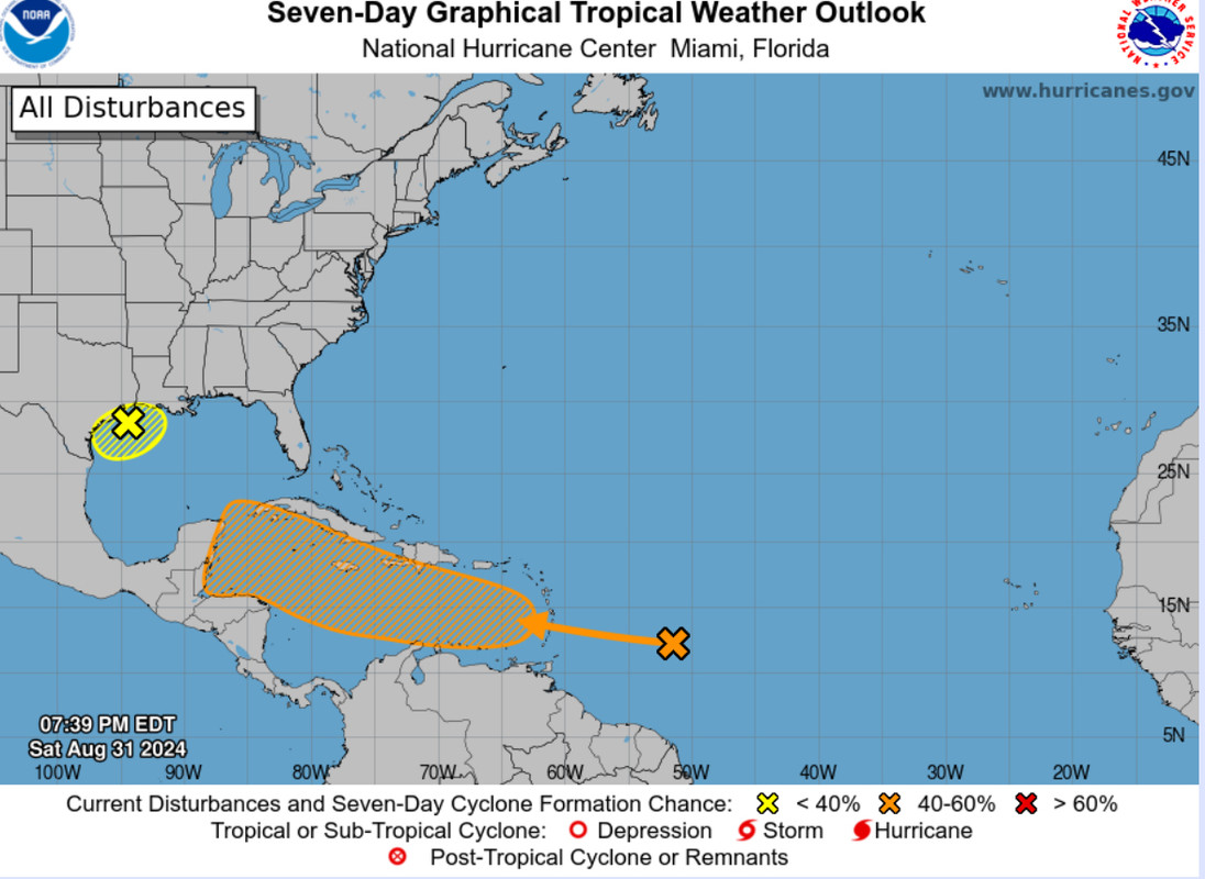
At 8pm update, the NHC did expand their cone E and N again, so the 18z GFS run is being considered IMO…
1 likes   
Hurricane Eye Experience: David 79, Irene 99, Frances 04, Jeanne 04, Wilma 05... EYE COMING MY WAY IN 2024…
Hurricane Brush Experience: Andrew 92, Erin 95, Floyd 99, Matthew 16, Irma 17, Ian 22, Nicole 22…

Frank P
S2K Supporter
S2K Supporter
Posts: 2772
Joined: Fri Aug 29, 2003 10:52 am
Location: Biloxi Beach, Ms
Contact:

Re: Tropical Wave east of Lesser Antilles (10/40)

#688 Postby Frank P » Sat Aug 31, 2024 7:24 pm

here are the 18Z GFS ensembles at hour 240.
Image
1 likes   

User avatar
Steve
S2K Supporter
S2K Supporter
Posts: 9591
Joined: Sat Apr 05, 2003 11:41 pm
Location: Not a state-caster

Re: Tropical Wave east of Lesser Antilles (10/40)

#689 Postby Steve » Sat Aug 31, 2024 7:34 pm

Blown Away wrote:[url]https://i.postimg.cc/jjRTdsxp/IMG-0032.jpg [/url]

If you consider the entire GOM as consistency, than 18z GEFS are correct. Flopping from MX, TX, LA, Panhandle, and throw in a few open wave runs, not very telling to me…


That’s valid for a week from next Tuesday.
1 likes   

LarryWx
Category 5
Category 5
Posts: 6246
Joined: Sun Sep 07, 2003 2:04 pm
Location: GA

Re: Tropical Wave east of Lesser Antilles (10/40)

#690 Postby LarryWx » Sat Aug 31, 2024 7:51 pm

Teban54 wrote:Tropical Tidbits has loaded 18z EC-Fast out to 72 hrs. It doesn't look like the system is notably better organized than 12z Euro, but EC-Fast does have lower resolution that make the vorticity more washed out than the full-res runs would suggest. Without having access to the full run myself, I'd guess it would show vorticity a hair better than 12z, but nothing compared to the drastic difference between 18z and 12z GFS.

I wouldn't say being weak in the Caribbean rules out a strong hurricane in the Gulf, though. Recent model runs seem to suggest that if the system emerges over the Gulf as a coherent TC (even just a TS), it will bomb out. Scenarios in which this doesn't happen include if a TC still had not formed by the time it enters the Gulf, or if the system gets pushed west and crashes into Central America (low intensity can result in this, but so can a strong ridge). However, neither precludes a mid-range TS from entering the Gulf on a NW track and intensifying, even if the starting point isn't nearly as high as 18z GFS.


The 18Z EPS mean at 144 (end) in the W Car is fwiw a bit weaker than the 12Z 150 and is the weakest of today’s runs for that time.
0 likes   
Personal Forecast Disclaimer:
The posts in this forum are NOT official forecasts and should not be used as such. They are just the opinion of the poster and may or may not be backed by sound meteorological data. They are NOT endorsed by any professional institution or storm2k.org. For official information, please refer to the NHC and NWS products.

User avatar
gatorcane
S2K Supporter
S2K Supporter
Posts: 23689
Age: 47
Joined: Sun Mar 13, 2005 3:54 pm
Location: Boca Raton, FL

Re: Tropical Wave east of Lesser Antilles (10/40)

#691 Postby gatorcane » Sat Aug 31, 2024 8:03 pm

The GFS has it suddenly consolidating in the Eastern Caribbean which seems unlikely. That area is typically hostile for development due to easterly trades and inflow inhibited due to close proximity to South America, unless a system is already formed prior to entering that region.
0 likes   

User avatar
AtlanticWind
S2K Supporter
S2K Supporter
Posts: 1885
Age: 66
Joined: Sun Aug 08, 2004 9:57 pm
Location: Plantation,Fla

Re: Tropical Wave east of Lesser Antilles (10/40)

#692 Postby AtlanticWind » Sat Aug 31, 2024 8:16 pm

This is a spot (between 50 and 60 w) waves can quickly burst convection which
I think could change the model outputs over the next 24 hours or so.
3 likes   

User avatar
Teban54
Category 5
Category 5
Posts: 3168
Joined: Sat May 19, 2018 1:19 pm

Re: Tropical Wave east of Lesser Antilles (10/40)

#693 Postby Teban54 » Sat Aug 31, 2024 8:21 pm

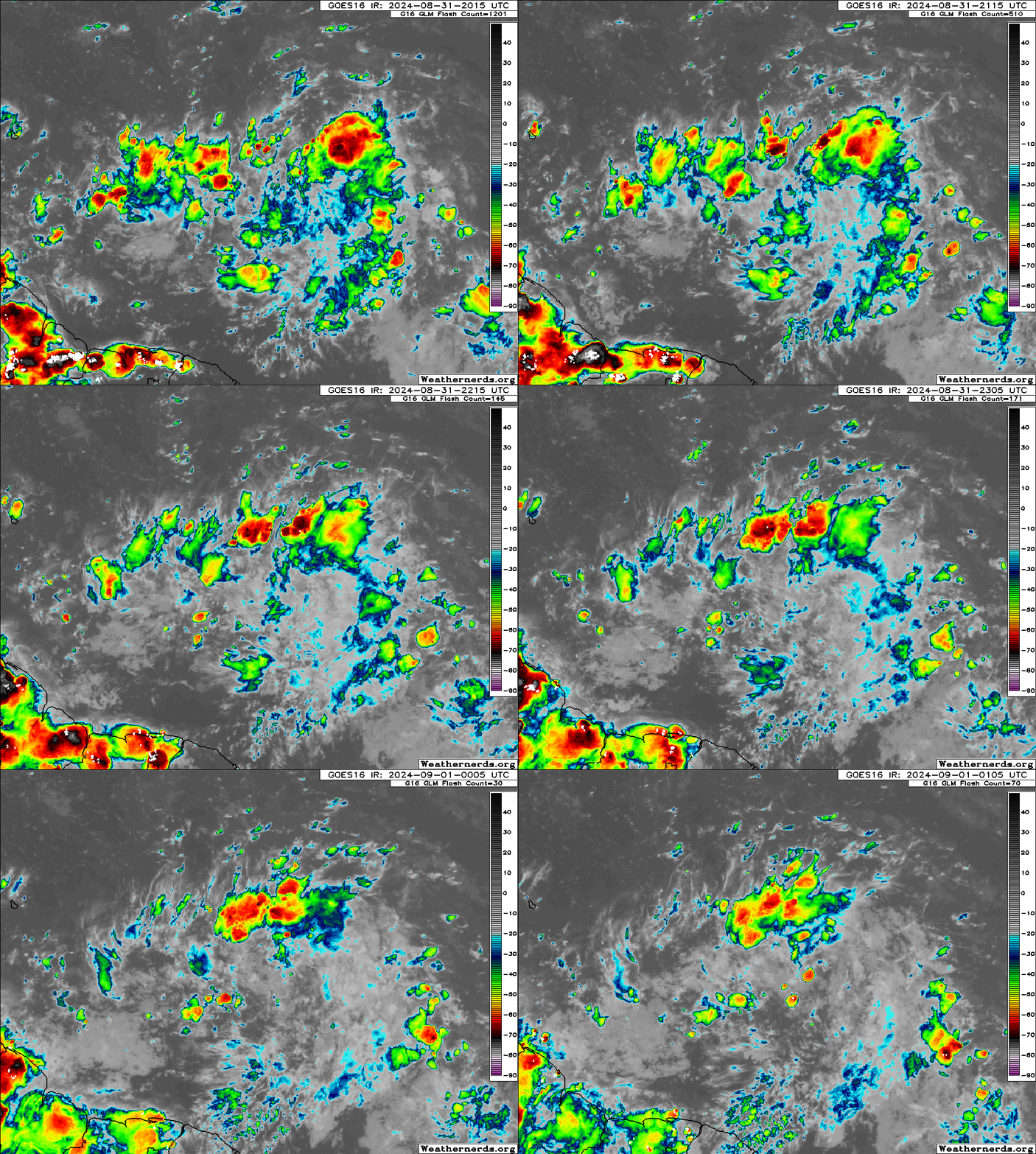
There hasn't been a lot of convection so far tonight, but the ones that did fire (especially to the north) are now actually rotating around the center for the first time, instead of just being a disorganized mess. Also, the competing vorts seem to be almost gone.

Image
0 likes   

869MB
S2K Supporter
S2K Supporter
Posts: 157
Joined: Thu Feb 14, 2019 9:49 pm
Location: Katy, TX

Re: Tropical Wave east of Lesser Antilles (10/40)

#694 Postby 869MB » Sat Aug 31, 2024 8:35 pm

3 likes   

User avatar
Teban54
Category 5
Category 5
Posts: 3168
Joined: Sat May 19, 2018 1:19 pm

Re: Tropical Wave east of Lesser Antilles (10/40)

#695 Postby Teban54 » Sat Aug 31, 2024 9:37 pm

:uarrow: Sounds like the difference between the stronger/weaker tracks mostly has to do with short-term organization (aside from model biases):
 https://x.com/DCAreaWx/status/1830058845789413772


A lot of the uncertainty regarding our monsoon trough-embedded wave stems from the fact that the low-levels become less favorable for TC genesis in a couple days. The upper-levels are rather favorable, however. This creates an “all or nothing” type scenario, where if we get TCG in the next few days, the ceiling for it should be pretty high as a vortex will be present. If not, then a vortex will struggle to close off for a while (Caribbean trades).
0 likes   

User avatar
chaser1
S2K Supporter
S2K Supporter
Posts: 5407
Age: 64
Joined: Sat Oct 15, 2005 5:59 pm
Location: Longwood, Fl

Re: Tropical Wave east of Lesser Antilles (10/40)

#696 Postby chaser1 » Sat Aug 31, 2024 10:18 pm

Show me the money 'cuz I'm still not seeing it :lol:

1) Is it slightly better organized? Perhaps but it's nominal organization lacks consistency.
2) CDO? :lol: Hardly any Central co-located convection (to say nothing about persistence of convection.
3) Model support? Not the type I'm looking for. Show me 4 GFS model runs minimumly depicting a TD in the Caribbean, and one or more other corroborating global model output for it to mean something.

Tomorrow it may prove its worth its NHC 50% chance of development- or it could go poof :cheesy:
0 likes   
Andy D

(For official information, please refer to the NHC and NWS products.)

User avatar
Teban54
Category 5
Category 5
Posts: 3168
Joined: Sat May 19, 2018 1:19 pm

Re: Tropical Wave east of Lesser Antilles (10/40)

#697 Postby Teban54 » Sat Aug 31, 2024 10:26 pm

chaser1 wrote:Show me the money 'cuz I'm still not seeing it :lol:

1) Is it slightly better organized? Perhaps but it's nominal organization lacks consistency.
2) CDO? :lol: Hardly any Central co-located convection (to say nothing about persistence of convection.
3) Model support? Not the type I'm looking for. Show me 4 GFS model runs minimumly depicting a TD in the Caribbean, and one or more other corroborating global model output for it to mean something.

Tomorrow it may prove its worth its NHC 50% chance of development- or it could go poof :cheesy:

There's a reason why the 50% chance of development is for 7 days and not 2 days. They don't expect it to blow up into a TD just yet, and in fact that scenario is only given a 10% chance.

Meanwhile, its 500 mb vorticity is already showing a clear improvement from 6-12 hours ago, now clearly being a single lobe that's stacked at all levels, which is something that can't be said over the past 2 days. Models do seem to think the vorticity will open back up once the system starts accelerating to the west, but we'll see.
0 likes   

User avatar
cycloneye
Admin
Admin
Posts: 143871
Age: 68
Joined: Thu Oct 10, 2002 10:54 am
Location: San Juan, Puerto Rico

Re: Tropical Wave east of Lesser Antilles (10/40)

#698 Postby cycloneye » Sat Aug 31, 2024 10:30 pm

0 likes   
Visit the Caribbean-Central America Weather Thread where you can find at first post web cams,radars
and observations from Caribbean basin members Click Here

mantis83
Tropical Storm
Tropical Storm
Posts: 198
Joined: Fri Dec 05, 2003 4:47 pm

Re: Tropical Wave east of Lesser Antilles (10/40)

#699 Postby mantis83 » Sat Aug 31, 2024 10:34 pm

0Z icon says nope, nothing to see here......
0 likes   

Stratton23
Category 5
Category 5
Posts: 2371
Joined: Fri Jul 21, 2023 10:59 pm
Location: Katy, Tx

Re: Tropical Wave east of Lesser Antilles (10/40)

#700 Postby Stratton23 » Sat Aug 31, 2024 10:41 pm

Mantis83 uh yeah no, this is definitely a troll comment, the ICON absolutely has something, a closed low developing in the western caribbean
2 likes   


Return to “Talkin' Tropics”

Who is online

Users browsing this forum: Sciencerocks and 129 guests