Frank P wrote:Any other year I would place money on that sat image developing in the GOM, and if you were to show me this image before August 10th, I would have placed big money, especially in the year that was forecast to be extremely active. But since Ernesto nothing has been able to spin up anywhere: nada, zip, zero, niente. Strange times indeed mama... I am leaning towards nothing legit being named out of either of these systems...
Area of disturbed weather in NW Gulf of Mexico (Is Invest 90L)
Moderator: S2k Moderators
Forum rules

The posts in this forum are NOT official forecasts and should not be used as such. They are just the opinion of the poster and may or may not be backed by sound meteorological data. They are NOT endorsed by any professional institution or STORM2K. For official information, please refer to products from the National Hurricane Center and National Weather Service.
-
Stormcenter
- S2K Supporter

- Posts: 6689
- Joined: Wed Sep 03, 2003 11:27 am
- Location: Houston, TX
Re: Area of disturbed weather in NW Gulf of Mexico (10/10)
Exactly!!!!
1 likes

Re: Area of disturbed weather in NW Gulf of Mexico (0/0)
The 0Z UKMET is the first run with a TCG in the NW GOM but not til Fri evening similar to ICON timing: gets to TS strength, meanders around, and then moves NNE into SE LA Mon AM (I’d ignore the strength then as it’s usually too weak):
NEW TROPICAL CYCLONE FORECAST TO DEVELOP AFTER 96 HOURS
FORECAST POSITION AT T+ 96 : 27.8N 93.5W
LEAD CENTRAL MAXIMUM WIND
VERIFYING TIME TIME POSITION PRESSURE (MB) SPEED (KNOTS)
-------------- ---- -------- ------------- -------------
0000UTC 07.09.2024 96 27.8N 93.5W 1004 35
1200UTC 07.09.2024 108 26.4N 92.8W 1003 38
0000UTC 08.09.2024 120 26.8N 91.9W 1003 35
1200UTC 08.09.2024 132 26.3N 91.9W 1004 35
0000UTC 09.09.2024 144 27.6N 90.3W 1006 33
1200UTC 09.09.2024 156 30.2N 89.6W 1009 30
0000UTC 10.09.2024 168 CEASED TRACKING
0 likes
Personal Forecast Disclaimer:
The posts in this forum are NOT official forecasts and should not be used as such. They are just the opinion of the poster and may or may not be backed by sound meteorological data. They are NOT endorsed by any professional institution or storm2k.org. For official information, please refer to the NHC and NWS products.
The posts in this forum are NOT official forecasts and should not be used as such. They are just the opinion of the poster and may or may not be backed by sound meteorological data. They are NOT endorsed by any professional institution or storm2k.org. For official information, please refer to the NHC and NWS products.

Re: Area of disturbed weather in NW Gulf of Mexico (0/0)
LarryWx wrote:The 0Z UKMET is the first run with a TCG in the NW GOM but not til Fri evening similar to ICON timing: gets to TS strength, meanders around, and then moves NNE into SE LA Mon AM (I’d ignore the strength then as it’s usually too weak):
NEW TROPICAL CYCLONE FORECAST TO DEVELOP AFTER 96 HOURS
FORECAST POSITION AT T+ 96 : 27.8N 93.5W
LEAD CENTRAL MAXIMUM WIND
VERIFYING TIME TIME POSITION PRESSURE (MB) SPEED (KNOTS)
-------------- ---- -------- ------------- -------------
0000UTC 07.09.2024 96 27.8N 93.5W 1004 35
1200UTC 07.09.2024 108 26.4N 92.8W 1003 38
0000UTC 08.09.2024 120 26.8N 91.9W 1003 35
1200UTC 08.09.2024 132 26.3N 91.9W 1004 35
0000UTC 09.09.2024 144 27.6N 90.3W 1006 33
1200UTC 09.09.2024 156 30.2N 89.6W 1009 30
0000UTC 10.09.2024 168 CEASED TRACKING
Notable the UKMET is finally developing something, the NAM is showing something as well around the same time, and if something IS going to form in the Gulf, watching this for trends can be an early indicator
Seems like this (and the UKMET's system) is from the system that was over the Bahamas a few days ago

1 likes
The above post is not official and should not be used as such. It is the opinion of the poster and may or may not be backed by sound meteorological data. It is not endorsed by any professional institution or storm2k.org. For official information, please refer to the NHC and NWS products.
-
Frank P
- S2K Supporter
- Posts: 2779
- Joined: Fri Aug 29, 2003 10:52 am
- Location: Biloxi Beach, Ms
- Contact:
Re: Area of disturbed weather in NW Gulf of Mexico (0/0)
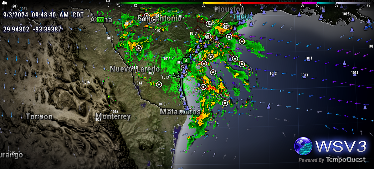
Radar loop of system in west GOM. Tap image for loop

0 likes

-
tropicwatch

- Category 5

- Posts: 3426
- Age: 62
- Joined: Sat Jun 02, 2007 10:01 am
- Location: Panama City Florida
- Contact:
Re: Area of disturbed weather in NW Gulf of Mexico (0/0)
Thinking the NHC might highlight the Gulf of Mexico again.
1 likes
Tropicwatch
Agnes 72', Eloise 75, Elena 85', Kate 85', Charley 86', Florence 88', Beryl 94', Dean 95', Erin 95', Opal 95', Earl 98', Georges 98', Ivan 2004', Arlene 2005', Dennis 2005', Ida 2009' Debby 2012' Irma 2017' Michael 2018'
Agnes 72', Eloise 75, Elena 85', Kate 85', Charley 86', Florence 88', Beryl 94', Dean 95', Erin 95', Opal 95', Earl 98', Georges 98', Ivan 2004', Arlene 2005', Dennis 2005', Ida 2009' Debby 2012' Irma 2017' Michael 2018'
Re: Area of disturbed weather in NW Gulf of Mexico (0/0)
Hammy wrote:LarryWx wrote:The 0Z UKMET is the first run with a TCG in the NW GOM but not til Fri evening similar to ICON timing: gets to TS strength, meanders around, and then moves NNE into SE LA Mon AM (I’d ignore the strength then as it’s usually too weak):
NEW TROPICAL CYCLONE FORECAST TO DEVELOP AFTER 96 HOURS
FORECAST POSITION AT T+ 96 : 27.8N 93.5W
LEAD CENTRAL MAXIMUM WIND
VERIFYING TIME TIME POSITION PRESSURE (MB) SPEED (KNOTS)
-------------- ---- -------- ------------- -------------
0000UTC 07.09.2024 96 27.8N 93.5W 1004 35
1200UTC 07.09.2024 108 26.4N 92.8W 1003 38
0000UTC 08.09.2024 120 26.8N 91.9W 1003 35
1200UTC 08.09.2024 132 26.3N 91.9W 1004 35
0000UTC 09.09.2024 144 27.6N 90.3W 1006 33
1200UTC 09.09.2024 156 30.2N 89.6W 1009 30
0000UTC 10.09.2024 168 CEASED TRACKING
Notable the UKMET is finally developing something, the NAM is showing something as well around the same time, and if something IS going to form in the Gulf, watching this for trends can be an early indicator
Seems like this (and the UKMET's system) is from the system that was over the Bahamas a few days ago
https://i.imgur.com/3MKoI9J.png
ICON (12Z) once again has this but not 12Z UKMET.
0 likes
Personal Forecast Disclaimer:
The posts in this forum are NOT official forecasts and should not be used as such. They are just the opinion of the poster and may or may not be backed by sound meteorological data. They are NOT endorsed by any professional institution or storm2k.org. For official information, please refer to the NHC and NWS products.
The posts in this forum are NOT official forecasts and should not be used as such. They are just the opinion of the poster and may or may not be backed by sound meteorological data. They are NOT endorsed by any professional institution or storm2k.org. For official information, please refer to the NHC and NWS products.
-
Stratton23
- Category 5
- Posts: 3517
- Joined: Fri Jul 21, 2023 10:59 pm
- Location: Katy, Tx
Re: Area of disturbed weather in NW Gulf of Mexico (0/0)
Nearly all of the 12z mesoscale models have this becoming a TS, and stalling around matagorda bay
0 likes
-
wxman57

- Moderator-Pro Met

- Posts: 23171
- Age: 68
- Joined: Sat Jun 21, 2003 8:06 pm
- Location: Houston, TX (southwest)
Re: Area of disturbed weather in NW Gulf of Mexico (0/0)
Last week, the ICON had a low developing on a cold front off the TX coast today. Nope. Now it's maybe next week. Probably not.
1 likes
-
Stratton23
- Category 5
- Posts: 3517
- Joined: Fri Jul 21, 2023 10:59 pm
- Location: Katy, Tx
Re: Area of disturbed weather in NW Gulf of Mexico (0/0)
wxman57 I disagree, the ICON has support
0 likes
-
wxman57
- Moderator-Pro Met
- Posts: 23171
- Age: 68
- Joined: Sat Jun 21, 2003 8:06 pm
- Location: Houston, TX (southwest)
Re: Area of disturbed weather in NW Gulf of Mexico (0/0)
Stratton23 wrote:wxman57 I disagree, the ICON has support
Yeah, as it did last week for today's storm. I'll believe it when I see it.
2 likes

Re: Area of disturbed weather in NW Gulf of Mexico (0/0)
wxman57 wrote:Stratton23 wrote:wxman57 I disagree, the ICON has support
Yeah, as it did last week for today's storm. I'll believe it when I see it.
It got the area right just not the intensity. I haven’t seen but part of the 12z EC run so far. Looked like ICON and EC 00z merges energy from the coastal low and wave moving in spinning in the Bay of Campeche before coming back up. Still not sure if they aren’t handling multiple areas right or if it’s a signal.
0 likes
-
Stratton23
- Category 5
- Posts: 3517
- Joined: Fri Jul 21, 2023 10:59 pm
- Location: Katy, Tx
Re: Area of disturbed weather in NW Gulf of Mexico (0/0)
18z HRRR looks to have a TS stalling just to the SW of galveston in 48 hours
1 likes
Re: Area of disturbed weather in NW Gulf of Mexico (0/0)
wxman57 wrote:Stratton23 wrote:wxman57 I disagree, the ICON has support
Yeah, as it did last week for today's storm. I'll believe it when I see it.
Apparently this has UKMET support too, and that's been the most conservative model this season
1 likes
The above post is not official and should not be used as such. It is the opinion of the poster and may or may not be backed by sound meteorological data. It is not endorsed by any professional institution or storm2k.org. For official information, please refer to the NHC and NWS products.

Re: Area of disturbed weather in NW Gulf of Mexico (0/0)
wxman57 wrote:Stratton23 wrote:wxman57 I disagree, the ICON has support
Yeah, as it did last week for today's storm. I'll believe it when I see it.
agreed. can't trust the icon.....
0 likes

Re: Area of disturbed weather in NW Gulf of Mexico (0/0)
I think anything is possible with that low pressure in the Gulf of Mexico.
0 likes
-
Stratton23
- Category 5
- Posts: 3517
- Joined: Fri Jul 21, 2023 10:59 pm
- Location: Katy, Tx
Re: Area of disturbed weather in NW Gulf of Mexico (0/0)
What in the blue blazes is the 00z NAM 3k doing?
0 likes
Re: Area of disturbed weather in NW Gulf of Mexico (0/0)
Stratton23 wrote:What in the blue blazes is the 00z NAM 3k doing?
Just your everyday strong TS/borderline Cat 1 crawling along the upper tx coast
0 likes
Re: Area of disturbed weather in NW Gulf of Mexico (0/0)
mantis83 wrote:wxman57 wrote:Stratton23 wrote:wxman57 I disagree, the ICON has support
Yeah, as it did last week for today's storm. I'll believe it when I see it.
agreed. can't trust the icon.....
I think if you look at it vis a vis 2024 NW Gulf it’s maybe been the best model. It stuck with Texas coastal low pressure and primarily offshore rains with some inches here and there. Intensity never got to much but the low has been there for a few days and it’s got it buried in the BoC merging with that wave energy in 5 days via 18z. I can’t find the 00z yet but see what it does. Beryl goes without saying.
2 likes
Who is online
Users browsing this forum: gib, mixedDanilo.E and 87 guests