ATL: FRANCINE - Remnants - Discussion
Moderator: S2k Moderators
-
ElectricStorm

- Category 5

- Posts: 5153
- Age: 25
- Joined: Tue Aug 13, 2019 11:23 pm
- Location: Norman, OK
Re: ATL: FRANCINE - Hurricane - Discussion
86kt FL in eastern quad. SFMR a little low but you could probably justify an increase to 70kts. 0.9 FL reduction would support 75kts
Last edited by ElectricStorm on Tue Sep 10, 2024 9:58 pm, edited 1 time in total.
2 likes
B.S Meteorology, University of Oklahoma '25
Please refer to the NHC, NWS, or SPC for official information.
Please refer to the NHC, NWS, or SPC for official information.
-
CrazyC83
- Professional-Met

- Posts: 34316
- Joined: Tue Mar 07, 2006 11:57 pm
- Location: Deep South, for the first time!
Re: ATL: FRANCINE - Hurricane - Discussion
The SFMR has not yet responded, but if it does, that would support 75-80 kt.
1 likes

Re: ATL: FRANCINE - Hurricane - Discussion
otowntiger wrote:CrazyC83 wrote:The Mexican Plateau's dry air may have made a big difference all along - without it, who knows what we would be dealing with now. I know quite a few storms have weakened in that area upon approach too due to dry air.
Yes- it appears that this storm is struggling and just barely made it to hurricane status. Sure, I didn’t think it would make it. Hopefully this is as strong as it gets before it begins succumbing to the forecasted upcoming shear before landfall.
And a whole 20 minutes later, the "struggling" Francine managed to strengthen past the "barely hurricane" status by at least 5 kts, if not more.
4 likes
TC naming lists: retirements and intensity
Most aggressive Advisory #1's in North Atlantic (cr. kevin for starting the list)
Most aggressive Advisory #1's in North Atlantic (cr. kevin for starting the list)
-
Hypercane_Kyle

- Category 5
- Posts: 3465
- Joined: Sat Mar 07, 2015 7:58 pm
- Location: Cape Canaveral, FL
Re: ATL: FRANCINE - Hurricane - Discussion
Definitely going to be an interesting night with this one... might make it past the border of Cat 2 overnight based on that recon pass.

2 likes
My posts are my own personal opinion, defer to the National Hurricane Center (NHC) and other NOAA products for decision making during hurricane season.
-
ElectricStorm
- Category 5
- Posts: 5153
- Age: 25
- Joined: Tue Aug 13, 2019 11:23 pm
- Location: Norman, OK
Re: ATL: FRANCINE - Hurricane - Discussion
Drop 980/12 supports 979mb, lowest it's been so far
0 likes
B.S Meteorology, University of Oklahoma '25
Please refer to the NHC, NWS, or SPC for official information.
Please refer to the NHC, NWS, or SPC for official information.
Re: ATL: FRANCINE - Hurricane - Discussion
ElectricStorm wrote:Drop 980/12 supports 979mb, lowest it's been so far
The eye is also drying out, as its 850 mb relative humidity is at 69%, the lowest of all eye drops so far.
1 likes
TC naming lists: retirements and intensity
Most aggressive Advisory #1's in North Atlantic (cr. kevin for starting the list)
Most aggressive Advisory #1's in North Atlantic (cr. kevin for starting the list)
-
Frank P
- S2K Supporter

- Posts: 2779
- Joined: Fri Aug 29, 2003 10:52 am
- Location: Biloxi Beach, Ms
- Contact:
Re: ATL: FRANCINE - Hurricane - Discussion
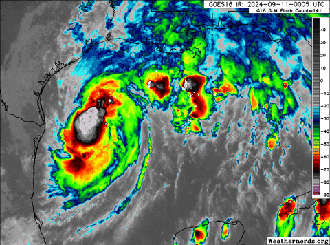
Looking at the IR and Radar images she looks better than earlier this evening.


1 likes

Re: ATL: FRANCINE - Hurricane - Discussion
90kt FL winds… this thing is on its way to cat 2.
1 likes
Igor 2010, Sandy 2012, Fay 2014, Gonzalo 2014, Joaquin 2015, Nicole 2016, Humberto 2019, Imelda 2025
I am only a tropical weather enthusiast. My predictions are not official and may or may not be backed by sound meteorological data. For official information, please refer to the NHC and NWS products.
I am only a tropical weather enthusiast. My predictions are not official and may or may not be backed by sound meteorological data. For official information, please refer to the NHC and NWS products.
Re: ATL: FRANCINE - Hurricane - Discussion
VDM reports a 40 nm eye, and, in their own words:
I do wonder if the relatively large eye may make intensification slightly slower and/or make the eventual weakening phase a bit more susceptible to dry air. On the other hand, it was probably already factored in by the models (I didn't check). Plenty of time for the eye to contract further once it's closed.
EYEWALL HAS 75 PERCENT COVERAGE AROUND THE EYE AND IS SIGNIFICANTLY MORE ORGANIZED THAN ON PREVIOUS PASS
I do wonder if the relatively large eye may make intensification slightly slower and/or make the eventual weakening phase a bit more susceptible to dry air. On the other hand, it was probably already factored in by the models (I didn't check). Plenty of time for the eye to contract further once it's closed.
5 likes
TC naming lists: retirements and intensity
Most aggressive Advisory #1's in North Atlantic (cr. kevin for starting the list)
Most aggressive Advisory #1's in North Atlantic (cr. kevin for starting the list)
-
Stormgodess

- Category 1

- Posts: 316
- Joined: Mon Sep 14, 2020 1:31 am
Re: ATL: FRANCINE - Hurricane - Discussion
Hypercane_Kyle wrote:Definitely going to be an interesting night with this one... might make it past the border of Cat 2 overnight based on that recon pass.
https://i.imgur.com/79lrCrJ.jpeg
Newb question incoming:
Could the giant blob of convection that has been NE of Francine all day, been sucking energy from her in some way?
And now that the blob is dissipating, Francine strengthening?
0 likes
-
weeniepatrol

- Category 5
- Posts: 1345
- Joined: Sat Aug 22, 2020 5:30 pm
- Location: WA State
Re: ATL: FRANCINE - Hurricane - Discussion
...AIR FORCE HURRICANE HUNTERS FIND FRANCINE HAS STRENGTHENED...
Air Force Reserve Hurricane Hunter aircraft data indicate that Francine has strengthened, with maximum sustained winds near 85 mph (140 km/h) with higher gusts.
Air Force Reserve Hurricane Hunter aircraft data indicate that Francine has strengthened, with maximum sustained winds near 85 mph (140 km/h) with higher gusts.
5 likes
-
CrazyC83
- Professional-Met
- Posts: 34316
- Joined: Tue Mar 07, 2006 11:57 pm
- Location: Deep South, for the first time!
Re: ATL: FRANCINE - Hurricane - Discussion
If it can fully close off the eyewall, the intensification rate could certainly increase. Category 2 seems reasonable.
0 likes
-
TomballEd
- Category 5
- Posts: 1318
- Age: 62
- Joined: Wed Aug 16, 2023 4:52 pm
- Location: Spring/Klein area, not Tomball
Re: ATL: FRANCINE - Hurricane - Discussion
It'll be moving into water with less OHC which happens because the ocean depth is lower but it should be moving over 29-30C until it gets very close to land, I am not sure it will have enough time to upwell too much cold water. It started intensifying a bit too late to be a real monster, although one of the 3 km hurricane models gets Francine to Cat 3 before it weakens to a Cat 1 on approach to Louisiana.
'Old' rule of the internet, always prepare for a category higher than the NHC forecast, to be on the safe side. Recon and satellite suggests the NHC forecast plus a Cat for safety is probably the safest way to go.
'Old' rule of the internet, always prepare for a category higher than the NHC forecast, to be on the safe side. Recon and satellite suggests the NHC forecast plus a Cat for safety is probably the safest way to go.
3 likes

Re: ATL: FRANCINE - Hurricane - Discussion
It’s looking like a rocky evening here in New Orleans tomorrow. 4-11pm may be rocky here with TS conditions. We got a break in the rain for now with only sporadic drops but you can see the low clouds starting to move fast out the east.
2 likes
-
otowntiger
- Category 5
- Posts: 1932
- Joined: Tue Aug 31, 2004 7:06 pm
Re: ATL: FRANCINE - Hurricane - Discussion
yep- I guess I should just quit posting lol! Maybe if I start being impressed by the storm and maybe it’ll weaken.Teban54 wrote:otowntiger wrote:CrazyC83 wrote:The Mexican Plateau's dry air may have made a big difference all along - without it, who knows what we would be dealing with now. I know quite a few storms have weakened in that area upon approach too due to dry air.
Yes- it appears that this storm is struggling and just barely made it to hurricane status. Sure, I didn’t think it would make it. Hopefully this is as strong as it gets before it begins succumbing to the forecasted upcoming shear before landfall.
And a whole 20 minutes later, the "struggling" Francine managed to strengthen past the "barely hurricane" status by at least 5 kts, if not more.
2 likes
-
weeniepatrol
- Category 5
- Posts: 1345
- Joined: Sat Aug 22, 2020 5:30 pm
- Location: WA State
Re: ATL: FRANCINE - Hurricane - Discussion
otowntiger wrote:yep- I guess I should just quit posting lol! Maybe if I start being impressed by the storm and maybe it’ll weaken.Teban54 wrote:otowntiger wrote:Yes- it appears that this storm is struggling and just barely made it to hurricane status. Sure, I didn’t think it would make it. Hopefully this is as strong as it gets before it begins succumbing to the forecasted upcoming shear before landfall.
And a whole 20 minutes later, the "struggling" Francine managed to strengthen past the "barely hurricane" status by at least 5 kts, if not more.
Lol it's honestly impressive how many times I make a post and then the complete opposite of what I said immediately occurs. Only in the Tropics baby
4 likes


Re: ATL: FRANCINE - Hurricane - Discussion
Teban54 wrote:VDM reports a 40 nm eye, and, in their own words:EYEWALL HAS 75 PERCENT COVERAGE AROUND THE EYE AND IS SIGNIFICANTLY MORE ORGANIZED THAN ON PREVIOUS PASS
I do wonder if the relatively large eye may make intensification slightly slower and/or make the eventual weakening phase a bit more susceptible to dry air. On the other hand, it was probably already factored in by the models (I didn't check). Plenty of time for the eye to contract further once it's closed.
IIRC this was forecast relatively well by the hurricane models over the past day or so, showing a compact core structure developing then being disrupted and giving way to a much broader core. Those models continued to show that eye maintaining its integrity up until about 3-6 hours before landfall when dry air is finally able to interrupt the core structure.
1 likes
-
WeatherBoy2000
- Category 1
- Posts: 463
- Joined: Mon Apr 10, 2023 9:29 am
Re: ATL: FRANCINE - Hurricane - Discussion
TomballEd wrote:It'll be moving into water with less OHC which happens because the ocean depth is lower but it should be moving over 29-30C until it gets very close to land, I am not sure it will have enough time to upwell too much cold water. It started intensifying a bit too late to be a real monster, although one of the 3 km hurricane models gets Francine to Cat 3 before it weakens to a Cat 1 on approach to Louisiana.
'Old' rule of the internet, always prepare for a category higher than the NHC forecast, to be on the safe side. Recon and satellite suggests the NHC forecast plus a Cat for safety is probably the safest way to go.
https://i.giphy.com/media/v1.Y2lkPTc5MGI3NjExYzhpdDlrbXAxdmltdTV2dDlta2Zic2E1Y3l3ZmI0dHBveGY5NHI5YSZlcD12MV9pbnRlcm5hbF9naWZfYnlfaWQmY3Q9Zw/1221vXxof0dIT24A6x/giphy.gif
Zeta was able to RI into a Cat 3 prior to its landfall in late October if that says anything. Not saying another Zeta will occur, but like that storm Francine is probably moving too quickly to feel any effects of upwelling.
1 likes
Re: ATL: FRANCINE - Hurricane - Discussion
WeatherBoy2000 wrote:TomballEd wrote:It'll be moving into water with less OHC which happens because the ocean depth is lower but it should be moving over 29-30C until it gets very close to land, I am not sure it will have enough time to upwell too much cold water. It started intensifying a bit too late to be a real monster, although one of the 3 km hurricane models gets Francine to Cat 3 before it weakens to a Cat 1 on approach to Louisiana.
'Old' rule of the internet, always prepare for a category higher than the NHC forecast, to be on the safe side. Recon and satellite suggests the NHC forecast plus a Cat for safety is probably the safest way to go.
https://i.giphy.com/media/v1.Y2lkPTc5MGI3NjExYzhpdDlrbXAxdmltdTV2dDlta2Zic2E1Y3l3ZmI0dHBveGY5NHI5YSZlcD12MV9pbnRlcm5hbF9naWZfYnlfaWQmY3Q9Zw/1221vXxof0dIT24A6x/giphy.gif
Zeta was able to RI into a Cat 3 prior to its landfall in late October if that says anything. Not saying another Zeta will occur, but like that storm Francine is probably moving too quickly to feel any effects of upwelling.
Based on the high SSTs Francine is currently traversing in conjunction with the forecast increase in shear prior to landfall I wouldn't be surprised if a Zeta-like situation plays out, with a significant hurricane with a strong northern eyewall but not much wind or rain at all on the southern back half of the storm due to dry air entrainment. I do think that Francine will be moving at enough of a forward pace that upwelling won't be as much of a concern and topical SSTs will be more of an influencing factor than OHC.
1 likes
Who is online
Users browsing this forum: No registered users and 87 guests