Low pressure developing over the western Caribbean Sea (Is Invest 97L)
Moderator: S2k Moderators
Forum rules

The posts in this forum are NOT official forecasts and should not be used as such. They are just the opinion of the poster and may or may not be backed by sound meteorological data. They are NOT endorsed by any professional institution or STORM2K. For official information, please refer to products from the National Hurricane Center and National Weather Service.

Re: Area of low pressure to develop over the western Caribbean sea (0/70)
Landfall at 949 mb in five days
0 likes
-
stormhunter7

- Category 2

- Posts: 763
- Joined: Mon May 26, 2008 3:13 pm
- Location: Panama City Beach, Florida
- Contact:
Re: Area of low pressure to develop over the western Caribbean sea (0/70)
00z GFS is off to the NE in the GOM.... ?
0 likes
The following post is NOT an official forecast and should not be used as such. It is just the opinion of the poster and may or may not be backed by sound meteorological data. It is NOT endorsed by any professional institution including storm2k.org For Official Information please refer to the NHC and NWS products. http://www.nhc.noaa.gov
-
Keldeo1997
- Category 2
- Posts: 688
- Joined: Fri Oct 11, 2019 11:35 pm
Re: Area of low pressure to develop over the western Caribbean sea (0/70)

Yikes on the GFS. Peaks at a 919MB CAT 5
Last edited by Keldeo1997 on Sat Sep 21, 2024 11:16 pm, edited 1 time in total.
3 likes
-
Blown Away

- S2K Supporter

- Posts: 10253
- Joined: Wed May 26, 2004 6:17 am
Re: Area of low pressure to develop over the western Caribbean sea (0/70)

00z GFS… Legit Cat 4 heading towards FL W Coast in 5 days…
0 likes
Hurricane Eye Experience: David 79, Irene 99, Frances 04, Jeanne 04, Wilma 05… Hurricane Brush Experience: Andrew 92, Erin 95, Floyd 99, Matthew 16, Irma 17, Ian 22, Nicole 22…
Re: Area of low pressure to develop over the western Caribbean sea (0/70)
Tampa needs to be watching that sharp turn. Models tend to underestimate it. They usually are sharper and go further south than the models like to show. Happened here in LA with Francine. Not usual that you see a storm that strong modeled north of Tampa. Any similar storms that you guys recall that were modeled like this?
0 likes

Re: Area of low pressure to develop over the western Caribbean sea (0/70)
I'm eyeballing here but looks like just south of Cedar Key on this run
0 likes
-
DunedinDave
- Category 1

- Posts: 269
- Joined: Fri Aug 25, 2023 10:31 am
Re: Area of low pressure to develop over the western Caribbean sea (0/70)
Pelicane wrote:Tampa needs to be watching that sharp turn. Models tend to underestimate it. They usually are sharper and go further south than the models like to show. Happened here in LA with Francine. Not usual that you see a storm that strong modeled north of Tampa. Any similar storms that you guys recall that were modeled like this?
Ian was up until 2 days betore landfall. Then the track shifted south.
1 likes
-
Blown Away
- S2K Supporter
- Posts: 10253
- Joined: Wed May 26, 2004 6:17 am
Re: Area of low pressure to develop over the western Caribbean sea (0/70)
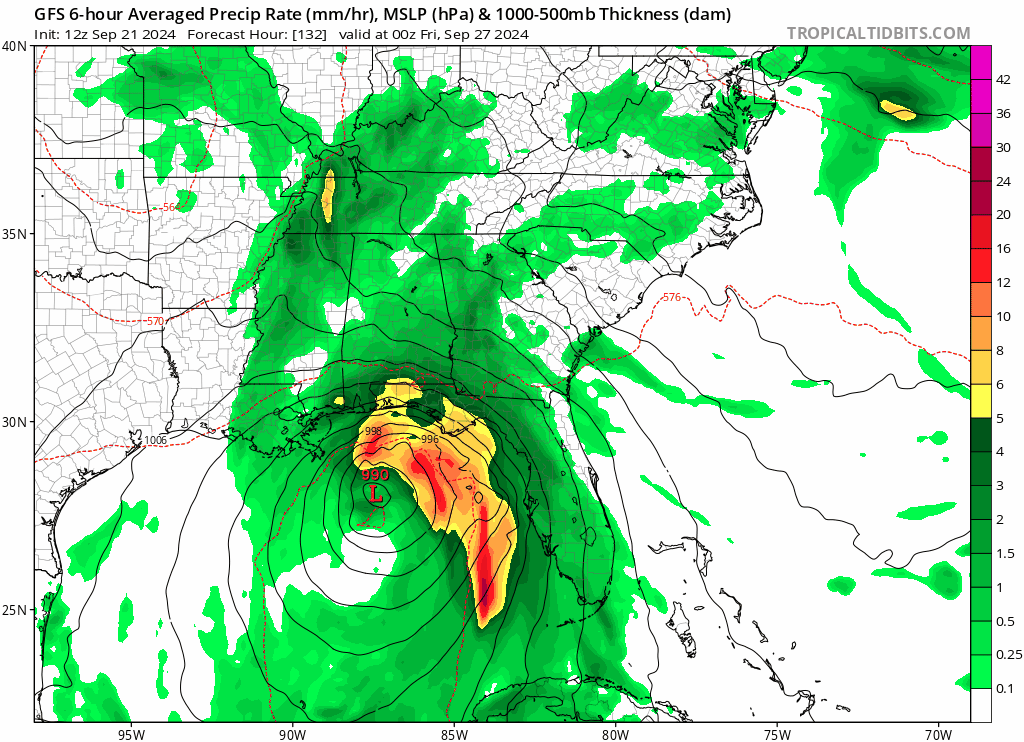
Geez this is a scary trend towards FL…
Last edited by Blown Away on Sat Sep 21, 2024 11:23 pm, edited 1 time in total.
0 likes
Hurricane Eye Experience: David 79, Irene 99, Frances 04, Jeanne 04, Wilma 05… Hurricane Brush Experience: Andrew 92, Erin 95, Floyd 99, Matthew 16, Irma 17, Ian 22, Nicole 22…
Re: Area of low pressure to develop over the western Caribbean sea (0/70)
DunedinDave wrote:Pelicane wrote:Tampa needs to be watching that sharp turn. Models tend to underestimate it. They usually are sharper and go further south than the models like to show. Happened here in LA with Francine. Not usual that you see a storm that strong modeled north of Tampa. Any similar storms that you guys recall that were modeled like this?
Ian was up until 2 days betore landfall. Then the track shifted south.
I remember the GFS was insistant Ian would go into the panhandle, but most models were further south. This looks like it's entering the Gulf further west so any sharp turn would go further up the peninsula I'd think.
2 likes

Re: Area of low pressure to develop over the western Caribbean sea (0/70)
GFS has sped up the trough timing the past 3 runs, leading to the east shifts. Euro and Canadian have the trough sitting over Texas/Louisiana leading to more westward tracks. Seems like it's GFS vs everybody at this stage. Someone's going to get the upper patterns wrong, just a matter of who
2 likes
-
SconnieCane
- Category 5

- Posts: 1013
- Joined: Thu Aug 02, 2018 5:29 pm
- Location: Madison, WI
Re: Area of low pressure to develop over the western Caribbean sea (0/70)
Keldeo1997 wrote:https://cdn.discordapp.com/attachments/1157676956674949152/1287265322365223065/Screenshot_204.png?ex=66f0eac1&is=66ef9941&hm=3432904b5a98538439db9a4c1051d3dbb70de647f92b9287a66cfce345fe4e21&
Yikes on the GFS. Peaks at a 919MB CAT 5
Hmmm...I'm also using TT but it shows 950 mb at that timeframe on the 00Z run for me. Then 949 MB on the next frame, close to landfall.
Edit...I was using the "Western Atlantic" sector...when I use the "Southeast US" sector it does appear to show that 919 MB at FH114...bizarre.
Last edited by SconnieCane on Sat Sep 21, 2024 11:28 pm, edited 1 time in total.
0 likes
-
Blown Away
- S2K Supporter
- Posts: 10253
- Joined: Wed May 26, 2004 6:17 am
Re: Area of low pressure to develop over the western Caribbean sea (0/70)
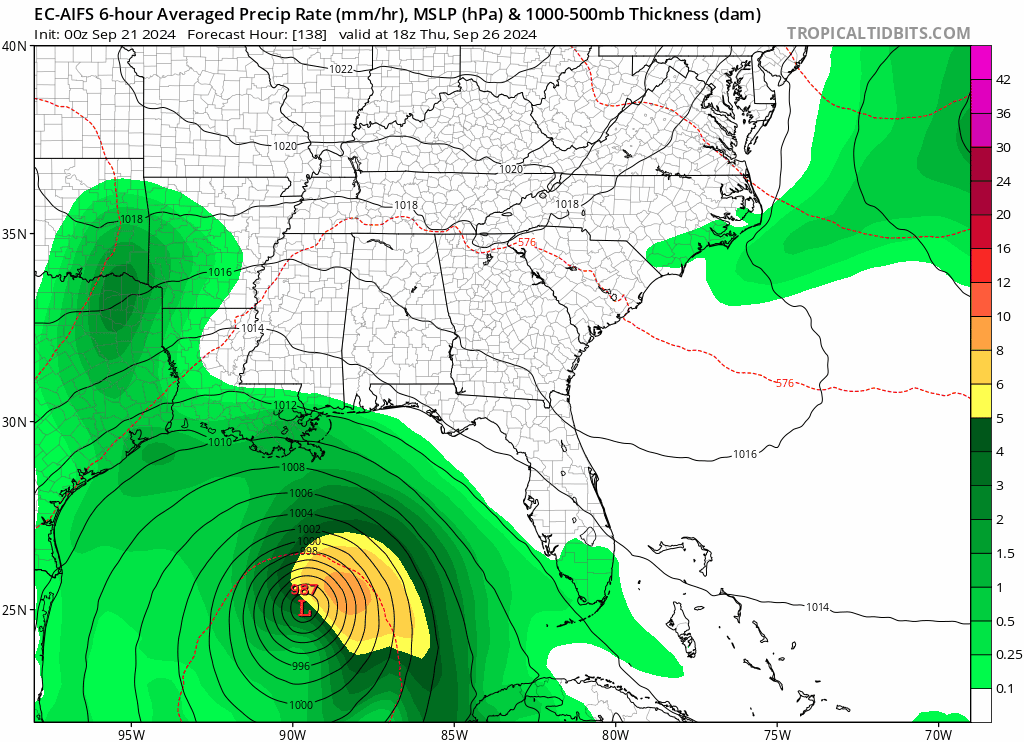
EC-AIFS trend today…
Last edited by Blown Away on Sat Sep 21, 2024 11:26 pm, edited 1 time in total.
0 likes
Hurricane Eye Experience: David 79, Irene 99, Frances 04, Jeanne 04, Wilma 05… Hurricane Brush Experience: Andrew 92, Erin 95, Floyd 99, Matthew 16, Irma 17, Ian 22, Nicole 22…
-
Category5Kaiju

- Category 5
- Posts: 4345
- Joined: Thu Dec 24, 2020 12:45 pm
- Location: Seattle during the summer, Phoenix during the winter
Re: Area of low pressure to develop over the western Caribbean sea (0/70)
Pelicane wrote:DunedinDave wrote:Pelicane wrote:Tampa needs to be watching that sharp turn. Models tend to underestimate it. They usually are sharper and go further south than the models like to show. Happened here in LA with Francine. Not usual that you see a storm that strong modeled north of Tampa. Any similar storms that you guys recall that were modeled like this?
Ian was up until 2 days betore landfall. Then the track shifted south.
I remember the GFS was insistant Ian would go into the panhandle, but most models were further south. This looks like it's entering the Gulf further west so any sharp turn would go further up the peninsula I'd think.
One thing about Ian and Charley is that they share an interesting similarity aside from how they were forecast to slam Tampa directly at some point in their early stages but ultimately missed to the south: they both hit the western tip of Cuba.
3 likes
Unless explicitly stated, all information in my posts is based on my own opinions and observations. Tropical storms and hurricanes can be extremely dangerous. Refer to an accredited weather research agency or meteorologist if you need to make serious decisions regarding an approaching storm.
-
Blown Away
- S2K Supporter
- Posts: 10253
- Joined: Wed May 26, 2004 6:17 am
Re: Area of low pressure to develop over the western Caribbean sea (0/70)
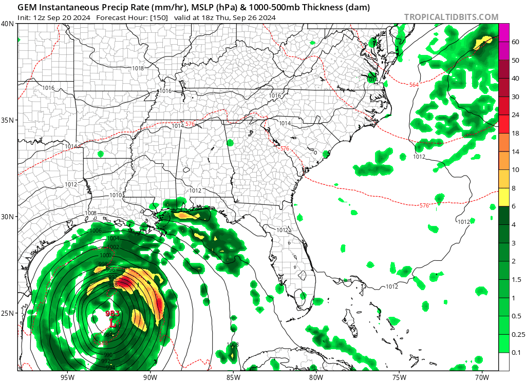
CMC Trend Today…
0 likes
Hurricane Eye Experience: David 79, Irene 99, Frances 04, Jeanne 04, Wilma 05… Hurricane Brush Experience: Andrew 92, Erin 95, Floyd 99, Matthew 16, Irma 17, Ian 22, Nicole 22…

Re: Area of low pressure to develop over the western Caribbean sea (0/70)
Keldeo1997 wrote:https://cdn.discordapp.com/attachments/1157676956674949152/1287265322365223065/Screenshot_204.png?ex=66f0eac1&is=66ef9941&hm=3432904b5a98538439db9a4c1051d3dbb70de647f92b9287a66cfce345fe4e21&
Yikes on the GFS. Peaks at a 919MB CAT 5
Tropical Tidbits has the tendency to put random contour lines and other stuff over pressure numbers. That's actually 949 at that frame, not 919.
2 likes
TC naming lists: retirements and intensity
Most aggressive Advisory #1's in North Atlantic (cr. kevin for starting the list)
Most aggressive Advisory #1's in North Atlantic (cr. kevin for starting the list)
-
Blown Away
- S2K Supporter
- Posts: 10253
- Joined: Wed May 26, 2004 6:17 am
Re: Area of low pressure to develop over the western Caribbean sea (0/70)
IMO, if NHC buying into these 00z models speeding up towards FL, we are near the 5 day window and at minimum PTC advisories should start very soon…
0 likes
Hurricane Eye Experience: David 79, Irene 99, Frances 04, Jeanne 04, Wilma 05… Hurricane Brush Experience: Andrew 92, Erin 95, Floyd 99, Matthew 16, Irma 17, Ian 22, Nicole 22…
Re: Area of low pressure to develop over the western Caribbean sea (0/70)
Keldeo1997 wrote:https://cdn.discordapp.com/attachments/1157676956674949152/1287265322365223065/Screenshot_204.png?ex=66f0eac1&is=66ef9941&hm=3432904b5a98538439db9a4c1051d3dbb70de647f92b9287a66cfce345fe4e21&
Yikes on the GFS. Peaks at a 919MB CAT 5
It’s a 4, not a 1, you can see that if you switch to the mlsp view, sometimes the numbers get a little screwed up. I’m not sure what causes that.
1 likes
Re: Area of low pressure to develop over the western Caribbean sea (0/70)
Blown Away wrote:IMO, if NHC buying into these 00z models speeding up towards FL, we are near the 5 day window and at minimum PTC advisories should start very soon…
I'd hate to be in their position. Posting on a message board knowing nobody cares about my opinions makes it a heck of a lot less stressful
3 likes

Re: Area of low pressure to develop over the western Caribbean sea (0/70)
Canadian and European seem to be the in the most agreement, with the GFS being an outlier. IF the latest Canadian plays out we'll probably get another unnamed PTC out of this and not much more.
0 likes
The above post is not official and should not be used as such. It is the opinion of the poster and may or may not be backed by sound meteorological data. It is not endorsed by any professional institution or storm2k.org. For official information, please refer to the NHC and NWS products.
-
ConvergenceZone
.gif)
- Category 5
- Posts: 5241
- Joined: Fri Jul 29, 2005 1:40 am
- Location: Northern California
Re: Area of low pressure to develop over the western Caribbean sea (0/70)
So both ICON and GFS have big intensity increases? Interesting. A trend?
0 likes
Who is online
Users browsing this forum: pepecool20 and 212 guests