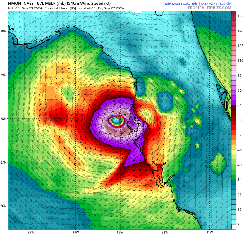
ElectricStorm wrote:HMON joins in with 909mb near landfall... winds "only" mid-range Cat 4
@143 mph winds to St Pete/Tampa… Yikes
Moderator: S2k Moderators


ElectricStorm wrote:HMON joins in with 909mb near landfall... winds "only" mid-range Cat 4

ElectricStorm wrote:HMON joins in with 909mb near landfall... winds "only" mid-range Cat 4
Blown Away wrote:Climatology it’s so rare for a Cat 4/5 between Appalachicola to Tampa… Ultimately IMO 97L goes W or S of this region…
CrazyC83 wrote:Blown Away wrote:Climatology it’s so rare for a Cat 4/5 between Appalachicola to Tampa… Ultimately IMO 97L goes W or S of this region…
I wouldn't use that as a reasoning - we thought such wasn't in the cards ever in the Panhandle, and then Michael broke the rules in 2018. There's no reason why a category 4 or 5 can't hit that region.
Blown Away wrote:CrazyC83 wrote:Blown Away wrote:Climatology it’s so rare for a Cat 4/5 between Appalachicola to Tampa… Ultimately IMO 97L goes W or S of this region…
I wouldn't use that as a reasoning - we thought such wasn't in the cards ever in the Panhandle, and then Michael broke the rules in 2018. There's no reason why a category 4 or 5 can't hit that region.

CrazyC83 wrote:ElectricStorm wrote:HMON joins in with 909mb near landfall... winds "only" mid-range Cat 4
A strengthening 909 mb storm would likely be about 150 kt winds.

BobHarlem wrote:0z GFS then moves it near Atlanta still with a cat 3 pressure (967mb) and still hurricane strength over East Tennessee. Inland folks are not going to be prepared for this.

GalvestonDuck wrote:BobHarlem wrote:0z GFS then moves it near Atlanta still with a cat 3 pressure (967mb) and still hurricane strength over East Tennessee. Inland folks are not going to be prepared for this.
Has the Atlanta area ever been hit but something stronger than an inland depression or tropical storm?

 .
.
GalvestonDuck wrote:BobHarlem wrote:0z GFS then moves it near Atlanta still with a cat 3 pressure (967mb) and still hurricane strength over East Tennessee. Inland folks are not going to be prepared for this.
Has the Atlanta area ever been hit but something stronger than an inland depression or tropical storm?


chris_fit wrote:Here are the last 4 GFS Runs. Eastern shifts continue. Getting a little uneasy here in Tampa area... This is wayyy to close for comfort.
https://i.imgur.com/cLh9LnO.gif
Users browsing this forum: No registered users and 89 guests


