Possible development in the Gulf of Mexico (Is Invest 92L)

This is the general tropical discussion area. Anyone can take their shot at predicting a storms path.

Moderator: S2k Moderators

Forum rules

The posts in this forum are NOT official forecasts and should not be used as such. They are just the opinion of the poster and may or may not be backed by sound meteorological data. They are NOT endorsed by any professional institution or STORM2K. For official information, please refer to products from the National Hurricane Center and National Weather Service.

Help Support Storm2K
Message
Author
User avatar
eastcoastFL
Category 5
Category 5
Posts: 3901
Age: 43
Joined: Thu Apr 12, 2007 12:29 pm
Location: Palm City, FL

Re: Possible development in the Western Caribbean (0/50)

#161 Postby eastcoastFL » Sat Sep 28, 2024 5:19 pm

CrazyC83 wrote:Interestingly, this could be stronger off the east coast, then the question is - does the trough axis go neutral and drive it inland further up the coast?
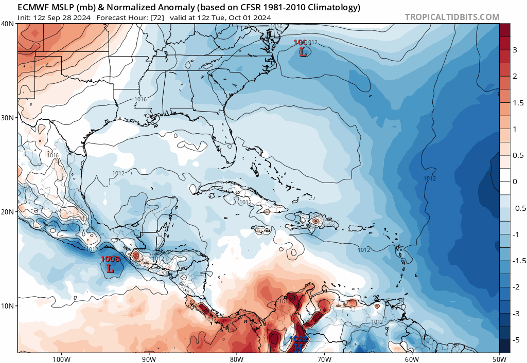

And that’s where it could really add to the flooding issues in the SE.
0 likes   
Personal Forecast Disclaimer:
The posts in this forum are NOT official forecast and should not be used as such. They are just the opinion of the poster and may or may not be backed by sound meteorological data. They are NOT endorsed by any professional institution or storm2k.org. For official information, please refer to the NHC and NWS products.

User avatar
eastcoastFL
Category 5
Category 5
Posts: 3901
Age: 43
Joined: Thu Apr 12, 2007 12:29 pm
Location: Palm City, FL

Re: Possible development in the Western Caribbean (0/50)

#162 Postby eastcoastFL » Sat Sep 28, 2024 5:22 pm

gatorcane wrote:
Blown Away wrote:


What do you think Gatorcane, can we get more than a TS on that type of track??


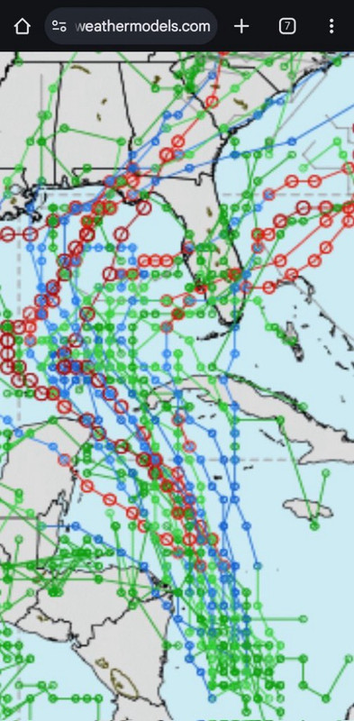
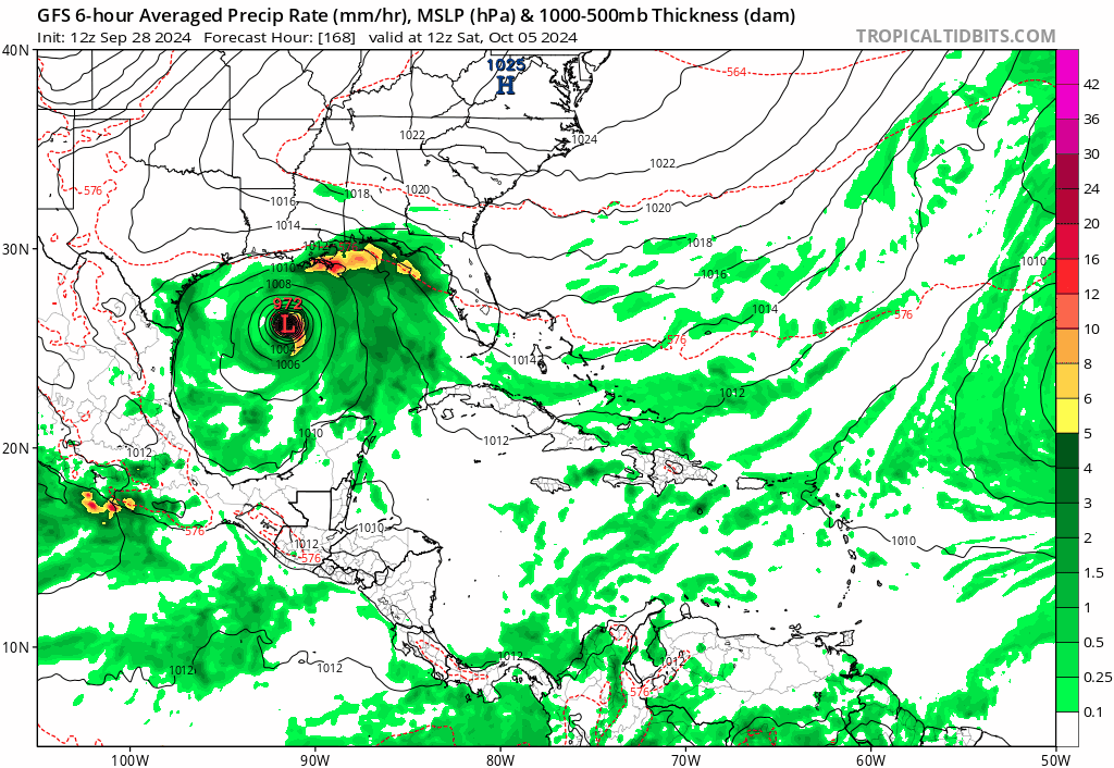
I think it's possible. The GFS shows a CAT 2/3 hurricane and has the system even further west than the Euro before the ENE turn, and it is likely too far west anyway. If we go back and look at historical tracks, would we find one that hits the peninsula as a hurricane on an ENE track from the Central Gulf?

https://i.postimg.cc/Pr4GV6wH/gfs-mslp-pcpn-watl-fh168-204.gif


This might be the one and only time that I will ever say I hope this ends up our way in S. Florida. North Florida, GA and the Carolinas can’t handle anymore of this.
5 likes   
Personal Forecast Disclaimer:
The posts in this forum are NOT official forecast and should not be used as such. They are just the opinion of the poster and may or may not be backed by sound meteorological data. They are NOT endorsed by any professional institution or storm2k.org. For official information, please refer to the NHC and NWS products.

User avatar
gatorcane
S2K Supporter
S2K Supporter
Posts: 23691
Age: 47
Joined: Sun Mar 13, 2005 3:54 pm
Location: Boca Raton, FL

Re: Possible development in the Western Caribbean (0/50)

#163 Postby gatorcane » Sat Sep 28, 2024 5:34 pm

The entire 18Z GFS track shifted to the right quite a bit this run, and while it landfalls in the panhandle (at almost 200 hours which is still far out, plenty of shifting to still happen), that hook to the right is definitely something to keep an eye on because this could end up easily being a storm that hits the west coast of Florida from the Central Gulf on an ENE track.

Image
Last edited by gatorcane on Sat Sep 28, 2024 5:46 pm, edited 6 times in total.
1 likes   

User avatar
SFLcane
S2K Supporter
S2K Supporter
Posts: 10163
Age: 47
Joined: Sat Jun 05, 2010 1:44 pm
Location: Lake Worth Florida

Re: Possible development in the Western Caribbean (0/50)

#164 Postby SFLcane » Sat Sep 28, 2024 5:34 pm

Seems like there is a protective ridge over FL on the gfs that atleast keeps it east of extreme SFL. Hoping it stays far away from The panhandle.
Last edited by SFLcane on Sat Sep 28, 2024 5:51 pm, edited 3 times in total.
1 likes   

Mouton
S2K Supporter
S2K Supporter
Posts: 221
Age: 79
Joined: Sat Jul 30, 2011 8:13 am
Location: Amelia Island Florida

Re: Possible development in the Western Caribbean (0/50)

#165 Postby Mouton » Sat Sep 28, 2024 5:38 pm

Unfortunately latest 18Z GFS has it a bit west of Helene landfall as a 980 mb storm, cat 1-2. It was quite accurate for helene as I recall. Not looking for any rerun, just cleared out the debris this AM, yes as far east as Amelia Island. Still 8 days out so things can change. :roll:
1 likes   

User avatar
cycloneye
Admin
Admin
Posts: 145295
Age: 68
Joined: Thu Oct 10, 2002 10:54 am
Location: San Juan, Puerto Rico

Re: Possible development in the Western Caribbean (0/50)

#166 Postby cycloneye » Sat Sep 28, 2024 6:23 pm

8 PM:

Western Caribbean Sea and Gulf of Mexico:
An area of low pressure is expected to form over the western
Caribbean Sea in a couple of days. Environmental conditions are
forecast to be conducive for gradual development thereafter, and a
tropical depression could form around the middle part of next week.
This system is expected to move northwestward into the Gulf of
Mexico during the latter portion of next week, and interests in the
northwestern Caribbean Sea and along the U.S. Gulf Coast should
monitor its progress.
* Formation chance through 48 hours...low...near 0 percent.
* Formation chance through 7 days...medium...50 percent.
0 likes   
Visit the Caribbean-Central America Weather Thread where you can find at first post web cams,radars
and observations from Caribbean basin members Click Here

User avatar
cycloneye
Admin
Admin
Posts: 145295
Age: 68
Joined: Thu Oct 10, 2002 10:54 am
Location: San Juan, Puerto Rico

Re: Possible development in the Western Caribbean (0/50)

#167 Postby cycloneye » Sat Sep 28, 2024 7:30 pm

Oh boy. Helene did little too cool the waters in the EGOM as it moved fast thru that area.

Image
3 likes   
Visit the Caribbean-Central America Weather Thread where you can find at first post web cams,radars
and observations from Caribbean basin members Click Here

psyclone
S2K Supporter
S2K Supporter
Posts: 4762
Joined: Wed Aug 24, 2005 9:04 pm
Location: palm harbor fl

Re: Possible development in the Western Caribbean (0/50)

#168 Postby psyclone » Sat Sep 28, 2024 8:01 pm

They dropped some but they're still warm enough to power a strong storm. We've had a deep southwest flow off the gulf in the wake of Helene and it remains stubbornly hot and humid owing to all that gulf warmth..
2 likes   

Horn1991
Tropical Low
Tropical Low
Posts: 40
Joined: Mon Jul 20, 2020 8:54 am
Location: The Woodlands, Texas

Re: Possible development in the Western Caribbean (0/50)

#169 Postby Horn1991 » Sat Sep 28, 2024 8:42 pm

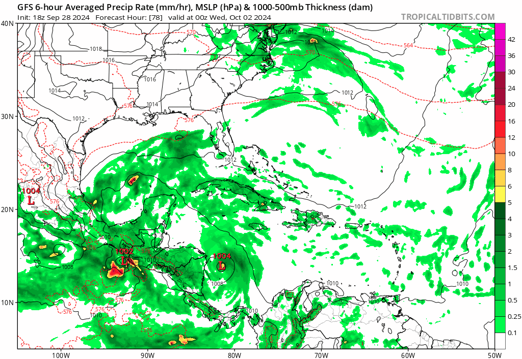
gatorcane wrote:The entire 18Z GFS track shifted to the right quite a bit this run, and while it landfalls in the panhandle (at almost 200 hours which is still far out, plenty of shifting to still happen), that hook to the right is definitely something to keep an eye on because this could end up easily being a storm that hits the west coast of Florida from the Central Gulf on an ENE track.

https://i.postimg.cc/G27ftMsv/gfs-mslp-pcpn-watl-fh78-216.gif


What's that sweet rainmaker for Houston just before the real deal?
0 likes   

Stormlover70
Tropical Storm
Tropical Storm
Posts: 175
Age: 55
Joined: Fri Jun 21, 2024 5:31 am
Location: New port richey

Re: Possible development in the Western Caribbean (0/50)

#170 Postby Stormlover70 » Sat Sep 28, 2024 9:01 pm

Helene was devastating. Even 100 miles offshore of us. Keep it away!!!!!!!
1 likes   

User avatar
SFLcane
S2K Supporter
S2K Supporter
Posts: 10163
Age: 47
Joined: Sat Jun 05, 2010 1:44 pm
Location: Lake Worth Florida

Re: Possible development in the Western Caribbean (0/50)

#171 Postby SFLcane » Sat Sep 28, 2024 9:12 pm

18z GEFS ensembles..

Image
3 likes   

Weathertracker96
Tropical Storm
Tropical Storm
Posts: 104
Joined: Mon Oct 16, 2023 3:41 pm

Re: Possible development in the Western Caribbean (0/50)

#172 Postby Weathertracker96 » Sat Sep 28, 2024 9:15 pm

SFLcane wrote:18z GEFS ensembles..

https://i.postimg.cc/LX9qsm97/IMG-9528.jpg


More east it seems. Timing will be everything regarding the steering.
1 likes   

CrazyC83
Professional-Met
Professional-Met
Posts: 34002
Joined: Tue Mar 07, 2006 11:57 pm
Location: Deep South, for the first time!

Re: Possible development in the Western Caribbean (0/50)

#173 Postby CrazyC83 » Sat Sep 28, 2024 9:37 pm

Even if this moves over the Florida peninsula, we have to watch to make sure the trough doesn't pull it back in for a second landfall on the east coast, especially in the Carolinas. That would make the misery even worse.
3 likes   

User avatar
Teban54
Category 5
Category 5
Posts: 3204
Joined: Sat May 19, 2018 1:19 pm

Re: Possible development in the Western Caribbean (0/50)

#174 Postby Teban54 » Sun Sep 29, 2024 12:02 am

0z GFS peaks at 973 mb followed by a slightly weaker landfall near Panama City, similar to 18z in track and slightly stronger in intensity (but much weaker than the ballistic 12z):

Image
0 likes   

User avatar
canebeard
Tropical Depression
Tropical Depression
Posts: 98
Joined: Sun Jul 05, 2009 4:06 pm
Contact:

Re: Possible development in the Western Caribbean (0/50)

#175 Postby canebeard » Sun Sep 29, 2024 2:08 am

Rear flank downdraft hurricane formation???

Looking at the 00 GFS, the upper high that maintained Helene is now offshore the Southeast coast and forecast to move/expand southward, then expands westward: then supplies favorable outflow for the supposed new formation South of western Cuber, again. Appears similar, on a much larger scale of course, to new thunderstorms forming along the outflow boundaries of the old. 120 hr gfs 200 mb map below


Image
1 likes   
List of 79 tropical cyclones intercepted by Richard Horodner:
http://www.canebeard.com/page/page/572246.htm
former storm2k screenname Beoumont 2009+

User avatar
GCANE
S2K Supporter
S2K Supporter
Posts: 11496
Joined: Mon Oct 22, 2007 8:03 am

Re: Possible development in the Western Caribbean (0/50)

#176 Postby GCANE » Sun Sep 29, 2024 2:45 am

My first instinct, without looking at all the variable and parameters, is that if this starts deep in W Carib and moves thru the Yucatan Channel, this aint going to be no strong TS or weak Cat1. Need to see the details in the next day on how GFS forecasts the environment for it to develop.
3 likes   

HurricaneRyan
Category 3
Category 3
Posts: 813
Age: 31
Joined: Sun Dec 05, 2010 3:05 pm

Re: Possible development in the Western Caribbean (0/50)

#177 Postby HurricaneRyan » Sun Sep 29, 2024 3:31 am

I'm getting Opal/Roxanne and Isidore/Lili vibes from this secondary system just after Helene.
1 likes   
Kay '22 Hilary '23

User avatar
cycloneye
Admin
Admin
Posts: 145295
Age: 68
Joined: Thu Oct 10, 2002 10:54 am
Location: San Juan, Puerto Rico

Re: Possible development in the Western Caribbean (0/50)

#178 Postby cycloneye » Sun Sep 29, 2024 4:16 am

2 AM:

Western Caribbean Sea and Gulf of Mexico:
An area of low pressure is expected to form over the western
Caribbean Sea in a couple of days. Environmental conditions are
forecast to be conducive for gradual development thereafter, and a
tropical depression could form around the middle part of this
week. This system is expected to move northwestward into the Gulf
of Mexico during the latter portion of this week, and interests in
the northwestern Caribbean Sea and along the U.S. Gulf Coast should
monitor its progress.
* Formation chance through 48 hours...low...near 0 percent.
* Formation chance through 7 days...medium...50 percent.
0 likes   
Visit the Caribbean-Central America Weather Thread where you can find at first post web cams,radars
and observations from Caribbean basin members Click Here

jlauderdal
S2K Supporter
S2K Supporter
Posts: 7182
Joined: Wed May 19, 2004 5:46 am
Location: NE Fort Lauderdale
Contact:

Re: Possible development in the Western Caribbean (0/50)

#179 Postby jlauderdal » Sun Sep 29, 2024 4:20 am

GCANE wrote:My first instinct, without looking at all the variable and parameters, is that if this starts deep in W Carib and moves thru the Yucatan Channel, this aint going to be no strong TS or weak Cat1. Need to see the details in the next day on how GFS forecasts the environment for it to develop.

Euro has it stretched out with a weak low riding NE out to sea. Euro hasn't exactly been showing it has a handle on tropical setups recently, so will toss this solution for now. Something more organized seems likely given the favorable conditions.
0 likes   

mantis83
Tropical Storm
Tropical Storm
Posts: 198
Joined: Fri Dec 05, 2003 4:47 pm

Re: Possible development in the Western Caribbean (0/50)

#180 Postby mantis83 » Sun Sep 29, 2024 5:13 am

6Z gfs has this a weak stretched out mess like the euro now......
0 likes   


Return to “Talkin' Tropics”

Who is online

Users browsing this forum: kenayers, LarryWx, Sciencerocks and 33 guests