Possible development in the Gulf of Mexico (Is Invest 92L)

This is the general tropical discussion area. Anyone can take their shot at predicting a storms path.

Moderator: S2k Moderators

Forum rules

The posts in this forum are NOT official forecasts and should not be used as such. They are just the opinion of the poster and may or may not be backed by sound meteorological data. They are NOT endorsed by any professional institution or STORM2K. For official information, please refer to products from the National Hurricane Center and National Weather Service.

Help Support Storm2K
Message
Author
jlauderdal
S2K Supporter
S2K Supporter
Posts: 7182
Joined: Wed May 19, 2004 5:46 am
Location: NE Fort Lauderdale
Contact:

Re: Possible development in the Gulf of Mexico (0/30)

#401 Postby jlauderdal » Thu Oct 03, 2024 1:40 pm

SFLcane wrote:
boca wrote:
SFLcane wrote:
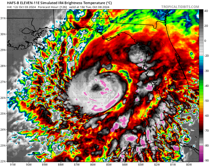
Yes.. appears to be a cat 1


Which way is it moving ?


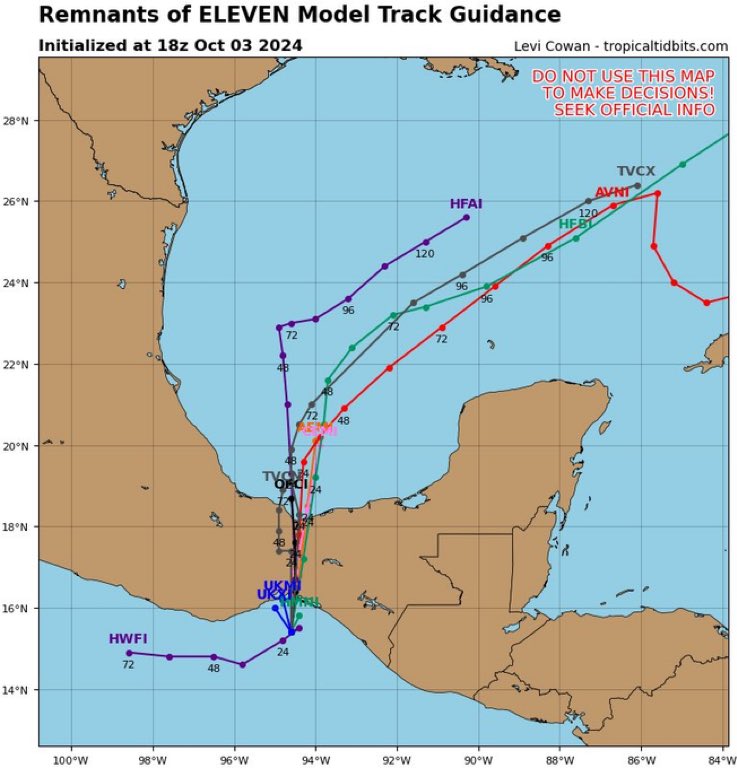
https://i.postimg.cc/8cbq7mkx/BBB.gif

I missed the mountains in the I-4 corridor causing the system to bounce. :D

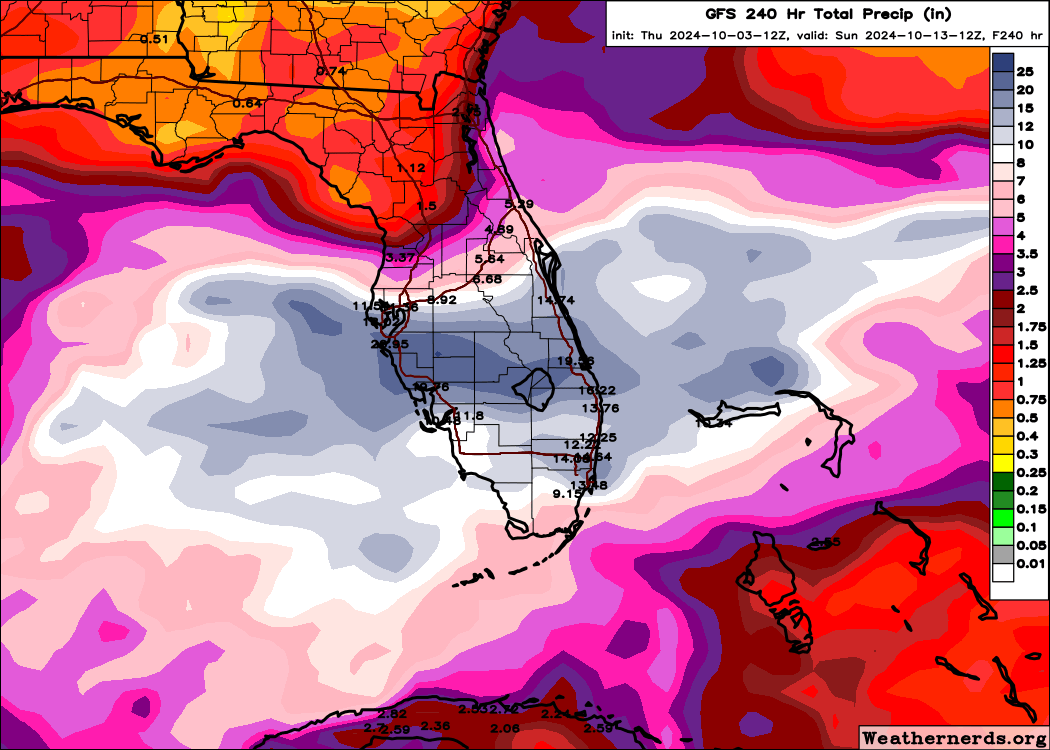
If I was King for a day, I would start sandbag distribution in Florida tomorrow. Big rain isn't unusual, the public will be warned in plenty of time so let's not see Floridians act like they were shocked when this evolves. Just because it hasn't happened before is no reason to be caught off guard, especially after last week's events in the Appalachia. 10 days food and water is a good start, that can be done on a tight budget if needed.
0 likes   

User avatar
toad strangler
S2K Supporter
S2K Supporter
Posts: 4543
Joined: Sun Jul 28, 2013 3:09 pm
Location: Earth
Contact:

Re: Possible development in the Gulf of Mexico (0/30)

#402 Postby toad strangler » Thu Oct 03, 2024 1:47 pm

Generally, if this did become at least a TS the track is pretty darn anomalous from this general area IF there was genesis this far west. Which is unlikely. Still pretty curious though.

Image
Last edited by toad strangler on Thu Oct 03, 2024 2:04 pm, edited 1 time in total.
0 likes   

User avatar
ColdMiser123
Professional-Met
Professional-Met
Posts: 904
Age: 29
Joined: Mon Sep 26, 2016 3:26 pm
Location: Northeast US

Re: Possible development in the Gulf of Mexico (0/30)

#403 Postby ColdMiser123 » Thu Oct 03, 2024 1:51 pm

Both HAFS models for 11E show the main area of development being in the BOC. Probably too aggressive with intensity though.
0 likes   
B.S., M.S., Meteorology & Atmospheric Science

User avatar
SFLcane
S2K Supporter
S2K Supporter
Posts: 10163
Age: 47
Joined: Sat Jun 05, 2010 1:44 pm
Location: Lake Worth Florida

Re: Possible development in the Gulf of Mexico (0/30)

#404 Postby SFLcane » Thu Oct 03, 2024 1:59 pm

ColdMiser123 wrote:Both HAFS models for 11E show the main area of development being in the BOC. Probably too aggressive with intensity though.


Indeed!

Image
2 likes   

User avatar
SFLcane
S2K Supporter
S2K Supporter
Posts: 10163
Age: 47
Joined: Sat Jun 05, 2010 1:44 pm
Location: Lake Worth Florida

Re: Possible development in the Gulf of Mexico (0/30)

#405 Postby SFLcane » Thu Oct 03, 2024 2:44 pm

Image
3 likes   

Pasmorade
Tropical Storm
Tropical Storm
Posts: 141
Joined: Mon Jul 01, 2024 7:44 am
Location: Florida

Re: Possible development in the Gulf of Mexico (0/30)

#406 Postby Pasmorade » Thu Oct 03, 2024 2:52 pm


Could the Gulf be conducive enough for them to regenerate?
0 likes   

Michele B
S2K Supporter
S2K Supporter
Posts: 1114
Joined: Thu Aug 25, 2016 8:08 am
Location: SWFL

Re: Possible development in the Gulf of Mexico (0/30)

#407 Postby Michele B » Thu Oct 03, 2024 3:01 pm

SFLcane wrote:This might be just as bad as a TC just without the wind for the Florida Peninsula. :eek:

https://i.postimg.cc/tTNRpP6m/kkk.png


Where I live, I can handle the rain much better than I can the wind!

I'll take it.
0 likes   
Cleo - 1964, Betsy - 1965, David - 1979, Andrew - 1992, Charlie (Francis, Ivan, Jeanne) - 2004, Irma - 2017, Ian - 2022

typhoonty
Tropical Storm
Tropical Storm
Posts: 121
Age: 30
Joined: Wed May 31, 2017 10:37 pm
Location: Fort Myers / Tallahassee, FL
Contact:

Re: Possible development in the Gulf of Mexico (0/30)

#408 Postby typhoonty » Thu Oct 03, 2024 3:11 pm

Michele B wrote:
SFLcane wrote:This might be just as bad as a TC just without the wind for the Florida Peninsula. :eek:

https://i.postimg.cc/tTNRpP6m/kkk.png


Where I live, I can handle the rain much better than I can the wind!

I'll take it.


I won't. West central and SWFL is 15-20" above normal for the year and those qpf's are above Debby even for Sarasota. Would NOT be fun.
1 likes   
FSU Meteorology student, opinions are mine, 20 years experience covering TC's, consult NHC/Local officials when making decisions.

Gabrielle '01, Michelle '01, Charley '04, Frances '04, Dennis '05, Katrina '05, Rita '05, Wilma '05, Fay '08, Isaac '12 Hermine '16, Irma '17, Michael '18, Eta '20, Elsa '21, IAN '22, Idalia '23, Debby '24, Helene '24

User avatar
SFLcane
S2K Supporter
S2K Supporter
Posts: 10163
Age: 47
Joined: Sat Jun 05, 2010 1:44 pm
Location: Lake Worth Florida

Re: Possible development in the Gulf of Mexico (0/30)

#409 Postby SFLcane » Thu Oct 03, 2024 3:17 pm

on its way into the BOC..

Initially focused on tropical wave moving into the BoC with a part of the monsoon trough lifting north, but the Caribbean vortex dominating. Now we're looking at vorticity from 11-E

Image

Image
0 likes   

jlauderdal
S2K Supporter
S2K Supporter
Posts: 7182
Joined: Wed May 19, 2004 5:46 am
Location: NE Fort Lauderdale
Contact:

Re: Possible development in the Gulf of Mexico (0/30)

#410 Postby jlauderdal » Thu Oct 03, 2024 3:28 pm

SFLcane wrote:on its way into the BOC..

Initially focused on tropical wave moving into the BoC with a part of the monsoon trough lifting north, but the Caribbean vortex dominating. Now we're looking at vorticity from 11-E

https://i.postimg.cc/1zdHKC3D/bbbb.gif

https://i.postimg.cc/T2g9rcMW/vvv.png

SFLCane isn't going to be happy until a model map can be posted that has something crushing NE Fort Lauderdale. :D :D

I'm supposed to go to NYC next weds, that's looking iffy. A good captain stays with his ship :D :D :D
1 likes   

User avatar
SFLcane
S2K Supporter
S2K Supporter
Posts: 10163
Age: 47
Joined: Sat Jun 05, 2010 1:44 pm
Location: Lake Worth Florida

Re: Possible development in the Gulf of Mexico (0/30)

#411 Postby SFLcane » Thu Oct 03, 2024 3:32 pm

jlauderdal wrote:
SFLcane wrote:on its way into the BOC..

Initially focused on tropical wave moving into the BoC with a part of the monsoon trough lifting north, but the Caribbean vortex dominating. Now we're looking at vorticity from 11-E

https://i.postimg.cc/1zdHKC3D/bbbb.gif

https://i.postimg.cc/T2g9rcMW/vvv.png

SFLCane isn't going to be happy until a model map can be posted that has something crushing NE Fort Lauderdale. :D :D

I'm supposed to go to NYC next weds, that's looking iffy. A good captain stays with his ship :D :D :D


:lol:

Its a complicated setup surely we shall see what happens but either way lots of rain incoming.
0 likes   

User avatar
Emmett_Brown
Category 5
Category 5
Posts: 1432
Joined: Wed Aug 24, 2005 9:10 pm
Location: Sarasota FL

Re: Possible development in the Gulf of Mexico (0/30)

#412 Postby Emmett_Brown » Thu Oct 03, 2024 4:04 pm

Next name on the list is Milton. That name seems fitting given the age demographic of West Central Florida… so there could be some destiny playing out.
6 likes   

User avatar
MetroMike
Category 4
Category 4
Posts: 952
Joined: Sun Aug 29, 2004 8:13 pm
Location: Tampa Bay
Contact:

Re: Limited development in the Gulf of Mexico (Interaction with Frontal Boundary) (0/30)

#413 Postby MetroMike » Thu Oct 03, 2024 4:11 pm

Michele B wrote:
SFLcane wrote:This might be just as bad as a TC just without the wind for the Florida Peninsula. :eek:

https://i.postimg.cc/tTNRpP6m/kkk.png


Where I live, I can handle the rain much better than I can the wind!

I'll take it.


You have to take in the big picture in that residents with compromised homes cannot take any heavy rains. Would only compound the issues with junk sitting on curbs and sand issues.
Not your normal summer type of non issues.
0 likes   

User avatar
HurricaneBelle
S2K Supporter
S2K Supporter
Posts: 1179
Joined: Sun Aug 27, 2006 6:12 pm
Location: Clearwater, FL

Re: Possible development in the Gulf of Mexico (0/30)

#414 Postby HurricaneBelle » Thu Oct 03, 2024 4:19 pm

Emmett_Brown wrote:Next name on the list is Milton. That name seems fitting given the age demographic of West Central Florida… so there could be some destiny playing out.


There's also a Milton, Florida - a city in the NW panhandle.
1 likes   

User avatar
ronjon
Category 5
Category 5
Posts: 4822
Joined: Fri Aug 19, 2005 5:17 pm
Location: Hernando Beach, FL

Re: Possible development in the Gulf of Mexico (0/30)

#415 Postby ronjon » Thu Oct 03, 2024 4:24 pm

12z NAVGEM brings a 960 mb hurricane into the Florida Panhandle. Fortunately it's the worst model there is. :D
0 likes   

User avatar
SFLcane
S2K Supporter
S2K Supporter
Posts: 10163
Age: 47
Joined: Sat Jun 05, 2010 1:44 pm
Location: Lake Worth Florida

Re: Possible development in the Gulf of Mexico (0/30)

#416 Postby SFLcane » Thu Oct 03, 2024 4:36 pm

18z icon a bit stronger with a 998 storm nearing SFL.
0 likes   

jlauderdal
S2K Supporter
S2K Supporter
Posts: 7182
Joined: Wed May 19, 2004 5:46 am
Location: NE Fort Lauderdale
Contact:

Re: Possible development in the Gulf of Mexico (0/30)

#417 Postby jlauderdal » Thu Oct 03, 2024 4:40 pm

ronjon wrote:12z NAVGEM brings a 960 mb hurricane into the Florida Panhandle. Fortunately it's the worst model there is. :D
It might be but its on the same trend as the others which is more intense, if we get that rain setup with a 2+ riding the weakness, that's a big problem.
0 likes   

jlauderdal
S2K Supporter
S2K Supporter
Posts: 7182
Joined: Wed May 19, 2004 5:46 am
Location: NE Fort Lauderdale
Contact:

Re: Possible development in the Gulf of Mexico (0/30)

#418 Postby jlauderdal » Thu Oct 03, 2024 4:42 pm

SFLcane wrote:18z icon a bit stronger with a 998 storm nearing SFL.
How long will 57 go against the ICON?
0 likes   

User avatar
Steve
S2K Supporter
S2K Supporter
Posts: 9620
Joined: Sat Apr 05, 2003 11:41 pm
Location: Not a state-caster

Re: Possible development in the Gulf of Mexico (0/30)

#419 Postby Steve » Thu Oct 03, 2024 4:46 pm

First spin is right off the central TX coast as some models had progged last weekend. Moisture feed has reached New Orleans where it is currently raining.

https://www.tropicaltidbits.com/sat/sat ... t=vis_swir
0 likes   

User avatar
SFLcane
S2K Supporter
S2K Supporter
Posts: 10163
Age: 47
Joined: Sat Jun 05, 2010 1:44 pm
Location: Lake Worth Florida

Re: Possible development in the Gulf of Mexico (0/30)

#420 Postby SFLcane » Thu Oct 03, 2024 4:46 pm

jlauderdal wrote:
SFLcane wrote:18z icon a bit stronger with a 998 storm nearing SFL.
How long will 57 go against the ICON?


Actually he said to watch the icon lol. It’s the fastest model night be still adjusting.
0 likes   


Return to “Talkin' Tropics”

Who is online

Users browsing this forum: ElectricStorm, Google Adsense [Bot] and 42 guests