

ATL: MILTON - Post-Tropical - Discussion
Moderator: S2k Moderators


Re: ATL: MILTON - Hurricane - Discussion
Nimbus wrote:chaser1 wrote:chris_fit wrote:
You don't see a difference? Compare IR image from 1.5 hrs ago to now. Winds/Pressure will respond shortly.
Absolutely. I think the reflection in surface pressure rises will be dramatic and commence sooner than I had expected. In fact, given the satellite presentation, I am beginning to wonder if extratropical transition might well begin a good deal earlier and prior to landfall, than forecasted while traversing the peninsula?
Perfect storms like Milton are more vulnerable to shear during EWRC, in fact the core winds can actually collide if the shear was strong enough but that is a miracle scenario that practically never happens.
Praying for that miracle!
2 likes
-
eastcoastFL

- Category 5

- Posts: 3996
- Age: 44
- Joined: Thu Apr 12, 2007 12:29 pm
- Location: Palm City, FL
Re: ATL: MILTON - Hurricane - Discussion
1 likes
Personal Forecast Disclaimer:
The posts in this forum are NOT official forecast and should not be used as such. They are just the opinion of the poster and may or may not be backed by sound meteorological data. They are NOT endorsed by any professional institution or storm2k.org. For official information, please refer to the NHC and NWS products.
The posts in this forum are NOT official forecast and should not be used as such. They are just the opinion of the poster and may or may not be backed by sound meteorological data. They are NOT endorsed by any professional institution or storm2k.org. For official information, please refer to the NHC and NWS products.
Re: ATL: MILTON - Hurricane - Discussion
Video taken from a cargo ship in the midst of hurricane #Milton (category 5), which is heading towards Florida .
https://x.com/DanieleDann1/status/1843976706404794422
https://x.com/DanieleDann1/status/1843976706404794422
3 likes
-
USTropics
- Professional-Met

- Posts: 2736
- Joined: Sun Aug 12, 2007 3:45 am
- Location: Florida State University
Re: ATL: MILTON - Hurricane - Discussion
birdwomn wrote:Nimbus wrote:chaser1 wrote:
Absolutely. I think the reflection in surface pressure rises will be dramatic and commence sooner than I had expected. In fact, given the satellite presentation, I am beginning to wonder if extratropical transition might well begin a good deal earlier and prior to landfall, than forecasted while traversing the peninsula?
Perfect storms like Milton are more vulnerable to shear during EWRC, in fact the core winds can actually collide if the shear was strong enough but that is a miracle scenario that practically never happens.
Praying for that miracle!
It's been dealing with the shear so far, I think the question will be can the shear also entrain dry air today? That would lead to a more significant weakening event (06z GFS ensembles) instead of a more gradual one (00z ECMWF ensembles). This is definitely going to need a southern adjustment to the NHC cone at 11AM imo (see the models thread on 06z guidance coming in further south/east).
1 likes
Re: ATL: MILTON - Hurricane - Discussion
DELETED: The picture on the left is clearly AI. Remember, if you repost a tweet, you own it. - admin
5 likes
-
Sciencerocks
- Category 5
- Posts: 10181
- Age: 40
- Joined: Thu Jul 06, 2017 1:51 am

-
TampaWxLurker
- Tropical Storm

- Posts: 196
- Joined: Thu Aug 01, 2024 8:20 am
Re: ATL: MILTON - Hurricane - Discussion
There's an area of coast, South of Sarasota and North of Charlotte Harbor, that's much, much less densely populated. There's some towns, Osprey, Venice, Englewood, but it's night and day vs the build-up around downtown Sarasota. If Milton somehow gets all the way down there, we may do okay (generally speaking) for wind damage. Except of course the surge will be much worse into Charlotte Harbor and areas south.
A Cat 4 hitting Sarasota... Would be quite bad. We'll see if the trend continues.
A Cat 4 hitting Sarasota... Would be quite bad. We'll see if the trend continues.
1 likes
-
eastcoastFL
- Category 5
- Posts: 3996
- Age: 44
- Joined: Thu Apr 12, 2007 12:29 pm
- Location: Palm City, FL
Re: ATL: MILTON - Hurricane - Discussion
Is the NOAA flight having some instrument issues?
0 likes
Personal Forecast Disclaimer:
The posts in this forum are NOT official forecast and should not be used as such. They are just the opinion of the poster and may or may not be backed by sound meteorological data. They are NOT endorsed by any professional institution or storm2k.org. For official information, please refer to the NHC and NWS products.
The posts in this forum are NOT official forecast and should not be used as such. They are just the opinion of the poster and may or may not be backed by sound meteorological data. They are NOT endorsed by any professional institution or storm2k.org. For official information, please refer to the NHC and NWS products.
Re: ATL: MILTON - Hurricane - Discussion
Milton looks like it's about to unravel and spread that drill bit energy into a bigger windfield. And of course it's right of track because...that's just how it tends to go. Don't bet against persistence... high risk of flash flooding north of the track...huge surge south. Big winds for everyone. This is going to be a huge mess at a minimum
2 likes

Re: ATL: MILTON - Hurricane - Discussion
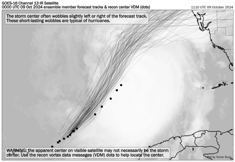
So tracking the recons fixes from 1:39 AM to 6:37 AM ET, Milton is heading on a 39 deg heading, a little left of true NE direction, if it keeps this heading it will make landfall in Longboat Key/Bradenton.
Based on the distance it has traveled, Milton is now moving at least above 17 mph. If it keeps up this speed, landfall will be near 8-9 PM tonight, much sooner than what global models show and much closer to the latest 06z hurricane models.

Based on the distance it has traveled, Milton is now moving at least above 17 mph. If it keeps up this speed, landfall will be near 8-9 PM tonight, much sooner than what global models show and much closer to the latest 06z hurricane models.
9 likes
-
eastcoastFL
- Category 5
- Posts: 3996
- Age: 44
- Joined: Thu Apr 12, 2007 12:29 pm
- Location: Palm City, FL
Re: ATL: MILTON - Hurricane - Discussion
There might be a bit of dry air intrusion to the west of center. It’s hard to tell for sure but man he is really deviating to the east right now.
0 likes
Personal Forecast Disclaimer:
The posts in this forum are NOT official forecast and should not be used as such. They are just the opinion of the poster and may or may not be backed by sound meteorological data. They are NOT endorsed by any professional institution or storm2k.org. For official information, please refer to the NHC and NWS products.
The posts in this forum are NOT official forecast and should not be used as such. They are just the opinion of the poster and may or may not be backed by sound meteorological data. They are NOT endorsed by any professional institution or storm2k.org. For official information, please refer to the NHC and NWS products.
Re: ATL: MILTON - Hurricane - Discussion
Trof is becoming negatively tilted
https://tropic.ssec.wisc.edu/real-time/ ... oom=&time=
https://tropic.ssec.wisc.edu/real-time/ ... oom=&time=
0 likes

Re: ATL: MILTON - Hurricane - Discussion
Forecast was right through 25N/85W. Dropsondes indicate Milton passed 85W at 24.8N. SO about 0.2 degrees or 15 miles south of the forecast track. Still south, but starting to move closer to the track (also the not-adjusted track before 5am) than a few hours ago.
1 likes

Re: ATL: MILTON - Hurricane - Discussion
USTropics wrote:birdwomn wrote:Nimbus wrote:
Perfect storms like Milton are more vulnerable to shear during EWRC, in fact the core winds can actually collide if the shear was strong enough but that is a miracle scenario that practically never happens.
Praying for that miracle!
It's been dealing with the shear so far, I think the question will be can the shear also entrain dry air today? That would lead to a more significant weakening event (06z GFS ensembles) instead of a more gradual one (00z ECMWF ensembles). This is definitely going to need a southern adjustment to the NHC cone at 11AM imo (see the models thread on 06z guidance coming in further south/east).
Yep, I think we're on the same page there
1 likes
Andy D
(For official information, please refer to the NHC and NWS products.)
(For official information, please refer to the NHC and NWS products.)
Re: ATL: MILTON - Hurricane - Discussion
eastcoastFL wrote:Storms are really starting to fill in to the east an north east
https://apps.sfwmd.gov/sfwmd/common/images/weather/noaaport/radar_flanim.gif
Those cells look very tornadic.
1 likes
Who is online
Users browsing this forum: No registered users and 27 guests