

135 kt at 5pm…I guess the NHC heard this forum’s complaints about how they handled Gilma and Kirk lol.
Still wild to see that Kristy is officially stronger than Kirk despite the latter getting a T7.0 on ADT. That SAB T6.5 really ruined its chances.
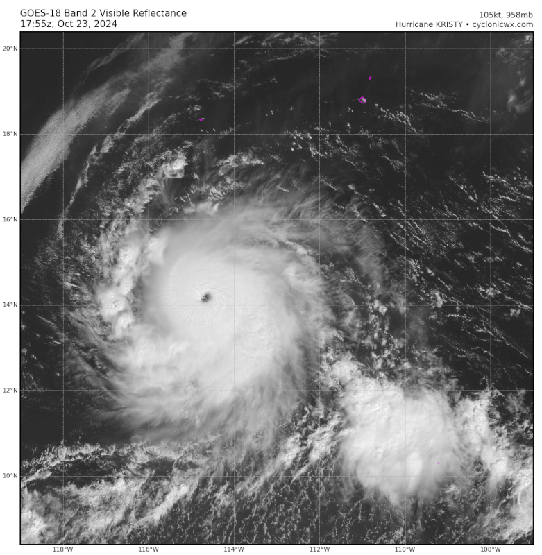
Not sure this’ll officially make it to a Cat 5, because it almost looks like there are signs of an outer eyewall on vis/IR.
EPAC: KRISTY - Remnants - Discussion
Moderator: S2k Moderators
Re: EPAC: KRISTY - Hurricane - Discussion
8 likes
Irene '11 Sandy '12 Hermine '16 5/15/2018 Derecho Fay '20 Isaias '20 Elsa '21 Henri '21 Ida '21
I am only a meteorology enthusiast who knows a decent amount about tropical cyclones. Look to the professional mets, the NHC, or your local weather office for the best information.
I am only a meteorology enthusiast who knows a decent amount about tropical cyclones. Look to the professional mets, the NHC, or your local weather office for the best information.
-
WaveBreaking

- Category 2

- Posts: 717
- Joined: Sun Jun 30, 2024 11:33 am
- Location: US
Re: EPAC: KRISTY - Hurricane - Discussion
RAMMB SLIDER is still adamant that Kristy will make a historic landfall over the Bay Area 

10 likes
I am NOT a professional meteorologist, so take all of my posts with a grain of salt. My opinions are mine and mine alone.
-
Kingarabian

- S2K Supporter

- Posts: 16345
- Joined: Sat Aug 08, 2009 3:06 am
- Location: Honolulu, Hawaii
Re: EPAC: KRISTY - Hurricane - Discussion
How quickly it can finish the ERC is key. But so far it's not hurting Dvorak estimates. It's still a T7.0. Just need it to hold for 3 more hours in time for the next SAB/TAFB fixes.
0 likes
RIP Kobe Bryant
-
Kingarabian
- S2K Supporter
- Posts: 16345
- Joined: Sat Aug 08, 2009 3:06 am
- Location: Honolulu, Hawaii
Re: EPAC: KRISTY - Hurricane - Discussion
Deep TCs moving west beneath a strong STR can do big things.
5 likes
RIP Kobe Bryant

Re: EPAC: KRISTY - Hurricane - Discussion
WaveBreaking wrote:RAMMB SLIDER is still adamant that Kristy will make a historic landfall over the Bay Area
https://i.imgur.com/Sbe69Zm.gif
We will rebuild!
1 likes
Re: EPAC: INVEST 90E - Discussion
Hurricane2022 wrote:Hot take: I think this will become a powerful C5 (unofficially of course)
Yes…
0 likes
-
Kingarabian
- S2K Supporter
- Posts: 16345
- Joined: Sat Aug 08, 2009 3:06 am
- Location: Honolulu, Hawaii
Re: EPAC: KRISTY - Hurricane - Discussion
WaveBreaking wrote:RAMMB SLIDER is still adamant that Kristy will make a historic landfall over the Bay Area
https://i.imgur.com/Sbe69Zm.gif
Fricking HAARP.
1 likes
RIP Kobe Bryant
-
AnnularCane

- S2K Supporter
- Posts: 2957
- Joined: Thu Jun 08, 2006 9:18 am
- Location: Wytheville, VA
Re: EPAC: KRISTY - Hurricane - Discussion
WaveBreaking wrote:RAMMB SLIDER is still adamant that Kristy will make a historic landfall over the Bay Area
https://i.imgur.com/Sbe69Zm.gif
Amazing how well she's doing over land.

2 likes
"But it never rained rain. It never snowed snow. And it never blew just wind. It rained things like soup and juice. It snowed mashed potatoes and green peas. And sometimes the wind blew in storms of hamburgers." -- Judi Barrett, Cloudy with a Chance of Meatballs
Re: EPAC: KRISTY - Hurricane - Discussion
ADT CI# Now at 7.0:
----- Current Analysis -----
Date : 23 OCT 2024 Time : 214021 UTC
Lat : 14:11:59 N Lon : 115:44:23 W
CI# /Pressure/ Vmax
7.0 / 926.9mb/140.0kt
Final T# Adj T# Raw T#
7.0 7.1 7.1
Estimated radius of max. wind based on IR : 12 km
Center Temp : +13.0C Cloud Region Temp : -73.7C
Date : 23 OCT 2024 Time : 214021 UTC
Lat : 14:11:59 N Lon : 115:44:23 W
CI# /Pressure/ Vmax
7.0 / 926.9mb/140.0kt
Final T# Adj T# Raw T#
7.0 7.1 7.1
Estimated radius of max. wind based on IR : 12 km
Center Temp : +13.0C Cloud Region Temp : -73.7C
1 likes
Re: EPAC: KRISTY - Hurricane - Discussion
Travorum wrote:ADT CI# Now at 7.0:----- Current Analysis -----
Date : 23 OCT 2024 Time : 214021 UTC
Lat : 14:11:59 N Lon : 115:44:23 W
CI# /Pressure/ Vmax
7.0 / 926.9mb/140.0kt
Final T# Adj T# Raw T#
7.0 7.1 7.1
Estimated radius of max. wind based on IR : 12 km
Center Temp : +13.0C Cloud Region Temp : -73.7C
If it succumbs to the EWRC then I think ADT could be enough for a post-season upgrade to Cat 5. An easier upgrade than Kirk despite also getting a T7.0.
0 likes
Irene '11 Sandy '12 Hermine '16 5/15/2018 Derecho Fay '20 Isaias '20 Elsa '21 Henri '21 Ida '21
I am only a meteorology enthusiast who knows a decent amount about tropical cyclones. Look to the professional mets, the NHC, or your local weather office for the best information.
I am only a meteorology enthusiast who knows a decent amount about tropical cyclones. Look to the professional mets, the NHC, or your local weather office for the best information.
-
Kingarabian
- S2K Supporter
- Posts: 16345
- Joined: Sat Aug 08, 2009 3:06 am
- Location: Honolulu, Hawaii
Re: EPAC: KRISTY - Hurricane - Discussion
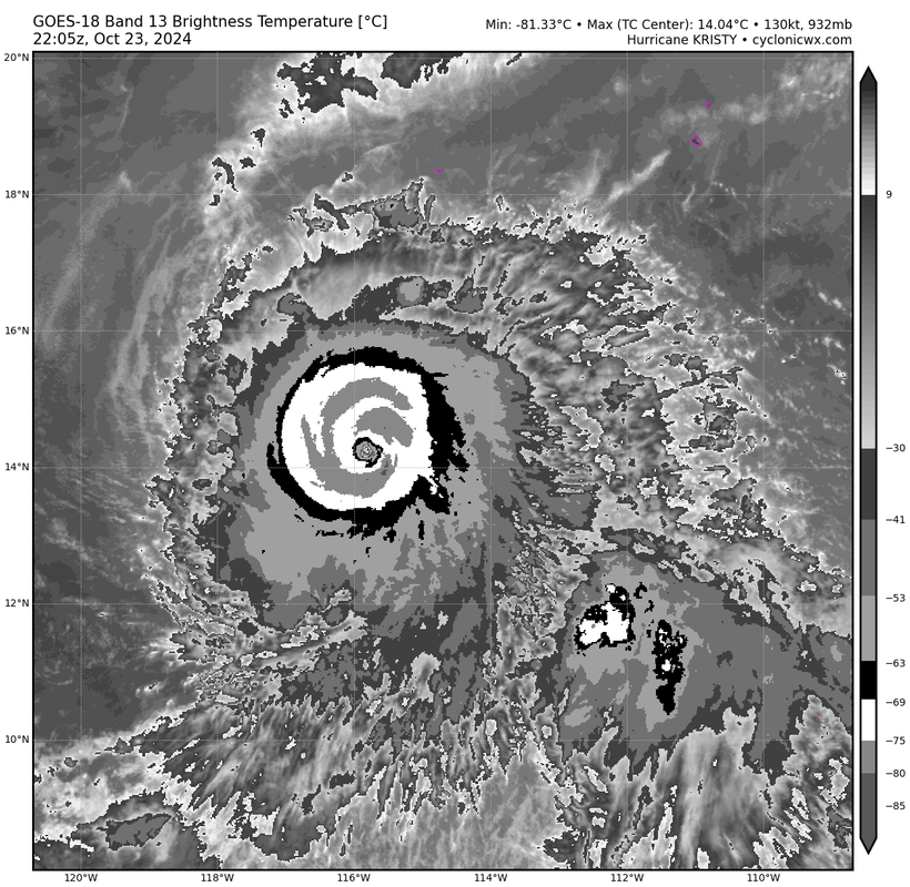
Well this frame is pushing T7.5. Certainly higher than a T7.0 because of the CMG but the thickness is questionable. But you can see there might be an ERC going on. Regardless, this is a Cat.5.
1 likes
RIP Kobe Bryant

Re: EPAC: KRISTY - Hurricane - Discussion
aspen wrote:Travorum wrote:ADT CI# Now at 7.0:----- Current Analysis -----
Date : 23 OCT 2024 Time : 214021 UTC
Lat : 14:11:59 N Lon : 115:44:23 W
CI# /Pressure/ Vmax
7.0 / 926.9mb/140.0kt
Final T# Adj T# Raw T#
7.0 7.1 7.1
Estimated radius of max. wind based on IR : 12 km
Center Temp : +13.0C Cloud Region Temp : -73.7C
If it succumbs to the EWRC then I think ADT could be enough for a post-season upgrade to Cat 5. An easier upgrade than Kirk despite also getting a T7.0.
Kirk had a clearer and more rounded-out eye, but it's hard to argue against this convection. On a fast track to a T7.0 fix at 0z barring any convective collapse.
2 likes
Kendall -> SLO -> PBC
Memorable Storms: Katrina (for its Florida landfall...) Wilma Matthew Irma
Memorable Storms: Katrina (for its Florida landfall...) Wilma Matthew Irma
Re: EPAC: KRISTY - Hurricane - Discussion
Really impressive imagery from NOAA21 about 1.5 hours ago. Looks like that outer band is starting to wrap around closer.
https://x.com/zeb199818/status/1849205171991306555
https://x.com/zeb199818/status/1849205171991306555
0 likes


-
Kingarabian
- S2K Supporter
- Posts: 16345
- Joined: Sat Aug 08, 2009 3:06 am
- Location: Honolulu, Hawaii
Re: EPAC: KRISTY - Hurricane - Discussion
Eye has Cooled. Will be interesting to see if it can bounce back. Has 24 hours of ideal conditions left and 48 hours of decent conditions.
3 likes
RIP Kobe Bryant
Re: EPAC: KRISTY - Hurricane - Discussion
00z fix T6.5
TXPZ29 KNES 240024
TCSENP
A. 12E (KRISTY)
B. 24/0000Z
C. 14.2N
D. 116.4W
E. ONE/GOES-W
F. T6.5/6.5
G. IR/EIR/VIS
H. REMARKS...CLOUD-FILLED OW EYE SURROUNDED BY CMG AND EMBEDDED IN W
RESULTS IN AN E# OF 6.0 WITH EADJ +0.5 FOR A DT OF 6.5. 2121Z AMSR2
PASS SHOWED SLIGHT WEAKNESS IN N EYEWALL RING. EYE HAS BECOME A BIT
LESS DEFINED LAST SVRL HR. UPR-LVL OUTFLOW VERY GOOD ALQDS. MET=6.0 AND
PT=6.5. FT BASED ON DT.
I. ADDL POSITIONS
NIL
...KONON
0 likes
Re: EPAC: KRISTY - Hurricane - Discussion
135kt at the 00z best track. Add it to the list of anticipated TCRs
genesis-num, 032,
EP, 12, 2024102400, , BEST, 0, 142N, 1164W, 135, 928, HU
EP, 12, 2024102400, , BEST, 0, 142N, 1164W, 135, 928, HU
1 likes
-
Yellow Evan

- Professional-Met

- Posts: 16231
- Age: 27
- Joined: Fri Jul 15, 2011 12:48 pm
- Location: Henderson, Nevada/Honolulu, HI
- Contact:
Re: EPAC: KRISTY - Hurricane - Discussion
ERC is underway given the bursting pattern and eye contraction.
Pretty classical case of a close call of Category 5 but we never got persistent T7.0 that we often see in this basin.
Pretty classical case of a close call of Category 5 but we never got persistent T7.0 that we often see in this basin.
2 likes
Re: EPAC: KRISTY - Hurricane - Discussion
Travorum wrote:135kt at the 00z best track. Add it to the list of anticipated TCRsgenesis-num, 032,
EP, 12, 2024102400, , BEST, 0, 142N, 1164W, 135, 928, HU
This has a better chance of getting a post-season Cat 5 upgrade than Kirk because it’s already pretty close to one. Meanwhile, Kirk was assessed so low and the NHC usually doesn’t do big post-season upgrades, even though there’s evidence Kirk was at least 10 kt stronger than operationally assessed.
1 likes
Irene '11 Sandy '12 Hermine '16 5/15/2018 Derecho Fay '20 Isaias '20 Elsa '21 Henri '21 Ida '21
I am only a meteorology enthusiast who knows a decent amount about tropical cyclones. Look to the professional mets, the NHC, or your local weather office for the best information.
I am only a meteorology enthusiast who knows a decent amount about tropical cyclones. Look to the professional mets, the NHC, or your local weather office for the best information.
-
CrazyC83
- Professional-Met
- Posts: 34315
- Joined: Tue Mar 07, 2006 11:57 pm
- Location: Deep South, for the first time!
Re: EPAC: KRISTY - Hurricane - Discussion
If there is an upgrade, it may be at a non-synoptic time (say, 2100Z) as that is when ADT estimates peaked.
2 likes
Who is online
Users browsing this forum: No registered users and 32 guests