
Low Pressure developing in the Southwest Caribbean Sea (Is Invest 97L)
Moderator: S2k Moderators
Forum rules

The posts in this forum are NOT official forecasts and should not be used as such. They are just the opinion of the poster and may or may not be backed by sound meteorological data. They are NOT endorsed by any professional institution or STORM2K. For official information, please refer to products from the National Hurricane Center and National Weather Service.
-
cycloneye

- Admin

- Posts: 149843
- Age: 69
- Joined: Thu Oct 10, 2002 10:54 am
- Location: San Juan, Puerto Rico
Low Pressure developing in the Southwest Caribbean Sea (Is Invest 97L)
NHC has not added a area of interest with a lemon, but I decided to make this thread as there is an actual incipient area of convection in the SW Caribbean. The models are not on a consensus about development nor tracks. Let's see how all transpires in the next few days.
9 likes
Visit the Caribbean-Central America Weather Thread where you can find at first post web cams,radars
and observations from Caribbean basin members Click Here
and observations from Caribbean basin members Click Here
-
tropicwatch

- Category 5

- Posts: 3427
- Age: 62
- Joined: Sat Jun 02, 2007 10:01 am
- Location: The Villages, Florida
- Contact:
Re: Disturbed weather in the SW Caribbean Sea
What little vorticity there is, most of it is at the 925mb level.
https://tropic.ssec.wisc.edu/real-time/windmain.php?&basin=atlantic&sat=wg8&prod=vor5&zoom=&time=
https://tropic.ssec.wisc.edu/real-time/windmain.php?&basin=atlantic&sat=wg8&prod=vor5&zoom=&time=
1 likes
Tropicwatch
Agnes 72', Eloise 75, Elena 85', Kate 85', Charley 86', Florence 88', Beryl 94', Dean 95', Erin 95', Opal 95', Earl 98', Georges 98', Ivan 2004', Arlene 2005', Dennis 2005', Ida 2009' Debby 2012' Irma 2017' Michael 2018'
Agnes 72', Eloise 75, Elena 85', Kate 85', Charley 86', Florence 88', Beryl 94', Dean 95', Erin 95', Opal 95', Earl 98', Georges 98', Ivan 2004', Arlene 2005', Dennis 2005', Ida 2009' Debby 2012' Irma 2017' Michael 2018'

Re: Disturbed weather in the SW Caribbean Sea
What's that blob of shear to the east of it?

Last edited by Pasmorade on Fri Oct 25, 2024 10:27 am, edited 1 time in total.
0 likes
-
MEANINGLESS_NUMBERS
- Category 2

- Posts: 503
- Joined: Mon Nov 02, 2020 1:43 pm
Re: Disturbed weather in the SW Caribbean Sea
GFS has genesis in about 5 days so expect a lemon soon. Other model support much weaker but the GFS has shown this for 10+ runs.
1 likes
Emily '87, Felix '95, Gert '99, Fabian '03, Humberto '19, Paulette '20, Teddy '20, Fiona '22, Lee '23, Ernesto '24, Humberto/Imelda '25
-
TomballEd
- Category 5
- Posts: 1344
- Age: 62
- Joined: Wed Aug 16, 2023 4:52 pm
- Location: Spring/Klein area, not Tomball
Re: Disturbed weather in the SW Caribbean Sea
MEANINGLESS_NUMBERS wrote:GFS has genesis in about 5 days so expect a lemon soon. Other model support much weaker but the GFS has shown this for 10+ runs.
Some support from the other models, Canadian ensembles see it. Euro ensembles still see it, but have backed off just a bit. Perhaps the satellite acquired data from the blowup will make it into the 12Z models. If not, they will be in 18Z models
0 likes

Re: Disturbed weather in the SW Caribbean Sea
Steering pattern might pull it north over the coast of Nicaragua?
0 likes
Re: Disturbed weather in the SW Caribbean Sea
Definitely has that look, my guess based on where it is it will move over in to the East Pacific and might become something there.
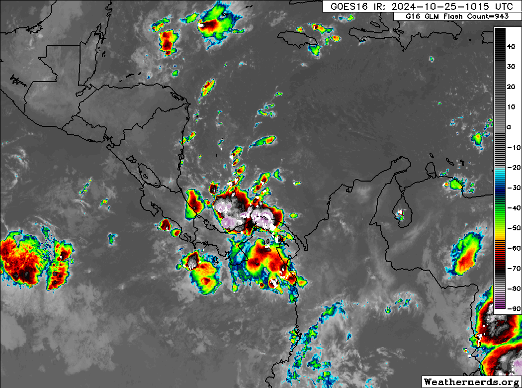
GOES-16 GeoProxy + Tropical Airmass (that's why it's pink and helps to show the clouds better)

GOES-16 GeoProxy + Tropical Airmass (that's why it's pink and helps to show the clouds better)
4 likes
-
cycloneye
- Admin
- Posts: 149843
- Age: 69
- Joined: Thu Oct 10, 2002 10:54 am
- Location: San Juan, Puerto Rico
Re: Disturbed weather in the SW Caribbean Sea
No lemon at 2 PM.
Tropical Weather Outlook
NWS National Hurricane Center Miami FL
200 PM EDT Fri Oct 25 2024
For the North Atlantic...Caribbean Sea and the Gulf of Mexico:
Tropical cyclone formation is not expected during the next 7 days.
$$
Forecaster Blake
NWS National Hurricane Center Miami FL
200 PM EDT Fri Oct 25 2024
For the North Atlantic...Caribbean Sea and the Gulf of Mexico:
Tropical cyclone formation is not expected during the next 7 days.
$$
Forecaster Blake
3 likes
Visit the Caribbean-Central America Weather Thread where you can find at first post web cams,radars
and observations from Caribbean basin members Click Here
and observations from Caribbean basin members Click Here
-
StormPyrate
- Category 1

- Posts: 286
- Joined: Sun May 27, 2018 8:41 pm
- Location: Clearwater, FL
Re: Disturbed weather in the SW Caribbean Sea
You tubers and other social media drubs are using this to seed fear and anxiety to promote clicks
Its sad.
The folks that could be impacted by this do not need that level of disinformation.
Its sad.
The folks that could be impacted by this do not need that level of disinformation.
0 likes
St Petersburg Florida
Re: Disturbed weather in the SW Caribbean Sea
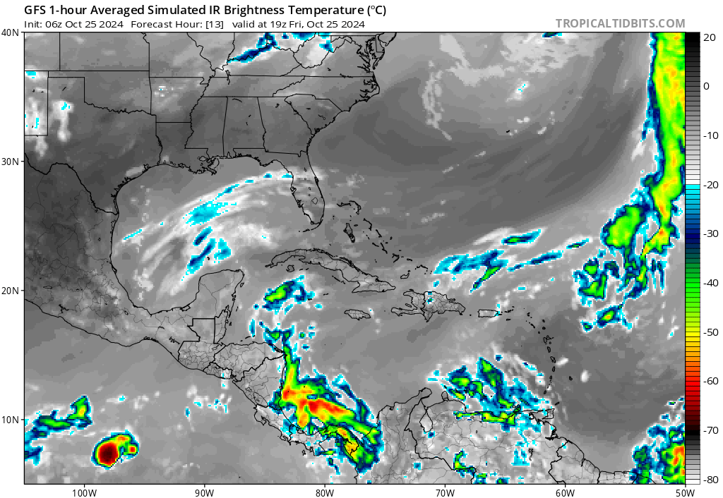
This isn't the system that you see in the models that is 5 days away if it happens. This is just a large meso cell that pop up all the time in that area often drift into the pacific and become storms there.
0 likes

Re: Disturbed weather in the SW Caribbean Sea
ChrisH-UK wrote:This isn't the system that you see in the models that is 5 days away if it happens. This is just a large meso cell that pop up all the time in that area often drift into the pacific and become storms there.
Looking at the simulated IR satellite, the GFS and Canadian both suggest this area will be at least part of the potential system that might develop.
That said, I would be surprised in the NHC has a lemon before Monday.
1 likes
-
johngaltfla

- Category 5
- Posts: 2074
- Joined: Sun Jul 10, 2005 9:17 pm
- Location: Sarasota County, FL
- Contact:
Re: Disturbed weather in the SW Caribbean Sea
cycloneye wrote:No lemon at 2 PM.Tropical Weather Outlook
NWS National Hurricane Center Miami FL
200 PM EDT Fri Oct 25 2024
For the North Atlantic...Caribbean Sea and the Gulf of Mexico:
Tropical cyclone formation is not expected during the next 7 days.
$$
Forecaster Blake
I'm with you sir. Puerto Rico and the USVI/BVI/Bahamas do not need a hit. Florida took it all for our friends down there.
Let it go into the EPAC.
0 likes
-
Stormlover70
- Tropical Storm

- Posts: 194
- Age: 56
- Joined: Fri Jun 21, 2024 5:31 am
- Location: New port richey
Re: Disturbed weather in the SW Caribbean Sea
The pattern with the high seems to indicate the Florida peninsula is safe at this point.
0 likes
-
HurricaneBelle

- S2K Supporter

- Posts: 1209
- Joined: Sun Aug 27, 2006 6:12 pm
- Location: Clearwater, FL
Re: Disturbed weather in the SW Caribbean Sea
18Z GFS shows a Cat 1 hit on Hispanola then moves through the Turks & Caicos before heading OTS southeast of Bermuda
0 likes
-
weeniepatrol

- Category 5
- Posts: 1346
- Joined: Sat Aug 22, 2020 5:30 pm
- Location: WA State
Re: Disturbed weather in the SW Caribbean Sea
EPS remains quite flaccid through ten days. Need to see support increasing.
That being said, CPC as of 22 October had a 40-60% chance of development over the region.
https://www.cpc.ncep.noaa.gov/products/precip/CWlink/ghaz/index.php
That being said, CPC as of 22 October had a 40-60% chance of development over the region.
https://www.cpc.ncep.noaa.gov/products/precip/CWlink/ghaz/index.php
The Madden-Julian Oscillation (MJO) completed a circumnavigation of the global tropics by mid-October with its enhanced phase currently over the Maritime Continent. During the past week, the MJO strengthened based on the RMM index and the 200-hPa velocity potential anomalies. Recently, the anomalous upper-level divergence (convergence) increased over the Maritime Continent (Americas and Africa). Despite destructive interference between the MJO and the emerging weak La Nina during the next week, the GFS and ECMWF models are in good agreement and consistent that a moderate to strong MJO propagates eastward to the western Hemisphere. By early November, the MJO is predicted to shift east from the Americas to Africa and the Indian Ocean.
A pair of tropical cyclones (Nadine and Oscar) formed over the Atlantic basin this past week. Nadine was a short-lived TC and Oscar rapidly became a hurricane as it tracked north of Hispaniola. The GFS and ECMWF ensemble members support a 40 to 60 percent chance of TC development across the Caribbean Sea from October 30 to November 5. Many of these ensemble members depict TC genesis occurring as early as October 29. Regardless of the exact timing, forecast confidence is high that another TC forms across the Caribbean Sea by the end of October. Model guidance is also depicting an elevated chance of a subtropical low pressure system or tropical cyclone forming at a higher latitude over the southwestern Atlantic. This would be consistent with climatology and thus a 20 to 40 percent chance is posted for this region during week-2. From November 6 to 12, a 20 to 40 percent chance of TC development is posed for the Caribbean Sea based on climatology and since the MJO is likely to maintain a favorable large-scale environment for a late season TC through at least mid-November.
2 likes
Re: Disturbed weather in the SW Caribbean Sea
cycloneye wrote:No lemon at 2 PM.Tropical Weather Outlook
NWS National Hurricane Center Miami FL
200 PM EDT Fri Oct 25 2024
For the North Atlantic...Caribbean Sea and the Gulf of Mexico:
Tropical cyclone formation is not expected during the next 7 days.
$$
Forecaster Blake
No lemon.....so...we make lemonade....yall have a great night.....maybe tomorrow the NHC will highlight the NW...or western carribean?...
5 likes
Re: Disturbed weather in the Western Caribbean Sea
The ensemble means definitely suggest something by 180


0 likes
Who is online
Users browsing this forum: No registered users and 57 guests