#2502 Postby underthwx » Fri Nov 08, 2024 4:40 pm
This is the current discussion from the Global Tropical hazards outlook, as im sure most of you are already familiar with. I stumbled upon it, and wanted to share it.
"GTH Outlook Discussion
Last Updated - 11/05/24
Valid - 11/13/24 - 11/26/24
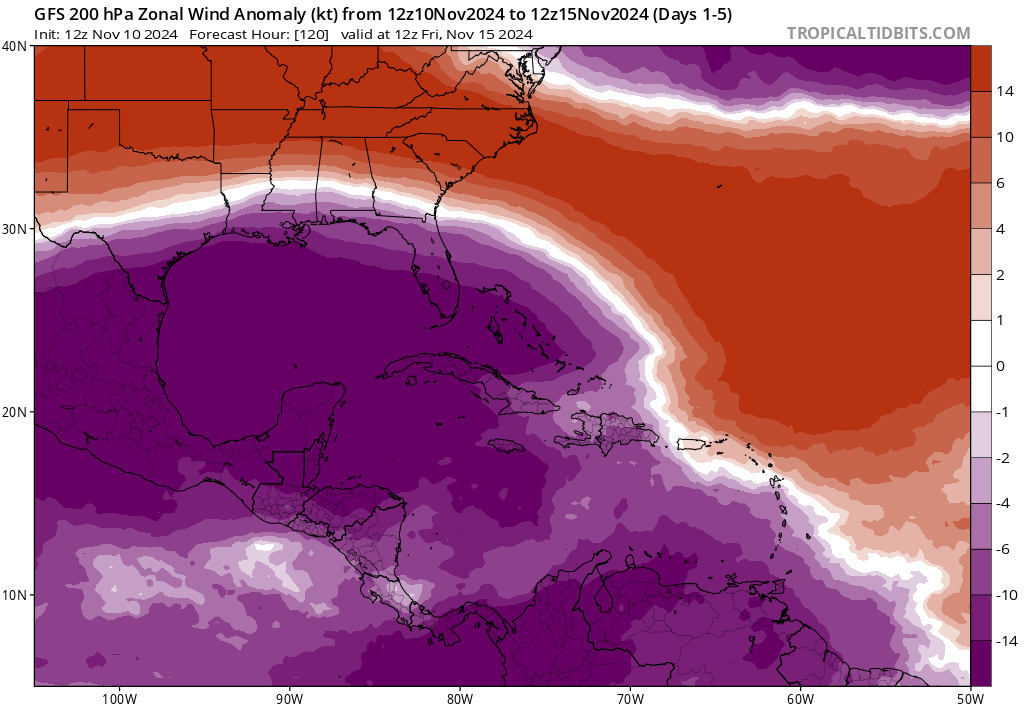
Recent observations and both the RMM based and CPC velocity potential based MJO indices indicate that a robust MJO event continues into early November, with the enhanced convective phase crossing the Western Hemisphere. This intraseasonal signal is currently the dominant mode of tropical variability, despite destructive interference with the low frequency base state favoring suppressed convection over the equatorial central Pacific. As the MJO enhanced convective envelope crossed the Pacific at the end of October and the beginning of November, the trade wind regime weakened, easterly anomalies developed aloft, and a Pacific jet extension developed over the northeastern Pacific and portions of North America. There is uncertainty whether this enhanced MJO event will have a substantial impact on the oceanic thermocline of the Pacific. While a strong westerly wind burst was initiated over the Pacific, the strongest westerlies were located well north of the Equator, which reduces the impact. Still, it is possible that this recent activity may result in the initiation of a downwelling oceanic Kelvin wave, and there are some indications of an eastward expansion of the above-average West Pacific warm pool.
Dynamical model MJO index forecasts are in good agreement supporting continued MJO activity during the outlook period, with the GEFS favoring a slower and more amplified evolution, and the ECMWF favoring a faster propagation of an overall weaker signal. Given the highly organized structure of the ongoing MJO event, there is fairly high confidence that the MJO will continue to play a large to dominant role in the global tropical convective pattern, with the enhanced convective phase continuing to cross the Western Hemisphere during Week-1, and the Indian Ocean and possibly the Maritime Continent during Weeks 2 and 3. Therefore, enhanced low-level westerlies over the eastern Pacific and Caribbean during the outlook period may yield a favorable environment for late season tropical cyclone development. As the suppressed envelope of the MJO crosses the Pacific during the outlook period, a trade wind surge is favored, which may help to strengthen the low frequency base state as the Boreal winter season approaches. Given the extent of warm water across the western Pacific, however, MJO activity may persist beyond the outlook period.
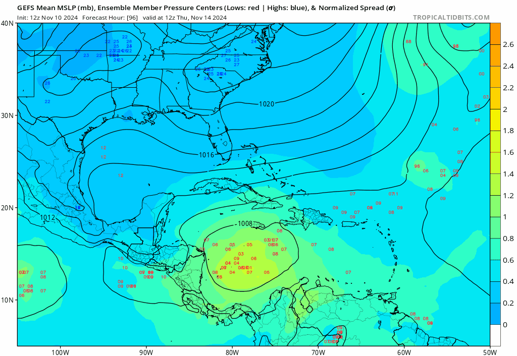
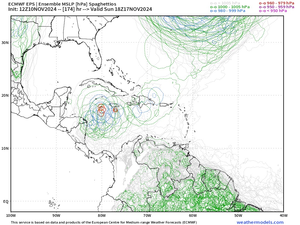
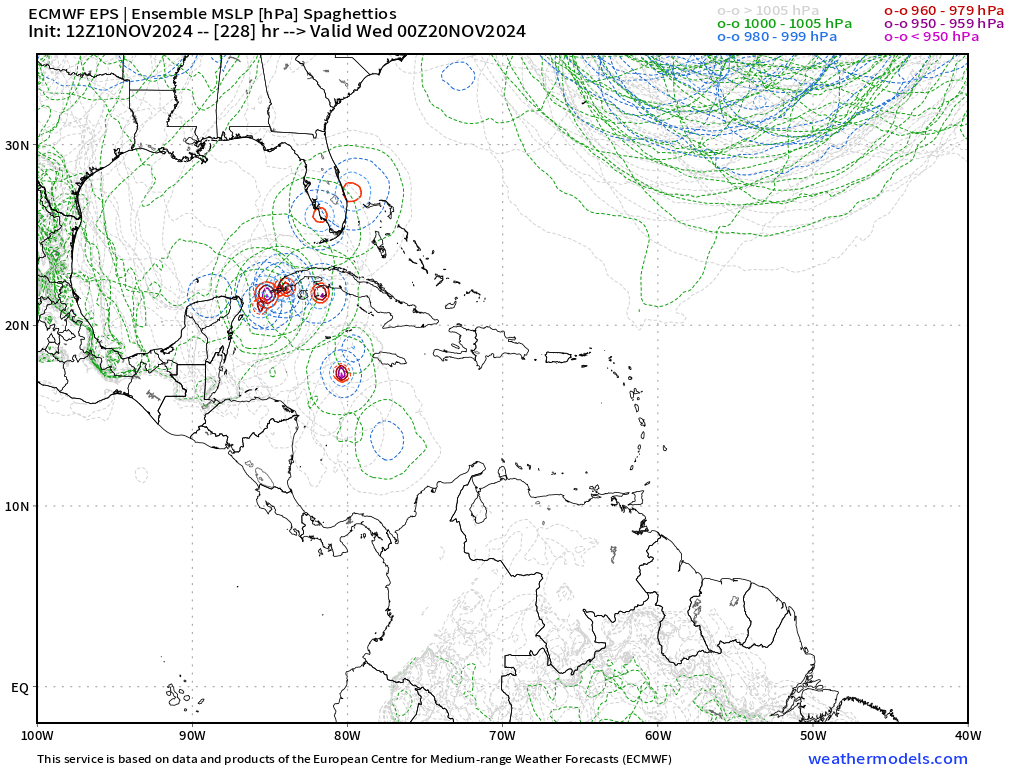
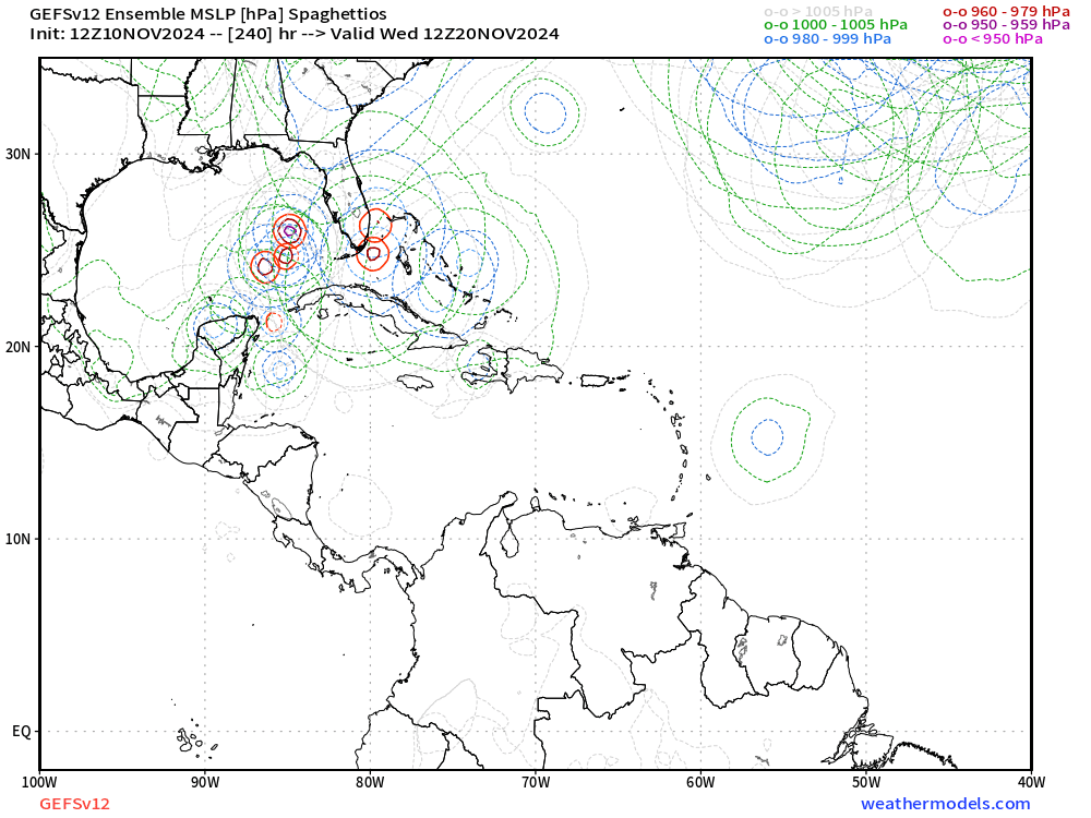
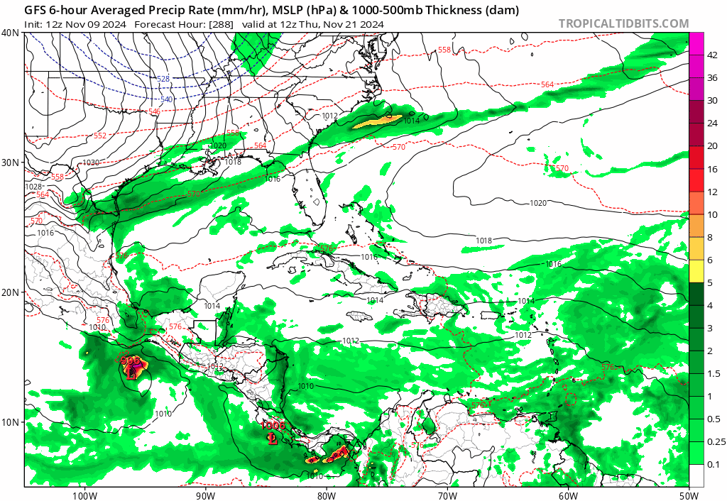
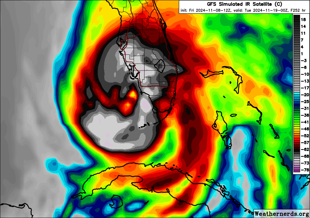
Four tropical cyclones (TCs) formed during the past week. On November 2, Tropical Storm Lane developed over the East Pacific far southwest of the Baja California peninsula. The system dissipated shortly thereafter. Tropical Storm Patty also formed on November 2 over the central Atlantic near 40N. On November 3, Typhoon Yinxing formed east of the Philippines. This system continues to intensify, and forecasts from the Joint Typhoon Warning Center bring the center of circulation near or north of the island of Luzon during the next several days before emerging over the South China Sea. On November 4, Tropical Storm Rafael developed over the central Caribbean Sea. Forecasts from the National Hurricane Center indicate strengthening to hurricane intensity, with the TC bringing impacts to Jamaica and Cuba before emerging over the Gulf of Mexico, where increased shear may begin to weaken the system. Interests along the US Gulf Coast should continue to monitor forecasts from the NHC and their local NWS forecast offices. During the Week-2 period, continued low-level westerly anomalies across the eastern Pacific and Caribbean will provide a favorable environment for late season tropical cyclone development. Dynamical model forecasts do not consistently indicate any specific regions for development, but forecasts show potential closed lows forming from a broad cyclonic gyre over the western or central Caribbean as well as the western Atlantic in the vicinity of the Turks and Caicos islands. The MJO evolution also favors tropical cyclone development over the southwestern Indian Ocean, particularly in the region near or north of Madagascar. During Week-3, similar regions remain favored, though the potential for East Pacific development declines considerably as the MJO suppressed phase crosses the Pacific.
Forecasts for above- and below-average precipitation during Weeks 2 and 3 are based on historical composites of Indian Ocean and Maritime Continent MJO events, a low frequency state leaning towards La Niña, and a skill consolidated blend of dynamical model guidance. Widespread above-average precipitation is favored to develop across the Indian Ocean basin during the outlook period, with enhancement spreading across the equatorial Maritime Continent. Less wetness was indicated for the equatorial eastern Indian Ocean based on model guidance, which may be attributed to subsidence from tropical cyclone activity or equatorial Rossby wave activity. In contrast, suppressed rainfall is favored across the central Pacific due to constructive interference between the MJO suppressed phase and the low frequency base state. Above-normal temperatures are indicated for portions of the eastern U.S. during week-2. For hazardous weather conditions in your area during the coming two-week period, please refer to your local NWS office, the Medium Range Hazards Forecast produced by the Weather Prediction Center, and the CPC Week-2 Hazards Outlook. Forecasts made over Africa are made in coordination with the International Desk at CPC."
I realize a good portion of this outlook seems to be centered around the Pacific, and Indian Ocean basins, but it has some excellent references to the Atlantic and Carribean basins as well, which I found to be extremely interesting personally, and it helped shed some light to me, on what the heck is going on out there!
0 likes


